The British Columbia Wildfire Service released this information late Sunday night, July 5, 2015:
We sign off with heavy hearts tonight. We were saddened to learn that a contract tree faller working with us on the Old Sechelt Mine fire suffered a fatal injury while felling a danger tree earlier today. Our thoughts and prayers go out to his friends, family and co-workers.
This is a tragic reminder of the dangerous work being done by personnel across the province to respond to wildfires.
Our sincere condolences go out to the family, friends, and co-workers.
The Old Sechelt Mine Fire has burned 80 hectares (198 acres) since it was discovered July 2 two km northwest of Sechelt.
UPDATE at 7:30 p.m. MT, July 6, 2015: Kelowna Now reports that the coroner has identified the faller as John Joe Phare, age 60, from Roberts Creek.
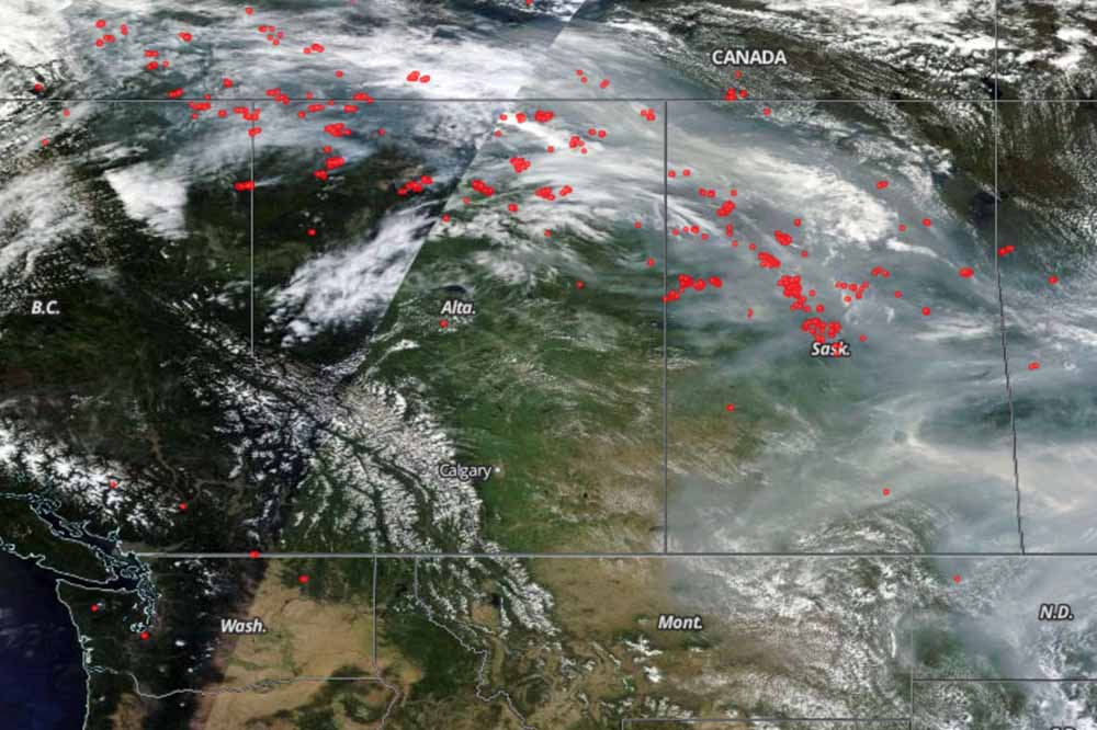
A satellite view of the location of fires in Canada July 2, 2015, represented by the red dots. Smoke can be seen drifting to the south and southeast.
You don’t usually think of smoke benefiting firefighters, especially their health, but the pollutants over a very widespread area are modifying the weather, making it a little easier to corral the numerous wildfires in some areas.
Below is an excerpt from The Weather Network.
Thursday, July 2, 2015, 5:14 PM – Even as plumes of heavy smoke from Alberta and Saskatchewan wildfires force thousands from their homes, officials find a silver lining, as the smoke is actually keeping the fires more under control.
Evacuation centres in central and southern Saskatchewan are reportedly housing at least 5,000 people as of Thursday, all displaced from their homes by thick smoke drifting down from wildfires burning in northern parts of the province. The evacuations were prompted by the significant health risk this smoke represents, and Environment Canada has issued special air quality statements for northeastern Alberta, all of Saskatchewan and all but the northeastern regions of Manitoba in response.
Despite this health risk, though, the thick smoke is actually having a beneficial impact on the very fires that are producing it in the first place.
“As much as it’s not good for people, because the cloud layer filled with smoke and is so thick, our temperatures are roughly 10 degrees cooler and our humidity is 10 to 15 per cent higher,” said Steve Roberts, Executive Director of Saskatchewan’s Wildfire Management Branch, according to the Canadian Press. “That combination means the fire activity drops significantly.”
“It’s helped us secure, especially, those fires that are close to communities by putting people on the ground and getting some hose lines in place.”
But, the smoke is a double-edged sword. Sometimes the reduced visibility grounds firefighting aircraft:
Air Tankers at Dryden (Ontario) Regional Airport last week before they were dispersed to deal with the rising number of wildfires. Photo by Chris Sherwin. Click to enlarge.
Mike sent us this photo taken by Chris Sherwin of firefighting aircraft based at Dryden Regional Airport in Ontario, Canada. He said, “There are 7 CL-415, 1 DHC-6, 2 DHC-2T and 1 EC-130 and owned by the Province of Ontario”.
Cisco Road Fire, June 11, 2015. Photo by B.C. Wildfire Management Branch.
The British Columbia Wildfire Management Branch says the Cisco Road Fire south of Lytton, B.C. has been mapped at 1,500 hectares (3,700 acres). The size will increase as the fire crews conduct strategic burning operations.
Cisco Road Fire, June 11, 2015. Photo by B.C. Wildfire Management Branch.
Firefighters will be watching for high winds today — predicted to be southerly for most of Friday morning, with the chance of a shift to northerly later in the afternoon. Crews did experience a trace amount of precipitation on some areas of the fire Friday morning.
****
Cisco Road Fire south of Lytton, BC at 3:22 pm PT June 11, 2015.
(UPDATE at 5:29 p.m. PT, June 11, 2015)
The British Columbia Wildfire Management Branch said at 2:58 PT that the new wildfire, now named Cisco Road Fire, west of the Fraser River south of Lytton (map) has burned about 600 hectares (1,482 acres) and is zero percent contained:
This fire is displaying aggressive fire behaviour (Rank 5) and is located in difficult terrain [Rank 5 fire behaviour is a crown fire that has the potential for short-range spotting] . Winds 40 gusting 60 km/hr [25 mph gusting to 37 mph] from the south are continuing to challenge suppression efforts. There are currently 22 firefighters on site, with 20 more en route. Three helicopters are providing bucking support for ground crews.
An Evacuation Alert and Order have been issued by the Lytton First Nations Band for nearby First Nations communities.
I wonder about the future of the live cam that is getting these great photos? If the wind shifts to come out of the north, it will probably be toast, unless it can be evacuated, or unless it has sufficient clearance around it. I think the cam is looking north, and that jives with the south wind described above..
****
(Originally published at 2:32 p.m. PT, June 11, 2015)
An image grabbed from a live web cam of a fire south of Lytton, B.C. at 3:22 p.m. MT, June 11, 2015.
A new wildfire south of Lytton, B.C. has gotten a running start up a steep slope, as you can see in the photo that was captured by a live camera operated by Lyttonnet. Not much information is available yet, but CBC News reported at 1:57 p.m. PT that it was 150 hectares (370 acres) on the west side of the Fraser River. The B.C. Wildfire Management Branch says the fire was reported around noon and is threatening structures near Lytton, roughly 100 kilometers north of Hope.
The two articles about the fitness test for wildland firefighters in the United States published yesterday on Wildfire Today have generated significant interest so far, judging from the number of comments left by our readers in the last 24 hours. The fitness test we are referring to is the Pack Test version of the Work Capacity Test which requires carrying 45 pounds (20.4 kg) for three miles on flat ground (4.83 km) in less than 45 minutes. Federal land management agencies in the U.S. and some fire departments require that firefighters pass the test each year in order to work on the fireline.
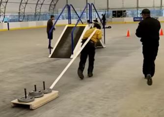
We learn a lot from comments left by our readers. “BC Initial Attack” informed us about the fitness test required of Type 1 Firefighters in Canada. The WFX-FIT, which first saw widespread use in 2012, is described as “a valid job-related physical performance standard used to determine whether an individual possesses the physical capabilities necessary to meet the rigorous demands encountered while fighting wildland fires.”
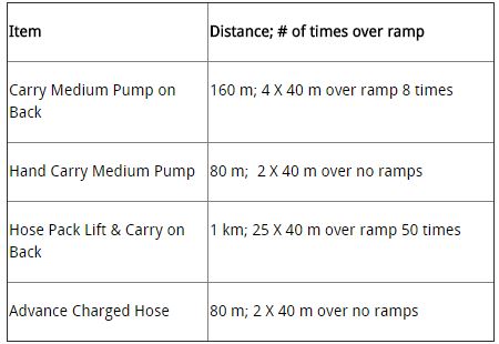
The components of the WFX-FIT, after pre-participation screening are:
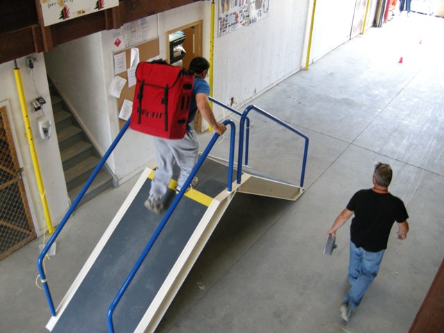
The pump, or simulated pump, weighs 62.7 pounds (28.5 kg). The simulated hose that is dragged is represented by a 40.7 pound (18.5 kg) weighted sled. The hose pack weighs 55 pounds (25 kg).
Firefighters must be able to complete the test within 14 minutes and 30 seconds to be eligible for the National Exchange. The Ontario Provincial Standard is 17 minutes and 15 seconds, the Alberta Provincial Standard is 14 minutes and 20 seconds, and the British Columbia standard is 14 minutes and 30 seconds. A score between 14 minutes and 31 seconds and 17 minutes and 15 seconds will meet the Ontario Provincial Standard but will not permit deployment outside of Ontario.
The photos are from the WFX-FIT website and the above video.
For several days the name of the Conair pilot killed in the May 22 crash of an air tanker in Alberta was not released, but now we know that his name was William Hilts.
Though the family of William Hilts is grieving his loss after the plane he was piloting crashed near Cold Lake, Alta., on May 22, where he was fighting wildfires, they have found comfort in the outpouring of condolences and gratitude from the community.
“It gives us a side of him that we never thought of. We always thought of him as a pilot more than a firefighter, but then you realize the role that those guys play in the community,” said his father, Stuart Hilts.
The 38-year-old pilot was fighting wildfires in an Air Tractor AT-802 “Fire Boss” amphibious water bomber for Conair Aerial Firefighting, under contract to Alberta Environment and Sustainable Resource Development (ESRD), when his plane crashed on the Cold Lake Air Weapons Range on May 22 around 5:20 p.m…
Our sincere condolences go out to the family, friends, and co-workers of Mr. Hilts.
The British Columbia government has a very interesting website that provides a forecast for wildfire smoke. The image above is for Monday, June 1, and the one below is for Wednesday, June 3.
Wildfire smoke forecast for Canada on June 3.
To see the most current smoke reports on Wildfire Today, visit the articles tagged “smoke” at https://wildfiretoday.com/tag/smoke/
— Town of Slave Lake (@TownSlaveLake) May 26, 2015
Fire officials are calling the fire “held”, which means it will not grow under the current weather conditions and firefighting actions that have been taken on the fire.
It has been mapped at 139 hectares (343 acres). Still assigned to the fire are 40 firefighters and six helicopters.
“The lone occupant of a firefighting plane that crashed Friday afternoon [May 22, 2015] in northern Alberta has died, a company spokesman confirmed.
Jeff Berry of Conair Aerial Firefighting told Postmedia Network that the plane, an AT-802 Fireboss amphibious water bomber, crashed just after 4:30 p.m. MDT, about 40 km north of Cold Lake near the Saskatchewan border.
Crews are fighting an out-of-control 300 ha wildfire in the area, in the vicinity of Burnt Lake, Alta., near the CFB Cold Lake’s weapons range and an Imperial Oil facility.
Berry said the 37-year old pilot was no stranger to fighting wildfires.
“This was his fourth season, so he was well-experienced,” Berry said.
Berry said the single-seater plane was relatively new, built in 2009.
File photo of one of Conair’s AT-802F Fire Boss air tankers. Photo by Peter Unmuth.
He expressed his condolences to the friends and family of the pilot, and expressed his gratitude to Alberta Environment and Sustainable Resource Development (ESRD) and Cold Lake Search and Rescue for their quick response.
The Transportation Safety Board of Canada was sending an investigation team, expected to arrive Saturday morning, TSB spokesman Julie Leroux confirmed.
Cold Lake is about 230 km northeast of Edmonton.”
****
Our sincere condolences go out to the the pilot’s family, friends, and to Conair.
The fire is in the Cold Lake Weapons Range, 40 km (25 miles) north of Cold Lake near Burnt Lake, and has burned approximately 3000 hectares (7400 acres).
“Predicting the weather may not always be an easy task, but meteorologists are beginning to agree B.C. is in for a long, hot summer. Pennsylvania-based AccuWeather released its forecast Thursday, agreeing with last week’s prediction from Environment Canada that, for large parts of B.C., the heat is on.
“Sea temperatures have been averaging two or three degrees above normal across the Eastern Pacific,” Brett Anderson, senior meteorologist with AccuWeather told CBC News.
“That’s going to have a warming influence on places such as Vancouver, Victoria and even placed further inland.”
Anderson says that the higher sea temperatures combined with the effects of El Niño will mean the south coast will be one to one-and-a-half degrees warmer, but things are likely to be more dramatic in the interior.
“It does look fairly dry though the summer and the wildfire threat will be fairly high, ” Anderson said.
Nevertheless, while the B.C. Wildfire Management Branch say they do monitor long-term forecasts, their operations are planned on a short-term basis.
“As of right now, we’re looking to the immediate future.” fire information officer Melissa Klassen told CBC News. “We can always call in other resources if activities pick up.” “