Man faces charges for starting wildfire with exploding target in Colorado

These dangerous devices are banned in many areas and have started many fires in the United States

Above: Firefighters suppress a fire started by a person shooting at an exploding target southeast of Eagle, Colorado June 9, 2018. Photo by Eagle River Fire Protection District.

A man has been charged with 4th Degree Arson and Reckless Endangerment for allegedly starting a fire at an unofficial shooting range near Minturn southeast of Eagle, Colorado on June 9.

According to the Eagle County Sheriff’s office the fire was started by the use of an exploding target.

Thanks to green vegetation at the scene and the efforts of firefighters, the fire was suppressed while it was still fairly small. Most of the state of Colorado was under a Red Flag Warning Saturday. On the same day the Boco Fire burned about 400 acres a few miles away.

Exploding targets are known to have started numerous fires. In 2017 an off-duty Border Patrol agent shooting at an exploding target started what became the 46,000-acre Sawmill Fire south of Tucson, Arizona which cost at least $5 million to fight.

Exploding targets consist of two ingredients that when mixed by the end user create an explosion if shot by a high-velocity projectile. They have been banned in some areas, and in June, 2013 a man attending a bachelor-bachelorette party in Minnesota was killed after shrapnel from the device struck him in the abdomen causing his death. The Missoulian reported that several years ago a woman in Ohio had her hand nearly blown off while taking a cellphone video of a man firing at an exploding target placed in a refrigerator about 150 feet away.

After the ingredients are combined, the compound is illegal to transport and is classified as an explosive by the Bureau of Alcohol, Tobacco, Firearms, and Explosives and is subject to the regulatory requirements in 27 CFR, Part 555.

Articles on Wildfire Today tagged exploding targets.

More evacuations ordered for the “416 Fire” north of Durango

Friday afternoon a new fire broke out 22 miles northwest of Durango, and northwest of the 416 fire.

Above:  An MD87 air tanker drops on the 416 Fire June 7, 2018. Photo by Dan Bender, La Plata County Sheriff’s Office.

The 416 Fire that started June 1 just north of Hermosa, Colorado 10 miles north of Durango has been consistently active every day since then. So far firefighters have been able to keep it west of Highway 550, and until Friday it was east of Hermosa Creek. But at about 5:45 p.m. MDT Friday the San Juan National Forest reported the fire had crossed the creek just west of Lower Hermosa Campground.

A mandatory evacuation order was issued Friday for 304 residences on the east and west sides of U.S. Highway 550 from Electra Lake Drive to Hermosa Cliffs Road and the north end of Two Dogs Trail.  More information about evacuations is available at the La Plata County Government Facebook page.

3-D map 416 Fire
3-D map of the 416 Fire at 1:21 a.m. MDT June 8, 2018.

Officials closed U.S. Highway 550 Friday afternoon due to fire activity.

smoke satellite photo 416 FireBurro Mountain Fire
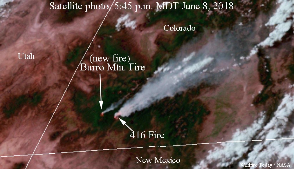
Satellite photo taken at 5:47 p.m. MDT June 8, 2018 showing smoke from the 416 Fire and the Burro Mountain Fire.

Friday afternoon at 4 p.m. a new fire broke out northwest of the 416 Fire near mile marker 34 on HWY 145 . It is named the Burro Mountain Fire and at 5:47 p.m. MDT smoke from the fire was visible on a satellite photo. At 7 p.m. the San Juan National Forest was in the process of issuing closure orders for this fire.

Todd Pechota’s Type 1 Incident Management Team will assume command of the 416 Fire at 6 a.m. Saturday.

Map 416 Fire
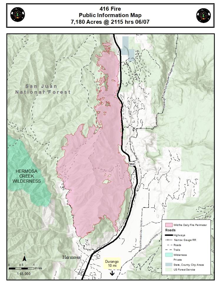
Map of the 416 Fire at 9:15 p.m. MDT June 7, 2018.

Thanks and a tip of the hat go out to Bean.
Typos or errors, report them HERE.

More information released about near miss on Horse Park Fire

Above: The truck that became stuck as the driver attempted to turn it around. The report describes it as “fire damaged”. Photo from the report.

The U.S. Forest Service and the Bureau of Land Management have released more details about the near miss that occurred on the Horse Park Fire May 27 in a remote area of Southwest Colorado. The report disclosed that in addition to the two firefighters that had to flee from a stuck truck, a lookout in another location also fled on foot and ignited an escape fire at a potential fire shelter deployment site as the fire approached. According to the information released there were no injuries.

Below is the narrative from the “72 Hour Preliminary Report”:


“Two crew members were scouting a road for a potential burnout operation when their truck became stuck. They were unable to free the truck before the fire began to overtake them. The crewmembers made the decision to abandon the truck and take their gear with them. They fled back down the road and away from the fire. One crew member ran ahead and made it safely back to the other vehicles. The other crew member dropped his pack, keeping his fire shelter and radio with him. An additional crew member came up the road on a UTV to help him escape. The pair drove to the parking area where the other crew members were waiting in the vehicles.

“Meanwhile, the crew lookout was forced to flee from the lookout position by the same advance of the fire. Given the fire behavior, the lookout did not feel it was possible to outpace the fire and make it back to the vehicles, so instead moved down and away from the fire. The lookout dropped their pack, but kept the fire shelter, a tool, and radio. At some point during the escape, the lookout realized that the antennae was no longer attached to the radio and there was no way to communicate with the crew or other resources. After moving a considerable distance down a drainage, the lookout found a grassy spot that appeared suitable to deploy a shelter, and began lighting the fuels in the area. Before deployment was necessary, aerial resources located the lookout, who was picked up and flown back to the parking area to rejoin the crew.

“There were no injuries as a result of this incident. An Interagency FLA team, is in place and reviewing the incident.”

firefighter's burned pack Horse Park Fire
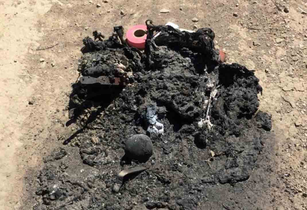
A firefighter’s burned pack. Photo from the report.

Videos recorded during the incident show firefighters hurriedly moving to safety while a radio conversation can be heard referring to the firefighters who escaped and the vehicle that was damaged.

All articles on Wildfire Today about the Horse Park Fire.

Thanks and a tip of the hat go out to Tom.
Typos or errors, report them HERE.

Strategic withdrawal on the Horse Park Fire in Colorado

Above: screenshot from the Hotchkiss Fire District video.

(UPDATE at 6:38 a.m. MDT May 31, 2018)

The Bureau of Land Management has released a 24-Hour Preliminary Report indicating that during initial attack on the Horse Park Fire in southwest Colorado May 27, 2018 a command vehicle was abandoned and is thought to be a total loss. The driver was turning around when the vehicle got stuck. Due to the advancing fire, the driver and passenger had to flee on foot. There were no reports of injuries.

In the second video below (at 0:06) you can hear a radio conversation about losing a vehicle but the firefighters made it out.

****

Originally published at 10:53 a.m. MDT May 29, 2018.

In the three days since the Horse Park Fire started in Southwest Colorado it has burned about 1,500 acres. It’s not a huge fire yet but at times has shown some pretty aggressive fire behavior for the month of May in Colorado.

In the two videos below shot May 27 and posted by the Hotchkiss Fire District you can see that in spite of the date on the calendar firefighters were forced to make a strategic withdrawal when the rapidly spreading fire started moving in their direction.

Warning: the second video has some coarse language as firefighters are being encouraged to relocate.

The Horse Park Fire is burning at about 8,000′ in a very remote area 15 miles southwest of Norwood and 40 miles west of Telluride. Jay Esperance’s Type 2 Incident Management Team has arrived and will in-brief at 10 a.m. today.

Horse Park Fire map
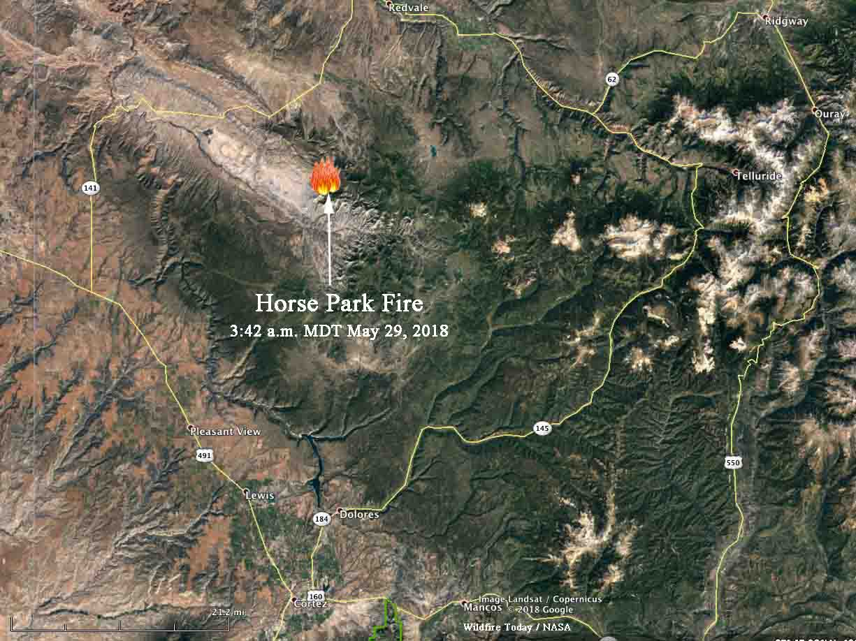
Map showing the location of the Horse Park Fire in southwest Colorado at 3:42 a.m. MDT May 28, 2018. Click to enlarge.

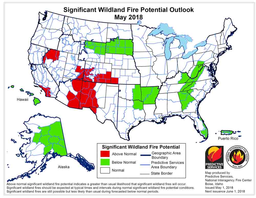
Above normal wildfire activity for most of Southern Colorado was predicted when the latest Wildland Fire Potential Outlook was released by the National Interagency Fire Center on May 1. At that time the conditions were expected to continue through June in Colorado. We should have an updated outlook on June 1.

wildfire potential May
Issued May 1, 2018.

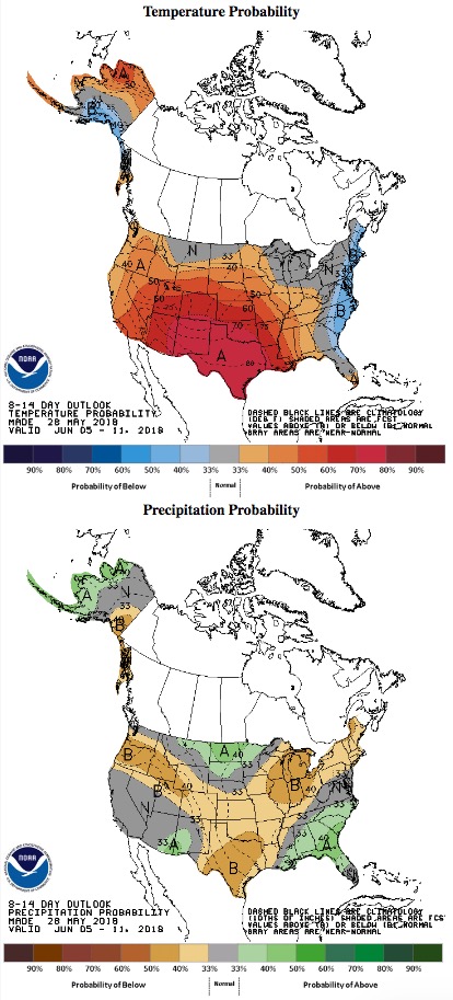
Below are the temperature and precipitation outlooks for June 5 through 11.

temperature precipitation outlook

Officials confirm 23 homes destroyed in 117 Fire

Firefighters have slowed the spread of the 41,000-acre “MM 117 Fire” between Colorado Springs and Pueblo. The name comes from the mile marker on Interstate 25 near the point of origin.

The early reports indicated that 10 structures had burned, but officials have revised that to 23 residences, with 7 of them being unoccupied.

The state requested the Rocky Mountain Area Type 2 Incident Management Team Black, with Incident Commander Mark Hatcher, to manage the fire. They assumed command at 6 a.m. today (Thursday).

When the fire started Tuesday the wind was far too strong for any aircraft to assist firefighters, but Wednesday brought more favorable conditions allowing several contract air tankers and military helicopters to drop retardant and water.

Map 117 Fire
Map of the 117 Fire, April 19, 2018.


Time-lapse of Colorado fires detected by satellite

Posted on Categories UncategorizedTags ,

This is a time-lapse of wildfires in southeast Colorado detected by the fire temperature sensor on the GOES 16 satellite between 1700 UTC April 17 and 0400 UTC April 18. The fire near the arrow is the 117 Fire between Colorado Springs and Pueblo. At the lower right a fire can be seen burning from Colorado into Stanton and Morton counties in Kansas. Several other fires can also be seen. The fires were pushed by very strong winds that stirred up clouds of dust.