A firefighter was killed in Colorado last week after he diverted to suppress a fire while he was traveling to attend the funeral of another firefighter.
Larry Wyant of Joes Volunteer Fire Department was attempting to suppress a fire in a cornfield on October 26 about 120 miles east of Denver, Colorado while the firefighters faced a 30 mph wind gusting to 60 mph. Mr. Wyant was out of his truck when the fire burned over his location. He passed away at the scene.
Our sincere condolences go out to Mr. Wyant’s family, friends, and co-workers.
Larry Wyant fatality notification. US Fire Administration, October 29, 2021.
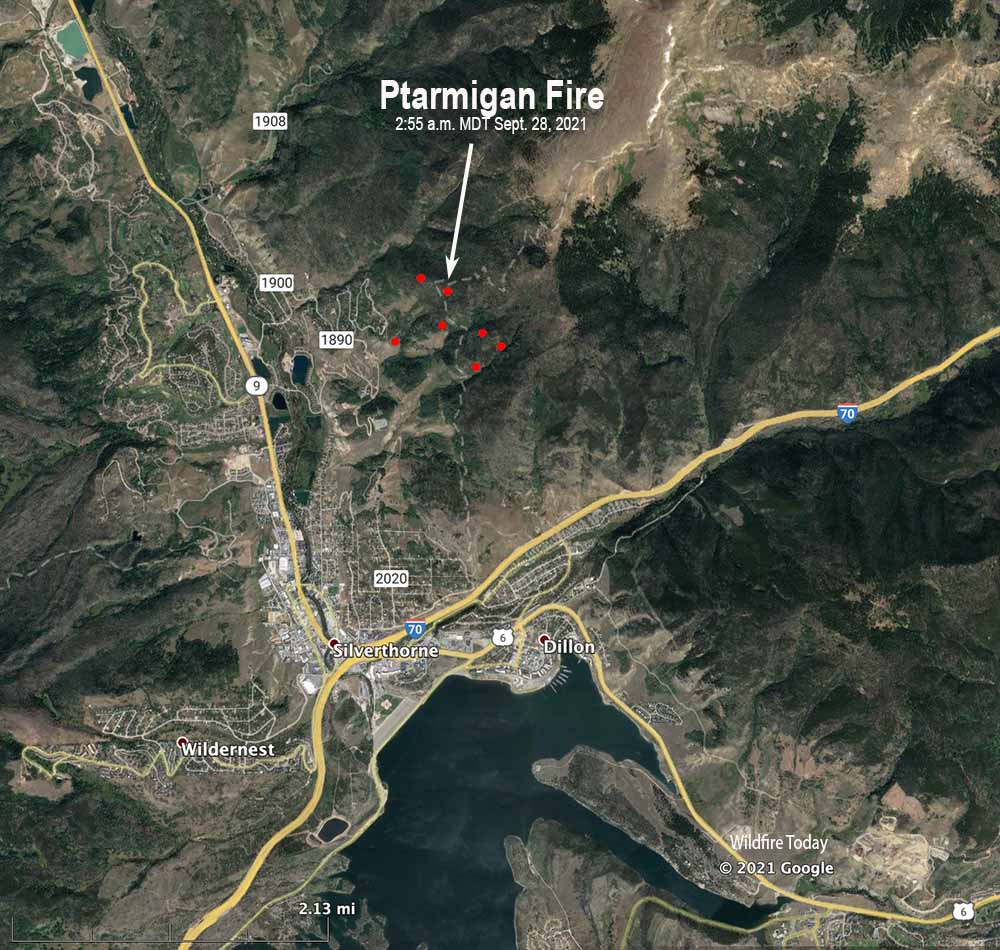
At an 11 a.m. briefing on Tuesday fire officials said the Ptarmigan Fire near Silverthorne, Colorado has prompted the evacuation or pre-evacuation notices of 617 homes.
More accurate mapping Monday evening found that at 10 p.m. the fire had burned about 17 acres, a decrease from the earlier estimate of 30 to 40 acres. The District Ranger said it may have grown to about 40 acres overnight.
Firefighters expect to use tactical firing operations to help protect structures on the west side of the fire. Two hand crews are en route.
The weather forecast predicts significant rain beginning after noon on Tuesday, continuing off and on through Saturday, accumulating about 0.70 inch. The elevation is over 9,000 feet so by Wednesday night it could turn to snow as temperatures drop into the low 30s.
7:45 a.m. MDT Sept. 28, 2021
Ptarmigan Fire map. The icons represent heat detected by satellites as late as 2:55 a.m. MDT Sept. 28, 2021.
The Ptarmigan Fire discovered at about 4:45 p.m. Monday has prompted the evacuation of 200 residents near Silverthorne, Colorado about 50 miles west of Denver. The blaze estimated at 30 to 40 acres is burning on the lodgepole and aspen-covered slopes below Ptarmigan Peak off I-70 north of Dillon Reservoir.
Monday night the Summit County Sheriff ordered mandatory evacuations for the Hamilton Creek area above Silverthorne. Pre-evacuations are in place for Angler Mountain and South 40.
Ptarmigan Fire Sept. 27, 2021. Photo provided by USFS.
The fire was attacked by two single engine air tankers, a large BAe-146 air tanker, and a Chinook helicopter which can carry up to 3,000 gallons. The aircraft focused their efforts on keeping it from moving downhill toward structures.
Monday night the White River National Forest said firefighters had not yet been able to safely engage the fire on the ground, but they are staged in strategic places should they have the opportunity. More resources are en route.
Ptarmigan Fire Monday night. Photo provided by USFS.
Check out the fuels in these photos by Sean Gorman.
Saw what I thought was an aggressive camp fire hiking Ptarmigan. Went to go check it out and was too big to smother. Sadly now looking significant. 911 said crews were in route. #ptarmiganfirepic.twitter.com/K1XEEx51Mw
An Air Tanker drops on the Oil Springs Fire to protect a natural gas plant south of Rangely, CO. The retardant did not cover the plant. Posted 6-23-2021 on InciWeb.
Colorado has six wildfires larger than 500 acres. The fires have not been extremely active over the last couple of days and there is a chance of thunderstorms over most of the western part of the state through the weekend.
Oil Springs Fire, 11,933 acres, 18 miles south of Rangely. The Great Basin Incident Management Team 3 assumed command of the fire at 6:30 a.m. on June 22. Firefighters are still seeing active fire behavior due to dry conditions, receptive fuels and wind.
Muddy Slide Fire, 4,056 acres, 22 miles south of Steamboat Springs. The Rocky Mountain Area Type 2 Incident Management Team Blue assumed command of the Muddy Slide Fire at 6:00 a.m. Thursday. Evacuation information is available HERE. On Thursday, the fire area is forecast to receive afternoon showers, thunderstorms, and increased moisture, reducing fire behavior in the short-term, giving firefighters an opportunity to safely engage the fire.
Sylvan Fire, 3,752 acres, 12 miles south of Eagle. The Rocky Mountain Type 1 Incident Management Team, with Dan Dallas as Incident Commander assumed command of the fire at 6 a.m. Thursday. On the east side of the fire, crews are focusing on working from Sylvan Lake to the west creating a direct fireline from the lake to the power line road. On the west side firefighters are completing direct fireline on the southeast corner where the fire has crossed the Mount Thomas Trail.
West Fire, 3,401 acres, 41 miles southeast of Rock Springs, Wyoming on the WY/CO border. On Thursday crews are securing and strengthening fire lines on all sides of the fire. Unburned fuel inside containment lines will continue to burn and may produce smoke that will be visible as these interior pockets of fuel continue to burn inside established fire lines.
Trail Canyon Fire, 881 acres, 10 miles northwest of Red Mesa. The spread of the fire has been stopped.
Wild Cow Fire, 553 acres, 26 miles north of Fruita. The fire is being managed by Ross Wilmore and the Upper Colorado River Type 3 Incident Management Team. Not much additional information is available.
Map showing heat detected by satellites on the Muddy Slide Fire at 3 a.m. MDT June 23, 2021.
The Muddy Slide Fire 21 miles south of Steamboat Springs, Colorado has burned approximately 3,000 acres at elevations ranging from 8,300 to 10,000 feet. A few decades ago forests at these elevations were too wet to burn frequently. Last year and this year we have seen it happening on a number of fires. Right now the 3,500-acre Sylvan Fire is burning above 9,000 feet 13 miles south of Eagle, Colorado.
Mandatory evacuations have been ordered on the Muddy Slide Fire for residents on County Road 16 between mile markers 12 and 21.
The fire was very active Tuesday spreading south and southeast with crowning, wind driven runs, and long-range spotting. It continued to burn actively throughout the night.
The Rocky Mountain Blue Type 2 incident management team has been ordered. Tuesday evening firefighting resources assigned to the fire included 3 hand crews, 4 engines, and 4 helicopters, for a total of 101 personnel. An additional eight hand crews are on order.
Smoke from the Muddy Slide Fire as seen from the Incident Command Post at 8 p.m. June 22, 2021. InciWeb photo.
Satellite photo, Colorado Fires at 6:15 p.m. MDT June 21, 2021. NASA.
The satellite photo above taken at 6:15 p.m. MDT Monday shows the three large wildfires in northwest Colorado were very active at that time, with large plumes of smoke blowing off to the southeast.
10:16 a.m. MDT June 21, 2021
Satellite photo of smoke from wildfires in Northwest Colorado and Northeast Utah at 6:36 p.m. MDT June 20, 2021. NASA.
Strong winds on Sunday caused four wildfires in northwest Colorado and northeast Utah to grow substantially. They are all in mountainous areas between 7,000′ and 9,400′. The three fires in Colorado listed here were all described as exhibiting extreme fire behavior. It is early in the year to have multiple large fires in Colorado. They are all in remote areas with difficult access and have the potential to continue to expand.
According to information available Monday morning there were a total of 84 personnel assigned to the four fires, which included one hand crew. With nearly 8,000 already committed to numerous fires in Arizona, Utah, New Mexico and other states, it could cause a person to wonder about the availability of firefighting resources as we get deeper into the traditional fire season.
Oil Springs Fire
The largest of the four fires we’re looking at today is the 5,000-acre Oil Springs Fire in Colorado which has prompted evacuations. It has forced the closure of Highway 139 43 miles north of Grand Junction and 26 miles south of Rangely. Structures and oil and gas infrastructure are threatened. It is burning at elevations up to 7,400 feet. Winds gusting at 25 to 39 mph Sunday while the relative humidity was in the single digits resulted in the fire spreading several miles to the southeast and crossing Highway 139. A Red Flag Warning is in effect for the area just south of the fire. The wind is expected to decrease Monday but the RH will be in teens in the afternoon. Resources assigned to the fire Sunday evening included 3 engines, no hand crews, and no helicopters for a total of 20 personnel. A Type 2 Incident Management Team has been ordered. There are two other smaller fires 8 to 10 miles east of the Oil Springs Fire.
Sylvan Fire
The Sylvan Fire is burning above 9,000 feet 13 miles south of Eagle, Colorado just west of Sylvan Lake. The strong wind on Sunday pushed it about two miles to the southeast while exhibiting extreme fire behavior. Using early Monday morning heat sensing data from a satellite it appears to have grown to approximately 800 acres. As of Sunday evening there were no firefighting resources on the fire.
West Fire
The West Fire is 41 miles southeast of Rock Springs, Wyoming on the Wyoming-Colorado border three miles east of the Utah border. It is burning at elevations up to 9,400 feet. The early Monday morning heat sensing data indicates it has burned about 1,700 acres. Structures, oil and gas infrastructure, and sage grouse habitat are threatened. Resources assigned to the fire Sunday evening included 1 hand crew, 3 fire engines, and 1 helicopter for a total of 64 personnel.
West Fire. Photo by Moffat County Sheriff’s Office June 20, 2021.
Sego Fire
The lightning-caused Sego Fire is in a very remote area of Utah 52 miles east of Price in rugged, difficult to access terrain. Smoke from the fire is very visible on the satellite photo at the top of this article. Heat sensing data indicates it had burned approximately 500 acres by early Monday morning.
Map of fires in Northwest Colorado and Northeast Utah. The red areas indicate heat detected by satellites at 3:42 a.m. MDT June 21, 2021.
The Associated Press is reporting that a wildland firefighter died Wednesday night in Mississippi.
Evan Batson, 34, worked for the U.S. Forest Service in Colorado on the San Juan National Forest’s Columbine Wildland Fire Module. The crew was on an assignment in Mississippi assisting with prescribed fires.
Mr. Batson and his co-workers had gone to dinner in Natchez. They were walking to a casino when he jumped a fence to take a shortcut from the top of a bluff to a grassy area, but he jumped too far. Natchez Police Department Cmdr. Scott Frye said the drop was about 100 feet down.
His co-workers, some of whom are EMTs, administered first aid along with the Natchez Fire Department.
“There was no motor vehicle access where he was,” Police Chief Joseph Daughtry said.
Later Mr. Batson was pronounced dead.
“His death occurred outside of work hours and is still under investigation,” said Lawrence Lujan, a spokesman for the US Forest Service. “Evan worked on the Payette, Medicine Bow-Routt, Manti La Sal, and San Juan National Forests as a career wildland firefighter during his tenure. We share this profound loss with Evan’s family, friends, and crew members and hold them in our thoughts and prayers during this difficult time.”
“The Columbine Wildland Fire Module (WFM) is a ten-person crew based out of the Columbine Ranger District of the San Juan National Forest. Columbine WFM is a resource that responds to fires locally, regionally, and nationally, and provides self-sufficient, highly skilled fire professionals to assist with wildland and prescribed fire operations, fire behavior and fire effects monitoring, hazard fuels reduction, and a range of other fire and resource related missions. Columbine has existed as an “initial attack” module since the early 2000s. With support from Forest Leadership working to expand the San Juan National Forest’s managed and prescribed fire programs, Columbine was reborn as a Wildland Fire Module in 2013.”
File photo of the Columbine Wildland Fire Module. USFS photo.
Our sincere condolences go out to Mr. Batson’s family, friends, and co-workers.
Thanks and a tip of the hat go out to Mike and Scott.