DC-10 air tanker to visit airports in Minnesota, South Dakota, and Montana

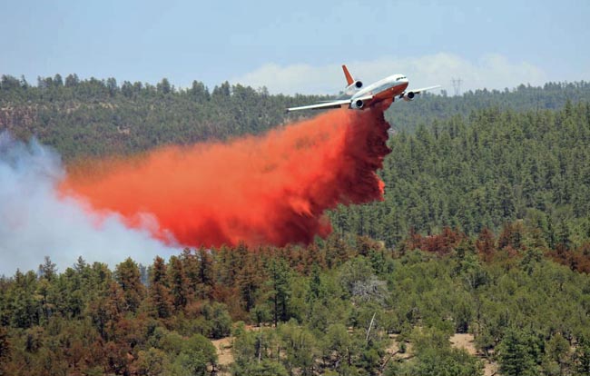
Tanker 911 dropping Poco Fire
Tanker 911 dropping on the Poco Fire in Arizona, June 15, 2012. Photo by Ian James.

UPDATED at 12:19 p.m. Monday, April 22, 2013:

The schedule for the visits of Air Tanker 910 to airports in Minnesota, South Dakota, and Montana described below has been revised due to snow at Rapid City — everything is being pushed by 24 hours. More details at Wildfire Today.

****

One of the DC-10 Very Large Air Tankers will visit airports in Minnesota, South Dakota, and Montana next week. Air Tanker 910, owned by 10 Tanker Air Carrier, has been in Michigan undergoing heavy maintenance in recent weeks and will leave from there Monday morning, April 22 and head west. On their way home in southern California, their plans are to stop at four cities:

  1. Brainerd, Minnesota, Monday morning;
  2. Rapid City, South Dakota, early Monday afternoon;
  3. Billings, Montana, Tuesday;
  4. Missoula, Montana, Tuesday.

If a DC-10 reloaded at Rapid City it would have to be from a portable retardant base, since it is unlikely that the existing rather cramped Tanker Base could support such a large aircraft, and possibly the weight would be more than the ramp could handle. Rick Hatton, President of 10 Tanker Air Carrier, told us that if they worked out of Brainerd the aircraft would most likely drop water, rather than retardant. Finding a fire hydrant within reach of the three-inch diameter hose the aircraft carries can be easier than accessing a Tanker Base.

The DC-10 always carries 11,600 gallons of fire retardant, about six times more than the 50+ year old Korean War vintage P2V “legacy” air tankers that drop an average of 1,948 gallons according to a 2007-2009 air tanker study.

The U.S. Forest Service has awarded exclusive use contracts for seven P2Vs and one BAe-146 air tanker for 2013. The agency has not yet announced any awards from the solicitation for “next-generation” air tankers they issued 505 days ago. There are indications they will give contracts to 7 next-gen air tankers, bringing the total number of air tankers to 15 for this year. In 2002 there were 44 large air tankers on exclusive use federal contracts. The USFS has said they may again borrow, if needed and available, some old CV-580 air tankers from Canada for a few months that carry 2,000 gallons of fire retardant. The CV-580s were produced between 1947 and 1954.

Southern California brush fire in San Gabriel Canyon

Williams Fire, Sept 2, 2012
Williams Fire, Sept 2, 2012. Photo by 10 Tanker Air Carrier

The Williams Fire started in San Gabriel Canyon north of Azusa in southern California Sunday afternoon and through the afternoon and evening grew to 3,600 acres. The origin was between Camp Williams and the shooting range along East Fork Road in San Gabriel Canyon about 3.5 miles east of Highway 39. A map showing the location of the Williams fire is below.

Map of Williams Fire Sept 2, 2012. MODIS
Map of Williams Fire. The red circles represent the location of heat detected by a satellite. Sept. 2, 2012. MODIS (click to enlarge)

San Gabriel Canyon, which will be closed on Monday, Labor Day, typically sees over 10,000 visitors on a holiday weekend.

At least 300 personnel are assigned to the fire, as well as 9 air tankers, 4 helicopters, 30 engines, 2 dozers, and 4 hand crews. It is moving north through very steep terrain toward the Sheep Mountain Wilderness area. As of 2 a.m. Monday morning the fire was listed as 5 percent contained.

All of the photos below were taken by the crew on Air Tanker 911, a DC-10 which earlier on Sunday was repositioned from Casper, Wyoming where it had been based while working the fires in Nebraska, to Sacramento. From Sacramento it was dispatched to this fire, and Sunday night was at San Bernardino. The second DC-10, T-910, was recently released from their Call When Needed contract and sent home.

Williams Fire
Williams Fire, Sept 2, 2012. Photo by 10 Tanker Air Carrier

The LA Times has a nice collection of photos of the fire.

Update on Nebraska’s Region 23 fires

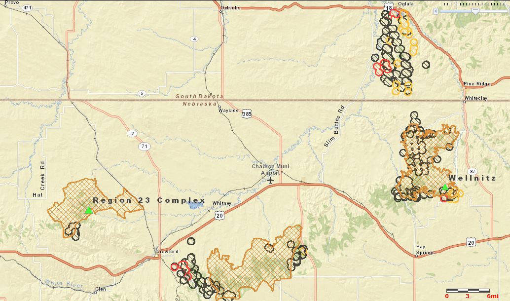
map of Nebraska and South Dakota fires, 122 am MT, Sept 2, 2012
Map of fires in northwest Nebraska and southwest South Dakota, 1:22 a.m. MT, Sept 2, 2012. The brown cross-hatched areas are the latest fire perimeters uploaded by the Incident Management Teams. The small circles represent heat detected by a satellite in the last 24 hours, with the red and yellow circles being the most recent. GEOMAP and MODIS. (click to enlarge)

Firefighters are making progress on the two large fires in the Region 23 Complex that are south and west of Chadron, Nebraska, comprised of the Douthit Fire northwest of Crawford and the West Ash fire southeast of Crawford and south of Chadron.

The Chadron Record reported that Incident Commander Joe Lowe said in a public meeting Friday that the Douthit Fire has a control line around it but could still be susceptible to growing larger if strong winds become a problem.

The Chadron Record also had this interesting bit of information:

Crow Butte [uranium] Mine near Crawford has also been shut down and evacuated, and Lowe said the team is strategizing how to handle the potential hazardous material situation should the fire advance that far. The blaze is currently three to four miles from the mine.

The more active of the two fires, the West Ash Fire, has come close to Highways 385 and 20, requiring the temporary closure of 385. One of the DC-10 air tankers dropped at least three 10,600-gallon loads of retardant near the highways.

The Wellnitz Fire northeast of Chadron has burned about 60,000 acres in Nebraska and South Dakota.

The information below about the Region 23 Complex was sent to us at 10 p.m. September 1 by Beth Hermanson, Public Information Officer for the Rocky Mountain Incident Management Team C:

==============================================================

Region 23 Fire Complex has burned 87,555 acres and is 47% contained as of this evening.  Significant progress was made on the Douthit Fire today, while West Ash remains active.

The Douthit Fire crews took advantage of yesterday’s temperatures to complete burnout operations to help secure containment lines. Firefighters worked on constructing and strengthening line, and focused mop up around structures and near the fire line, while mitigating risks.

The West Ash Fire remained active as firefighters worked on constructing and strengthening fire lines which were tested throughout the day by high erratic winds. Significant indirect efforts to provide extra protection to the city of Chadron were completed, including drops from the DC-10 Very Large Air Tanker, (VLAT) of 36,000 gallons of retardant, and heavy equipment completed lines around each home.

Near Crawford, fire officials successfully completed a five-mile burnout operation to help reinforce containment lines.

Resources continued to arrive throughout the day, with a reported 658 personnel now dedicated to the Region 23 Complex.  To date, there have been no firefighter injuries.

Fire crews anticipate a busy night operational period with changing weather conditions.  A cold front is expected to move in this evening, likely preceded by strong erratic winds and a thunderstorm.  The Incident Management Team prepared by staffing a significantly larger night operation shift.  Crews plan to take advantage of the predicted cooler temperatures and increased relative humidity to make significant progress on containment, and to continue burnout operations.

EVACUATIONS:  Fire and Law Enforcement Officials strive to return evacuees’ home as soon as possible; meanwhile the following evacuations continue mandatory, including:

Residents living west of Highway 385, and south of Highway 20, Highway 385 to Hawthorne Road and all areas north of Buttermilk Road to Highway 20; including Country Club Road, Old County Club Road, and Goffena Road.  This also includes Deadhorse Road to Table Road and Flag Butte Road.

Residents living on Highway 385 between Chadron City Dams and Red Cloud Camp area, both the east and west side.

Crawford area residents living from the West Ash Road south on Highway 2 for five miles, across Breakneck Road, east to West Ash Creek Road; including West Ash Creek Road, Squaw Creek Road, Saw Log Road, Horseshoe Road, Breakneck Road, Dyer Road and Crow Butte Road.

The Village of Whitney remains evacuated.

Update on fires in northwest Nebraska and southwest South Dakota

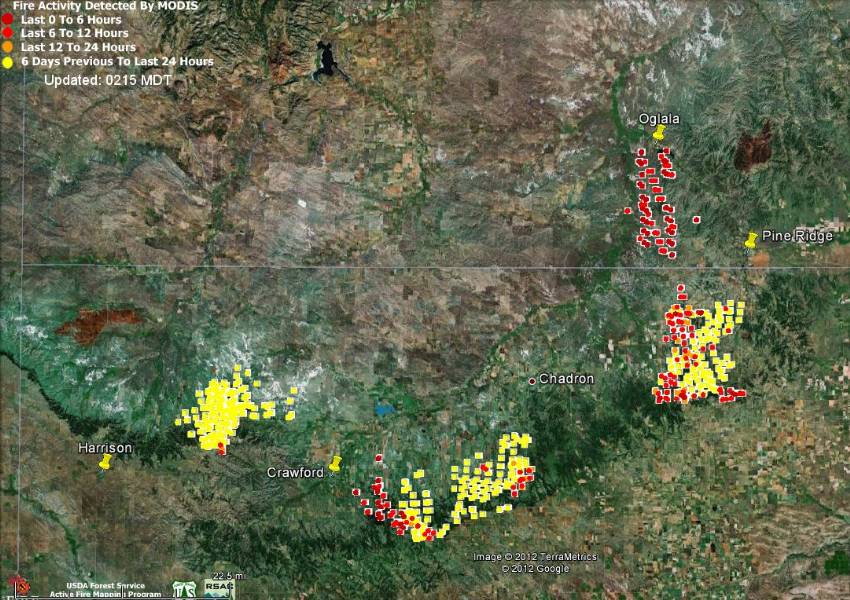
Northwest Nebraska and southwest South Dakota fires
Northwest Nebraska and southwest South Dakota fires, 10:01 pm MT, August 31, 2012 (click to enlarge)

UPDATE at 11:47 a.m. MT, September 1, 2012:

What we thought were four major fires in the northwest Nebraska and southwest South Dakota areas are actually three. The large fire near east of Chadron, northwest of Pine Ridge, and south of Oglala, named Wellnitz, is just one VERY large fire that burned from Nebraska into South Dakota. If you notice the gap in the heat icons at the white SD/NE state line southwest of Pine Ridge, the fire must have burned very quickly through some light vegetation and burned out, between passes of the heat-sensing satellite. The MODIS satellite passes over most areas of the world two to three times a day on an irregular schedule.

The two fires nearest Crawford are part of the Region 23 Complex. Here is an update from InciWeb, which was updated at about 12:30 p.m. MT today:

More than 68,689 acres have burned in the Region 23 Complex fire in northwest Nebraska accordingto Rocky Mountain Incident Management Team C officials.

The complex consists of two fires the West Ash Fire near Chadron and the Douthit Fire near Crawford. The fires started by lightning, Aug. 28. Containment of the fires is estimated at 25 percent. West Ash accounts for 44,354 acres and the Douthit fire has burned 24,335 acres. The fires did not grow overnight.

The fires are in rugged inaccessible terrain burning ponderosapine and grass. Red flag warning is expected to continue,possibly for the next three days. Fire fighters worked through the night preparing areas of the fire likely to be affected by potential high winds over the next couple of days.

The InciWeb site also has information about evacuations.

Five Nebraska National Guard helicopters are assisting with the fires. Models being used include CH-47 Chinook, UH-72 Lakota, and UH-60 Blackhawk.

The weather in the area is very conducive to rapid fire spread. A weather station south of Chadron at 11:22 a.m. today recorded a temperature of 89, relative humidity of 13 percent and a wind speed of 21 gusting to 40 mph.

One of the DC-10 very large air tankers dropped retardant on the fires today and yesterday, and is most likely reloading at Casper, Wyoming with 10,600 gallons of retardant with each flight. Casper is 133 miles from the fire near Harrison, not a long flight when cruising at more than 500 mph. The aircraft dropped three loads of retardant Friday and Saturday on the West Ash fire, totaling approximately 34,000 gallons.

Neptune’s Tanker 40, a jet-powered BAe-146, filed a flight plan to travel from Missoula to Rapid City, and is expected to arrive there at about 3:30 MT today. It is likely that it will also be working on these fires. Maybe someone will send us a photo of it or the DC-10 assisting the firefighters on the ground.

=======================================================

Originally posted at 4:06 a.m. MT, September 1, 2012

We will write more about this later, but  now there are four major wildfires burning in northwest Nebraska and southwest South Dakota. The MODIS heat sensing satellite is showing detections in a new area in South Dakota, south of Oglala and northwest of Pine Ridge.

We had more information about the Nebraska fires earlier, including a fatality that may be related to the fires, and Inciweb has information about evacuations.

DC-10 air tankers have dropped more retardant than the MAFFS C-130s

Two, DC-10 air tankers
10 Tanker Air Carrier’s two DC-10 Very Large Air Tankers. Photo: 10 Tanker

The two DC-10 air tankers operated by 10 Tanker Air Carrier have dropped more retardant this year than the seven to eight Modular Airborne FireFighting System (MAFFS) C-130 aircraft flown by the military. The DC-10s have dropped, according to 10 Tanker, 2.408 million gallons through August 27 during 215 flights for an average of 11,200 gallons per flight.The MAFFS, according to the August 29 Government Security News, have dropped 2.153 million gallons through August 24, employing 899 flights to do so. This indicates an average of 2,394 gallons per flight for the MAFFS aircraft.

The DC-10s have a Call When Needed contract with the U.S. Forest Service and are only activated when the USFS decides to use them. This year one of them, Tanker 911, was called up (these dates are approximate) June 11 and released on June 16. It was reactivated around August 3 and the second DC-10, Tanker 910, was put on active duty on approximately August 7.

One of the eight MAFFS C-130s crashed July 1, 2012 while dropping on the White Draw fire west of Hot Springs, South Dakota, killing four crewpersons and injuring two. While the military has many C-130s, there were only eight of the second generation MAFFS2 units which can be loaded into the cargo hold of the aircraft making it possible for it to hold up to 3,000 gallons of fire retardant. And of course the crew can’t be replaced, only substituted.

CAL FIRE reports 43 more homes burned in Ponderosa Fire

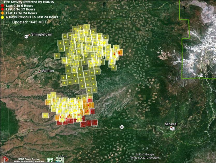
Map of Ponderosa Fire, 2:15 p.m. PT, August 21, 2012
Map of Ponderosa Fire, showing heat detected by a satellite at 2:15 p.m. PT, August 21, 2012. MODIS/Google (click to enlarge)

(Updated at 6:48 p.m PT, August 21, 2012)

The Ponderosa Fire, 22 miles northeast of Red Bluff, California, has grown to 21,506 acres as of Tuesday afternoon. At 6:15 p.m today CAL FIRE increased the number of structures reported as destroyed to 50, which is 43 more than they reported this morning and yesterday. Another 200 structures remain threatened. The fire is burning in a mix of grass, brush, and heavy timber and is being called 40 percent contained.

The above map shows that as of 2:15 p.m. PT today most of the heat detected by a satellite was on the south side of the fire near Highway 36. Keep in mind that the locations depicted were identified from hundreds of miles above the earth, so there can be errors by up to a mile or so.

The fire continues to burn to the east and south in the Battle Creek Drainage.

The areas that are evacuated were confirmed by CAL FIRE for the following areas in Manton, Shingletown & Viola:

  • Forward Rd at Graham to the C Line
  • Forward Mill Rd from Rock Creek Rd to Forward Camp Rd
  • Rock Creek Rd from Manton Rd to Long Hay Flat Rd
  • All of Long Hay Flat Rd and Woodcutter Way
  • Southside of Highway 44 from Viola to Brush Oak
  • Northside of Hwy 44 from Viola to Alward
  • Hazen Rd area and South Power House Rd south of Manton
  • Hwy 44 at Brush Oak east to and including Viola, Plateau Pines, Starlight Pines and Lake McCumber area
  • South side of Hwy 44 from Viola to Brush Oak and on the north side of Hwy 44 from Viola to Alward

Evacuation warnings have been issued for Hwy 36 from Ponderosa Sky Ranch to Lassen Lodge communities.

Resources assigned to the fire include 2,133 personnel, 278 engines, 38 hand crews, 11 helicopters, and 53 dozers

“TurtleSloth” uploaded this video yesterday showing of one of the DC-10 very large air tankers dropping near Highway 36 on the Ponderosa fire.