Decker Fire grows to over 8,000 acres

Rapid spread of the fire Sunday forced fire crews to escape to a safety zone

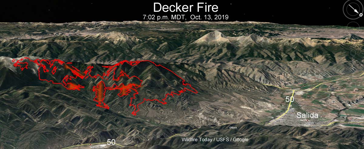
map of the Decker Fire
3-D map of the Decker Fire at 7:02 p.m. MDT Oct. 13, 2019. The red shaded areas represent intense heat. Looking southwest. Click to enlarge.

UPDATED at 10:25 p.m. MDT Oct. 14, 2019

The Decker Fire has ordered nine more 20-person hand crews. They will be Type 2 IA (Initial Attack) crews coming all the way from Oregon.

The weather near Salida is not expected to be extreme through Thursday; the winds will be from the west or southwest at less than 11 to 14 mph but the humidity will be very low — single digits during the day and in the 30s at night. But beginning Friday and through the weekend the wind will increase to the mid-teens with gusts in the 30s. There is a chance of rain or snow on Sunday.

Those crews might be handy to have around on Friday and Saturday, and also to get more line construction and mopup done before the winds arrive.


4:02 p.m. MDT Oct. 14, 2019

The Decker Fire three miles south of Salida, Colorado continues to grow and Sunday put firefighters in a precarious situation. After the fire crossed fire lines on both the east and west sides following three days of Red Flag Warnings firefighters on the northeast side working to stop the spread had to use escape routes to take refuge in safety zones. After taking accountability to ensure all were safe, they reengaged after the fire activity decreased.

(To see all of the articles on Wildfire Today about the Decker Fire, including the most recent, click here.)

More fire crews and aircraft have been requested and new evacuation orders for residents issued.

The 8,118-acre lightning-caused fire has been burning for about five weeks and is being “managed” or herded around, rather than fully suppressed.

For evacuation  information contact the Chaffee County Sheriff’s Office, 719-539-2596, or Fremont County Emergency Management, 719-276-7416, 719-276-7418, or visit the Chaffee County Sheriff or Fremont County Sheriff Facebook pages and websites.

Resources assigned to the fire include: 18 hand crews, 27 fire engines, 4 dozers, 8 water tenders, and 7 helicopters for a total of 707 personnel.
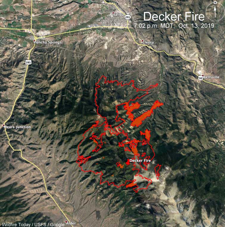
Map Decker Fire
Map of the Decker Fire at 7:02 p.m. MDT Oct. 13, 2019. The red shaded areas represent intense heat.

The video below that shows the smoke column blowing rapidly off to the left is time-lapse, not real time.

Firefighters to conduct aerial ignition operation on the Decker Fire

The fire has burned 6,155 acres south of Salida, Colorado

Above: The west side of the Decker Fire, October 5, 2019. InciWeb.

11:44 a.m. MDT October 6, 2019

Even though the Decker Fire south of Salida, Colorado is not a full suppression fire, quite a bit of fireline has been constructed on the perimeter. However, Mark Giacoletto’s Type 1 Incident Management Team reports that only 5 percent of the fire is contained.

(To see all articles on Wildfire Today about the Decker Fire, including the most recent, click here.)

Most of the recent fire activity has occurred on the west side (see map below). Over the last two days the fire has grown by 331 acres, bringing the total to 6,155 acres.

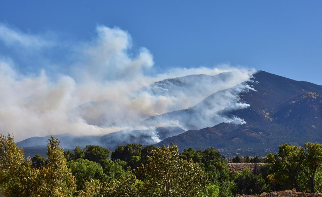
The photo at the top of the article shows that portions of the fire on the west side are creeping into stands of Aspen, which can slow the spread considerably.

map Decker Fire
Map showing the perimeter of the Decker Fire (in red) at 10:08 p.m. MDT Oct. 5, 2019. The white line was the perimeter about 48 hours before.

Residents may see more smoke in the area Monday as fire managers burn out some areas on the east side. The objective is to remove fuel and slow the spread of the main fire. The aerial ignition operation will be conducted from a helicopter.

Resources assigned to the fire include: 23 hand crews, 28 engines, 3 dozers, 6 helicopters, 3 fixed wing aircraft, and 10 water tenders for a total of 806 personnel.

There is now an interactive map available for the Decker Fire at https://arcg.is/1zPGWH. It will allow you to enter your address to see your location relative to the fire, it provides a measuring tool to measure distance, and can give hunters information related to forest closures. The fire perimeter on the map will be updated once a day.

Decker Fire grows to more than 5,800 acres

The fire is about three miles south of Salida, Colorado

Decker Fire
Decker Fire as seen from the north side of Salida, CO October 2, 2019. Photo by John Phillips.

(7:30 a.m. MDT October 4, 2019)

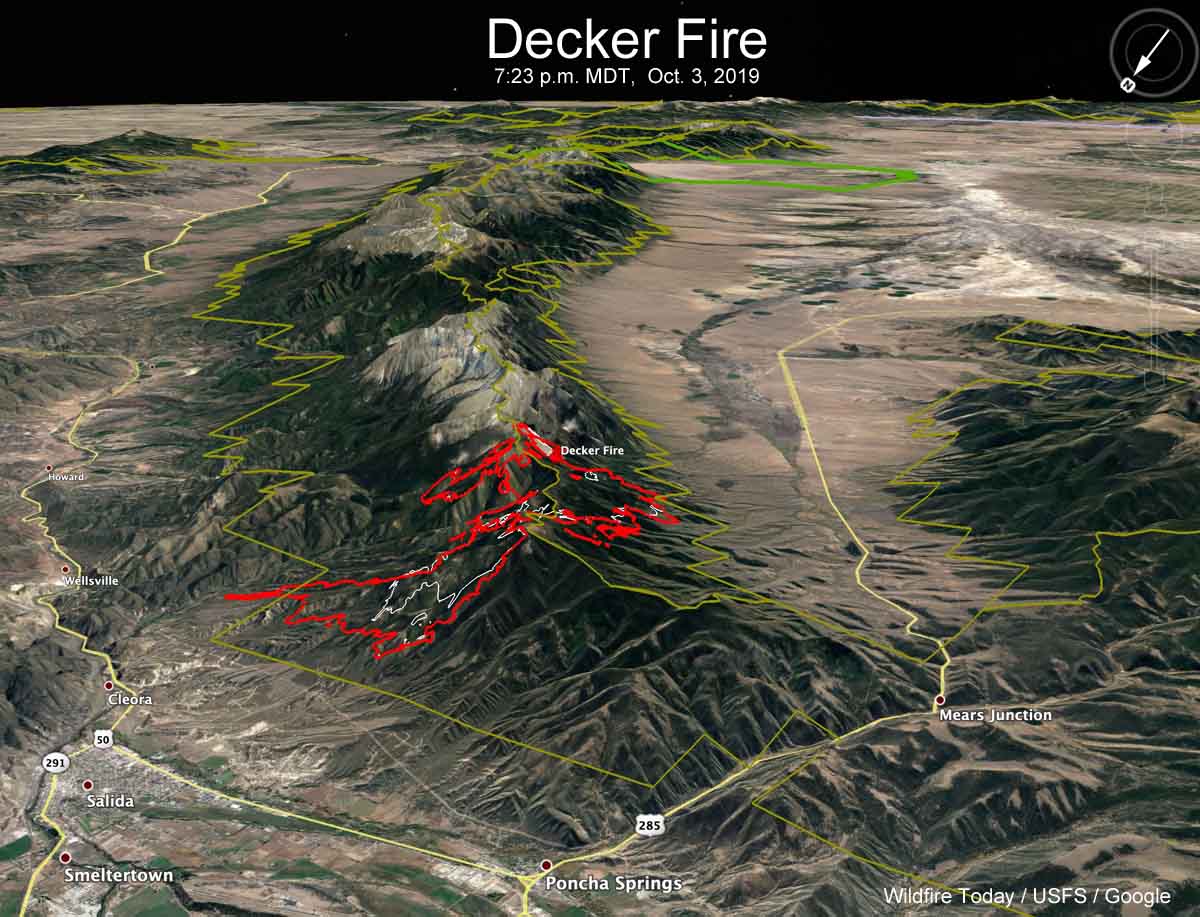
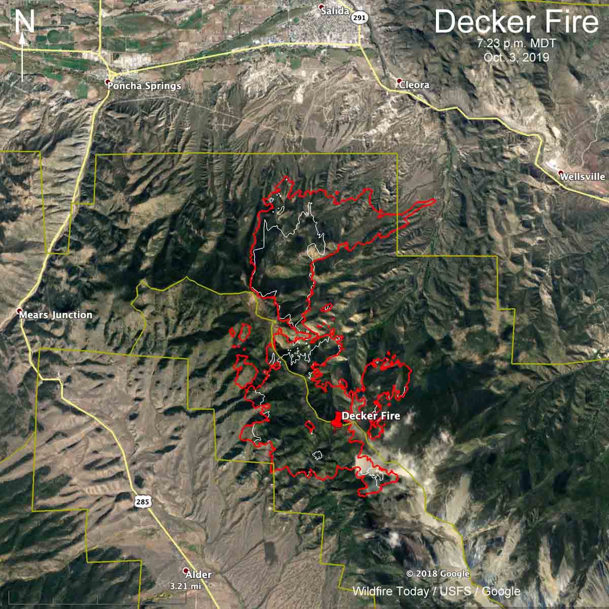
A mapping flight Thursday night found that the Decker Fire south of Salida,  Colorado had grown by 2,078 acres since the previous flight about 48 hours before, bringing the size up to 5,824 acres. Most  of the expansion occurred on the north side bringing it to 2.5 miles south of Highway 50. On the northeast side it spread almost a mile outside the boundary of the Rio Grande National Forest toward Wellsville.

Thanks to higher humidity and calmer winds the fire was not as active Thursday as in recent days (see map below). Instead of the 2 percent relative humidity seen on the fire Wednesday, the minimum reached Thursday was 20 percent.

3-D map Decker Fire
3-D map showing the perimeter of the Decker Fire (in red) at 7:23 p.m. MDT Oct. 3, 2019. The white line was the perimeter about 48 hours before. Looking southeast.

The weather forecast for the north side of the fire calls for 73 degrees  and 15 mph winds  out of the southwest or west on Friday and Saturday. The humidity will be in the teens Friday and single digits on Saturday.

(To see all articles on Wildfire Today about the Decker Fire, including the most recent, click here.)

map Decker Fire
Map showing the perimeter of the Decker Fire (in red) at 7:23 p.m. MDT Oct. 3, 2019. The white line was the perimeter about 48 hours before. The green line is the boundary of the Rio Grande National Forest.

Resources assigned to the fire Thursday evening included 8 hand crews, 10 engines, and 5 helicopters for a total of 458 personnel. Approximately $2.3 million has been spent on managing this less-than-full-suppression fire to date.


We will update this article as more information becomes available.

Smoke forecast for October 3, 2019

Smoke from the Decker Fire west of Colorado Springs will affect areas southwest of Denver

Above: Smoke forecast for 8 p.m MDT October 3, 2019, near surface and vertically integrated.

These maps were generated by NOAA at 6 a.m. MDT October 3, predicting the distribution of smoke. The forecast below indicates that near surface smoke from the Decker Fire south of Salida will be affecting the Denver area as well as locations southwest and north of Denver on Thursday.

smoke forecast Colorado Decker Fire
Forecast for smoke created by the Decker Fire that will be near the Earth’s surface in the Colorado area at 8 p.m MDT October 3, 2019.


Satellite photo of smoke from the Decker Fire

The fire has burned over 4,000 acres south of Salida, Colorado

This satellite photo shows smoke from the Decker Fire Wednesday evening as the lights were starting to be turned on in the Denver and Colorado Springs areas.

The fire has burned approximately 4,000 acres.

More information about the Decker Fire.

Evacuations ordered at the Decker Fire south of Salida, Colorado

Winds on Wednesday caused some movement to the east

Above: Morning briefing at the Decker Fire, October 3, 2019. IMT photo.

(UPDATED at 9:01 a.m. MDT October 3, 2019)

Strong winds gusting at over 25 mph out of the west on Wednesday pushed smoke from the Decker Fire to the east toward Colorado Springs. The wind combined with the relative humidity dipping down to the ridiculously low 2 percent at Salida resulted in the northern portion of the fire to spreading to the east. (see map below)

(To see all articles on Wildfire Today about the Decker Fire, including the most recent, click here.)

There was no fixed wing aircraft mapping flight Wednesday night due to mechanical problems with the plane. The map below shows heat detected by a satellite as late as 3:48 a.m. Thursday, but that data from hundreds of miles overhead is not as accurate as an aircraft 5,000 to 10,000 feet above the ground. So consider the dots that represent heat to be approximate locations. With that in mind, the fire may or may not have approached or crossed the boundary of the Rio Grande National Forest, the green line.

map Decker Fire
The dots represent heat on the Decker Fire detected by a satellite. The most recent heat detected (red dots) was at 3:48 a.m October 3, 2019.. The red line was the perimeter at 1:27 a.m. MDT Oct. 2, 2019.
Satellite photo smoke Decker Fire
Satellite photo of smoke from the Decker Fire just south of Salida, Colorado.
smoke Decker Fire
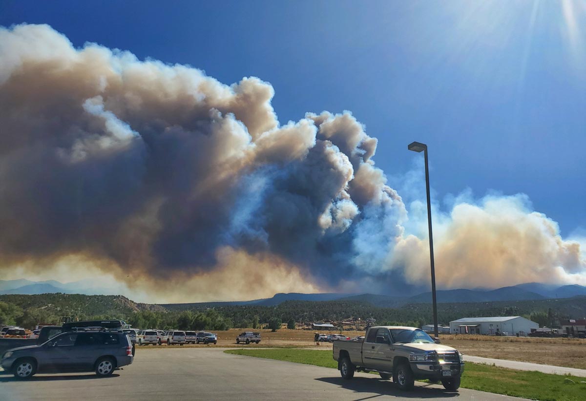
On Wednesday October 2 wind pushed smoke from the Decker Fire to the east. IMT photo.

The Rocky Mountain Type 1 Incident Management Team assumed command of the fire at 7 am. Thursday.

Resources assigned to the fire Wednesday evening included 8 hand crews, 10 engines, and 5 helicopters for a total of 259 personnel. Approximately $1.9 million has been spent on managing this less-than-full-suppression fire to date.

We will update this post as more information becomes available.


(UPDATED at 3:50 p.m. MDT October 2, 2019)

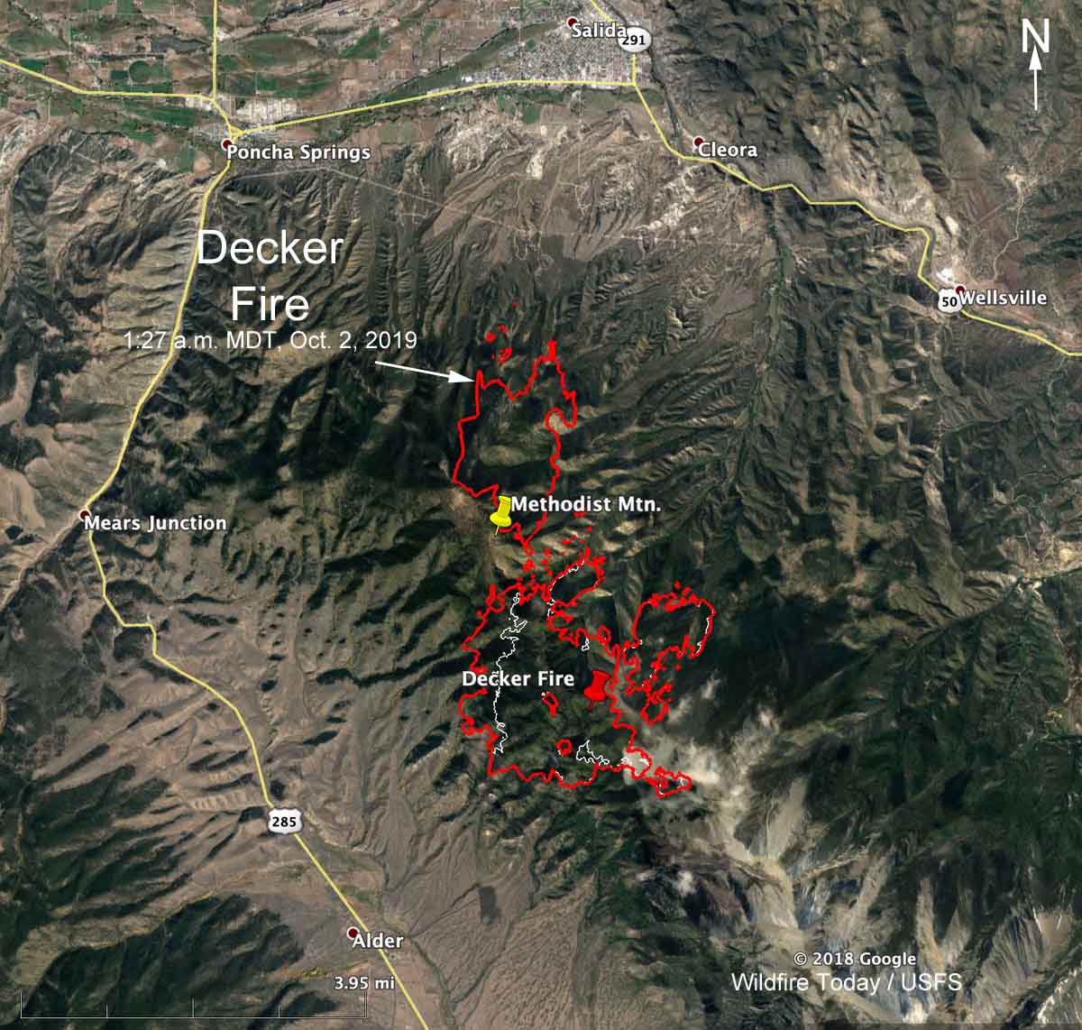
map decker fire colorado
Map showing the perimeter of the Decker Fire 3 miles south of Salida, Colorado at 1:27 a.m. MDT Oct. 2, 2019.  The white line was the perimeter about 24 hours before.

Continue reading “Evacuations ordered at the Decker Fire south of Salida, Colorado”