How drones can better integrate with total incident response

Drone Hovering Over a Burning Forest

By Usama Mehboob

Wildfire drone operations have moved beyond the question of whether an unmanned aircraft can find heat or provide an overhead view. The harder problem is fitting another aircraft and another stream of data into an incident that may already involve helicopters, air tankers, lead planes, ground crews and changing airspace restrictions. For response professionals, useful drone work starts with aviation integration, disciplined mission planning and a clear path from observation to action.

Airspace Coordination Comes Before Sensor Capability

Temporary Flight Restrictions (TFR) around active wildfires are intended to protect firefighting aircraft and crews. Unauthorized drones can interrupt crewed aviation, yet authorized public safety flights still have to fit inside the same incident aviation structure. A technically successful mission can become an operational problem if the aircraft location, altitude or flight window conflicts with a helicopter or tanker assignment.

Authorized drone operations on active wildfires already work within established incident command and aviation structures. The challenge is maintaining that integration as UAS missions become more frequent, longer-range and increasingly complex. A drone may be operating under incident authority, but its flight area, altitude, timing, communications and data requirements still have to remain aligned with changing crewed-aircraft operations throughout the operational period.

For that reason, UAS coordination should extend beyond initial flight approval. Flight areas, altitude limits, lost-link procedures and an immediate grounding process need to be understood before launch and reviewed as incident conditions change. TFR and NOTAM (Notice to Airmen) information can also change during an operational period, so a single preflight review is not enough for a long mission cycle.

Key operating priorities include:

  • Define operating areas and altitude limits before launch.
  • Keep direct coordination between Unmanned Aerial Systems (UAS) personnel and incident aviation staff.
  • Recheck TFR and NOTAM information as conditions change.
  • Give aviation supervisors clear authority to stop unmanned flights when crewed aircraft need the airspace.

Beyond Visual Line of Sight (BVLOS) missions can extend observation beyond practical ground access, but range brings new problems. Communications reliability, aircraft tracking, detect and avoid methods and lost link behavior become part of the safety case. More distance is useful only when the incident team can still account for the aircraft and control the mission.

Drone Over a Smoking Forest Fire
Image created by ZenaDrone

Thermal Imaging Has Limits That Matter on a Fireground

Thermal imaging can support hotspot searches, perimeter assessment and detection of residual heat. The risk is treating a thermal image as a final answer. Vegetation, terrain, sensor angle, smoke, heated surfaces and distance can change what the operator sees. A bright signature may need field confirmation, and hidden combustion may remain difficult to characterize from one aerial pass.

Repeated observations tied to coordinates are often more useful than a single image. The operational question should be simple: what decision will this flight support? A drone that detects heat outside a containment line may provide valuable intelligence. That value drops very quickly if the location remains on the pilot display and does not reach the people assigning resources.

Endurance and Night Operations

Battery endurance is another practical constraint, particularly across large incidents. Published flight time matters less than usable mission time after wind, distance, payload, reserve requirements and repeated recovery cycles are considered. Crews may spend a surprising amount of the operational period managing batteries, charging and launch locations rather than collecting data.

Night flights can support thermal observation during periods of reduced visibility, but darkness changes the risk picture. Terrain references become harder to judge and recovery may require more planning. Night activity still needs to remain coordinated with other aviation. It cannot be assumed that the absence of daylight means the airspace is available.

Data Integration Is the Larger Opportunity

Wildfire agencies already collect large amounts of information. Drones can add thermal images, video, maps and coordinates at a pace that becomes difficult to use. The real objective is not collecting more data. It is moving a smaller amount of verified information to the right person soon enough to influence a decision.

Different agencies may arrive with different mapping platforms, radio systems and data procedures. This can make a simple location report harder to share than expected. Incident teams benefit when drone outputs use common geospatial formats and when responsibility for validating and distributing UAS intelligence is defined in advance.

Autonomous docking stations may make repeated observation easier by supporting automated launch, recovery and charging. They still require reliable communications, weather limits, updated airspace information and a clear way to interrupt a mission when incident priorities change. Autonomy can reduce routine workload, but it does not remove accountability to incident command.

The strongest wildfire use of drones is likely to come from integration rather than aircraft quantity. Better airspace deconfliction, disciplined thermal interpretation, practical BVLOS procedures and interoperable data sharing can make UAS missions more useful without adding unnecessary risk. Wildfire response does not need drones flying simply because they are available. It needs missions with a defined purpose, controlled access to the airspace and a direct connection between observation and action.

Usama Mehboob is a Content Writer at ZenaDrone Inc, covering drone technology, its applications and related industry developments. More at www.zenadrone.com/wildfires/

PLEASE ground your drone. Please.

The Texas A&M Forest Service reminds drone operators that they are not allowed to fly drones when there is a wildfire nearby.

A helicopter recently delivering water on a fire in Caldwell County nearly collided with an airborne drone, and the state firefighting agency says the drone came within just feet of the firefighting aircraft, according to a report by KBTX-TV.

Firefighters in the state of Washingon (among others)  are fed up with people flying their drones above wildfires. A state DNR official says the problem is massive and just getting worse. On Tuesday, the Washington State Department of Natural Resources posted a series of online messages warning drone operators about flying near wildfires.

The DNR said fire vs. drone incidents have occurred “multiple times this year” and have prevented aircrews from flying on fires. “It’s not cute!” it added.

Officials remind the public that drones are a serious hazard and someone could be killed if a drone should collide with a firefighting aircraft. Air ops on fires will be shut down — grounding helicopters and fixed-wing ops — if you or your buddies are flying a drone anywhere near a wildland fire.

If a drone is spotted in the fire area, firefighting aircraft will be grounded and air ops suspended until the drone leaves or is otherwise taken down.

KAGS-TV reported that the recent drone incursion in Texas came within just feet of fire aircraft. “Pilots have no way to detect a drone or know there is one present in the airspace until they see it,” said Texas A&M Forest Service Aviation Manager Jared Karns.

The FAA restricts activity around wildfires (Temporary Flight Restrictions) to ensure that firefighters have a safe space to operate in fire areas and fight fires. Incursions with a drone into a fire TFR can result in charges and very expensive fines in many states.

$11 million contest for innovation in fighting fire

Best-selling author and futurist Peter Diamandis became frustrated in recent years with the “craziness” of constant wildfire alerts he’d received. But unlike most people, Diamandis has a Rolodex full of wealthy benefactors and politicians, along with experience with a solution he had used before: Create a contest.

On April 21 his group XPRIZE launched its latest contest: finding new ideas to detect and suppress wildfires.

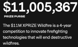
Pacific Gas & Electric (PG&E) said the prize threshold includes detecting and suppressing a high-risk wildfire in 10 minutes or less, and pinpointing from space all fire ignitions across multiple states or countries — in 60 seconds. These are the challenges for innovators in XPRIZE Wildfire, a four-year, $11 million competition to develop and demonstrate fully autonomous capabilities to find and fight wildfires.

XPRIZE Wildfire

The United Nations, the White House, and Congress recently have prioritized destructive wildfires as a major economic, environmental, and safety threat. Patti Poppe, CEO of PG&E, said they are co-sponsoring the project. “Today’s launch of XPRIZE Wildfire is a call-to-action to entrepreneurs, roboticists, artificial-intelligence experts, scientists, and innovators from across the globe to revolutionize wildfire detection and suppression,” she said.

XPRIZE Wildfire encourages teams from around the world to innovate across firefighting technologies in two different tracks designed to transform how fires are detected and suppressed.

    • In the Autonomous Wildfire Response track, teams will need to monitor at least 1,000 square kilometers (386 square miles), and autonomously suppress a wildfire within 10 minutes of detection.
    • In the Space-Based Wildfire Detection & Intelligence track, teams will have one minute to accurately detect all fires across a landscape larger than entire states or countries, and 10 minutes to precisely characterize and report data (with the fewest false positives) to two ground stations.

The day before something is a breakthrough, it's a crazy idea.

The Los Angeles Times reported that Palmer Luckey, a 30-year-old founder of Oculus, a virtual reality company that sold for $2 billion, announced that he was forming the first team to compete for the prize. He said he cares more about solving the problem than winning the money, but he believes the cash will motivate other contestants to form teams and compete.

“I sold my last company for billions of dollars so I can do whatever I want,” he said. “We started working on wildfire tech because I think it’s very, very important. The money in this prize to me is honestly immaterial.” Luckey said at the contest launch that he thinks software, not hardware, will make the difference in detecting and containing fires.

The four-year contest is not winner-take-all. Teams will compete for top prizes of as much as $3.5 million and a bonus $1 million prize to develop technology that can detect fires both from the ground and from space, and fight them using drones or other autonomous vehicles. They’ll compete, for example, to see which technology can accurately detect fires across a land mass the size of a state or country in one minute or suppress fires using an autonomous vehicle within 10 minutes.

Andrea Santy, who is running the competition for XPrize, also said the prize money may not be the most important driver. Teams will benefit from multiple rounds of live testing and validation that would be hard to organize independently. The group is spending an additional $11 million beyond the prize money to run the contest, she said; some of that money will fund a documentary about the competition.

XPRIZE Wildfire is offered in partnership with Co-Sponsors PG&E and Gordon and Betty Moore Foundation, Presenting Sponsor Minderoo Foundation, Bonus Prize Sponsor Lockheed Martin, Supporting Sponsor Conrad N. Hilton Foundation, and Benefactors Nichola Eliovits and Michael Antonov. Sixteen teams are already registered. For more information, to get involved, or to register a team to compete, visit the xprize.org/wildfire website.

Drones being added to Grand Canyon-area wildfire toolbox


Warning: Trying to access array offset on value of type bool in /home/customer/www/wildfiretoday.com/public_html/wp-content/themes/jupiterx/lib/api/image/functions.php on line 61

Deprecated: ltrim(): Passing null to parameter #1 ($string) of type string is deprecated in /home/customer/www/wildfiretoday.com/public_html/wp-content/themes/jupiterx/lib/api/utilities/functions.php on line 206

Deprecated: preg_replace(): Passing null to parameter #3 ($subject) of type array|string is deprecated in /home/customer/www/wildfiretoday.com/public_html/wp-content/themes/jupiterx/lib/api/image/class-image-editor.php on line 177

Warning: Undefined array key "extension" in /home/customer/www/wildfiretoday.com/public_html/wp-content/themes/jupiterx/lib/api/image/class-image-editor.php on line 179

Deprecated: preg_match(): Passing null to parameter #2 ($subject) of type string is deprecated in /home/customer/www/wildfiretoday.com/public_html/wp-includes/functions.php on line 3089

Deprecated: is_file(): Passing null to parameter #1 ($filename) of type string is deprecated in /home/customer/www/wildfiretoday.com/public_html/wp-includes/class-wp-image-editor-gd.php on line 95

Deprecated: preg_match(): Passing null to parameter #2 ($subject) of type string is deprecated in /home/customer/www/wildfiretoday.com/public_html/wp-includes/class-wp-image-editor-gd.php on line 95

Warning: Trying to access array offset on value of type bool in /home/customer/www/wildfiretoday.com/public_html/wp-content/themes/jupiterx/lib/api/image/functions.php on line 61

Deprecated: ltrim(): Passing null to parameter #1 ($string) of type string is deprecated in /home/customer/www/wildfiretoday.com/public_html/wp-content/themes/jupiterx/lib/api/utilities/functions.php on line 206

Deprecated: preg_replace(): Passing null to parameter #3 ($subject) of type array|string is deprecated in /home/customer/www/wildfiretoday.com/public_html/wp-content/themes/jupiterx/lib/api/image/class-image-editor.php on line 177

Warning: Undefined array key "extension" in /home/customer/www/wildfiretoday.com/public_html/wp-content/themes/jupiterx/lib/api/image/class-image-editor.php on line 179

Deprecated: preg_match(): Passing null to parameter #2 ($subject) of type string is deprecated in /home/customer/www/wildfiretoday.com/public_html/wp-includes/functions.php on line 3089

Deprecated: is_file(): Passing null to parameter #1 ($filename) of type string is deprecated in /home/customer/www/wildfiretoday.com/public_html/wp-includes/class-wp-image-editor-gd.php on line 95

Deprecated: preg_match(): Passing null to parameter #2 ($subject) of type string is deprecated in /home/customer/www/wildfiretoday.com/public_html/wp-includes/class-wp-image-editor-gd.php on line 95

Deprecated: ltrim(): Passing null to parameter #1 ($string) of type string is deprecated in /home/customer/www/wildfiretoday.com/public_html/wp-includes/formatting.php on line 4558

Above: An example of one type of drone that can be used to assist in wildfire operations. 

Wildland firefighters at Grand Canyon National Park have added drones to their toolkits, marking the latest iteration of unmanned aircraft systems’ love-hate relationship when it comes to wildfire. 

Rangers have started using drones to scout fires from above, the Grand Canyon News reported. From the article published Tuesday:

Justin Jager, interagency aviation officer for Grand Canyon National Park, Kaibab and Coconino National Forests and Flagstaff and Verde Valley Area National Monuments, said the drones are utilized in conjunction with traditional methods. Operators use the devices to scout fire lines, or communicate information to other personnel in the area.

The unmanned systems aren’t replacing fixed-wing scouting planes. Rather, they’re being used to search a fire’s outer edges and providing intelligence that can help establish stronger fire lines.

Also from the Grand Canyon News: 

“We’re taking what we’re learning and creating a guide for other agencies, like BLM (Bureau of Land Management) or other national parks to create their own programs,” Jager said. “I think they can all benefit from adding this tool.”

Drones and the Grand Canyon have been in the news for other reasons of late, most recently in assisting search and rescue operations for LouAnn Merrell and her step-grandson Jackson Standefer. Both went missing in April while on a hike — the boy’s body has since been recovered, though the woman has not yet been located.

Grand Canyon National Park is the only park with its own fleet of unmanned aircraft that can be used for locating people who have gotten lost, stranded, injured or killed. Under a program that began last fall, it has five drones and four certified operators, the Associated Press reported. 

The drones are about 18 inches across and 10 inches high, with a battery life of about 20 minutes. Drone operators watch the video in real time and then analyze it again at the end of the day.

As fire season revs up, so will conversations about the crossroads of the devices and wildfire. While crews have successfully used drones for recon and to aid in igniting prescribed burns, it’s only a matter of time until a curious hobbyist — once again — flies too close to firefighting operations.

The U.S. Department of Transportation’s Federal Aviation Administration (FAA) has come out in the past supporting the U.S. Department of the Interior and U.S. Forest Service in their simple message to drone operators: If you fly; we can’t.

“Flying a drone near aerial firefighting aircraft doesn’t just pose a hazard to the pilots,” said U.S. Transportation Secretary Anthony Foxx. “When aircraft are grounded because an unmanned aircraft is in the vicinity, lives are put at greater risk.”

That didn’t matter. After a string of incidents last year, the FAA warned in a mass email to recreational drone operators that those “who interfere with wildfire suppression efforts are subject to civil penalties of up to $27,500 and possible criminal prosecution.”

Looking for more about the intersection of drones and wildfire? This dated, yet relevant, Smithsonian video below documents the use of the General Atomics MQ-1 Predator Drone in the August, 2013, Rim Fire in California.