Report released for Mill Flat fire

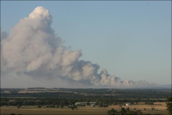
Mill Flat fire, August 29, 2009
Mill Flat fire, August 29, 2009 (from the report)

When the Mill Flat “fire use” fire, which had been managed for almost a month, escaped, ran out of the Dixie National Forest, and burned six homes in New Harmony, Utah on August 29, 2009, the U.S. Forest Service District Ranger, Bevan Killpack said:

We just felt helpless and sick.

The Forest Service has released the review of the incident. It listed these among the lessons learned.

================================

Safety:

The identification and management of risk to firefighters was consistently the highest priority, and this diligence to minimizing human risk exposure contributed to the most important outcome; there were no fatalities or serious injuries as a result of the management of the Mill Flat Fire.

Fire Behavior:

Fire behavior projections have a shelf life. Early modeling provided predictions that informed management decisions in late July and early August, but as live fuel moisture conditions changed the earlier projections were no longer accurate or reliable.

Policy:

Late breaking changes in policy interpretation, new terminology and new decision support software should be seen as a red flag. While these changes just prior to the onset of western fire season were not determined to be responsible for negative outcomes at Mill Flat, it added to the overall confusion and uncertainty and was often a barrier to communication internally and externally. The Wildland Fire Decision Support System (WFDSS) was new in 2009, and there were issues related to clarifying objectives and strategies within WFDSS as it differs from the old system in several important ways. A protocol to guide risk-assessment and decisions on long duration fires would benefit fire managers nationwide.

Situational Awareness:

Managers on the Dixie National Forest have a great deal of experience in successfully managing unplanned ignitions, and one of the results of that history is an expectation of success. Fire managers expected a positive result, fostering a “can do” attitude among the staff in which people who felt concerns about the fire did not feel they could speak up. This view became a lens through which information was filtered, to some extent de-emphasizing concerns raised by the public, obscuring indicators that may have pointed toward changing conditions, and emphasizing the importance of data that supported their vision of a successful outcome.

Australian prescribed fire exceeds expectations

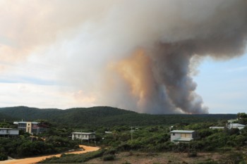
Airey's Inlet fire
Photo: Geelong Advertiser

A prescribed fire in Victoria, Australia on Monday got a little larger than expected in Angahook Lorne State Park about 20 miles southeast of Geelong (map). Originally planned to be 1,074ha (2,654 acres), it jumped control lines within a few hours of ignition Monday evening and burned an additional 50ha (124 acres) before it was contained. “Erratic fire behaviour” was blamed for the bonus acres.

Photo: Geelong Advertiser

Firefighters worked through Monday night to corral the fire with the help of aircraft and 92 pieces of fire apparatus.

Report released for escaped prescribed fire on Kaibab NF

The U. S. Forest Service has released an “Escaped Fire Review” for the Twin prescribed fire which escaped control on the Kaibab National Forest in Arizona on October 2, 2009. Wildfire Today reported on the incident. One of our articles received 15 comments.

Here is an excerpt from the review:

The Review Team found four causal factors contributing to the escape and conversion to wildfire. These four are:

  • Wind Direction Shift – An unforecasted wind direction change resulted in a decision to change ignition operations to prevent established fire from reaching the east control line without a black buffer to protect it. Spot fires that ultimately led to the escape occurred on the east side of the burn unit and presented greater difficulty for holding due to complex terrain and changing fuel types outside the unit.
  • Exceeding Relative Humidity Parameter in Prescription in Combination with Changing Wind Direction – Prescribed burning continued when actual relative humidity levels dropped below prescribed ranges, contributing to spot fire propagation and growth. It is not known if this situation alone would have caused escape of the prescribed fire – it did not in the other burn unit.
  • Fuel Type Differences Outside the Burn Unit – Fuel loading northeast of the burn unit changes significantly to a heavier fuel type increasing resistance to control.
  • Contingency Resource Identification in the Burn Plan – Contingency resources for this burn plan were calculated for fuel models and terrain inside the burn unit which differed significantly from terrain and fuels outside the burn unit. The resource capabilities were not adequate for the differing fuels and terrain.
  • Ensure compliance with policy and direction regarding prescribed burn planning and implementation.

Recommendations from the Review Team include:

  • Ensure compliance with policy and direction regarding prescribed burn planning and implementation.
  • Improve specificity and clarity of burn plans.
  • Complete detailed reconnaissance of burn units and surrounding area.
  • Verify weather forecasts and compare with prescription parameters.
  • Ensure position qualifications, task book requirements, and documentations are complete and meet requirements.
  • Increase integration and communication between resource areas to prevent conflicting management objectives.
Thanks Dick

NPS releases report on Yosemite’s escaped prescribed fire

The National Park Service today released the report on last August’s Big Meadow escaped prescribed fire in Yosemite National Park. The report was completed on November 9, but it was not made available to the public until today.

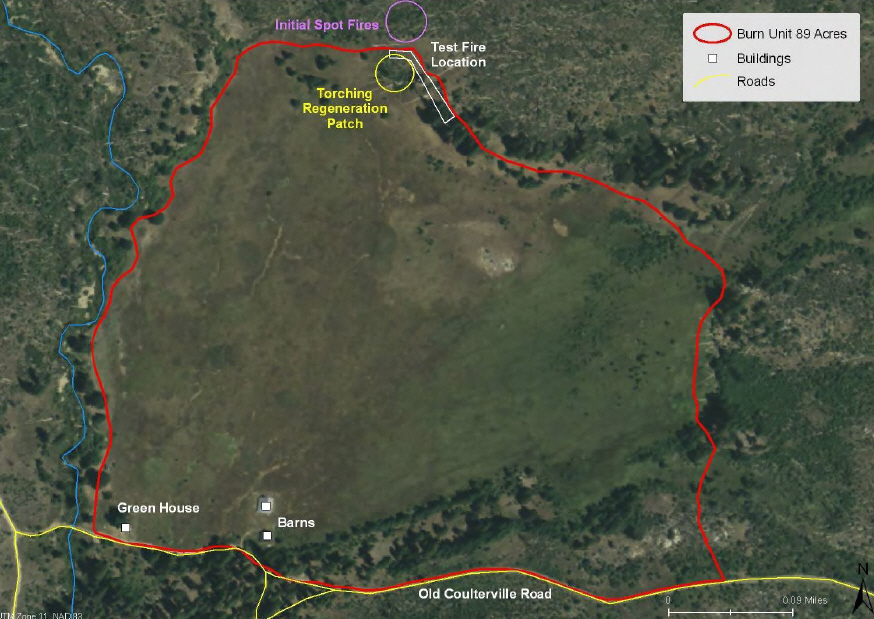
The project was intended to be an 89-acre prescribed fire in a meadow in Yosemite Valley, but it was declared a wildfire 55 minutes after completing the test burn. The fire blackened 7,425 acres before being controlled by 1,300 firefighters at a cost over $15 million. It became the eighth largest fire in California in 2009.

Big Meadow Prescribed Fire Map. NPS

Here are some key points from the report. (Passages in “quotes” are taken directly out of the report, word for word. Everything thing else is paraphrased or summarized.)

    • The test fire began at 10:15 on August 26, 2009. There is conflicting information in the report about the spot fire(s) that occurred at 11:00. There was either a small spot fire outside the perimeter, or there was “group torching of a thicket of small diameter Ponderosa pines” resulting in several spot fires that were suppressed.
    • The ignition of the main burn began at 11:15. Five minutes later at 11:20 a spot fire was found 10 feet outside the line in some pine regeneration. At 11:40 two burning snags were discovered outside the line. At 11:55 there were multiple spot fires burning and a helicopter was ordered for water bucket support.
    • The project was designated a wildfire at 12:10 and “aggressive suppression action began”.

Continue reading “NPS releases report on Yosemite’s escaped prescribed fire”

Looking back at two escaped prescribed fires on Okanogan-Wenatchee NF

The Wenatchee World has an article that reviews two prescribed fires that escaped control on the Okanogan-Wenatchee National Forest in Washington earlier this month, the Beehive and the Preston-Fox fires. Here is an excerpt.

===================

WENATCHEE In early October, when it seemed wildfire season had come to a close, two fires on the Okanogan-Wenatchee National Forest burned out of control.

Intentionally ignited by the U.S. Forest Service as prescribed fires, parts of the Beehive Reservoir Fire southwest of Wenatchee, and the Preston-Fox Fire west of Entiat became uncontrolled wildfires. The agency called in helicopters, hotshot crews and other resources to get the fires under control.

The Forest Service is conducting more and larger controlled burns throughout the Pacific Northwest. In 2002 it burned a total of 34,300 acres in Washington and Oregon, and that figure had more than doubled to about 82,500 acres this year, said regional Forest Service spokesman Tom Knappenberger.

And with more acres to burn, and only short windows in the spring and fall to burn them, fire officials say it’s not a surprise that some of the fires get away.

“You can’t have large prescribed fires without expecting to lose a fire here and there,” said Bobbie Scopa, fire management officer for the Okanogan-Wenatchee National Forest.

She said the Forest Service is trying to burn more acres without spending more money and the only way to do that is to burn larger units.

“If you think about the forest being 3.8 million acres, and say we were burning 10,000 to 15,000 acres a year, we’re not going to make a big enough impact on the forest by doing that,” she said. “We’re trying to increase the size of our projects so we can make a difference.”

Forest spokeswoman Robin DeMario said it’s tough to determine exactly how much money the Forest Service spent to suppress these fires beyond what the agency was already spending to under-burn the areas.

Only about 45 acres of the 600 acres burned in Beehive, and about 100 acres of 1,400 acres burned in the Preston-Fox were not slated for prescribed fire, she said.

The cost of fighting those fires ranged from $600 to $800 per acre, compared with about $30 it costs to conduct a controlled burn, DeMario said.

“We try to be good stewards of the land. And we try to be cost-conscious with American tax dollars, which is why we try to do prescribed burning. It costs a lot less,” she said.

No homes were threatened by either blaze, but the Beehive fire did burn about 40 acres of Longview Timber Corp. property.

Company representative Steve Tift said much of the fire stayed on the ground, but climbed into some trees which now have orange needles. He said he won’t know until next spring if the trees will survive. “We hate to lose any timber,” he said. But added, “Fire in Eastern Washington is just part of life.”
The Preston-Fox Fire burned about 85 acres of the Entiat Experimental Forest, where Forest Service researchers are conducting ongoing studies. That 1,290-acre fire started as a 10-acre test plot that escaped.

Winds pushed both fires out of control.

Scopa said the Forest Service does all it can to get an accurate weather forecast, but the weather doesn’t always do what’s expected.

“We take weather readings on the site for a few days prior to when we’re burning,” she said. The readings include things like fuel moisture and humidity along with winds speed, wind direction, temperature and other factors. The information is sent to the National Weather Service in Spokane, which comes up with a forecast for the specific site before the controlled burn is ignited, Scopa said.

“Is it foolproof, every time you ignite a burn? No, it isn’t,” she said. “This is not an exact science.”
Scopa said it’s never a good thing to lose control of a prescribed burn, but in both fires, the blaze that escaped acted more like a controlled burn than a wildfire — burning out the understory without burning up into the crowns of trees, thereby leaving the larger, older trees in a healthier ecosystem.

“We’re not happy we weren’t able to keep it inside the line, but the area that burned outside the line was just as beneficial, from a resource-benefit standpoint,” she said.

==========================

More information about the Preston-Fox fire can be found HERE.

The Baker River Hotshots Tweeted about both fires in early October.

Escaped prescribed fire burns toward Williams, Arizona

Ten air tankers have been ordered from California to help slow down a fire that began as a 900 acre prescribed fire near Williams, Arizona.

Here is the news release issued by the U. S. Forest Service:

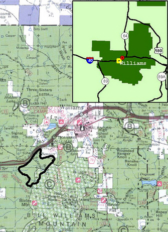
WILLIAMS, Ariz. – Kaibab National Forest fire managers today transitioned the Twin Prescribed Burn to a wildfire. Suppression actions are being taken to stop fire spread on the northeast side of the fire. The Twin Fire is approximately 950 acres, three miles southwest of Williams and west of Bill Williams Mountain.

The prescribed burn was initiated yesterday. During the burn, winds shifted from the northeast to the southwest. Several spot fires occurred outside the project area on the northeast side of the burn as a result. Today, additional resources, including air tankers were ordered to suppress the fire.

The extended forecast calls for moderate winds through the weekend with a chance of precipitation.

Map of Twin fire, October 2. USFS

The Twin fire is southwest of Williams and Friday afternoon was being pushed by a southwest wind. About 350 acres have burned since it was declared an escape. A Type 1 incident management team has been ordered.

The weather forecast (issued Friday night) for Saturday calls for the temperature to be in the high 60s, relative humidity of 19%, and southwest winds at 15-18 with gusts of 30-36. There is a 32% chance of a small amount of rain after 1 a.m. Sunday. By 5 p.m. on Sunday the chance of precipitation should decrease to 3% with an RH of 28% and southwest winds at 32 mph with gusts up to 44.