Yosemite’s acting Park Superintendent takes responsibility for escaped prescribed fire

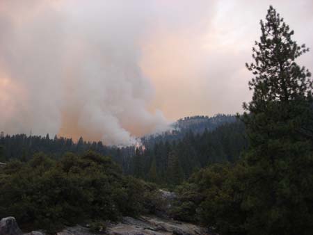
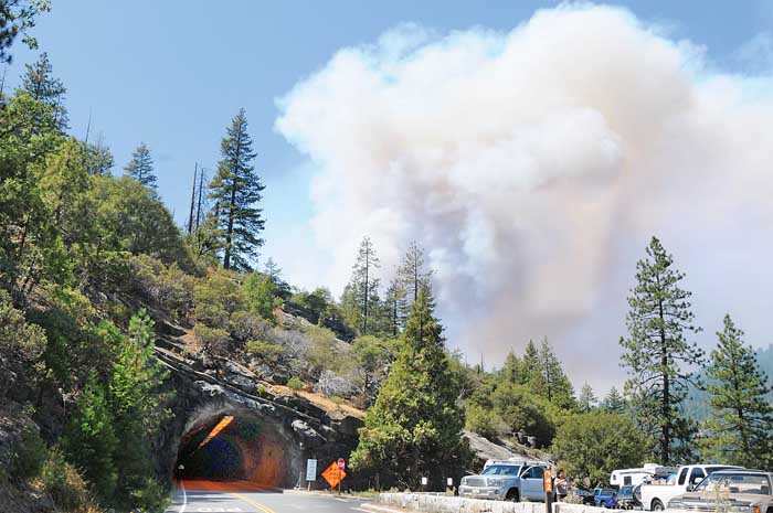
In a refreshing example of accountability, Dave Uberuaga, the acting Superintendent of Yosemite National Park said “I take full responsibility” for the planned 90-acre prescribed fire that escaped and became the 7,425-acre Big Meadow fire.

Mr. Uberuaga’s statement is in stark contrast to Mount Rushmore’s Superintendent Gerard Baker, who according to the Rapid City Journal said after demonstrators breached the monument’s security system on July 8 and hung a huge banner on the sculpture:

“Is it too bad it happened? Yes. Do I think it was my responsibility? Absolutely not. We did everything proper.”

The day following the incident Mr. Baker said:

All security measures functioned exactly as designed.

That statement turned out to be false, and was contradicted later by the National Park Service’s acting Regional Director.

But getting back to the Yosemite fire, an investigation team is on site gathering information about what went wrong two weeks ago when the prescribed fire escaped and required road closures and the evacuation of the community of Foresta. So far the fire has cost $15 million and has been fought by 1,300 personnel.

Acting Superintendent Uberuaga said:

I take full responsibility…I have apologized to the communities. I regret that we had to evacuate them. And I regret the situation we find ourselves in. Still, prescribed fire is a necessary tool in the park.

The park staff has conducted 59 prescribed fires since 2000 for a total of 10,000 acres, including one in July near the community of El Portal.

Some people take a fatalistic attitude toward prescribed fire, saying, “Oh well, prescribed fires do escape sometimes”. Occasionally there may be some events that are totally unpredictable that could cause a fire to escape, but those are very rare. I am of the firm belief that if you have the following, you can be successful with your prescribed fire program.

  1. A good ignition plan
  2. Skilled personnel to execute the ignition plan
  3. Adequate fireline preparation
  4. Skilled holding personnel, properly deployed, and in sufficient numbers
  5. Adequate logistics, i.e., equipment, water, hose lays, drip torch fuel placement
  6. Skilled suppression forces held in reserve for quick deployment
  7. An accurate and current spot weather forecast
  8. A skilled burn boss with at least 12-15 years of wildland fire experience

Note that the word “skilled” is used in four of the eight points.

Again, it is refreshing that the acting Park Superintendent is taking responsibility for the escape. That is the appropriate response instead of saying “We did everything proper”, or everything “functioned exactly as designed”. Which would have been crap, of course.

I have no knowledge of what caused the Yosemite fire to escape, and will make no judgment until the report comes out, but typically an investigation team would point to a failure in one or more of the eight points listed above.

And, congratulations to acting Superintendent Dave Uberuaga for stepping up and being accountable.

UPDATE: The investigation report on the fire was released January 10, 2010.

Yosemite's Big Meadow fire still spreading to the north

The Big Meadow fire, which was planned to be a 90-acre prescribed fire, has fire lines around about 80% of the perimeter but continues to spread on the north side where it has crossed Big Oak Flat Road and is within one to two miles of Tioga Road. Officially, as of 1:00 p.m. PT, August 30 it has burned 4,382 acres and is 50% contained.

This map of the Big Meadow fire was updated at 6 a.m. this morning.

It is interesting to see the completed dozer line, designated by the xxxxxx. It is unusual to use dozers in National Parks, but I am sure the National Park Service feels a great deal of pressure to put out this escaped prescribed fire and minimize the acres burned outside the park boundary.

Big Meadow fire, August 27. NPS photo

A 10 a.m. news release from the park had this information:

Yesterday, firefighters made good progress improving fire lines east of El Portal. The active portion of the fire is in the north and northwest flanks away from Foresta and El Portal. Today, the highest priority continues to be improving fire lines east of El Portal and structure protection in Foresta. Firefighters are aided by 11 water dropping helicopters and six air tankers. Control difficulties continue to be hot weather, low humidity, and steep terrain.

Update on Yosemite’s Big Meadow fire

Yosemite National Park’s escaped prescribed fire, the Big Meadow fire,

…got out of control when one cedar tree took off and cast embers into a lot of dry fuel,” spokesman Gary Wuchner said. “Then the winds changed direction, to the west, and the fire crossed Big Oak Flat and Foresta roads.”

The Big Meadow fire as seen from the Wawona road tunnel, Thursday afternoon. Photo: Maggie Beck

The park says the fire has now burned 2,244 acres, up from the 2,200 reported yesterday.

From the Union Democrat:

On Thursday, turnouts along Wawona Road were jammed with tourists observing the fire’s rapid spread across the stumpy forest and the vibrant cloud of smoke hovering over it.

“It’s exciting but sad,” said Laurie Larson, of San Pedro. “You don’t want to see a controlled burn get out of control.”

Sharon Griffiths, visiting from Reading, Pa., was atop Half Dome watching the prescribed burn begin to get out of control on Wednesday.

“You could see the smoke beginning to really come off the fire,” she said.

Resources from across the state have shifted to the blaze as quickly as it has grown. As of Thursday, 500 firefighters, three helicopters, four air tankers and 24 fire engines were fighting the flames.

Included in the personnel is an interagency team headed by Stanislaus National Forest Division Chief Alan Johnson. Forest Service Hotshot crews from all over the state are fighting the blaze.

On Thursday, air tankers were disappearing into the cloud of smoke to make fire-retardant drops on the fire. Simultaneously, helicopters, sucking water from the Merced River near El Portal, made water drops on the perimeter of the fire. Dozers cut fire lines along the fire’s southern edge.

The smoke seemed to be blowing away from Yosemite Valley, which was relatively clear considering the growing blaze bordering it. Late in the day, along El Portal Road just outside of the valley, the landscape had a golden hue from the blanketing smoke.

Wuchner said, unfortunately, hindsight is not a tool the fire crews can use to douse the flames.

“We are trying to take advantage of not having very many fires in the state,” he said of the large force congregating to extinguish the fire.

Mymotherload.com put together some time-lapse images of the fire:

(THE VIDEO IS NO LONGER AVAILABLE)

Escaped prescribed fire in Yosemite NP

It was planned to be a one-day, 90-acre prescribed fire in Yosemite National Park in the Big Meadow area near the community of Foresta on Wednesday, but the Big Meadow prescribed fire “jumped a holding line” and as of 6 p.m. on Wednesday it had burned 300 acres.

Big Meadow fire at 0915 Aug. 27, view from Turtleback Dome. The small smoke in the distance is the West fire on the Sierra National Forest. NPS photo

A Type 2 Incident Management Team will be assuming command. Numerous air tankers and helicopters are assigned.

Some excellent photos of the fire are on the Yosemite Blog. A web camera showing the fire that updates about every 15 minutes is HERE.

We will update this information as it becomes available.

==========================

UPDATE at 10:00 a.m. PT, August 27

The Park just posted on their web site an update written at 1 a.m.:

This fire is now an escaped prescribed fire and is being suppressed. Fire Managers estimate that 400 acres have burned.

Fire managers began the burn on the morning of August 26 and in a very short time realized the holding lines were not going to contain the fire within the boundaries of this burn. The fire began spotting across the line into pockets of brush, down and dead logs and standing dead trees (snags) to the east of the community of Foresta.

This fire is within the 1990 A-Rock fire scar. Yosemite Helicopter 551 began bucket drops, which was followed by additional aircraft resources including other water dropping helicopters, (one 3000 gal per drop, heavy helicopter), and Cal Fire fixed winged air tankers. However, aircraft resources terminate operations at night; they will resume flying in the morning. Other ground resources were ordered including additional hand crews, engines and water tenders from Mariposa County and the Stanislaus National Forest.

Crews will be working through the night. A Type 2 Incident Management Team will take over the fire on August 27.

Road Closures: The Big Oak Flat Road is closed from Highway 140 to Crane Flat and the Foresta road into the community of Foresta. There is no estimated time for the road to re-open. Highway 120 from Big Oak Flat entrance station is open to Crane Flat, on to Tuolumne Meadows, and Highway 395.

=========================

UPDATE at 10:30 a.m. PT August 27

We just talked with a fire information officer at Yosemite National Park. The fire has now burned 1,170 acres. There was some confusion about the fire name from some sources, but it is confirmed that it is named “Big Meadow”.

Crane Flat Campground and Foresta have been evacuated.

=========================

UPDATE at 6:45 p.m. PT August 27

As of 4 p.m. PT the fire has burned 2,200 acres and it is 10% contained. A Type 2 Incident Management Team will assume command of the fire today. Resources currently on the fire include approximately 500 firefighters, three helicopters, four air tankers, and 24 engines.

=====================

UPDATE at 10:27 p.m. PT August 27

McGowan’s Type 1 Incident Management Team has been mobilized for this fire.

Investigators report on the Florida I-4 fog/smoke incident

fog-smokeInvestigators have released a report on the Florida January 8 incident that we reported on in which smoke from an escaped prescribed fire may have mixed with fog causing poor visibility on Interstate 4 resulting in five fatalities in vehicle crashes. The report issued by the Florida Department of Agriculture and Consumer Services says:

“…an unpredictable change in weather caused the prescribed burn to burn erratically which resulted in spot fires.”

Tampa Bay Online has more details:

“TALLAHASSEE – A state investigation has cleared wildlife officials who last month lost control of a prescribed burn that may have contributed to a 70-vehicle pileup on Interstate 4 in Polk County.

The investigation by the Florida Department of Agriculture and Consumer Services concluded changing weather conditions Jan. 8 caused the 10-acre planned burn to jump firelines and spread to 400 acres. The National Weather Service said smoke from the fire could have combined with fog the next morning to cut visibility on the highway to nearly zero.

Five people died in the predawn pileup and resulting fires, prompting questions about how the fire got out of control and whether the state should have held a controlled burn in the dry season less than a mile from the interstate.

The Florida Highway Patrol is conducting a homicide investigation that also will look at whether smoke from the wildfire played a part in the wrecks.

The report by the Agriculture Department’s law enforcement division states those in charge of the fire followed correct procedures but that an “unpredictable change in weather caused the prescribed burn to burn erratically which resulted in spot fires.”

“There does not appear to be any evidence of criminal violations or gross negligence” by those involved in the burn, investigators concluded in their report.

Fish and Wildlife Conservation Commission employees conducting the burn reported that the humidity had dropped sharply about an hour after the fire was set at 10 a.m. and winds picked up, spreading the fire outside the protective earthen barriers.

The National Weather Service confirms there was a drop in humidity at the fire site, but meteorologists said that could have been caused by the fire. As warm air from a fire rises, it forces drier air downward. Drier air aids the spread of fire, especially when rainfall has been sparse for a long period.

Daniel Noah, warning coordination meteorologist with the National Weather Service, said the agency has no way of knowing whether wind speeds around the fire picked up or wind directions changed. However, Noah did not rule out that possibility.”

A preliminary report issued by the Florida Highway Patrol does not even mention the prescribed fire.

News roundup, January 16, 2008

Cleveland National Forest Completes Hydromulch on Santiago Fire

The U.S. Forest Service completed their $5 million project to treat 1,241 acres with hydromulch in areas burned by the October fire in Orange County in southern California. The hydromulch is a wet mixture of 40% shredded wood and 60% paper with a gum-based tackifier, a sticky substance that helps the mulch material cling to terrain. Single engine air tankers and helicopters applied the green-dyed biodegradable material to help minimize erosion.

5th Fatality in Florida I-4 Smoke/Fog 50+ Vehicle Pileup

A 5th person has passed away as a result of the 50+ vehicle pileup that may have been caused by smoke from an escaped prescribed fire combining with fog on January 9. Smoke from the fire continues to cause lane closures on the Interstate. The Florida Division of Forestry is still mopping up the 380 acre fire which resulted from a prescribed fire conducted by the Florida Fish and Wildlife Conservation Commission. (see the posts on Jan. 9-10 for more information, here, here, and here)

Witch Creek Fire Was 2nd Costliest Disaster of 2007

The October Witch Creek fire which started near Santa Ysabel in San Diego County California was the second costliest incident in 2007 for insurance companies, causing $1.1 billion in damage. Started by downed power lines during a Santa Ana wind event, the fire burned 197,000 acres and destroyed 1,650 structures. The number one natural disaster for insurance companies was the four-day storm in mid-April that caused $1.3 billion in damages in 19 states.