
A new fire that ignited over the weekend in southwest Oregon is threatening the community of Agness, Oregon, on the Rogue River west of Grants Pass. The fire quickly grew to more than 8,000 acres despite USFS initial attack efforts.
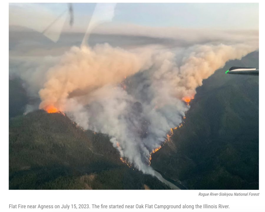
Oregon Public Broadcasting (OPB) reported that the Flat Fire is growing fast on the Rogue River–Siskiyou National Forest, between Gold Beach on Oregon’s south coast and Grants Pass on I-5. Weather conditions over the last couple days contributed to the quick spread, and an IMT took over from local agencies yesterday. The fire is burning just a couple miles from Agness, near the confluence of the Rogue River and the Illinois River.
The Rogue River flows 215 miles from Crater Lake to the Pacific Ocean. The 84-mile Congressionally-designated “National Wild and Scenic” portion of the Rogue begins 7 miles west of Grants Pass and ends 11 miles before its mouth at Gold Beach.

Jefferson Public Radio reported the fire grew more than 8,000 acres in under three days. Nearly 400 firefighters were working the fire, which threatens about 40 structures in and around the small community of Agness. On Monday, crews were building fireline to prevent further spread.
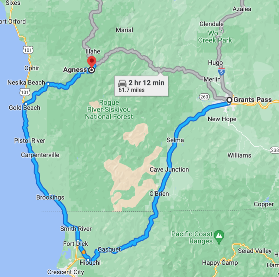
There’s a reason (or 4) that GoogleMaps will show you this “preferred route” and the “short route” between Grants Pass and Gold Beach; it’s really skatey even in the summertime, and LOTS of people get lost or stranded on Bear Camp Road. Please DO NOT interfere with firefighter vehicle traffic up there because you wanto “go get a look at the helicopters” or something … interfering with firefighting operations, whether you’re flying a drone or driving a pickup, will land you in jail, and some sheriffs are touchier about this than others.
It was planned yesterday that evening operations would include night crews on the northwest corner of the fire, if conditions permit, which would allow crews to burn out vegetation between fire crews and the active fire.
The fire recently was reported at just over 8,200 acres, with a total 378 personnel assigned to the incident. Resources at that time included 16 engines, 13 crews, 2 dozers, 7 helicopters, and 2 water tenders.
Closures: At least one closure order is in place for the safety of the public. Please be careful when driving in the area and do not drive toward the fire if you don’t live there or work there.
Restrictions: Fire restrictions are in place on the Rogue River–Siskiyou National Forest. The Forest has several closures and public use restrictions on the wild section of the Rogue River [HERE] but they’re mostly in pdf format and thus may not be accessible for everyone. Your best bet for mostly current info is inciweb. (Note the correct URL for this website has changed several times over the years, but for right now it is inciweb.nwcg.gov)– and even though the site warns you to redirect to inciweb.wildfire.gov, THAT DOES NOT WORK. The Flat Fire incident page doesn’t yet have any MAPS, but in the meantime here’s one of the general size of it, northeast of Gold Beach:

The Flat Fire is now the largest wildfire burning in Oregon and more crews and other resources are expected in the next few days; current management is under Albrecht’s Northwest Incident Management Team 6.
An evacuation shelter has been established at Gold Beach High School for anyone displaced by the fire and needing assistance. As of Monday, there were no evacuations ordered. Residents can sign up for emergency notifications with the Curry County Emergency Management Department.
There’s a small collection of outstanding photos online from the Coos Forest Protective Association. We expect more in the coming days.
KPIC-TV News reported that fire officials said the Flat Fire is burning in historic burn scars from both the 2002 Biscuit Fire and the 2018 Klondike Fire. Firefighters are working around numeroous standing dead trees and dense vegetation within these burn scars, and the landscape in this part of the Pacific Northwest is characterized by very steep terrain and extremely limited access options. Fire managers are deliberately considering firefighting tactics to keep crews safe, while protecting surrounding communities and infrastructure.
More resources arrived this morning, and their numbers will be boosted over the next several days. Crews are strengthening and building new firelines, and fire managers will assign aviation resources as conditions and visibility allow. Watch for updates from the 
Rogue Valley Interagency Community Center.
As of this morning there were no official closure orders for the area, but people are STRONGLY ADVISED TO STAY OUT. This is a rugged part of Oregon’s coastal mountains where people often get stranded or disoriented or lost, and local fire and law enforcement people don’t have a lot of spare time right now, with a fast-growing fire of this size, to come look for you. Stay out, and avoid getting in the way of firefighting operations. The rugged, mountainous terrain makes it more difficult for firefighting crews to access the area, BUT the Lost Coast Outpost reports that firefighters’ goal is “full suppression” on a rapidly growing fire in extreme summer temperatures.
Nationally, there are now eight fires being managed under a strategy other than full suppression. For updates on the Flat Fire, you can email 2023.flat.or@firenet.gov
No one was evacuated as of yesterday morning, Curry County Commissioner Brad Alcorn told the Lost Coast Outpost. But because of the steep and harsh terrain and hazardous weather conditions, Alcorn said he expects the fire will grow.
“There are a handful of residences up there, probably 14 to 15 homes, and the sheriff has contacted everyone,” Alcorn told the Outpost. “They’re in communication, so if there is a situation where we need to do an immediate evacuation we have a mechanism in place to make sure that happens safely.”
The Flat Fire was first reported at about 6 p.m. Saturday, Alcorn told the community in a video briefing on Sunday. It’s burning near Oak Flat, not far southwest of Agness, according to a Rogue River-Siskiyou National Forest news release on Sunday. The Forest Service said two days ago that about 40 structures were threatened. The fire is making its biggest gains in the Lawson Creek drainage; it’s on both sides of the Illinois River, burning in the 2002 Biscuit Fire scar.
The fire was mapped at 5,477 acres via an infrared flight two days ago, said Doug Epperson, the PIO for Northwest Incident Management Team 6, the Type 2 IMT that took over fire operations at 6 a.m. yesterday. He said the fire is burning in new regrowth that occurred after the 2002 Biscuit Fire.
“There’s been a lot of growth since then,” he added.

A red flag warning was in effect through this morning, and those weather conditions will likely contribute to additional fire spread. An air quality advisory was also issued for parts of Curry and Josephine counties; air quality could be diminished because of smoke from the fire. The National Preparedness Level is still at 2 and the national sit report lists just 16 large fires today.
