Fire information on InciWeb is now subject to being deleted after it is no longer current

We learned recently that agency personnel who post information on the InciWeb website are being told to delete media files, especially videos, when they are no longer current, and to remove all information about an incident when it is no longer active. Wildland firefighting agencies use the website to post current information about ongoing wildfires and other incidents.

There are two reasons for deleting the information according to Jennifer Jones, a Public Affairs Specialist for the Forest Service at the National Interagency Fire Center. The files need to be removed in order to free up storage space. And, in the new version of InciWeb introduced in March, 2018, there can be a clutter of icons on the map representing fires, making it difficult for the public to find the fire they are interested in.

“With the launch of the redesigned InciWeb public site”, Ms. Jones explained, “it has become an issue. Having inactive incidents still showing clutters the map and makes it hard for members of the public to find information about current active fires. In addition, since the capability to add video to InciWeb was added a few years ago, storage space for those files which can be fairly large has also become an issue.”

Ms. Jones said this policy of deleting incidents that are no longer active has always been the policy. But I have found that before the recent major change, I could use Google to search just the InciWeb site to find complete records of fires that occurred years earlier. The new version wiped out, as far as I can tell by using Google, public access to all of the fire information before March, 2018. And now that the delete-media-and-inactive-fires policy is being implemented or enforced, this important data could disappear in a matter of days after being posted.

In the last few years the prices for storage space for digital data have plummeted, so it seems odd that this can be a limiting factor on what information is provided to the public about ongoing emergencies. We should be striving for serving the public with transparency rather than purging important historic information about wildland fire events that affect millions of people.

The problem of the clutter of icons that represent fires on the interactive map on the new version of InciWeb could be mitigated by restoring the user-sortable table that worked very well in the previous version of the website.

We asked Ms. Jones about retention of the data at InciWeb. “Since its inception, the purpose of InciWeb has been to provide a ‘one stop shopping’ source of information about current wildfires” she said. “InciWeb was never set up as an official system of record and was never intended to be used for historic information or reference purposes and it has never been funded or staffed to serve those purposes.”

Before a fire completely demobilizes, the Documentation Unit Leader at the incident command post is supposed to assemble all pertinent data according to very strict guidelines established by the National Wildfire Coordinating Group.  It can be a daunting task. The result can look like the two examples below, which are from a training program for incident personnel.

records archive
Example of archived documents, from Incident Records Training.

When InciWeb is operating properly it can be a very user-friendly environment for viewing information about an incident. Anyone with internet access can go to the site 24 hours a day, seven days a week, and with a few clicks find troves of information within minutes. This can be invaluable for citizens concerned about nearby wildfires, those learning about their environment, as well as reporters, scientists, and authors, both during and after a fire.

records archive
Example of archived documents, from Incident Records Training.

Now that complete records of fires on InciWeb are going to be purged after the fire is no longer active, try to picture how these people will obtain information from the official records shown in the two photos above.

It simply will be far, far more difficult than going to an internet site and finding the data in a minute or two. They could submit a Freedom of Information Act request. We have filed a few of those with the U.S. Forest Service. In one example, even after filing a FOIA, the agency refused to give us a copy of an air tanker study completed under contract by the Rand Corporation. In another case it took the USFS eight months to send us a copy of an existing non-controversial Excel file that we requested.

RECORDS
Scene from “Raiders of the Lost Ark”

Major changes made to InciWeb this year

(Originally published at 3:44 MDT September 11, 2018)

The website where firefighting agencies can post current information about ongoing wildfires and other incidents went through a major change in March. InciWeb, a nickname for Incident Information System, was created in 2004 to provide for the public a single source of incident-related information. When measured by the number of visitors, it has been a huge success. Before it existed it was difficult for the public to ferret out current information about fires that may be threatening their property. Incident management teams would create websites from scratch for fire information, staple paper copies of updates along a “trap line” of bulletin boards in communities near the fire, place the information on social media platforms, or just send news releases to their regular mailing list.

InciWeb
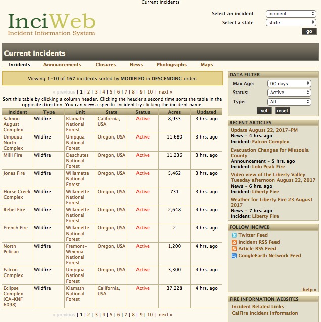
Screengrab of InciWeb, August 23, 2017.

In the last 15 years the old user interface (above) had remained virtually the same, as the contracted developers that managed the back end occasionally made minor changes and fixed bugs when requested by personnel at the National Interagency Fire Center, primarily the U.S. Forest Service. But the new version that appeared in March of this year (below) looked completely different to the site visitor.

Inciweb
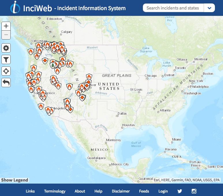
Screengrab of InciWeb, August 23, 2018.

The most profound and noticeable change is there is no longer a table that lists multiple fires, along with the agency, state, acres, and how current the update was. The table in the version that disappeared in March could be sorted with a single click on one of the headers and then you could click to see successive pages each with 10 additional incidents. You could view the largest fires, those most recently updated, all fires in Utah, or see all the fires on the Umpqua National Forest grouped together, for example. The system also had the ability to only display fires in one state, by clicking on “Select a State” at the upper-right.

The new system has a “Search incidents and states” option too. But when you type the name of a state in the box the image simply zooms the map to that state. This is helpful only to someone who can’t find a state on a map.

With the revised system there are two ways to get detailed information about a fire. If you know the name you can look for it in the pull-down list at upper-right.

If you know what region of the country the fire is in you can zoom the map to that area. Then you can manually search fire-by-fire by hovering a mouse pointer over an icon until a fire name appears. Clicking adds a little more information — the acres, when it was updated, and the containment percentage. (Containment was apparently added for those who incorrectly assume it actually is reliable information.) Clicking on “Go to incident” displays all of the basic data about the incident. Other buttons to click on then include Announcements (which from my experience are almost never posted), Closures, News, Photographs, and Maps. I don’t know what the difference is between Announcements and News.

There are some features I like about the new version of InciWeb. The overall appearance is clean and modern looking. The map on the home page is much larger than in the previous iteration, and the thumbnails of photos and incident maps are also a little larger.

The platform also seems to be more stable and probably has more capacity for hosting site visitors. It also loads fairly quickly. At times over the years it would crash on a regular basis, sometimes for days. The first time we wrote about the site was in 2008 after it had been intermittently up and down. Here is an excerpt:

…But when there are many fires burning, or there are one or two that generate a lot of interest, the web site can’t handle the load and chokes, not working at all. When the need for it is the greatest, it is most likely to fail.

And in 2013 we wrote:

If a site with this purpose can’t have at least 99.99 percent uptime, and load a page reliably in less than three to four seconds, it needs to be put out of its misery.

The big negative, as described earlier, is that a table with an overview of groups of 10 fires, sorted by one of six criteria of your choosing, is no longer available. It also was a good method of finding a particular fire, rather than hunting icon by icon in the current version. Removing this feature is a step backward for anyone interested in learning about or monitoring fires in their local unit or state, or wants a list of all of the fires ranked by size. Previously every fire could be seen at a glance by continuing to click on “next” above the table.

A couple of months ago we asked Christine Schuldheisz, a Public Affairs Specialist with the U.S. Forest Service who is the business lead for InciWeb, why the overview table was discarded:

The redesigned website is the result of collaboration between local, state, tribal and federal agencies across the country. Dozens of InciWeb users from these agencies provided input on how to improve the website and participated in extensive testing of it.  Based on feedback and testing we decided to remove the table and replace it with an interactive map for users to view incidents based on their location.  A user can use the map or search bar at the top to search by incident or state.

[Update at 5:03 MDT September 11, 2018: Ms. Schuldheisz just notified us,  after she read this article, that there is a way to view a list of fires. At the bottom of the home page, in the footer, click on Help, and in the “Web Accessibility (Section 508)” paragraph there is a link that will bring up a list for the visually impaired. She said, “We are adding a filter and a some other features to this table to make it easily found in the footer.” We checked out the table and it is sorted by update time, with the most recent on top. There is no apparent way to sort the column of your choice.]

Now, finding a particular fire can be challenging. So much so that the mangers of InciWeb are ordering agency personnel who post fire information to delete non-active fires, as well as “media” and especially videos when they are no longer current. This is to free up needed storage space, Ms.  Jones told us, and to decrease the clutter of icons on the map to make it easier to find an active fire.

We will be posting another article about the implications of purging fire information from the site.

inciWeb poll change new
Poll conducted by Wildfire Today in July about the new version of Inciweb.

A poll we conducted in July found that 47 percent of the respondents preferred the old version of InciWeb vs. 33 percent who liked the new edition better.

What do you think about the changes to InciWeb?

InciWeb is failing

InciWeb fail

(Originally published at 5:31 p.m. MDT, June 20, 2013; updated June 21, 2013)

I have tried to be patient. I have given InciWeb the benefit of the doubt. I WANT to like InciWeb. The user interface looks fine, it strives to contain useful information, and if it worked well, it could provide a very valuable service.

Before U.S. Forest Service employee Jon Holden created it in California 10 years ago, it was difficult for the public to ferret out current information about fires that may be threatening their property. Some Incident Management Teams created web sites for fires, but they were all different, and if another IMTeam took over a fire they would sometimes start over again with a different web site, keeping the affected citizen guessing …  and hunting.

But now in its tenth year, I have to admit, InciWeb is a failure. To be precise, too often it fails to perform in a manner that meets the needs of its customers. After 10 years, it is reasonable to expect that a web service could have worked out the bugs and would be extremely reliable. ESPECIALLY, if the purpose of the web site is to provide critical information to users who in many cases at that moment are being adversely affected by an emergency. For some it may be one of the worst days of their lives. If a site with this purpose can’t have at least 99.99 percent uptime, and load a page reliably in less than three to four seconds, it needs to be put out of its misery.

How embarrassing is it that a web site existing primarily to provide information during emergencies has THIS as a banner across the top of the page:

Inciweb unresponsive

That banner has been on the site for months, not just for a few hours while a bug is being fixed.

In recent weeks the performance of the site has gotten even worse. Sometimes the home page loads in less than a second. Other times it will not load at all and an error message appears instead. Frequently if a page does load correctly, it can take 10 to 20 seconds for it to appear. Several times in recent days when the page loaded the formatting was completely screwed up and was unusable. This problem, I have found, is intermittent. At times the information is available very quickly, but too often, the site is virtually worthless.

And this is June — we are not yet into the busy part of the western wildfire season.
Continue reading “InciWeb is failing”

The status of InciWeb

InciWebIn 2008 InciWeb, the site to which the public is directed to obtain critical information about ongoing wildfires, was inoperable at times. During a couple of the outages we wrote “When the need for it is the greatest, it is most likely to fail”, and, “The site that is supposed to provide information about current wildland fires is least dependable when it is most needed.” At least some of the problems were due to the U.S. Department of Agriculture network and servers that were hosting the site.

In recent years, however, the system has been much more dependable. We have rarely had trouble accessing the site — until the last couple of weeks, when the performance has been erratic. Sometimes the pages load immediately, and maybe a few seconds later it might take half a minute for a page to appear.

On April 20 when the Fawnskin Fire was burning on the San Bernardino National Forest in southern California, the Forest sent this via Twitter:

San Bernardino NF, @SanBernardinoNF

Fawnskin Fire – inciweb website is down – all fire info will be handled via this twitter feed and recorded msg at 909 383 5688

In February some people in the U.S. Forest Service were working on “reengineering” the site, some of which is still going on. When we inquired yesterday about the status of InciWeb after the San Bernardino NF had the problem, Jennifer Jones, a spokesperson in the U.S. Forest Service’ Boise office, was kind enough to reply to us on a Sunday, saying:

It appears that the current problem isn’t with the inciweb application itself but with the new Ness Application Portal through which you now log in to inciweb to enter and update incident information. The portal was instituted recently to enhance the security of fire and aviation management IT applications. The fire and aviation management IT staff is working to correct the issues as we speak.

Some people don’t like InciWeb, but I think it is an excellent concept that should be maintained and improved to the point where it is dependable and user friendly for both the public and those who input information about fires and other incidents. The servers and the network hosting the site need to be robust enough that it will continue to work when it is most needed — that is, when there are several large fires going on at the same time that affect huge numbers of people. If we can’t depend on it to work when it is most needed, then it is a failure. Remember, this site is for providing information about ongoing emergencies. Your average IT person or web designer might have trouble understanding this.

Once upon a time I was talking with Greg Greenhoe, a former Area Commander and Planning Section Chief, about the best method to determine how many copies should be made of an Incident Action Plan at a large incident. His secret was to count the names of everyone who you think needs or wants a copy, then double it and add 10. It’s a good rule of thumb. The same concept should be employed by those designing a network to host InciWeb. Estimate how many people you think will attempt to access the site at the same time during peak periods while numerous large fires are burning, then double that figure and add… what, 10 thousand?

If people don’t know where to find fire information, then posting it somewhere serves little purpose. When agencies choose to place their incident information on Twitter, Facebook, Google Docs, or Flickr rather than InciWeb, it creates a confusing mess. If InciWeb is dependable and user friendly for everyone involved, it stands a better chance of success and will be more likely to serve the needs of the intended users.

One more thing…. the URL, the web address, of InciWeb will be changing. The new address, which works now, is http://inciweb.nwcg.gov/ The old address, http://inciweb.org, is still functional but will be going away eventually. So you might as well update your bookmarks or favorites now.

Wallow fire fight moves into New Mexico

Update at 1:28 p.m. MT, June 12, 2011

From the Wallow fire incident management team:

Apache County Sheriffs Office Lifts Evacuation of Springerville, Eagar and South Fork

On Sunday June 12 at 10 am, the Apache County Sheriffs Office, after consulting with fire officials, has lifted the evacuation for the residents of the Springerville, Eagar and South Fork areas.

It has been determined that fire conditions have diminished enough that they will no longer be a threat to the citizens of the towns.

It should be noted, however, that the smoke still poses serious health hazards as has been outlined by Chris Sexton, Apache County Health Director, and the smoke problems may continue for weeks.

Because of the health problems associated with the smoke from the Wallow Fire, Apache County Public Health Services District and the Emergency Operations Center warns residents of Eagar, Springerville and South Fork that it would be best not to return to their homes until the concentration of smoke diminishes.

Alpine and Nutrioso are still under evacuation orders.

The full news release can be viewed at: http://593info.org/?p=1289

===========================================
Update at 11:33 a.m. MT, June 12, 2011:

The Wallow fire incident management team at 10:51 a.m. released their “8:00 a.m.” update. The size of the fire increased by about 13,000 acres to 443,989 acres, and it is still reported to be 6% contained.

  • Total personnel: 4,311, including 24 hot shot crews and 84 other hand crews
  • Residences destroyed: 29 and 5 damaged (4 commercial structures destroyed)
  • Resources include: 15 Helicopters, 5 Air Tankers available; 334 Engines; 66 Water Tenders; 27 Dozers

Here is an excerpt from their update, which for some crazy reason was sent out as a GoogleDoc, rather than a format that could be more easily utilized:

The fire is 6% contained. Last night firefighters finished burnout between Forest Road (FR) 275 and FR 220 northeast of Alpine; burnout completed near South Fork; and a 3-mile burnout operation was completed in the Turkey Creek drainage along FR 281 toward Blue Creek. Good progress continued along the southwest and west flanks of the fire.

Today:

Burnout operations will continue SE along FR 220 to tie in with State Hwy 180, northwest of Luna, NM. Burnout preparations will continue along FR 74 and Trail 33 through Malay Gap and along FR 116. Structure protection, burnout and mop-up operations to strengthen containment lines and patrol for spot fires will continue.

A Red Flag Warning has been issued for today from 11 am to 8 pm, SW winds 15 to 20 mph, gusts to 40 mph; relative humidity 5-10%.

Public Information:

The public may call the following numbers for area-specific fire information:

  • Springerville, Eagar, Greer, Alpine Information: (928) 333-3412, (702) 308-3238, (702) 308-3357, and (702) 308-8227
  • Luna and Reserve NM Information: (575) 533-6928
  • Areas south and west of the Fire: (928) 205-9884

Information is available at:

InciWeb is still down. The NPS, USFS, USFWS, BLM, and BIA need to make it a priority to fix the infrastructure supporting InciWeb, so that it can be robust enough to work even when fires are burning, which is the only purpose of the site.

================================================

Wallow fire drip torch 6-8-2011
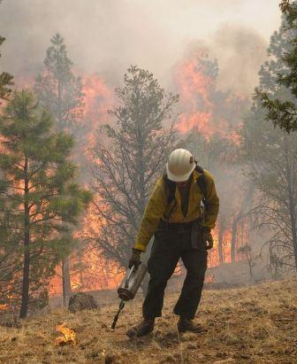
A firefighter on the Diamond Mountain Hotshots uses a drip torch on the Wallow fire, June 8, 2011. Photo by Kari Greer for NIFC. Credit: U.S. Forest Service

On Saturday, firefighters on the Wallow fire, most of which is in eastern Arizona, continued their backfiring operation across the state line in New Mexico. As of Saturday night they had completed over six miles of firing, most of it along Jenkin Creek Road and Forest Road 220, working southeast toward the community of Luna, NM, population 246. As of Saturday night they had progressed to within about two miles of Luna.

The purpose of the backfiring is for the controlled fire they are setting to remove the vegetation, the fuel,  ahead of the main fire which is actively spreading towards the fire they are igniting. If everything goes as planned, the two fires will burn together and that eight-mile section of the fire will be contained.

Unfortunately, InciWeb, which has been having problems for the last couple of days, is down again Sunday morning, and the Wallow fire incident management team has not sent out any updates since Saturday afternoon. At that time the size was 430,171 acres and it was 6% contained. A revised acreage will probably show that the fire has grown by 10,000 to 15,000 acres.

On Saturday, on the west side south of Greer, the fire burned intensely in some areas while it continued to move slowly on the south side. The north and northeast sides of the fire were not very active on Saturday.

There were 15 helicopters and six air tankers assigned or available on the fire yesterday. Tanker 911, the DC-10, made two sorties to the fire.

Below are two maps of the Wallow fire. The second one is a 3-D map that shows the area on the east side where the firefighters are conducting the backfire in New Mexico. The vertical white line is the AZ/NM border.

Continue reading “Wallow fire fight moves into New Mexico”

InciWeb; broken again


InciWeb is only working intermittently again today. The site that is supposed to provide information about current wildland fires is least dependable when it is most needed. The agencies that operate this site should either fix it or shut it down. This has been going on for years. The organizations that are responsible for the web site are:

  • U.S. Forest Service
  • Bureau of Land Management
  • Bureau of Indian Affairs
  • U.S. Fish and Wildlife Service
  • National Park Service
  • National Oceanic and Atmospheric Administration
  • National Association of State Foresters
  • U.S. Fire Administration

Supposedly the website is using “version 2.1 beta”. Maybe it’s time, after several years, to take this seriously and develop a version that is not BETA. And, invest a few dollars to ensure the hardware is adequate. Or shut it down.