Joint Fire Science Program produces map of firefighter burnovers

Map of firefighter burnovers
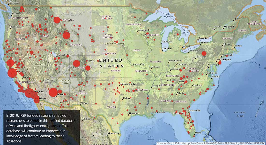
Screenshot of a map of firefighter burnovers. The size of the circle is proportional to the number of personnel involved. JFSP, November, 2020.

The Joint Fire Science Program (JFSP) has produced a story map highlighting some of the organization’s success stories, in particular their research in entrapment avoidance, safety zones, and escape routes.

The screenshot above is from an interesting interactive map in the presentation showing the locations where wildland firefighters were burned over by fires. The size of the circle is proportional to the number of personnel involved in each incident, but not every burnover resulted in fatalities. A click on the circle brings up a few details about the incident.

The JFSP was established by Congress in 1998 and is jointly funded by the Department of the Interior and the U.S. Forest Service. The Joint Fire Science Plan written then, (linked to on their website) says the organization “will address issues critical to the success of the fuels management and fire use program.”

In FY 2017, 16 of the 22  JFSP approved and funded research projects were various ways of studying vegetation. Back then we wrote:

It would be refreshing to see more funds put toward projects that would enhance the science, safety, and effectiveness of firefighting.

Since then the emphasis has shifted a little — in a good way. In FY 2020 their research grants were for projects on one of two topics:

  1. Effectiveness of fuel breaks and fuel break systems.
  2. Reducing damages and losses to valued resources from wildfire.

And in FY 2021: (they expect total funding to be $1.5 to $3.5 million):

  1. Sources and distribution of human-caused ignitions and their relation to wildfire impacts.
  2. Reducing damages and losses to valued resources from wildfire.

Wildfire Today continues to advocate for the the JFSP to place a major emphasis on developing science that can be directly used by wildland fire personnel to enhance their safety, firefighting efficiency, and reduce the undesirable and sometimes catastrophic effects of uncontrolled wildfires on citizens, infrastructure, and property. If the JFSP Plan needs to be revised to accomplish this, then let’s get it done.
Wildland fire research funding opportunities

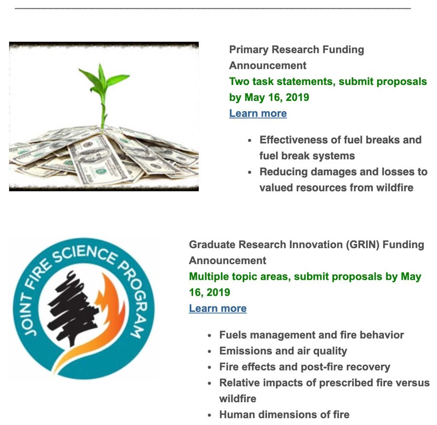
The Great Basin Fire Exchange has accomplished a good deed for the wildland fire research community. They took a painful-to-read announcement about opportunities for research funding from the Joint Fire Science Program and distilled it into a short and uncomplicated notice.

(The links in the image below don’t work, since it’s a screen shot, but they both go to HERE.)

jfsp funding announcement

A researcher considering applying for funding will still need to go to the JFSP site to get the details. Proposals are due by May 16, 2019.

In FY 2017, 16 of the 22 approved projects were various ways of studying vegetation. Back then we wrote:

It would be refreshing to see more funds put toward projects that would enhance the science, safety, and effectiveness of firefighting.

Judging from the descriptions of the current funding opportunities it appears that the JFSP is moving away from awarding 72 percent of the awards to vegetation studies.

Researchers compare smoke emissions from prescribed and wild fires

DC-10 drop North Park Fire
A DC-10 comes out of the smoke dropping retardant on the North Park Fire in Southern California, October 12, 2018. Screen grab from @ABC7Leticia video.

Four researchers, in a study funded by the U.S. Forest Service, evaluated data collected in 25 previous studies to compare exposure to particulate matter (PM2.5) created by prescribed fires and wildfires. The authors were Kathleen Navarro, Don Schweizer, John Balmes, and Ricardo Cisneros. Titled, A Review of Community Smoke Exposure from Wildfire Compared to Prescribed Fire in the United States, it is published under Open Access guidelines.

Below are excerpts from the study — the abstract and conclusions. And, information about a March 21 webinar featuring Ms. Navarro about the health effects of vegetation smoke.


Abstract

Prescribed fire, intentionally ignited low-intensity fires, and managed wildfires — wildfires that are allowed to burn for land management benefit-could be used as a land management tool to create forests that are resilient to wildland fire. This could lead to fewer large catastrophic wildfires in the future. However, we must consider the public health impacts of the smoke that is emitted from wildland and prescribed fire.

The objective of this synthesis is to examine the differences in ambient community-level exposures to particulate matter (PM2.5) from smoke in the United States in relation to two smoke exposure scenarios-wildfire fire and prescribed fire. A systematic search was conducted to identify scientific papers to be included in this review. TheWeb of Science Core Collection and PubMed, for scientific papers, and Google Scholar were used to identify any grey literature or reports to be included in this review. Sixteen studies that examined particulate matter exposure from smoke were identified for this synthesis — nine wildland fire studies and seven prescribed fire studies. PM2.5 concentrations from wildfire smoke were found to be significantly lower than reported PM2.5 concentrations from prescribed fire smoke.

Wildfire studies focused on assessing air quality impacts to communities that were nearby fires and urban centers that were far from wildfires. However, the prescribed fire studies used air monitoring methods that focused on characterizing exposures and emissions directly from, and next to, the burns.

This review highlights a need for a better understanding of wildfire smoke impact over the landscape. It is essential for properly assessing population exposure to smoke from different fire types.

Conclusions

Destructive wildfires have higher rates of biomass consumption and have greater potential to expose more people to smoke than prescribed fires. Naturally ignited fires that are allowed to self-regulate can provide the best scenario for ecosystem health and long-term air quality. Generally, prescribed fire smoke is much more localized, and the smoke plumes tend to stay within the canopy, which absorbs some of the pollutants, reducing smoke exposure. Land managers want to utilize prescribed fire as a land management tool to restore fire-adapted landscapes. Thus, additional work is needed to understand the differences in exposures and public health impacts of smoke of prescribedfire compared to wildfire. One way to do this would be for managers to collaborate with air quality departments (internal to agency or external) to monitor PM2.5 concentrations in communities near a prescribed fire.

Consistent monitoring strategies for all wildland fires, whether prescribed or naturally occurring, are needed to allow the most robust comparative analysis. Currently, prescribed fire monitoring is often focused on capturing the area of highest impact or characterizing fire emissions, while wildfire monitoring often relies on urban monitors supplemented by temporary monitoring of communities of concern. A better understanding of smoke impact over the landscape and related impacts is essential for properly assessing population exposure to smoke from different fire types.

(end of excerpt)


In a webinar March 21 at 11 a.m. CDT, Ms. Navarro will describe information from a different smoke study. She will present on a recent Joint Fire Science Program study estimating the lifetime risk of lung cancer and cardiovascular disease from exposure to particulate matter (PM) from smoke. This analysis combined measured PM exposures on wildfires, estimated wildland firefighter breathing rates, and an exposure disease relationship for PM to estimate mortality of lung cancer and cardiovascular disease mortality from lifetime exposure to PM.

Wildfires have memories

wildfire spread mosaic behavior
Photo from the research described below.

Researchers studying how wildfires have burned at a particular location found that subsequent fires have a “memory” that helped to self-regulate fire sizes and fire severity. When historical fires burned unabated, landscape patterns of surface and canopy fuels developed that provided barriers to future fire spread. Those same barriers can continue to influence the spread of additional fires.

Susan Prichard and Paul Hessburg were the principal investigators on the “Reburn Project” for the Joint Fire Science Program. They developed a paper, “Evaluating the influence of prior burn mosaics on subsequent wildfire behavior, severity, and fire management options”.

Here are some additional highlights from their findings:


The Reburn Project was motivated by a need to better understand wildfires as fuel reduction treatments and to assess the impacts of decades of wildland fire suppression activities on forested landscapes. The study examined three areas, located in the inland Pacific Northwest, central Idaho and interior British Columbia. Each area had experienced a recent large wildfire event in montane forests.

Reburn  Highlights

  • Past wildfires generally mitigate burn severity for a time, even under extreme fire weather conditions that are associated with large fires.
  • Since around 1900-1934, fire suppression and not wildfire has been a primary influence on forest and fuel succession. Quantifying the effects of fire suppression on particular landscapes is difficult given the long history and its prevalence across the region. Results from simulation modeling have the potential to illustrate in compelling ways the combined effects of removing fires from landscapes that experienced variable fire severity and spatial extent.
  • The researchers developed a state-transition model that allowed them to simulate the growth and potential severity 20th century ignitions that were suppressed. Fire growth simulations were modeled using the daily meteorology available at the time of the ignitions and the FSPro model. The researchers found that the simulated landscapes were reburn landscapes; i.e., the complexity of forest seral stage conditions and fuelbeds was an emergent property of successive reburning over the centuries, and fuel succession explained most of the severity patterns  observed.
  • Modern-day fire suppression scenarios led to “boom and bust” landscapes, where continuous mature forests developed, that were capable of supporting large fire spread, and were eventually burned with mostly high severity. However, using a variety of historical landscape conditions as an initial basis, in scenarios where most or all fires were allowed to burn, fine- to meso-grained patchworks resulted, and they provided a highly diverse range of habitats and values over time, and landscapes were much less susceptible to large, high severity events. Instead, more typical fire size distributions and more characteristic variation in fire severity were restored.


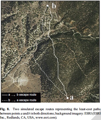
Can technology determine the best escape route for firefighters?

Of the 22 research proposals funded by the Joint Fire Science Program in June, 16 of them were various ways of studying vegetation. At the time we wrote, “It would be refreshing to see some funds put toward projects that would enhance the science, safety, and effectiveness of firefighting.”

A recently completed study is directed toward the firefighters on the ground. The U.S. Forest Service has paid to have researchers study the feasibility of using LiDAR and computers to determine the most efficient and quickest escape routes if firefighters have to withdraw while attacking a wildfire. The LiDAR helped researchers evaluate how landscape conditions, such as slope, vegetation density, and ground surface roughness affect travel rates.

I have a feeling that there will have to be significant advances in portable handheld technology before fire crews in remote areas can take advantage of this type of data. However, who knows, maybe in 10, 20, 30, or 40 years grunts on the ground will have access to sophisticated tools that we can’t even imagine today. They might just speak into a lapel pin to ask for the best escape route, and an augmented reality head-up display or an orbiting drone with a visible laser will designate the path.

Even though the research was paid for by United States taxpayers through the U.S. Forest Service, those same taxpayers will be charged a second time if they want to see the full results of their investment. The fee is $25 to get a copy of the .pdf. It may be available months or years down the road at no additional cost.

The title of the paper is, A LiDAR-based analysis of the effects of slope, vegetation density, and ground surface roughness on travel rates for wildland firefighter escape route mapping.

A year ago the same group of researchers studied how to find and evaluate safety zones in a paper titled, Safe separation distance score: a new metric for evaluating wildland firefighter safety zones using lidar. This research IS accessible to taxpayers without paying a second time.

The recent paper about escape routes was written by Michael J. Campbell, Philip E. Dennison, and Bret W. Butler. Here is a summary of some of their findings.


Every year, tens of thousands of wildland firefighters risk their lives to save timber, forests and property from destruction. Before battling the flames, they identify areas to where they can retreat, and designate the best escape routes to get from the fire line to these safety zones. Currently, firefighters make these decisions on the ground, using expert knowledge of fire behavior and assessing their ability to traverse a landscape.

Now, a University of Utah-led study has developed a mapping tool that could one day help fire crews make crucial safety decisions with an eagle’s eye view.

The new study is the first attempt to map escape routes for wildland firefighters from an aerial perspective. The researchers used Light Detection and Ranging (LiDAR) technology to analyze the terrain slope, ground surface roughness and vegetation density of a fire-prone region in central Utah, and assessed how each landscape condition impeded a person’s ability to travel.

Escape Route wildfire“Firefighters have a great sense for interactions between fire and landscape conditions. We hope to offer to them an extra tool using information collected on a broad scale,” says lead author Michael Campbell, doctoral candidate in the U’s Department of Geography.

Department of Geography professor and co-author, Philip Dennison, adds, “Finding the fastest way to get to a safety zone can be made a lot more difficult by factors like steep terrain, dense brush, and poor visibility due to smoke. This new technology is one of the ways we can provide an extra margin of safety for firefighters.”Continue reading

Research projects funded by Joint Fire Science Program concentrate on vegetation

Joint Fire Science ProgramThe Joint Fire Science Program announced on Friday which research projects are being funded for fiscal year 2017. Of the 22 approved proposals, about 16 of them are various ways of studying vegetation.

It would be refreshing to see more funds put toward projects that would enhance the science, safety, and effectiveness of firefighting.

Click HERE to see the list of approved research projects.