Often on a wildfire we see members of the community displaying signs thanking the firefighters. It is less common to see an organized effort that goes in the other direction — firefighters thanking the community.
On the Roaring Lion Fire southwest of Hamilton, Montana five people representing the first responders and firefighters appeared in a video expressing their appreciation for the support they received from the community.
In the video you’ll see:
Hamilton Fire Chief Brad Mohn
Ravalli County Sheriff Chris Hoffman
Northern Rockies Incident Management Team Incident Commander Greg Poncin
This time-lapse video shows the start of the Roaring Lion Fire and how quickly it grew to become a massive fire in about three hours. It was recorded by Jeff Kempka.
The Roaring Lion Fire, outlined in red, is burning in an area where many other fires have occurred in the last 30 years.
The Roaring Lion fire southwest of Hamilton, Montana did not spread as much Wednesday as on previous days. The latest mapping shows it at 7,752 acres, an increase of 622 acres, with most of that growth being on the south side.
Below is an excerpt from a release by the incident management team Thursday morning:
In the Sawtooth drainage crews are constructing hand line to reduce the possibility of fire spread to the north. From Roaring Lion Road to the Whispering Pine area, crews continue to mop up and extinguish any hot spots. Hotshot crews are working close to the fire’s edge and building hand line above Camas Creek toward Gold Creek. From Camas Creek to Hayes Creek line is being constructed toward the Observation fire area.
Heavy equipment continues to improve contingency lines should the fire continue to spread to the south. Rapid Response teams comprised of engines, dozers and water tenders are staged for initial attack on any new fire starts in residential areas. Air support continues to work hot spots and hot areas of the fire. Firefighters are working around the clock to take advantage of cooler temperatures and higher humidity today.
****
(UPDATED at 8:50 a.m. MDT August 3, 2016)
The Roaring Lion Fire four miles southwest of Hamilton, Montana was very active Tuesday night under the influence of strong winds from the north and northwest. Sustained at 30 to 40 mph with gusts to 50, the wind pushed the fire another mile and a half to the south into the Ward Creek drainage. The fire also grew on the north side. The winds were strongest from 6:30 p.m. on Tuesday until midnight.
Resources assigned to the fire include 9 helicopters and 524 personnel. Single engine and large air tankers are available as needed, but their use was hampered Tuesday by smoke.
3-D Map of the Roaring Lion Fire looking west. The white line was the perimeter at 7 p.m. on August 1. The red line was the perimeter at 2 a.m. on August 3, while the red dots represent heat detected by a satellite at 4:06 am August 3, 2016. Click to enlarge.
The number of homes burned remains at 14. Approximately 50 outbuildings have been destroyed.
About 800 homes are under evacuation orders to either be ready to leave immediately, or to leave now.
One elderly gentleman died as a result of a medical condition during the evacuation.
Over the last 24 hours the fire grew by 2,700 acres to bring the total to 7,130 acres.
US Highway 93 was closed for five hours on Tuesday when smoke reduced the visibility.
Below is a report from KTMF/KWYB just after the Wednesday morning briefing.
The weather forecast for Wednesday predicts much cooler temperatures and higher humidity — 76 degrees and 24 percent (compared to 90 degrees and 17 percent on Tuesday). But the wind will be strong out of the west, at 16 mph gusting to 23.
****
(UPDATED at 6:25 p.m. MDT August 2, 2016)
3-D map of the Roaring Lion Fire looking west at 2:30 a.m. MDT August 2, 2016. The terrain goes from 3,600 feet to over 8,000 feet in elevation.
The strongest winds we wrote about earlier are expected to be at their peak from about 6 p.m. until midnight tonight, gusting at 32 to 38 mph from the northwest.
(Originally published at 7:45 a.m. MDT August 2, 2016)
The Ravalli County Sheriff’s Office has confirmed that the Roaring Lion Fire has destroyed at least 14 homes in the Bitterroot National Forest four air miles southwest of Hamilton, Montana. Since starting Sunday afternoon the blaze had burned approximately 4,400 acres as of 7 p.m. on Monday, growing by about 900 acres over the previous 24 hours. The additional fire spread was primarily on the west and northwest sides.
The red line was the perimeter of the Roaring Lion Fire at 7 p.m. MDT August 1. The red squares represent heat detected by a satellite about 8 hours later at 2:45 a.m. MDT August 2, 2016. Click to enlarge.
The weather on Monday was relatively mild, with temperatures reaching the high 80s and winds of 1 to 7 mph. That will change Tuesday afternoon with a Red Flag Warning affecting the area. The forecast is for 16 to 22 mph west and northwest winds gusting up to 31 mph along with relative humidities in the lower teens. This will test any control lines firefighters have established on the east side of the fire — the area with the highest concentration of structures.
Above: Map of the Roaring Lion Fire. The red line was the perimeter at 3:07 a.m. MDT August 1. The red squares represent heat detected by a satellite at 2:31 p.m. MDT August 1, 2016, showing expansion of the fire to the northwest.
Click HERE to see the most current information on Wildfire Today about the Roaring Lion Fire.
(Update 5:52 p.m. MDT, August 1, 2016)
The Roaring Lion fire in the Bitterroot National Forest outside of Hamilton, Montana has destroyed several structures, although officials have yet to confirm how many, according to posts on InciWeb.
Five hundred homes remain under evacuation notice, and on Monday the fire had burned more than 3,000 acres.
Crews made some gains establishing a fireline on Sunday night, and were aided by 5 helicopters on Monday, according to InciWeb:
Last night, dozer and hand crews were able to punch in containment lines in a good portion of the East side of the fire. They were also able to put out multiple spot fires around residences.
The Type 1 team is expected to take over operations on Tuesday. The cause of the fire remains unknown.
Map of the Roaring Lion Fire at 3:07 a.m. MDT August 1, 2016. Click to enlarge.
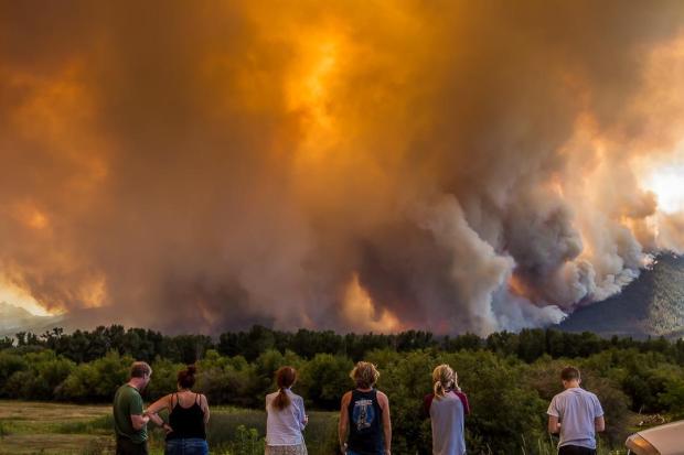
Fanned by hot winds, the Roaring fire exploded in a massive plume of smoke on Sunday. Visit InciWeb to see more photos of the fire. Also, check out this time-lapse video of the fire (note: it will take about 20 seconds for images of the fire to start).
Roaring Lion fire, July 31, 2016
Meanwhile, the Copper King fire in the Lolo National Forest continues to burn, although it has not prompted any evacuations. On Sunday, the fire shut down Montana Highway 200, which officials reopened on Monday.
***
Two wildfires ignited in western Montana on Sunday, prompting evacuations and the shutdown of a U.S. highway.
A Type I incident management team has been ordered to respond to the Roaring Lion fire, which as of Sunday evening had already burned 2,000 acres outside of Hamilton.
A Type II team will be responding to the Copper King fire near Thompson Falls.
2 helicopters, one Single Engine Air Tanker and on Air Attack fixed-wing aircraft.
No structures threatened, and no evacuations, but the fire is very visible from Montana Highway 200.
As of Sunday night, the fire had burned 200 acres.
Strong gusty winds in the area.
Much of western Montana (including the two counties where the fires are, Sanders and Ravalli) has been abnormally dry or experiencing a moderate drought for the month of July, according to the U.S. Drought Monitor.
Montana law enforcement officials have seized a drone that shut down airtanker flights Saturday over the Fritz fire, burning outside of Billings.
The incident comes less than a month after the Federal Aviation Administration sent a mass email to all people who have drones registered with agency asking that they not fly during wildfires.
The email warned that “drone operators who interfere with wildfire suppression efforts are subject to civil penalties of up to $27,500 and possible criminal prosecution.”
The Fritz fire has destroyed at least one home and burned more than 1,000 acres, according to local media reports. As of Sunday, local media said it was at 40 percent containment.
The fire ignited Friday evening, and that night a private drone was spotted flying in the area. The Billings-Gazette reported law enforcement officials took possession of the drone on Friday.
It appears that flight operations were shut down for a half-an-hour.
Drones, like other aircraft, are subject to temporary flight restrictions put in place during a wildfire, according to information from the National Fire Information Center.
“Individuals who are determined to have interfered with wildfire suppression efforts may be subject to civil penalties and potentially criminal prosecution.”
After we inquired, we heard back from Bruce Suenram, Deputy Chief with the Montana Department of Natural Resources and Conservation. He said neither his Department or the County are aware of a large fire in this area.
It looks like a major failure by MODIS; 54 false positive fire detections (most of which had a “high” confidence rating) by the fairly new and highly touted Visible Infrared Imaging Radiometer Suite. The VIIRS 375-meter sensor system on the Suomi-NPP satellite began collecting data late last year.
****
(Originally published at 9:50 MDT July 9, 2016)
Heat detected by a satellite at 1:40 p.m. July 8, 2016.
The MODIS satellite system detected heat Friday afternoon spread over a large area across Highway 191 25 miles north of Big Timber and 12 miles south of Harlowton, Montana. We drew a perimeter around it encompassing over 20,000 acres. It does not show up in the national or regional situation reports.
We are checking to see if this is an actual fire and will update this article if more information becomes available.
The Pole and Fine Fires are burning a mile apart in southwest Montana 18 miles southwest of Ennis and 47 miles northwest of West Yellowstone. The lightning-caused fires were discovered June 30 in stands of standing dead and down timber.
Firefighters are engaging the fires as they move out of the timber stands into meadows in order to minimize exposure to numerous snags.Actions to secure the whitebark pine stand adjacent to the Pole Fire continue.Structure and private property assessments are on-going on the Fine fire.
Vicinity map for the Pole and Fine Fires. Click to enlarge.
The heat-sensing satellites, capable of detecting large concentrations of heat from vegetation fires, has not found any since July 1 at 4:30 a.m.
They yellow icons represent heat detected by a satellite over the Pole and Fine Fires at 4:30 a.m. MDT July 1, 2016. Click to enlarge.