Wildfire potential — August through November

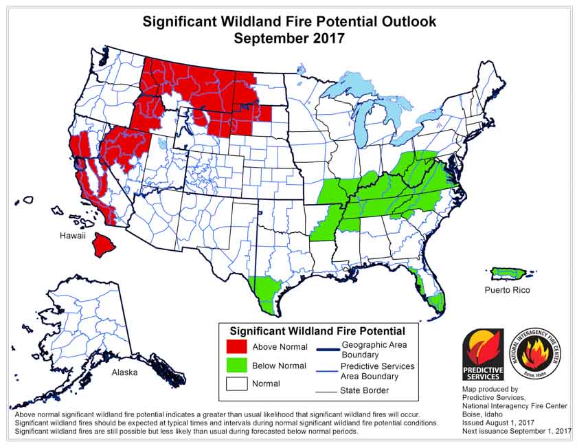
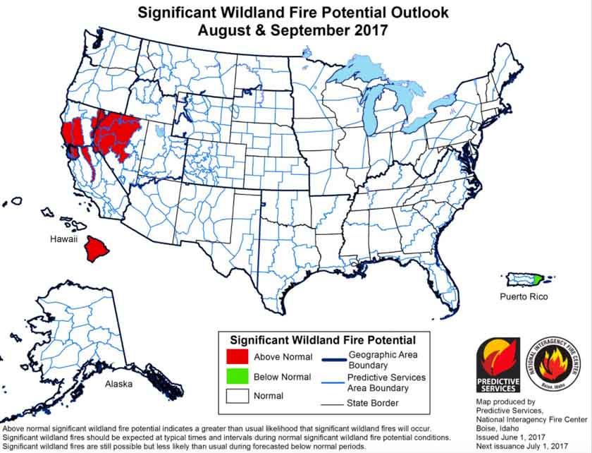
The prediction for August shows enhanced fire potential for the Northern Rockies, Northern Nevada, and much of California and the Northwest.

On August 1 the Predictive Services section at the National Interagency Fire Center issued their Wildland Fire Potential Outlook for August through November. The data represents the cumulative forecasts of the ten Geographic Area Predictive Services Units and the National Predictive Services Unit.

It revises the outlook that was issued for August a month ago, adding to the “Above Normal” category Northern Idaho, the eastern halves of Oregon and Washington, and Western Montana. Many of the August “Above Normal” areas will carry over into September except for the areas in Oregon and Washington.

Below are:

  • the highlights of the NIFC report;
  • NIFC’s graphical outlooks for September through November;
  • Drought Monitor, and;
  • NOAA’s long range temperature and precipitation forecasts.

****

The seasonal transition of the western fire season north has occurred. A strong southwestern monsoon has developed over the Southwest and has reduced the significant large fire potential and activity across the Four Corners Region. Significant lightning activity associated with the monsoon has spread north creating numerous incidents across the northern Great Basin, Northern California, Pacific Northwest, and the Northern Rockies. With the fine fuels now fully cured and with larger fuels now receptive, even at the higher elevations, fire activity is increasing as it nears its seasonal peak in August. While the northwestern states have shown a significant upturn in activity, fire activity in Alaska has begun to wane with the arrival of the late summer rains across the Alaskan Interior. The eastern and southeastern states have seen and will continue to experience overall limited activity as the regions remain largely out of season.

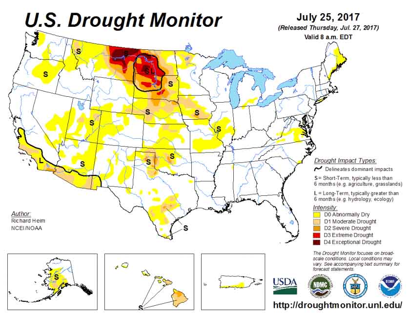
Precipitation received was generally well below average across the western half of the country in July. With the occurrence of three significant heat wave events, fuels dried quickly and became receptive to fire earlier than in most years. By month’s end, the previous winter’s record snowpack and above average spring rainfall was a distant memory. Drought was beginning to reemerge in the Rockies and across portions of the Pacific Northwest. Across the northern Great Plains, the established long term drought conditions continued to worsen. Large fire activity became problematic across eastern Montana, Wyoming and the Dakotas.

Looking forward to the peak of the western fire season in August and September, conditions are expected to remain favorable for the Above Normal significant fire activity to continue. Areas with the greatest potential for significant large fire activity will be the grasses and rangelands of the Pacific Northwest east of the Cascades, the lower and middle elevations across California, most of the Northern Rockies region. The grass and rangelands across the northern Great Basin will also continue to demonstrate Above Normal significant large fire potential and activity.

****

September wildfire potential

October November wildfire potential

****

drought monitor

****

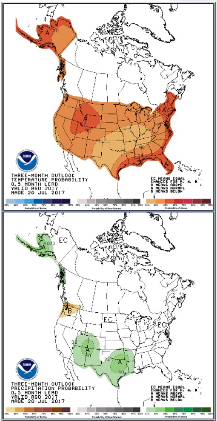
90 day outlook weather

Wildfire potential July through October

Potential wildfire July


On July 1 the Predictive Services section at the National Interagency Fire Center issued their Wildland Fire Potential Outlook for July through October. The data represents the cumulative forecasts of the ten Geographic Area Predictive Services Units and the National Predictive Services Unit.

If it is accurate firefighters could be busy at times in California, the Great Basin, and the Northern Rockies.

Below are:

  • the highlights of the NIFC report;
  • NIFC’s graphical outlooks for July through October;
  • Drought Monitor, and;
  • NOAA’s long range temperature and precipitation forecasts.

****

Fire activity across the West began to increase significantly in June as preexisting dry conditions along with record setting heat events allowed for the fuels to become critically dry across portions of the Southwest, southern Great Basin, and Southern California. By month’s end, fire activity began its usual expansion northward as fires became more frequent in the lower and middle elevations. Several wetting systems slowed fire activity in Alaska. The fire season in Georgia and Florida diminished as multiple wetting rain events relieved the pre existing drought conditions.

Timely precipitation along with above average soil moisture has led to the growth of an abundant crop of fine fuels across much of the west. Periodic cooler than average temperatures across the northwestern portion of the country has slowed curing and drying rates in the grasses and has continued to slow the melting rates of the remaining snowpack. The southwestern states, however, have been drier and more continuously warm than average for several months making fuels more receptive to fire activity. Due to below average precipitation received across the Great Plains portions of eastern Montana and the Dakotas should be monitored closely for a possible increase in fire activity in July. The eastern U.S. been largely milder than average as several frontal systems produced significant rainfall.

Above normal significant fire potential is expected across a large portion of the rangelands of the west through August before trending toward normal in September and October with seasonal changes that bring wetting precipitation. The Southwest can expect a typical end to its fire season as monsoonal moisture becomes more firmly established by the end of July. Higher elevations across northwestern states will continue to experience below normal significant fire potential in July followed by normal potential for August as high elevation heavy fuels begin to dry out. A normal reduction of fire activity is expected in September across much of the west. The eastern half of the nation is in full green-up and fuels are generally not receptive to significant fire activity. Expect these conditions to persist into fall.

wildfire potential August wildfire potential September October

****

Drought Monitortemperature outlook precipitation outlook

Wildfire potential June through September

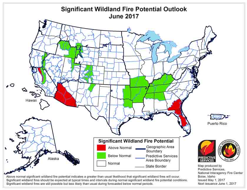
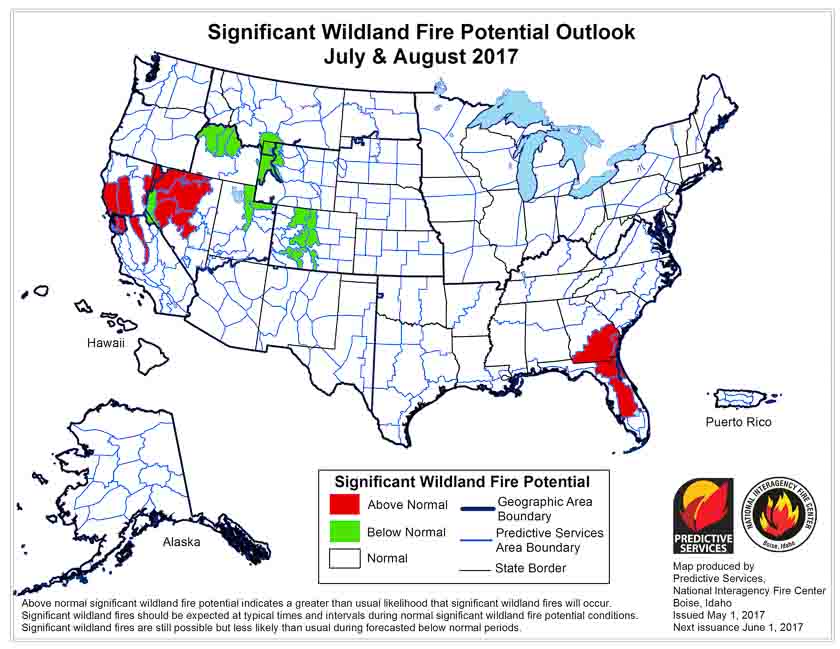
On June 1 the Predictive Services section at the National Interagency Fire Center issued their Wildland Fire Potential Outlook for June through September. The data represents the cumulative forecasts of the ten Geographic Area Predictive Services Units and the National Predictive Services Unit.

If it is accurate it looks like firefighters could be busy at times in Arizona, California, and Nevada, but not so much in the rest of the Western U.S.

Below are:

  • the highlights of their report;
  • NIFC’s graphical outlooks for June through September;
  • the Drought Monitor, and;
  • NOAA’s long range temperature and precipitation forecasts.

****

“Florida and Georgia experienced slight relief during the latter half of May as moderately wet systems produced widespread precipitation in both states. Activity across the southwest including Southern California began to increase toward month’s end as the region began to enter its core fire season. Nationally, the acres burned were above average at the end of May largely due to the fire activity that occurred in early March across the southern Great Plains where more than a million acres burned. The number of fires may be a more reflective number this year and remains below average for 2017.

Above normal precipitation and soil moisture is leading to a robust green-up across the West. Overall cooler than average temperatures and a heavy snowpack have led to slower than normal melting of the mountain snowpack in nearly all locations across the West. This should lead to a delayed start to the fire season in the higher elevations which may, in turn lead to a compressed season.

Above normal large fire potential will continue across southeastern Georgia and Florida into mid-June before the cumulative effects of precipitation events begin to take hold. Below Normal potential is expected across most of the remainder of the southeast through July before returning to Normal for August and September. Recent dry conditions across the southwest will lead to Above Normal potential across southeastern Arizona and Southern California. Below Normal to Normal large fire potential is also expected in the a majority of the higher elevations across the West in June and July.

July and August may be periods of concern. Above Normal potential is expected across the western portion of the Great Basin and across the middle elevations in California in July and August after the abundant grass crop cures. Fire activity will be mostly driven by short term weather events. Looking north, Alaska appears to be transitioning into a normal fire season for June and July with late summer rains ending the season across the interior in August. Extended dry conditions on the west side of the big island in Hawaii will lead to Above Normal potential that should last into September.”

wildfire potential July 2017

wildfire potential August September 2017

Continue reading “Wildfire potential June through September”

Wildfire potential, May through August, 2017

Posted on Categories UncategorizedTags ,

On May 1 the Predictive Services section at the National Interagency Fire Center issued their Wildland Fire Potential Outlook for May through August. The data represents the cumulative forecasts of the ten Geographic Area Predictive Services Units and the National Predictive Services Unit.

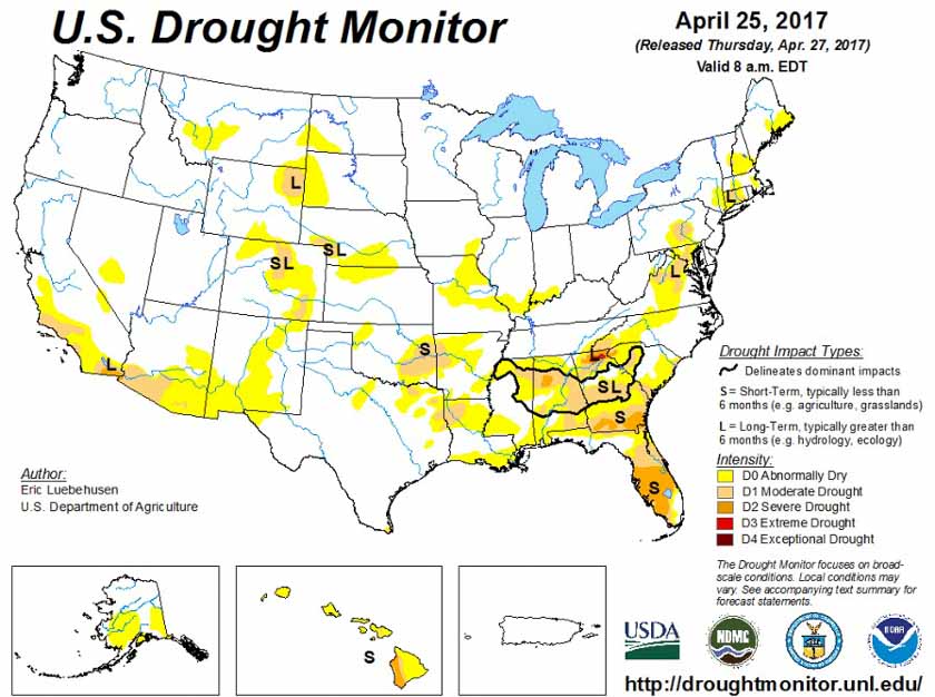
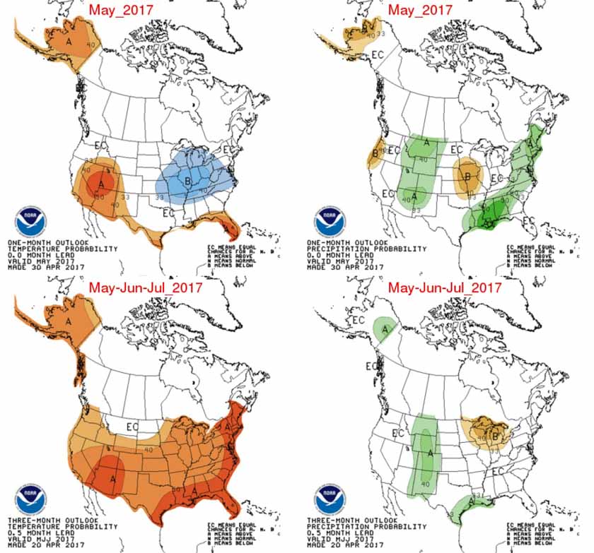
Below are the highlights of their report, NIFC’s graphical outlooks for May through August, the Drought Monitor, and NOAA’s temperature and precipitation forecasts.

Florida and southeastern Georgia continue to experience significant fire activity as warmer and drier than normal conditions persist. Worsening drought conditions in these areas continue to lead to increased fire activity and behavior. Recent precipitation events have not been significant or frequent enough to provide relief. The existing conditions and activity are expected to peak by early June before beginning to show improvement and subside as tropical patterns develop bringing beneficial precipitation.

Wildfire activity across the Southern Plains has begun to wane as the seasonal shift westward begins. Greenup has begun to take hold and precipitation events have become more common across the Central and Northern Plains.

Arizona and western New Mexico will see an increase in fire activity in May and June as the region enters the heart of its fire season. Heavy growth of fine fuels across southern Arizona and southwestern New Mexico have led to above normal fire potential along the Mexican border that should persist through June before the monsoonal rains arrive in early July and decrease activity.

As the fire season progresses into July, there are concerns with the seasonal shift west and north into California, and Great Basin. Exceptional winter and early spring precipitation is leading to the development of a substantial crop of fine fuels in the lower and middle elevations. The heavy loading of fine fuels could become problematic when they cure out in July. In the higher elevations, the mountain snowpack continues to melt at a normal to slower than normal rate. This should produce a delay in the onset of significant fire activity in the high elevations.

In Alaska, the south central portion of the state continues to be abnormally dry. While overall normal fire potential is forecast, bursts of more significant fire activity are possible across the interior portion of the state.

By mid-late July, the western fire season will begin to progress north into the Pacific Northwest and Northern Rockies. While a normal transition into fire season is expected in the lower elevations, a delayed entrance is possible in the higher elevations as both regions enter their fire seasons having seen abundant winter and spring precipitation and snowpack accumulation.

wildfire potential june 2017 wildfire potential july august 2017 Precipitation Temperature outlook map

Wildfire potential, April through July

Posted on Categories UncategorizedTags ,

wildfire potentialOn April 1 the Predictive Services section at the National Interagency Fire Center issued their Wildland Fire Potential Outlook for April through July. The data represents the cumulative forecasts of the ten Geographic Area Predictive Services Units and the National Predictive Services Unit.

Below are the highlights of their report. Following that are NIFC’s graphical outlooks for May through July and NOAA’s temperature and precipitation forecasts.

We also have the NOAA/USDA Drought Monitor which, in the history of our monthly reports, shows no extreme or exceptional drought in California for the first time in years.

****

“Florida and portions of Georgia, South Carolina, Texas and New Mexico continue to experience significant fire activity as warmer and drier-than-normal conditions persist. These conditions will persist as the fire activity peaks across the Southern Plains by May and across Florida through coastal Carolina by early June. Periodic, event-driven pre-green up grassfire activity continues across the central and northern plains and in the lower elevations of the West. This is normal activity and will continue to occur until full green up takes hold. Developing drought conditions across Central Texas and Oklahoma could elevate fire potential in May.

Western New Mexico and Arizona will begin to see an increase in significant fire activity in May before the monsoon begins to develop in late June and begins to curtail activity. As the fire season progresses into June and July, there are concerns with the seasonal shift west into California and north into the central Rockies and Great Basin. Exceptional winter and early spring precipitation will lead to the development of a substantial crop of fine fuels in the lower and middle elevations.

The heavy loading of fine fuels could become problematic when they cure out by July. In the higher elevations, the mountain snowpack is expected to melt at a normal to slower than normal rate due to the abundance of high elevation snow and the occurrence of an overall cool and wet spring. This could produce a delay in the onset of significant fire activity in the high elevations.

In Alaska, the south central portion of the state continues to be abnormally dry which has resulted in a winter snowpack that is below normal.

By mid-late July, the western fire season will begin to progress north into the Pacific Northwest and Northern Rockies. While a normal transition into fire season is expected in the lower elevations, a delayed entrance is possible in the higher elevations.”

****

wildfire potential

wildfire potential

Continue reading “Wildfire potential, April through July”

Wildfire potential, March through June

Posted on Categories UncategorizedTags ,

On March 1 the Predictive Services section at the National Interagency Fire Center issued their Wildland Fire Potential Outlook for March through June. The data represents the cumulative forecasts of the ten Geographic Area Predictive Services Units and the National Predictive Services Unit.

Below are the highlights of their report. Following that are NIFC’s graphical outlooks for April through June, NOAA’s temperature and precipitation forecasts, and the NOAA/USDA Drought Monitor.

****

“A typical transition of fire season activity is expected this spring beginning with the southern tier of the country. Fire activity will increase across portions of the southern plains and along the Atlantic Coast from the Carolinas south through Florida where the heavy loading of dry fuels coupled with warmer and drier than normal conditions is expected to create a potential for above normal fire activity. The increase in fire activity will be most noticed during high wind and low humidity weather events brought on by the seasonal transition from winter to spring. Other locations across the nation will see an increase in pre-green up fire activity as well, but this is not unusual. Southeastern Georgia and Florida may show a more significant increase in fire activity due to the emergence of long term drought conditions. Wetter than normal conditions across the Lower Mississippi River and Tennessee River Valleys are expected to lead to below normal fire potential during March. Look for the areas with below normal potential to be scaled back to mainly Tennessee and Kentucky from April onward as precipitation amounts received decrease to normal levels.

“Entering the latter periods of the outlook, Florida and Southeastern Georgia will remain in an elevated state for fire potential as drought lingers. The Southwestern and Alaskan fire seasons will begin in May as is typical. While normal fire season activity is expected across a majority of both regions, there are areas within both regions where an elevated potential for fire activity exists. Areas along and east of the Continental Divide in New Mexico have been and are expected to experience warmer and drier than normal conditions. In Alaska, the south central portion of the state has been abnormally dry which has resulted in a winter snowpack that is below normal. Given expected warm and dry conditions in May and June, an above normal potential for fire activity is expected to exist. Below normal fire potential is expected across the Central Rockies and the Sierra Mountains along the California-Nevada State line where the abundant winter snowpack should translate to a later than normal melt-off which could delay the start of the western fire season in the higher elevations.”

****

wildfire potential April 2017 wildfire potential May June 2017

**** Continue reading “Wildfire potential, March through June”