Wildfire potential, January through April

With huge amounts of rain and snow hammering California and Oregon, few people in those areas are thinking about wildfires this week.

But in spite of the rain delivered to the west coast on what meteorologists are calling an “atmospheric river”, on January 1 the Predictive Services section at the National Interagency Fire Center issued their Wildland Fire Potential Outlook for January through April. The data represents the cumulative forecasts of the ten Geographic Area Predictive Services Units and the National Predictive Services Unit.  If their predictions are correct, in February wildfire activity could begin to pick up in parts of Texas, Oklahoma, Kansas, and New Mexico, with Florida and Georgia getting busier in March and April.

Below are the highlights of their report. Following that are outlooks for February through April, temperature and precipitation forecasts, and the Drought Monitor.

****

“To begin 2017 significant wildland fire potential will be normal throughout entirety of the United States, except for below normal in Puerto Rico. For the majority of the U.S. this normal condition means that significant wildland fires are unlikely and normal indicates an out of fire season condition.

Beginning in February the seasonal increase in wildland fire activity will begin in the southern plains where the combination of abundant fine fuels and the potential for dry and windy conditions will occasional come together to produce periods of significant fire activity impacting the Southwest, Rocky Mountain and Southern Areas.

After February predictions for significant fire activity become increasingly difficult. It is likely that the same fire potential will continue across the southern plains, but pregreen up fires will also become increasingly likely in a large portion of the U.S. These fires are difficult to predict and rely on short term localized significant weather events.

Also during this period it is likely that we will see the onset of fire activity in south central Alaska, where warmer and drier than typical winter conditions are occurring.

Significant fire potential will also increase to above normal in Florida and portions of Georgia. Long term drought remains the primary concern in this area and moisture deficits in this area are likely to lead to occasional fires that burn deep into the soil layer and are more difficult to suppress.”

****

Continue reading “Wildfire potential, January through April”

Wildfire potential, December through March


On December 1 the Predictive Services section at the National Interagency Fire Center issued their Wildland Fire Potential Outlook for December through March. The data represents the cumulative forecasts of the ten Geographic Area Predictive Services Units and the National Predictive Services Unit.

If their predictions are correct, the elevated wildfire danger that has plagued the southern states for weeks will be returning to normal. From January through March their analysis shows no areas with above normal wildfire potential.

January wildfire outlook

Continue reading “Wildfire potential, December through March”

Wildfire potential, November through February

On November 1 the Predictive Services section at the National Interagency Fire Center issued their Wildland Fire Potential Outlook for November through February. The data represents the cumulative forecasts of the ten Geographic Area Predictive Services Units and the National Predictive Services Unit.

If their predictions are correct, firefighters in the southeast and in southern California could see significant wildfire activity in November and December.

wildfire potential november

Scroll down to see additional wildfire potential maps, the drought monitor, and the 90-day temperature and precipitation outlooks, but immediately below are highlights from the wildfire potential outlook.

****

November significant wildland fire potential is generally very minimal throughout the northern tier of the U.S. as conditions transition out of normal fire season. Areas of the Great Basin and Rocky Mountains that are currently seeing increased levels of fire activity are likely to see much of that activity diminish and transition to out of season conditions through early November.

Exceptions will continue in Southern California where long term drought is still in place. Conditions in this area will slowly transition to normal from north to south through the Outlook period. Normal implies a significant reduction in fire activity, but some fires should still be expected. Also, the southeastern U.S. will continue to see a large area of above normal significant fire potential for November and December that will slowly transition back to normal through the Outlook period as well. This condition is also largely due to long term drought that is going to be exacerbated by dry leaf litter falling on top of already dry fuels and also occasional dry and windy periods. For the southern Plains there is a plentiful grass crop that presents the potential for occasional dry and windy periods to increase fire activity.

Normal winter conditions will prevail across the U.S. in January and February. There will be occasional periods of increased fire activity, but these will be infrequent and difficult to predict accurately. During this outlook period winter precipitation and snowpack development will be a critical situation to monitor as the 2017 fire season becomes the focus of many fire managers.

****

wildfire potential december

wildfire potential january february

Continue reading “Wildfire potential, November through February”

Wildfire potential, October through January

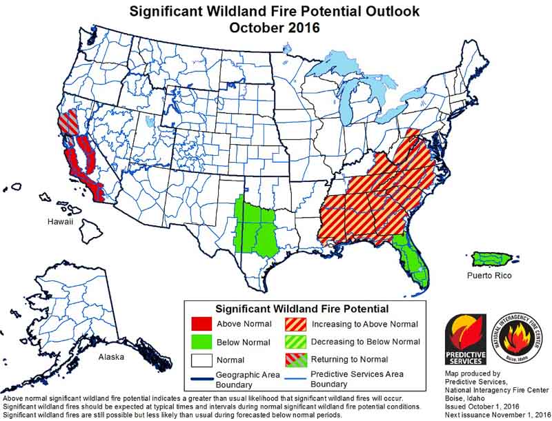
On October 1 the Predictive Services section at the National Interagency Fire Center issued their Wildland Fire Potential Outlook for October through January. The data represents the cumulative forecasts of the ten Geographic Area Predictive Services Units and the National Predictive Services Unit.

If their predictions are correct, firefighters in the mountains of central and southern California could be busy through November, at least, while most of the Southeast is coming into what could be a very active fall fire season.

wildfire potential

Scroll down to see 6 to 14-day temperature and precipitation outlooks, and Red Flag Warnings for October 2, but immediately below are highlights from the wildfire potential outlook.

****

“October represents a significant shift in fire activity in the United States. Shorter days, cooler nights and generally moister conditions reduce wildfire activity across the northern tier of the U.S., taking much of this area out of season or at least to very low fire activity conditions.

“October does represent the beginning of the primary time of concern for offshore flow across California. These dry windy conditions can lead to very significant fire events in areas with high populations. This year the forecasts indicate that offshore wind events may be less frequent than usual. However during even light wind periods fires will occur and they will have the potential to spread extremely quickly with extreme fire behavior. Fuels continue to be very dry in California due to long term drought and increased vegetation stress and mortality. Under windy conditions these fuels will become extremely volatile and can support extreme fire behavior.

“October also marks the start of the fall fire season across the eastern U.S. Leaf drop begins and adds a new dry layer of fuel. In seasons such as this one where leaf drop occurs on already dry fuels, fire activity can be amplified. Expect this to lead to increased initial attack activity and probably a slight increase in large fires. Fire activity occurs year round in the southeastern U.S. so the most likely scenario is to see an increase in frequency and the potential for more control problems than usual on fires this fall.

Continue reading “Wildfire potential, October through January”

Wildland fire potential, September through December

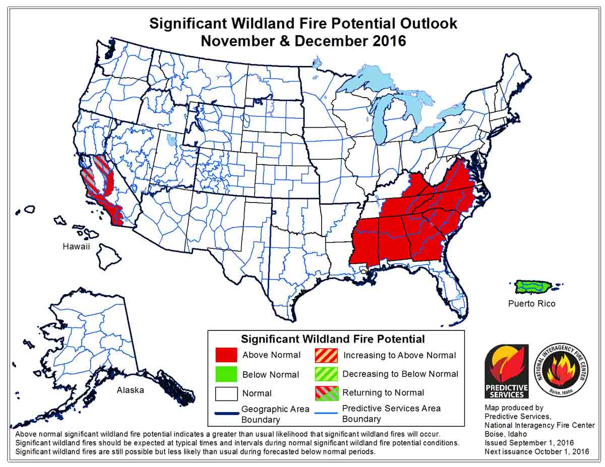
On September 1 the Predictive Services section at the National Interagency Fire Center issued their Wildland Fire Potential Outlook for September through December, 2016. The data represents the cumulative forecasts of the ten Geographic Area Predictive Services Units and the National Predictive Services Unit. Below are highlights from the outlook.

****

September is typically a month of significant change in fire conditions, especially across the northern tier of the United States. Days shorten, lessening available solar radiation to dry and heat fuels; longer nights are cooler with generally higher humidity. These conditions slowly reduce fire activity and typically end normal fire season activity throughout the month. This is expected to be the trend this season as well.

Throughout the northern portions of the Great Basin including portions of the Northwest, Northern Rockies and Rocky Mountain Areas above normal conditions will transition through the month to normal conditions and by the end of September normal conditions indicate minimal fire activity throughout this area. Occasional dry cold fronts during September and possibly October will present the potential for large fires on the landscape to grow rapidly; however, these conditions will be short in duration followed by opportunities for successful firefighting efforts. California will remain at above normal levels of fire activity throughout much of the state as dry conditions will continue and fall will bring the increased potential for offshore flow events.

wildfire potential

In October, November and December diminishing activity in the northern tier will transition to heightened activity across the southern tier; especially in central and southernCalifornia and the Southeast. California is not expected to see any significant events that will alleviate long term drought and very dry fuels. This will come with enhanced potential for offshore flow, increasing the potential for very dry and windy conditions. The southeastern United States is a significant wildcard moving into the fall months.

Tropical systems the Atlantic Ocean and Gulf of Mexico could provide substantial relief to some if not all of the area.

If this dry area remains, fall fire activity in the Southeast will be amplified and could become significant throughout the fall and winter. It is possible significant changes will occur, but the current conditions dictate elevated potential is likely.

wildfire potential

Wildland fire potential in the lower 48 states

The U.S. Forest Service produced this map showing wildfire potential in the lower 48 states. Higher resolution versions are available.

Here is how the USFS describes this map:

“The wildland fire potential (WFP) map is a raster geospatial product produced by the USDA Forest Service, Fire Modeling Institute that is intended to be used in analyses of wildfire risk or hazardous fuels prioritization at large landscapes (100s of square miles) up through regional or national scales. The WFP map builds upon, and integrates, estimates of burn probability (BP) and conditional probabilities of fire intensity levels (FILs) generated for the national interagency Fire Program Analysis system (FPA) using a simulation modeling system called the Large Fire Simulator (FSim; Finney et al. 2011).

The specific objective of the 2012 WFP map is to depict the relative potential for wildfire that would be difficult for suppression resources to contain, based on past fire occurrence, 2008 fuels data from LANDFIRE, and 2012 estimates of wildfire likelihood and intensity from FSim. Areas with higher WFP values, therefore, represent fuels with a higher probability of experiencing high-intensity fire with torching, crowning, and other forms of extreme fire behavior under conducive weather conditions.

Using the FPA FSim products as inputs, as well as spatial data for vegetation and fuels characteristics from LANDFIRE and point locations of fire occurrence from FPA (ca. 1992 – 2010), we used a logical series of geospatial processing steps to produce an index of WFP for all of the conterminous United States at 270 meter resolution.”