Wildfire potential, April through July, 2012

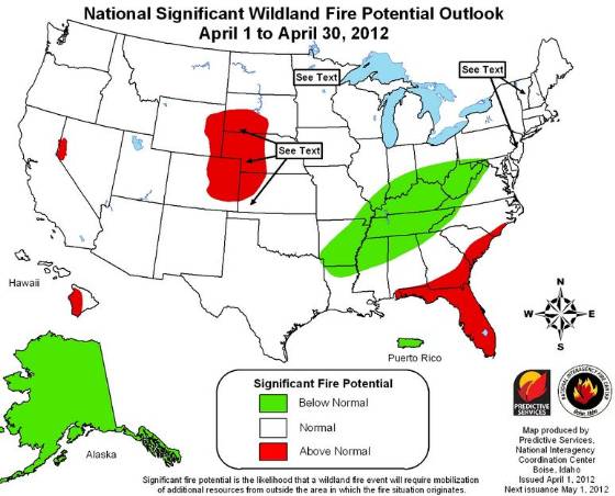
Monthly Wildfire Outlook April 2012

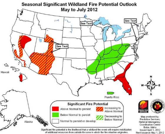
The Predictive Services section at the National Interagency Fire Center has issued their National Wildland Significant Fire Potential Outlook for April through July, 2012. If correct, Arizona, New Mexico, Florida, and portions of California and Nevada will experience above normal wildfire potential for the months May through July.
Monthly Wildfire Outlook April 2012
Seasonal Wildfire Outlook May-July 2012

Below is a summary of the wildfire potential:

Significant Fire Potential

  • Above Normal Significant Fire Potential is expected along the east coast from near Wilmington, North Carolina, to near Panama City, Florida, including all of the Florida peninsula; most of northwestern Nevada; foothills and inland valleys of southern California; and the lee side of the Hawai’in Islands.
  • Significant Fire Potential will increase to above normal in the spring across most of Minnesota, northern Wisconsin, the upper peninsula of Michigan and northwestern Iowa; central and western New Mexico, most of Arizona, southern Nevada, far southern Utah and extreme southwestern Colorado.
  • Below Normal Significant Fire Potential is expected for much of the Ohio and Tennessee Valleys, the middle and lower Mississippi Valley, and Puerto Rico. The rest of the country will have normal significant fire potential.

Climate and Drought Conditions

  • La Niña will continue to weaken as oceanic trends point to warming of the equatorial Pacific through spring, favoring a neutral or weak El Niño cycle by early summer.
  • Warmer than normal temperatures are expected across much of eastern two-thirds of the U.S.in March and transitioning to above normal across just the southern half of the country. Below normal temperatures are expected for the West coast and much of Alaska.
  • Precipitation is expected to be below median for most of the southwest, central and southern Plains, and the Gulf coastal region including all of Florida, and southern Alaska. Above median precipitation is expected for the Northwest and northern Rockies, the Upper Midwest, theGreat Lakes region, and the Ohio and mid-Mississippi valleys.
  • Drought will persist through much of the lower Atlantic and Gulf coasts, most of the southwestern and south central U.S., most of central and northern California, the western Great Basin, and the upper Mississippi valley. Drought will likely develop across the northern Plains, the eastern Great Basin and central Rockies, and southern California. There will be some improvement in the Northwest, parts of northern California, east Texas, and on the lee sides of the Hawai’in Islands.

Wildfire potential, March through June, 2012

Wildfire outlook April-June, 2012

The Predictive Services section at the National Interagency Fire Center has issued their National Wildland Significant Fire Potential Outlook for March through June, 2012. The eastern United States should experience temperatures much above normal in March, and drought conditions are predicted for the southwest, the southeast, and Minnesota through May.

Below is a summary of the wildfire potential:

  • Above Normal Significant Fire Potential is expected along the east coast from near Wilmington, North Carolina, to near Panama City, Florida, including all of the Florida peninsula; most of northwestern Nevada; foothills and inland valleys of southern California; and the lee side of the Hawai’in Islands.
  • Significant Fire Potential will increase to above normal in the spring across most of Minnesota, northern Wisconsin, the upper peninsula of Michigan and northwestern Iowa; central and western New Mexico, most of Arizona, southern Nevada, far southern Utah and extreme southwestern Colorado.
  • Below Normal Significant Fire Potential is expected for much of the Ohio and Tennessee Valleys, the middle and lower Mississippi Valley, and Puerto Rico.
  • The rest of the country will have normal significant fire potential.

Wildfire outlook, March, 2012

Wildfire outlook April-June, 2012

(More maps are below)Continue reading

Wildfire potential, February through May, 2012

Monthly wildfire outlook

The Predictive Services section at the National Interagency Fire Center has issued their National Wildland Significant Fire Potential Outlook for February through May, 2012. According to their prediction, several areas of the United States will have above normal wildfire potential during this period.

Wildfire outlook, February, 2012

Seasonal wildfire outlook, March-May, 2012

Here is an excerpt from their report:

================================================================

La Niña: La Niña remains at near moderate strength and is expected to slowly weaken during the spring months. Classic weather patterns of wet and cold in the northwest and warm and dry in the south are expected, although intensity of these cannot be directly correlated to the strength of La Niña.

Drought: Significantly above normal precipitation fell January across parts of West and North Texas and southern Oklahoma. The Northwest also received significant precipitation. However, large parts of the Southwest and the Plains states remained much below normal. Severe to exceptional drought continues across the south central and far southeastern parts of the U.S. and over parts of the upper Mississippi valley.

Fuel Dryness: Late January and early February have brought a transition to much of the U.S. The southern tier continues to see drier than normal conditions, except across some portions of Texas, where precipitation is moistening fuels even though drought conditions remain prevalent. Also, tree mortality from drought will continue to be problematic. Across much of the west, including the Great Basin fine fuels remain heavy and continuous and are largely dry or capable of quickly drying. Significant fires will be possible with the combination of ignitions and windy conditions. The formerly dry Northwestern quarter of the country has begun to see significant moistening and snowpacks are beginning to increase. In the east the northern tier will largely be near normal seasonal fuel conditions with some dryness lingering across the Great Lakes states. The southeast will continue drier than normal fuels conditions south and east of the Tennessee Valley.


Wildfire potential, January through April, 2012

wildfire monthly_outlook 1-2012

The Predictive Services section at the National Interagency Fire Center has issued their National Wildland Significant Fire Potential Outlook for January through April, 2012. According to their prediction, most of the United States is in for a quiet first part of the year with the exception of parts of Minnesota, New Mexico, Texas (as usual), Georgia, South Carolina, and Florida.

wildfire monthly_outlook 1-2012

wildfire seasonal outlook 1-2012

According to NIFC, the primary factors influencing these outlooks are:

  • La Niña: La Niña conditions will continue over the tropical Pacific and typical weather patterns will return to the US after intraseasonal circulations disrupted the classic La Niña patterns over North America in December.
  • Drought: Significantly above normal precipitation fell in December over parts of the front range of the southern Rockies, the central Plains and the Ohio Valley. Parts of central and west Texas, southwest New Mexico and southern Arizona also received above normal precipitation. Much of the West, the central and southern Rockies, the northern Plains and Florida received less than 50 percent of normal precipitation for the month.
  • Fuel Dryness: Fuel conditions continue to improve across most of the U.S. As winter progresses and La Niña returns the northern tier of the country will see fuel conditions that are not conducive to significant fires. The far southern portions of the country, however, will begin to experience drier and warmer periods as La Niña sets in. Even though these will not be as strong as last year, expect fuels conditions to dry significantly and support significant fires across the Southwest and the far Southeast.

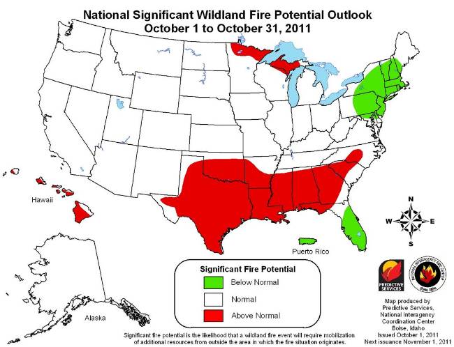
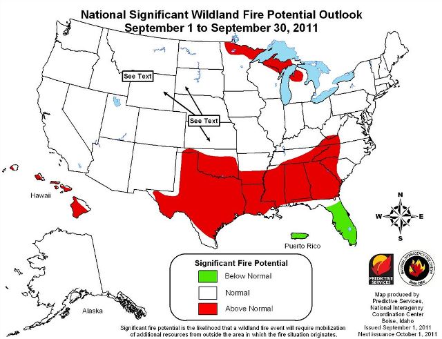
Wildfire potential, October 2011 through January 2012

Wildfire outlook November 2011 through January 2012

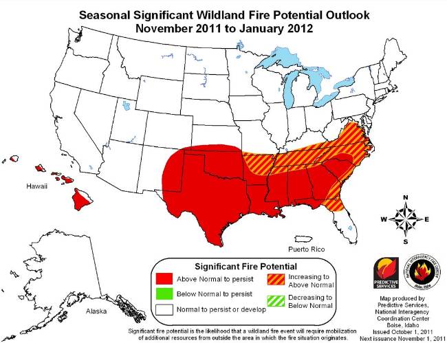
The Predictive Services section at the National Interagency Fire Center has issued their National Wildland Significant Fire Potential Outlook for October, 2011 through January, 2012. According to their prediction, most of the United States is in for a quiet autumn and early winter with the exception of the southeast.

Wildfire outlook October 2011Wildfire outlook November 2011 through January 2012

According to NIFC, the primary factors influencing these outlooks are:

  • La Niña: La Niña conditions have redeveloped, as evidenced by a marked cooling of the equatorial Pacific. It is not unusual to have a second La Niña after one of such magnitude as the 2010-11 event. However, the impacts may be greater given the degree of drought across much of the south central and southeastern U.S.
  • Drought: Extreme to exceptional drought will persist across Texas, eastern and southern New Mexico, Oklahoma, southern Kansas, western Louisiana, Georgia and western South Carolina.
  • Fuel Dryness: A significant change in fuel conditions occurred across much of the west in the latter part of September. Cooler temperatures and increasing humidity coupled with shorter days and burning periods caused indices and fuel moistures to dip to normal or below normal. Even with short warming and drying periods much of the West will not return to any significant conditions or level of concern this season. The exception may be Southern California where near normal conditions currently exist and offshore wind events remain possible through the fall. Drought conditions persist across a portion of the Great Lakes region, however with recent moisture and decreasing temperatures, fuels will not likely recover to the point of causing above normal significant fire potential after the early portion of October. Drought will persist and worsen across much of the southern U.S. from Texas through North Carolina. With leaf fall already underway and significantly below normal precipitation likely, fuel conditions will continue to be critical. The lee side of the Hawaiian Islands will also remain in a drought and fuels conditions will continue to be dry.

Previous wildfire potential outlooks.

And, don’t forget about the fire weather forecast for the next 10 years we posted earlier.

Wildfire potential, July through October, 2011

Seasonal wildfire outlook, August-October, 2011

The Predictive Services section at the National Interagency Fire Center has issued their National Wildland Significant Fire Potential Outlook for July through October, 2011. If this turns out to be accurate, it looks like there will be average or below average wildfire potential beginning in July, except for Texas — of course. When it comes to wildfires over the last 8 months or so, if it were not for bad luck, Texas would have no luck at all.

Firefighters in Arizona and New Mexico have both been extremely busy during the last 30 days, with both states experiencing record-breaking fires, larger than any in recorded history. Here’s what the outlook says about that area:

Southwest: Above normal significant fire potential is expected across the northwestern one-third to one-half of Arizona as well as sections of northwestern New Mexico in July. Much of the remainder of the Southwest will transition from above normal to normal during the first 7-10 days of the month. Seasonal trends indicate moisture under the subtropical ridge will produce periods of increased rainfall over the region. However, conditions in the northwestern parts of both Arizona and New Mexico may linger in high fire potential past mid-month until deeper moisture and precipitation can migrate to those areas and reduce the threat. Temperatures are expected to be above normal for most of the area while precipitation is expected to be normal with slightly below normal over western Arizona.

Normal significant fire potential is expected for the entire Southwest for August through October. Normal to slightly above normal monsoon activity could produce above normal precipitation for the period, especially near the continental divide and eastward. The western Arizona lowlands could see normal precipitation. Temperatures are expected to be normal to slightly above normal through the period.

Seasonal wildfire outlook July, 2011
Seasonal wildfire outlook, August-October, 2011

Wildfire potential, June through September, 2011

monthly wildfire potential outlook

Today the Predictive Services section at the National Interagency Fire Center issued their National Wildland Significant Fire Potential Outlook for June through September, 2011. If this turns out to be accurate, it looks like it will be a quiet or average summer season for the United States, with the exception of portions of Arizona, New Mexico, west Texas, central Alaska, and Florida.

The primary factors influencing these outlooks are:

  • La Niña: La Niña continues to weaken with neutral conditions expected by July. However, soil moisture extremes resulting from La Niña will continue to affect temperature and precipitation patterns through the season. Temperatures will generally be below average with above average precipitation in areas where soil moisture is significantly above normal, until.
  • Drought: Drought will continue across much of the southern third of the U.S. with some improvement expected along the Gulf Coast and in parts of Texas and the Southwest.
  • Fuel Dryness: Fuel conditions across the southern tier of states are expected to continue to be dry through June, gradually improving across west Texas, the Gulf Coast and Florida as the month progresses. Across the northern tier heavy snow and precipitation this spring has delayed green up and curing, generally delaying the onset of fire season.

monthly wildfire potential outlook

seasonal wildfire potential outlook

Below is the latest version of the Drought Monitor:

Drought Monitor 5-24-2011