July could bring elevated wildfire potential to parts of the west coast, Alaska, Arizona, and the Southeast

Moderate to severe drought conditions exist in western Oregon and Washington

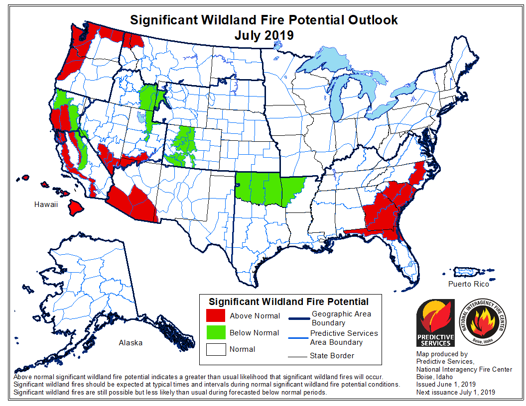
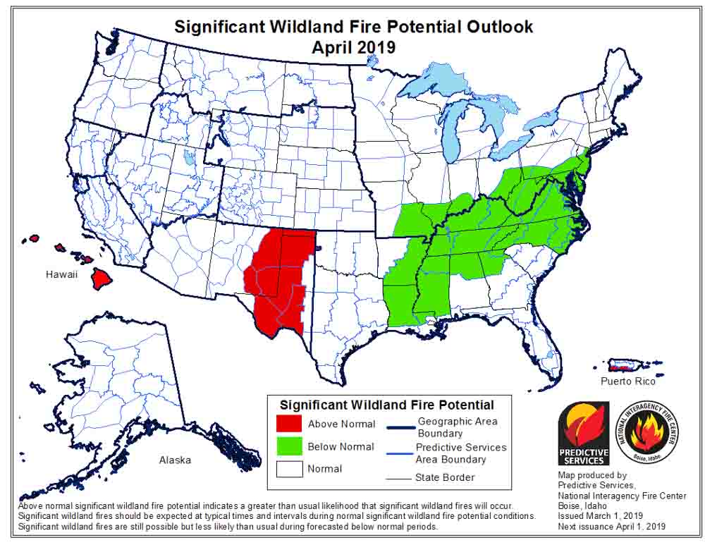
wildfire outlook 2019 July

On July 1 the Predictive Services section at the National Interagency Fire Center issued their Wildland Fire Potential Outlook for July through October. The data represents the cumulative forecasts of the ten Geographic Area Predictive Services Units and the National Predictive Services Unit.

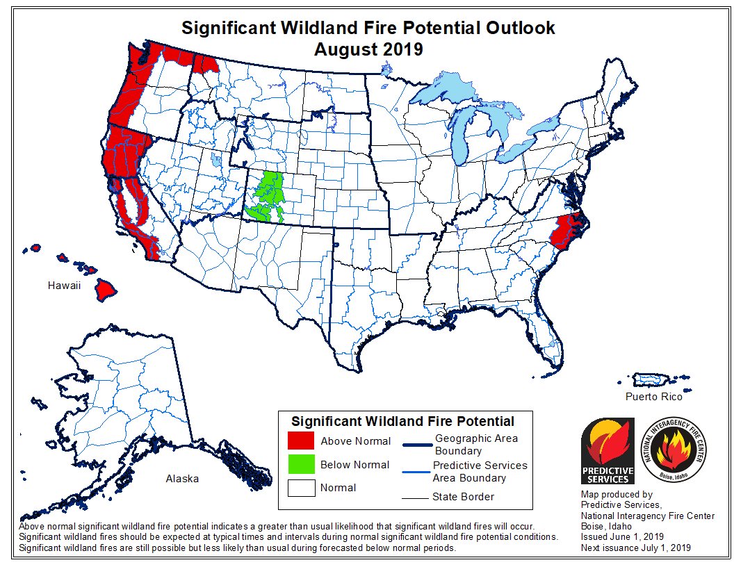
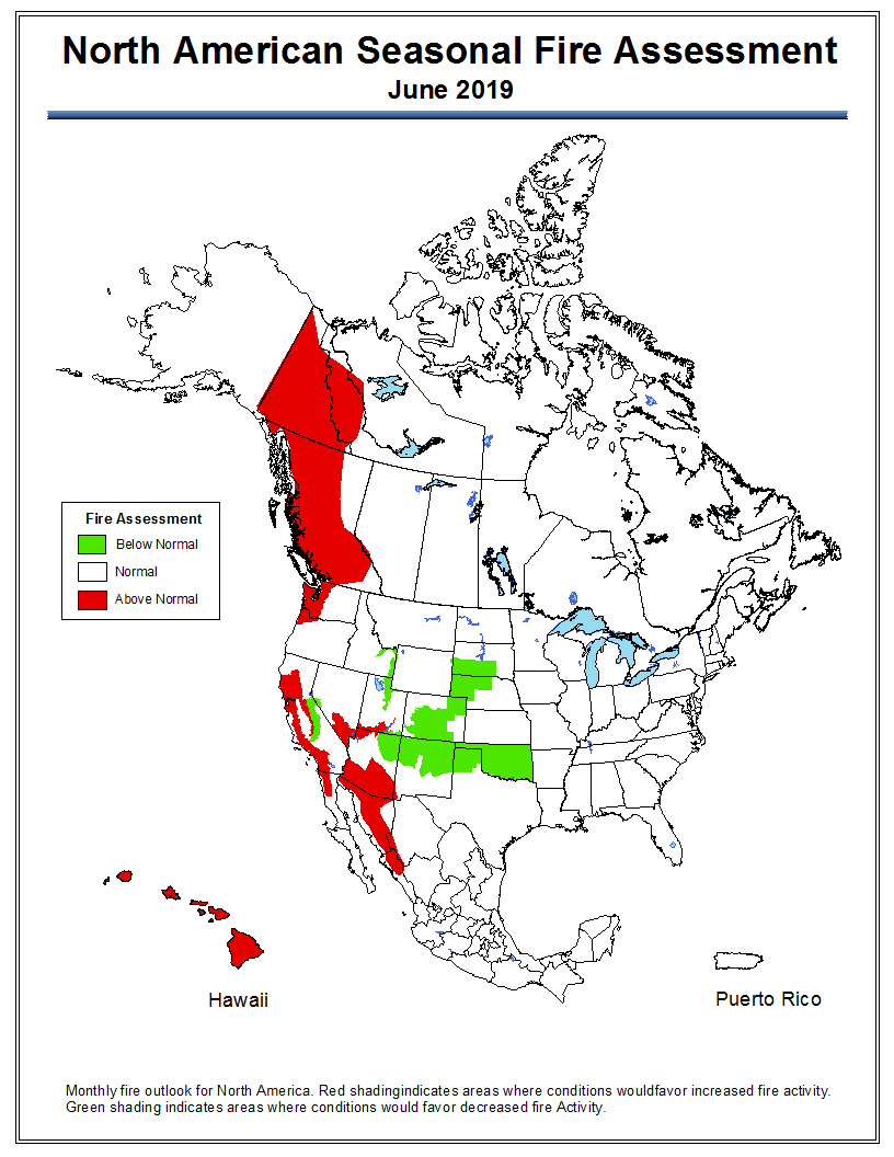
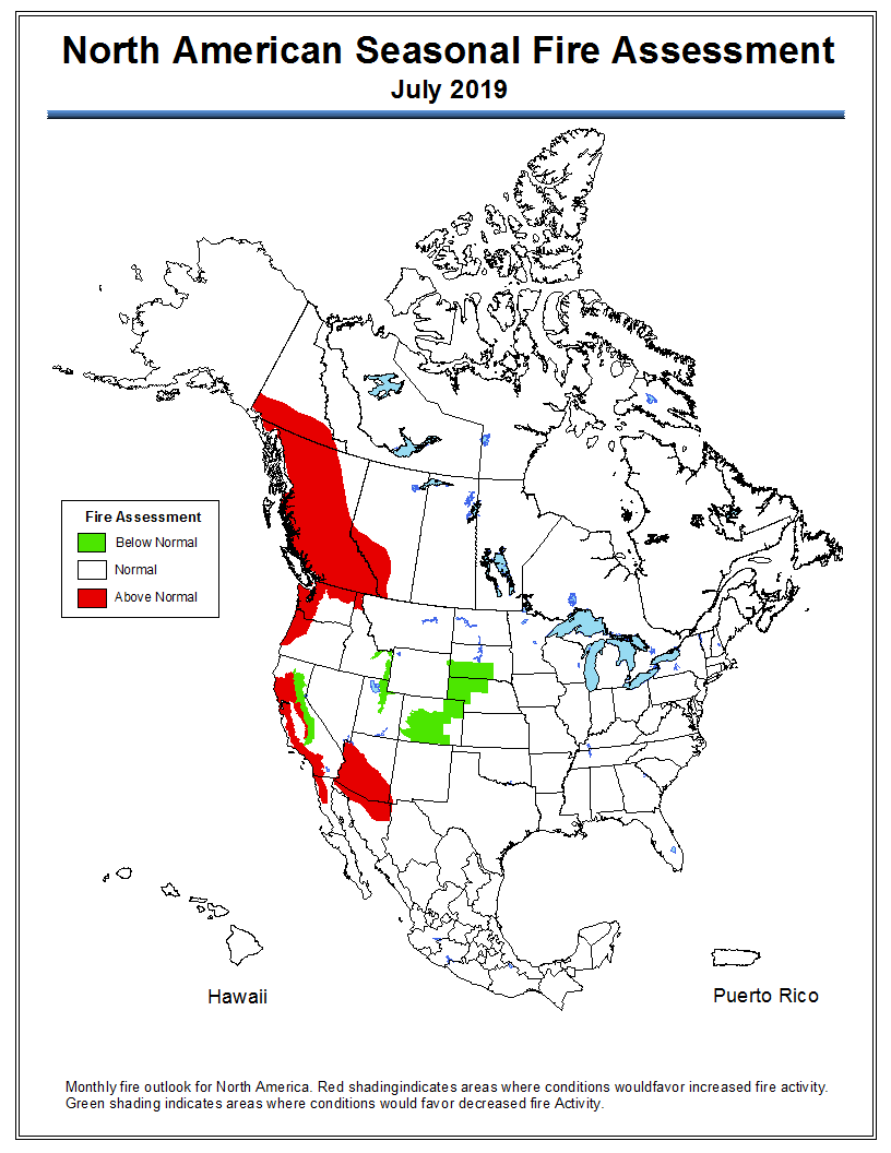
If NIFC’s analysis is correct, areas in California, Washington, Oregon, Arizona, Alaska, and California will have elevated potential for wildfires at times during the four month period. Forecasters predict portions of Florida, Georgia, and the Carolinas will have enhanced potential in July.

The areas affected by the multi-year drought in the West have greatly decreased to the point where there are no locations with extreme or exceptional drought. No areas in California are listed as being in drought status, which is a major change from five or six months ago.

Below:

  • An excerpt from the NIFC narrative report for the next several months;
  • More of NIFC’s monthly graphical outlooks;
  • NOAA’s three-month temperature and precipitation forecasts;
  • Drought Monitor;
  • Vegetation greenness map.

From NIFC:

“Moderate to severe drought conditions exist across Washington and Oregon, especially across western portions of both states. Soil moisture levels are drier than average and drought stress exists. Another area of concern is southern Arizona. While fuel conditions across most of the Southwest exhibit above average fuel moisture and greenness, the southern third of the state is the anomaly. Areas along and north of the Mexican Border remain persistently dry. Periodic wind events have led to critical periods with above normal activity observed. This area will remain a concern until the monsoon arrives in July.

“Alaska experienced a slow entry into its season. By mid-June fire activity increased significantly as fuels continued dried. Numerous lightning events produced a significant number of fire starts. The consistent warm and dry pattern observed at month’s end suggested that the state will continue to be active well into July before the season begins to wind down with the arrival of late summer rains in August.

“In California, robust crop of grasses has grown. The fuel beds have become more continuous than what is typically seen. When the hot, dry, and windy patterns develop during the middle to late summer months, the large fire potential in these areas will elevate. In the higher elevations, the abundant moisture received translated into historic snowfall. This and slow melting rates will translate into a delayed entry into the fire season. To the east, concerns across the Great Basin are rising due to heavy fuel loading and an expected long-duration heat event in early July that should propel the region into fire season.

“With fine fuels fully cured across the West and high elevation larger fuels becoming adequately dry in August, fire season 2019 will peak in August across much of the West. Exceptions to this will be the Southwest where an ongoing monsoon reduced fire activity and the central Rockies, which may not have enough time to fully dry and cure before monsoonal moisture, begins to affect the region.

“A gradual decrease in fire activity is expected to begin by mid-September as the seasonal transition begins and as shortening days translate to shorter burn periods and better overall humidity recoveries overnight. California will begin to reenter fire season in October as East and North wind events begin to occur.”
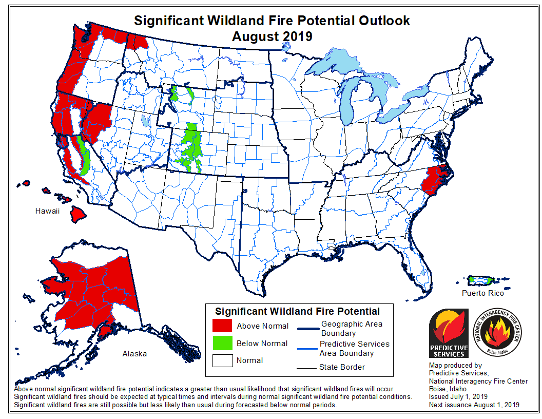

wildfire outlook 2019 August
Continue reading “July could bring elevated wildfire potential to parts of the west coast, Alaska, Arizona, and the Southeast”

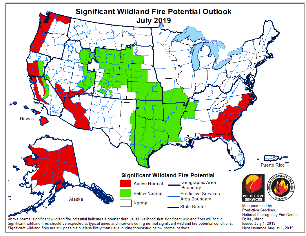
Forecasters predict the potential for large wildfires will be higher than average on the west coast this summer

Areas to watch will be Northern California and the west sides of Oregon and Washington

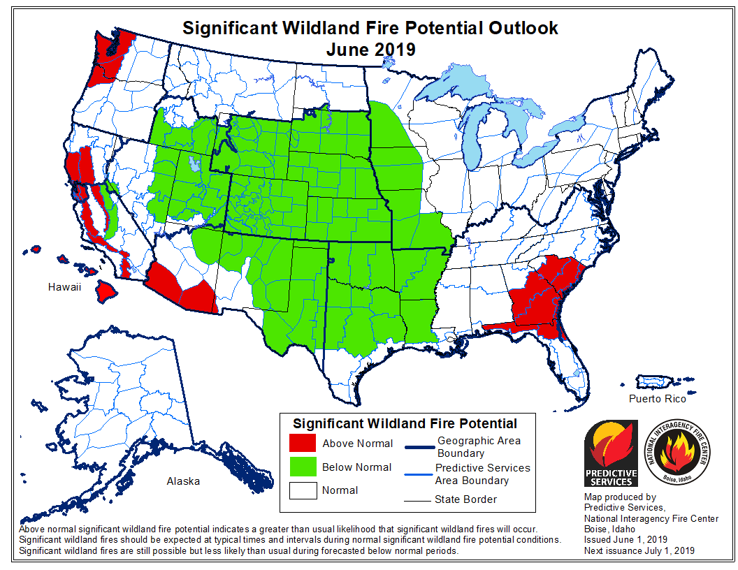
June wildfire potential

On June 1 the Predictive Services section at the National Interagency Fire Center issued their Wildland Fire Potential Outlook for June through September. The data represents the cumulative forecasts of the ten Geographic Area Predictive Services Units and the National Predictive Services Unit.

If NIFC’s analysis is correct, the areas with above normal wildfire potential on the western sides of Washington, Oregon, and California will expand during the four-month period until they cover most of the forested lands in California as well as northern Washington and Idaho. Forecasters predict portions of Florida, Georgia, and the Carolinas will have enhanced potential in June and July.

The areas affected by  the multi-year drought in the West have greatly decreased to the point where there are no locations with extreme or exceptional drought. Northwestern Oregon is classified as “severe drought” and this could be an area to watch over the summer months.

Below:

  • An excerpt from the NIFC narrative report for the next several months;
  • More of NIFC’s monthly graphical outlooks;
  • NOAA’s three-month temperature and precipitation forecasts; and,
  • Drought Monitor.
  • Vegetation greenness maps

From NIFC:
“…As June progresses, the fine fuels will begin to cure and dry from south to north across the West. Lingering high elevation snowpack should be lost. Wildfire activity should begin to increase by late month as peak of the fire season begins to arrive as July and August approach. As is the case with the lower elevation fuels, the high elevation heavy fuels will also experience a delayed entry into the season except along the Canadian Border in Washington State where overall dryness will lead to an average start with a potential for above normal activity. Alaska will reach its peak in June and begin to wind down in July.

“Looking ahead to August and September the fire potential and resulting activity should increase to Normal in most areas except along the West Coast where Above Normal significant large fire potential is expected due to fuel loading and preexisting dry conditions. A traditional winding down of the Western fire season is expected in Mid-September as fall moisture begins to arrive…”

July wildfire potential

August wildfire potential

Continue reading “Forecasters predict the potential for large wildfires will be higher than average on the west coast this summer”

Increased wildfire activity predicted for British Columbia and Yukon

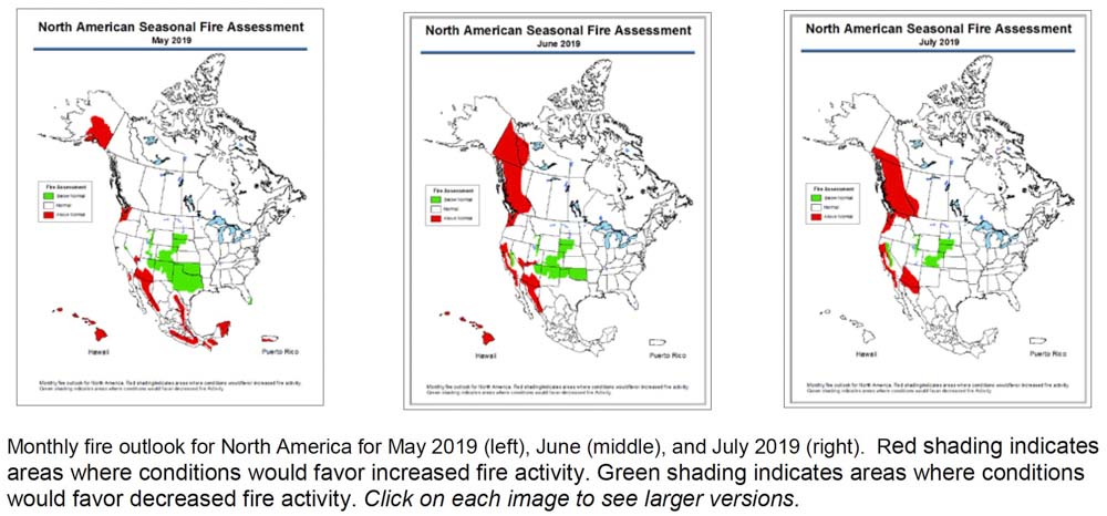
Wildfire potential for North America May, June, July, 2019
Wildfire potential for North America May, June, July, 2019. Click to enlarge.

The Predictive Services section at the National Interagency Fire Center has predicted above normal wildfire activity  this summer for southern Arizona, areas of California, and western Oregon and Washington.

An outlook for North America released on Friday also shows enhanced potential for British Columbia and the Yukon Territory in June and July.

Below is an excerpt from the North American Seasonal Fire Assessment and Outlook prepared by NIFC, Natural Resources Canada, and Servicio Meteorológico Nacional.

“For May, recent climate model runs suggest Canada will have lower fire severity than normal. While an early start to warm and dry conditions is leaving much of British Columbia prone to fire starts, rainfall is likely in the last half of the month, which will likely result in normal monthly fire severity for the province. The latest climate model runs hint at continued blocking ridges in the eastern Pacific during June, resulting in warm and dry conditions and resulting elevated fire severity indexes in British Columbia and Yukon. This pattern often features the eastern side of the ridge over the Prairies, so western Alberta also appears prone to elevated fire risk, while conditions east of Alberta are likely to have normal values. July’s forecast is similar to June’s forecast, with elevated fire severity indexes expected throughout British Columbia, western Alberta, and southern Yukon. A slight difference exists as the Yukon area depicted covers only the southern part of the territory in July, while in June it extended north near the Arctic coast.”

Wildfire potential for North America, May
Wildfire potential for North America, May 2019.
Wildfire potential for North America, June
Wildfire potential for North America, June 2019.
Wildfire potential for North America
Wildfire potential for North America, July 2019.

Wildfire potential, May through August

If NIFC’s analysis is correct, wildfire activity along the west coast will grow substantially into the summer

wildfire potential

On May 1 the Predictive Services section at the National Interagency Fire Center issued their Wildland Fire Potential Outlook for May through August. The data represents the cumulative forecasts of the ten Geographic Area Predictive Services Units and the National Predictive Services Unit.

If NIFC’s analysis is correct, the wildfire potential in areas along the west coast will grow substantially into the summer.

The multi-year drought in California has been virtually neutralized due to substantial quantities of winter rain and snow. An area to watch will be the west sides of Oregon and Washington.

Below:

  • An excerpt from the NIFC narrative report for the next several months;
  • More of NIFC’s monthly graphical outlooks;
  • NOAA’s three-month temperature and precipitation forecasts; and,
  • Drought Monitor.

“Greenup is occurring across the nation entering May; fuels across the Southwest are now drying and curing and will become increasingly receptive to fire activity as the month progresses. Looking north, Alaska’s interior is becoming drier and increasing activity is expected. By late May and early June, California and the southern Great Basin will see an increase in activity as fine fuels dry and cure. In July, low and middle elevation fine fuels will dry across the remainder of the West and will gradually become receptive to fire activity from south to north. Unlike most years, there could be a delayed start to the season in the higher, timbered elevations due to preexisting weather conditions and slower than average snowpack melting rates. An exception to this could be along the Canadian Border with Washington, Idaho, and western Montana where below average snowpack and moderate drought conditions exist. These areas can expect an average start to the season with a potential for above normal activity. A normal transition out of fire season is expected across Alaska in July. The onset of the southwestern monsoon may be slightly delayed.

“August marks the beginning of the peak of the western fire season. Most of the country can expect Normal conditions. Exceptions will be along the West Coast. A heavy crop of grasses and fine fuels has developed across California and should elevate the potential as it cures and dries. Higher elevations in the Sierra will likely see a late entry into the season due to the record-setting snowpack and slow meltoff. The Pacific Northwest has entered a period of moderate drought. An early entry is possible across the Cascades and in the Okanogan. Elsewhere, some high elevations across the Great Basin and central Rockies could experience Below Normal potential and conditions.”

wildfire potential

Continue reading “Wildfire potential, May through August”

Wildfire potential, April through July

The outlook predicts above normal potential for western Washington and northwest Oregon

April 2019

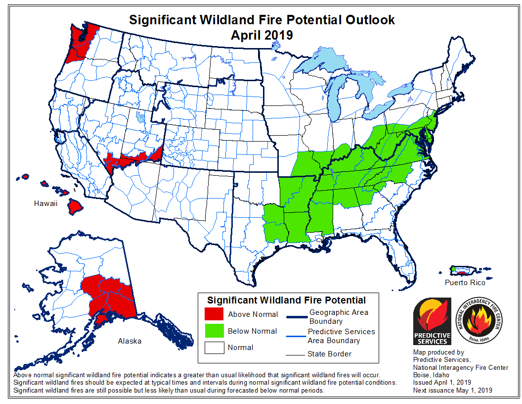
On April 1 the Predictive Services section at the National Interagency Fire Center issued their Wildland Fire Potential Outlook for April through July. The data represents the cumulative forecasts of the ten Geographic Area Predictive Services Units and the National Predictive Services Unit.

If NIFC’s analysis is correct, western Washington and northwest Oregon should see above normal wildfire activity through mid-summer. In June wildfire potential should pick up in the coastal mountains of California while most of the Sierra Nevada Mountains are expected to have below normal activity during those two months.

Below:

  • An excerpt from the NIFC narrative report for the next several months;
  • More of NIFC’s monthly graphical outlooks;
  • NOAA’s three-month temperature and precipitation forecasts; and,
  • Drought Monitor.

“As the spring greenup begins to take hold across the West in April, mountain snowpack will begin to melt. Snowpack melting rates are a more important factor than snowpack levels in assessing potential fire season activity ahead. An average or slower than average melting rate can allow for a late entry of the timbered elevations into the fire season, whereas a faster melting rate will allow for high elevation fuels to become receptive to fire sooner. In 2019, an average to cooler than average spring is expected, so melting rates should be near average which could result in a delayed fire season entry in areas that have abundant snowpack. An early entry is possible along the Canadian border in areas that have a below average snowpack. In the middle and lower elevations, abundant winter and spring moisture should translate to a heavy crop of fine fuels that will become increasingly receptive to fire activity across the West from south to north in May, June, and July.

“In Alaska, warmer than average temperatures should lead to an early snowpack loss and early entry into the fire season. A possibility exists that precipitation could become above average from June onward. This could lessen some of the state’s peak season fire potential during the second half of the season. After an active early start to the season, fire activity across the state should trend toward average conditions. Hawaii and Puerto Rico will continue to see slightly elevated potential early in the outlook period until the impacts of tropical weather conditions begin to be felt. The Southwestern fire season should begin to end in early July as a below average and perhaps late monsoon arrives.”

May 2019
Continue reading “Wildfire potential, April through July”

Wildfire potential, March through June

If NIFC’s analysis is correct, wildfire activity should begin to increase in Eastern New Mexico and Western Texas in April.

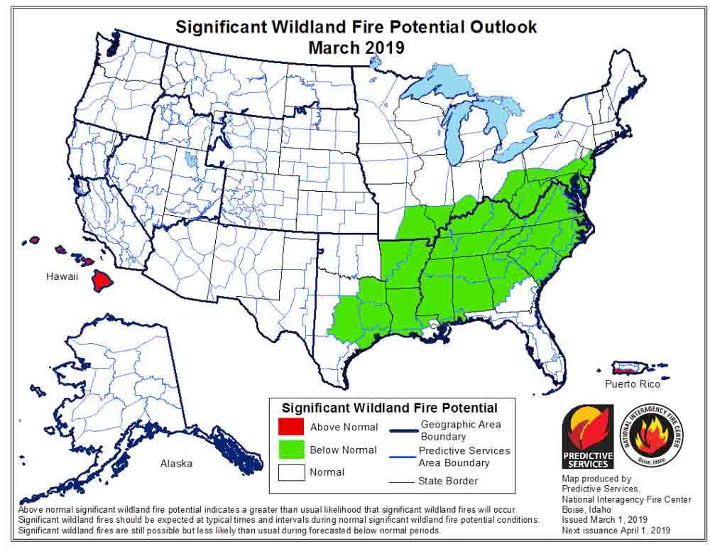
wildfire potential fire danger outlook forecastOn March 1 the Predictive Services section at the National Interagency Fire Center issued their Wildland Fire Potential Outlook for March through June. The data represents the cumulative forecasts of the ten Geographic Area Predictive Services Units and the National Predictive Services Unit.

If NIFC’s analysis is correct, in April wildfire activity should begin to increase in Eastern New Mexico and Western Texas. In May it will transition to the greater Grand Canyon area, with much of California added in June.

Below:

  • An excerpt from the NIFC narrative report for the next several months;
  • More of NIFC’s monthly graphical outlooks;
  • NOAA’s three-month temperature and precipitation forecasts; and,
  • Drought Monitor.

The majority of the nation remained out of fire season in February. The minimal fire activity observed continued to be well below average nation-wide. What was observed was minimal and limited mainly to the western fringes of the Southern Area. While a weak El Niño persisted, resulting weather conditions were atypical to what is often observed during such events. Precipitation was generally near to above average in most locations except for two regions. The central and southern Great Plains were especially dry, and the Deep South had pockets of dry conditions as well. Portions of West Texas and eastern New Mexico received less than 5% of average precipitation. Overall, the Deep South fared better but portions of the Carolinas and the lower Mississippi River Valley recorded below average precipitation.

Temperatures were generally within about 3 degrees of average across the country. A slight cold bias existed in the West and across the northern tier. A slight warm bias existed across the South and Texas. Extreme departures from average were observed across the northern Great Plains where temperatures were as much as 25 degrees below average.

The frequency and strength of Pacific weather systems moving on shore and across the West allowed for above average precipitation to reduce the severity and scope of the ongoing drought across California and portions of Oregon and the Great Basin. Incredible amounts of snowfall intermittently shut down travel across the High Sierra in California. Soil moisture levels improved across most areas except western Oregon where the persistent dry conditions continued.

March is a transition month. Pregreenup grassfire activity is not uncommon along and east of the Rocky Mountain Front. At least average activity is expected until green up takes hold. Concerns decrease west of the Continental Divide where sustained periods of wet and cold conditions have persisted the past few months. As greenup takes hold in April, most areas experiencing preseason activity should begin to see a decrease except for the Southwest where the drying of fuels begins to show a gradual westward migration of fire activity.

Fire activity in May and June should increase in coverage and intensity across the Southwest and California. Some slight expansion of activity into the southern Great Basin is also expected. The above average precipitation received during the late winter and early spring months could translate to another above average grass crop that could prove to be problematic in June.

wildfire potential fire danger outlook forecast

Continue reading “Wildfire potential, March through June”