Oklahoma: one person killed and six homes destroyed in wildfire

(UPDATED at 12:42 p.m. May 7, 2014)

The wildfire near Guthrie, Oklahoma burned approximately 3,250 acres. One
civilian fatality is attributed to this fire and an estimated 46 structures have been lost, according to Oklahoma Forestry Services (OFS). The fire has been turned back to local command with all containment lines holding through Tuesday’s weather conditions. OFS will have a Task Force with 3 dozers and 3 engines assisting with patrol and mop up on Wednesday.

****

(UPDATED at 11:57 a.m. CDT, May 6, 2014)

The wildfire near Guthrie, Oklahoma continued to be active on Monday due to strong winds and low relative humidity. The weather forecast for Tuesday is similar, predicting Red Flag conditions,  with 94 degrees, 23 percent relative humidity, and 24 mph winds gusting up to 33 mph. Tuesday morning the fire was reported to be 90 percent contained.

In the video below, Guthrie Fire Department Chief Eric Harlow provides an update on the fire. It was recorded May 5, probably late in the day, and was uploaded to YouTube on May 6. 

Despite earlier reports provided by fire officials, investigators with the Oklahoma state Department of Agriculture and the state Fire Marshall’s Office have found no evidence the fire started as a controlled burn.

****

(UPDATED at 7:15 p.m. CT, May 5, 2014)
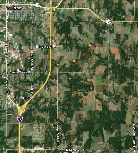
Map of fire near Guthrie, OK 250 pm CT May 5, 2014
Map of fire near Guthrie, OK, showing the approximate locations of heat detected by a satellite at 2:50 p.m. CT, May 5, 2014. The red and yellow dots represent the location of the heat.

The location of the fire is southeast of Guthrie, Oklahoma, 24 miles north of Oklahoma City, and east of Interstate 35 (map).

The local fire departments have not released information about the exact location of the origin of the fire, but they did say it started from a “controlled burn” — which could mean anything from a resident burning trash in their back yard, to a rancher burning a pasture. Google Earth did not show any indication that any federal land was in the area of the fire.

Fox23 in a Monday afternoon report said at least a dozen homes have burned and the estimated size of the fire is now 3,000 to 3,500 acres. National Guard Blackhawk helicopters worked the fire Monday.

From Fox23:

Gov. Mary Fallin visited the command post Monday, and said the US Forestry Services crews were creating fire lines and that she put in a request to get an air tanker flown to Guthrie from Arizona.

According to the Oklahoma Department of Emergency Management three National Guard Blackhawk helicopters, two single engine air tankers (SEATs), and “a Tanker 415” will be available Tuesday evening. The “Tanker 415” could be Tanker 260, Aero-Flite’s CL-415 that was reported by Wildfire Today reader Tom Wilson (in a comment below) to be relocating from Florida to Oklahoma City on Monday. Fire Aviation had an article about Tanker 260 in November.

According to state law the Oklahoma Division of Forestry is the operational lead for wildfire emergencies.

The video below, uploaded to YouTube about 3 p.m. on Monday, has views of the fire from an aircraft.


****

(Originally published at 11:52 a.m. CT, May 5, 2015)

Fire officials said a controlled burn near Guthrie, Oklahoma escaped on Sunday and killed one person and destroyed at least six homes. Guthrie Fire Department Chief Eric Harlow said the number of damaged homes was expected to rise after they are able to better assess the four to six square mile (2,560 to 3,840 acre) fire after sunrise on Monday. About 1,000 people evacuated on Sunday, but most of those have been able to return to their homes.

Chief Harlow said the 56-year old man who was killed had refused to evacuate when requested by his family and law enforcement.

On Sunday the fire was pushed by strong winds and dry conditions. The weather forecast for the Guthrie area on Monday calls for similar weather — 100 degrees, 17 to 20 mph southeast winds gusting to 28 mph, and single-digit relative humidities.

Early Monday morning Chief Harlow said:

We still have some hot spots but for the most part we do have control of this thing. I’m still going to say 75 percent containment. Three of the four sides are contained. The north side I’m not going to say is 100 percent contained yet.

He said the fire started from a controlled burn on one of two properties, but did not know exactly what the land owner had initially intended to burn.

They have requested helicopters from the National  Guard which would arrive at 11 a.m. at the earliest.

The video below is a recording of a live media briefing early Monday morning featuring Chief Harlow.

Florida: prescribed fire escapes at St. Johns National Wildlife Refuge

Saint Johns National Wildlife Refuge, map

A prescribed fire escaped at a national wildlife refuge east of Orlando on Monday. The plan was to burn 660 acres within St. Johns National Wildlife Refuge, but multiple simultaneous spot fires outside the burn unit exceeded the capability of the firefighters from Merritt Island National Wildlife Refuge who were conducting the burn. An additional 72 acres of private land and 200 acres of Brevard County property outside the refuge burned — 600 acres in the original planned unit were completed.

The escape was knocked down by 43 personnel on Monday. Today spokesperson Candice Stevenson of the U.S. Fish and Wildlife Service said the fire is 70 percent contained. Agencies involved in the suppression of the escaped fire included the U.S. Fish and Wildlife Service, Brevard County, Florida Forest Service, the City of Titusville, and the U.S. Forest Service.


Custer State Park burns 560 acres

South Fork Prescribed Fire
Ignition begins at the South Fork Prescribed Fire, April 25, 2014. Photo by Andrew Tate.

Custer State Park, in the Black Hills of South Dakota, completed a 560-acre prescribed fire Friday afternoon near the buffalo corrals. The objective of the project was to improve grass habitat for buffalo and other wildlife and to enhance interagency cooperation and training for firefighters. Other agencies that assisted were South Dakota Wildland Fire, South Dakota Game, Fish and Parks, the National Park Service, and the Black Hills National Forest.  

I arrived at the scene at about 1:30 p.m. thinking that the most active fire activity would be in mid-afternoon, but they were just finishing the ignition as I pulled up. With good planning, an early start, and with roads on some sides for firelines, a 560-acre prescribed fire in grass does not take all day.

South Fork Prescribed Fire. Photo by Andrew Tate.

The photos below were taken by Bill Gabbert for Wildfire Today and are protected by copyright.
Continue reading “Custer State Park burns 560 acres”

Iowa prescribed fire escapes, burns private property

Burned property in Iowa
Glen Dale Geiger examines his property that burned during an escaped prescribed fire in Iowa. Photo from KCRG.

A prescribed fire conducted by the Iowa Department of Natural Resources escaped on April 12 and burned onto three nearby properties. One of the victims was Glen Dale Geiger who lost three structures containing farm equipment and his pride and joy, a 1960 convertible that burned exactly 54 years to the day after he bought it. Mr. Geiger said other equipment lost included, “My corn picker, corn planter, my baler, feed wagons, my other wagon sitting outside, my camper in the corn crib, snow blower, bicycles,”

At first the DNR said the National Weather Service gave them “the wrong forecast”, but they later backtracked from that, saying the DNR did not follow protocol in checking the weather for the site of the prescribed fire.
Thanks and a hat tip go out to Chip.

The cost of prescribed fire in Oklahoma

Black lining on the Dillon Prescribed fire
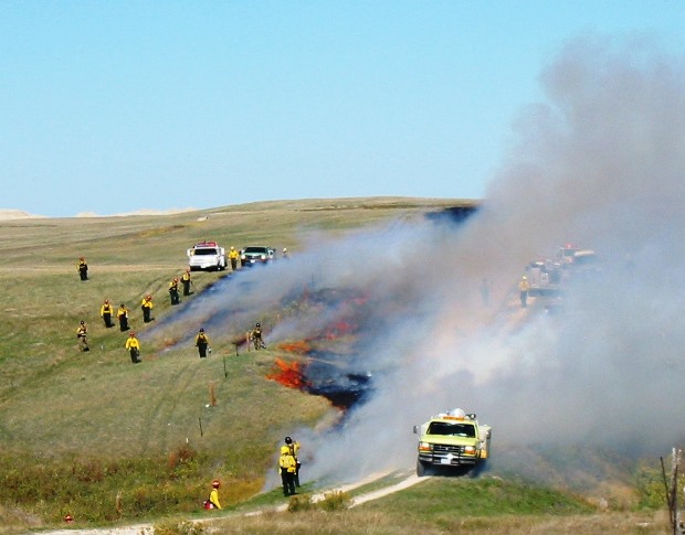
Black lining on the Dillon Prescribed fire at Badlands National Park in South Dakota, October 10, 2002. NPS photo by Bill Gabbert.

The Noble Foundation kept track of the costs of conducting prescribed fires in 1996 on the Noble Foundation D. Joyce Coffey Resource and Demonstration Ranch west of Marietta, Oklahoma. A report they prepared also took into account the costs of burning on properties belonging to Terry Stuart Forst, a Noble Foundation cooperator. The lands have a variety of topographical features and plant communities from which to evaluate the costs and effects of prescribed fires.

The costs per acre listed below are from activities in 1996, so an adjustment will have to be made to consider them in current day dollars. According to The Inflation Calculator, the difference between 1996 dollars and 2013 costs is plus 46 to 67 percent.

  • Timber, Coffey Ranch: $4.64/acre
  • Grassland, Stuart Ranch: $0.23/acre
  • Timber/grassland, Stuart Ranch: $0.35/acre

Prescribed fire as a hands-on tourist attraction

Flint Hills Rx
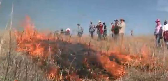
Prescribed fire ignited by tourists at the Flying W Ranch in Kansas. Screen shot from the video below.

A cattle ranch in the tall grass prairie of Kansas allows tourists to observe and if they want, to help ignite prescribed fires on their property. The Flying W Ranch in the Flint Hills supplements their income by charging ranch visitors $100 to help start the fires by dropping wooden matches in the grass. We counted approximately 30 tourists in one of the scenes in the video below. The admission fee also includes a steak dinner. Their next hands-on prescribed fire is scheduled for April 5.

We can think of a lot of positives about an activity like this. Many ranchers could use an additional $3,000 (before expenses) to supplement their income.  It could also provide an opportunity to educate the public about the benefits of prescribed fire, and how the process is essential for managing tall grass prairies and other vegetation types. In my experience as a Fire Management Officer, I learned that if you have a high-ranking manager in your organization that knows little about fire management, invite them to observe a prescribed fire. Loan them some personal protective equipment (PPE), and while under close supervision, let them operate a drip torch for five minutes. They will be hooked. (After seeing this video, a couple of matches could suffice.)

The negatives of a public hands-on prescribed fire are pretty obvious and revolve around the liability of the ranch owner and the safety of the participants who have no PPE or training, other than a briefing before the event. If there is an unexpected wind shift on a grass fire, experienced firefighters wearing PPE know that often they can find a place where they can step through the flames into a previously burned black area. Who knows what tourists, including children, might do.  It is hard to believe that an insurance company would issue a liability policy to cover an event like this.

Thanks and a hat tip go out to Tristan