Red Flag Warnings, November 18, 2015

wildfire Red Flag Warnings 11-18-2015

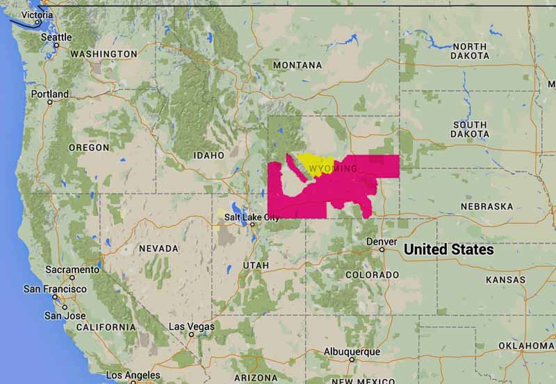
The Red Flag Warning map is interesting today, with the only warning area being in the southwest corner of North Dakota, in effect from late Wednesday morning through early evening. It is another example of weather conditions, as reported by the National Weather Service, being affected by state boundaries.

Black Hills wind forecast
Greater Black Hills wind forecast November 18, 2015. Parts of SD, WY, MT, ND, & NE.

Here is the weather forecast for the center of the Red Flag Area in North Dakota; what it does not include is the relative humidity, which is predicted to be 35 to 45 percent:

A chance of rain and snow showers before 2pm, then a chance of snow showers between 2pm and 4pm. Mostly cloudy, then gradually becoming sunny, with a temperature falling to around 28 by 5pm. Windy, with a northwest wind 26 to 31 mph increasing to 40 to 45 mph in the afternoon. Winds could gust as high as 65 mph. Chance of precipitation is 40%. Total daytime snow accumulation of less than a half inch possible.

And below, the forecast for northwest Wyoming (RH 35 percent):

A slight chance of rain showers, mixing with snow after 2pm, then gradually ending. Partly sunny, with a temperature falling to around 31 by 5pm. Very windy, with a northwest wind 29 to 34 mph increasing to 39 to 44 mph in the morning. Winds could gust as high as 60 mph. Chance of precipitation is 20%.

And northwest South Dakota (RH 33 percent):

Isolated showers before 9am. Partly sunny, with a temperature falling to around 32 by 5pm. Very windy, with a northwest wind 28 to 38 mph increasing to 39 to 49 mph in the morning. Winds could gust as high as 70 mph. Chance of precipitation is 20%.

As you can see in the map below, the peak wind gusts recorded at around 8 a.m. MST on Wednesday were in the 40s and 50s in western Montana and northwest South Dakota. Much of western Wyoming was in the same boat. There was a 71 mph gust at Cheyenne, Wyoming.

The high wind speeds are caused by a strong cold front moving through the area, which may not have reached full strength in North Dakota at 8 a.m.

Peak wind gusts 8 am MST 11-18-2015
Peak wind gusts at 8 a.m. MST, November 18, 2015.

Apparently the NWS weather forecasters in these areas disagreed about how to evaluate the very strong winds balanced with the chance of precipitation, and then how to decide if conditions met the Red Flag criteria.

We have gotten the impression over the years that there is a lot of subjectivity that goes into Red Flag Warnings. The criteria for determining the Warnings is supposed to be very cut and dried and objective, and varies from area to area based on historical weather and fuels. But it is not uncommon to see the boundaries for Red Flag Warnings end at state lines even though conditions and forecasts may be very similar on both sides of those imaginary lines.

The Red Flag map was current as of 8:00 a.m. MDT on Wednesday. Red Flag Warnings can change throughout the day as the National Weather Service offices around the country update and revise their forecasts and maps. For the most current data visit this NWS site or this NWS site.

Red Flag Warnings, October 19, 2015

wildfire Red Flag Warnings 10-19-2015

The National Weather Service has issued Red Flag Warnings or Fire Weather Watches for areas in Nebraska, Kansas, Iowa, Illinois, Missouri, Indiana, Arkansas, and California.

The map was current as of 8 a.m. MDT on Monday. Red Flag Warnings can change throughout the day as the National Weather Service offices around the country update and revise their forecasts and maps. For the most current data visit this NWS site or this NWS site.

Red Flag Warnings, October 2, 2015

wildfire Red Flag map 10-2-2015

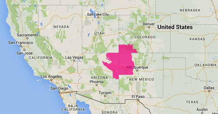
The National Weather Service has issued Red Flag Warnings for areas in Arizona, New Mexico, and Colorado.

The map was current as of 9 a.m. MDT on Friday. Red Flag Warnings can change throughout the day as the National Weather Service offices around the country update and revise their forecasts and maps. For the most current data visit this NWS site or this NWS site.

Smoke map and Red Flag Warnings, September 13, 2015

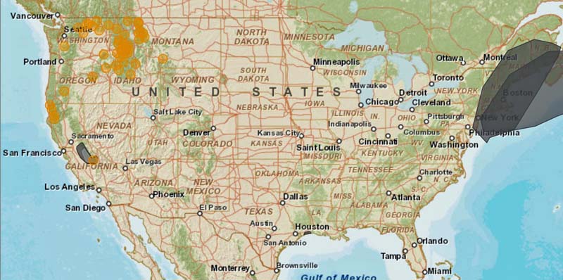
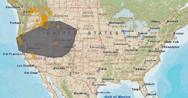
Smoke map 9-13-2105
Smoke, primarily from the Valley Fire and River Complex Fires in California, spreads over much of the west, September 13, 2015. The round brown icons represent the locations of large fires. AirNow.

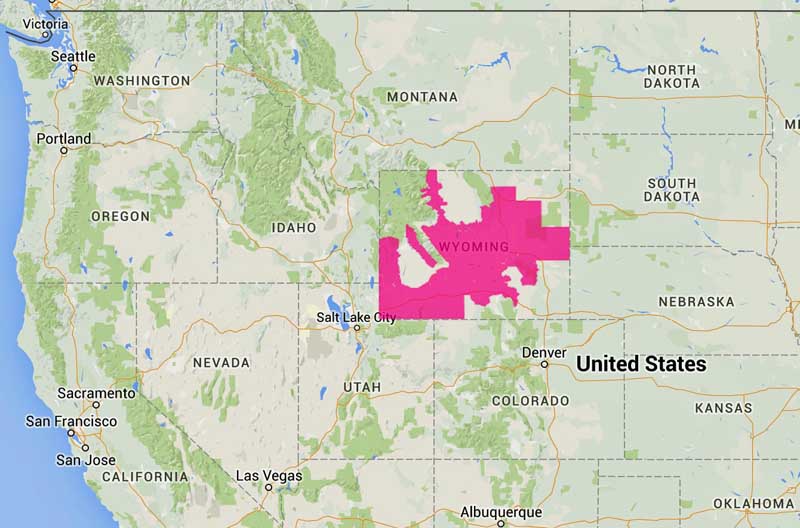
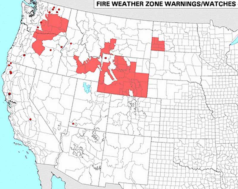
The National Weather Service has issued Red Flag Warnings or Fire Weather Watches for areas in Wyoming, North Dakota, Idaho, Montana, Washington, and Oregon.

Red Flag Warnings, 9-13-2105

The Red Flag map was current as of 11 a.m. MDT on Sunday. Red Flag Warnings can change throughout the day as the National Weather Service offices around the country update and revise their forecasts and maps. For the most current data visit this NWS site or this NWS site.
To see the most current smoke reports on Wildfire Today, visit the articles tagged “smoke” at https://wildfiretoday.com/tag/smoke/

Smoke map and Red Flag Warnings

wildfire smoke map
Wildfire smoke map, morning of September 7, 2015. The round brown icons represent the locations of large fires.

The National Weather Service has issued Red Flag Warnings or Fire Weather Watches for areas Wyoming.

Again today, the weather and vegetation are cooperating and confining their extreme conditions within state borders, simplifying the job of fire meteorologists.

wildfire red flag warnings
Red Flag Warnings, September 7, 2015

The Red Flag map was current as of 10:30 a.m. MDT on Monday. Red Flag Warnings can change throughout the day as the National Weather Service offices around the country update and revise their forecasts and maps. For the most current data visit this NWS site or this NWS site.
To see the most current smoke reports on Wildfire Today, visit the articles tagged “smoke” at https://wildfiretoday.com/tag/smoke/

Smoke map and Red Flag Warnings, September 6, 2015

(Originally published at 9:13 a.m. MT, Sept. 6, 2015; updated with revised smoke map at noon, MT, Sept. 6, 2015)

Smoke map, Sept. 6, 2015
Smoke map, Sept. 6, 2015. AirNow. The round brown icons represent the locations of wildfires.

The National Weather Service has issued Red Flag Warnings or Fire Weather Watches for areas Wyoming.

Again today, the weather and vegetation are cooperating and confining their extreme conditions within state borders, simplifying the job of fire meteorologists.

Red Flag Warnings 9-6-2015
Red Flag Warnings 9-6-2015.

The Red Flag map was current as of 9 a.m. MDT on Sunday. Red Flag Warnings can change throughout the day as the National Weather Service offices around the country update and revise their forecasts and maps. For the most current data visit this NWS site or this NWS site.
To see the most current smoke reports on Wildfire Today, visit the articles tagged “smoke” at https://wildfiretoday.com/tag/smoke/