Wildfire briefing, March 24, 2014

Research: global wildfires did not kill the dinosaurs

Contrary to what other researchers concluded, a new study revealed that an asteroid that hit the Earth 65 million years ago on the Yucatan Peninsula in Mexico did not cause global wildfires that wiped out the dinosaurs. The first study led scientists to think that the impact raised temperatures to 1,000 degrees C, igniting global wildfires that killed most organisms.

The latest research team from Royal Holloway, University of London, led by Claire Belcher, concluded that “…the amounts of thermal radiation released by the impact of an asteroid with the Earth 65 million years ago, were not as significant as previously thought, and the energy component of the K-T event was not responsible for the extinctions seen at this time”.

Research: Understanding evacuation preferences and wildfire mitigations among Northwest Montana residents

The paper with the above title, written by Travis Paveglio, Tony Prato, Douglas Dalenberg, and Tyron Venn, employees who work at state Universities in Idaho, Missouri, and Montana, is available for taxpayers to read if they pay $25 to an organization in Australia.

Public Service Announcements about wildfire

An organization in Nevada has produced and released nine 31-second public service announcements about wildfire evacuation and defensible space. The list is HERE, and below is an example:

Colorado state Senator has second thoughts about bill that would have limited agricultural burning

A Colorado state Senator who introduced a bill that would allow county commissioners to ban agricultural burning and campfires when fire danger is high has had second thoughts and now wants to pull the bill. Senator Larry Crowder from Alamosa, under pressure from farmers, said Friday that there could be a possibility of county officials over using the power. The bill already passed the House by a 36 to 27 vote on February 14.

A tweet from Smokey Bear

Tweets about a fire in Capetown, South Africa

(Hopefully the photos will appear below. Sometimes they do, and sometimes they don’t.)

Throwback Thursday

Today at Wildfire Today we’re looking six years back, at what we were writing about March 16-22, 2008.

Oklahoma State Trooper burned in grass fire. Trooper Josh Tinsler, 23, was severely burned while checking to see if there was anyone at home in a house that was threatened by a grass fire near Hollis, OK.

Update on study about large fires and greenhouse gases

Brush fire at Monkey Junction

The sweet smell of smoke. That was the headline above an editorial in the Payson Roundup in Arizona. They were “giddy” about the Forest Service reducing fuels and burning piles.

Lawsuit against Mark Rey and the USFS dismissed. A lawsuit that forced the nation’s top forestry official to apologize in a Missoula courtroom was over.

Video about 2003 fire tornado in Australia, and the results of the fire behavior research

Lee side slope fire behavior
Lee side slope fire behavior. A wind eddy on the lee slope can push the fire up the slope opposite the prevailing wind direction. At the ridge top, the fire can also move horizontally, 90 degrees off the main wind direction. Screen grab from the video.

In November, 2012 we wrote about some of the research that was conducted to study and document what can only be described as a fire tornado in Australia, a tornado-like event that can be generated by a wildfire. In recent years a new term has been coined — firenado — which seems appropriate.

It occurred near Chapman in the Australian Capitol Territories during the McIntyres Hut Fire January 18, 2003. After studying the event, Rick McRae of the ACT and others discovered that it traveled across 25 kilometers at 30 kph (19 mph), had horizontal winds of 250 kph (149 mph), and vertical winds of 150 kph (93 mph). Damage that occurred to trees and structures is much like what you would see after a tornado in Oklahoma.

Australia’s ABC TV produced an excellent video that goes surprisingly deeply into some of the scientific principles of this phenomenon, including fire behavior when a strong wind pushes a fire up a slope. This can result in spot fires at the bottom of the slope on the other side, the lee slope, which can be pushed rapidly up the lee slope by a wind eddy in the opposite direction of the prevailing wind (see the screen grab above from the video). They also documented how a fire at the top of the ridge can travel across the ridge at 90 degrees to the direction of the prevailing wind.

Knowledge about this kind of fire behavior is something that wildland firefighters should retain in their “slide file”, in the unfortunate event that they find themselves in danger of being entrapped and are considering using the lee side of a ridge as an escape route or a sheltering location.

Check out our November, 2012 article for more information about this 2003 event. The video below illustrates some of the findings developed by the fire researchers.

The information in the video can be even more interesting when considered along with the winds at the site of the Yarnell Hill Fire entrapment, as modeled by WindWizard. The image below is from page 79 of the Yarnell Hill Fire SAIT report. Click the image to see a slightly larger version.

Yarnell Hill Fire, wind vectors modeled using WindWizard

A “Climate Change and Wildfire” research paper that you can’t read

Federal employees working for the United States Forest Service and the citizens of the United States have published the results of research done on behalf of the taxpayers, titled Climate Change and Wildfire. If you want to read it you will have to pay $35.95 to the for-profit Elsevier corporation headquartered in the Netherlands that published the paper. It was written by research meteorologists Yongqiang Liu and Scott Goodrick from the Forest Service’s Southern Research Station (SRS) and Warren Heilman from the Northern Research Station. The concept of Open Access to taxpayer-funded research still has a long way to go in the U.S. Forest Service.

Below are some highlights of the research, according to the USDA Forest Service’s Southern Research Station. We will have to take their word for it. The agency suggests that “for the full text of the article” go to the Elsevier web site, where you have to pay $35.95.

****

(UPDATE at 11:44 a.m. MST, February 24, 2014)

After we reached out to her and left a message, we received a phone call today from Zoë Hoyle, the author of the press release about the research that was issued May 20, 2013. She said the link to the full text of the article which directed web site visitors to the pay wall was an error. She said the usual practice of USFS researchers is to place their results on http://www.treesearch.fs.fed.us/ where they can be read at no charge, but that still has not taken place. Ms. Hoyle said, however, that the paper should be on treesearch by the end of this week.

In the meantime, one of our readers, Liz H., used Google Scholar to find a copy of it at firescience.gov. Thanks Liz.

And thanks go out also to Ms. Hoyle for correcting the oversight. We are pleased to hear that the usual practice of the USFS is to publish their research on treesearch, an open access format on the internet.

****

(UPDATE at 1:54 p.m. MST, February 24, 2014)

Ms. Hoyle contacted us again to let us know that the USFS was able to expedite the placement of the research paper on treesearch, where it can now be viewed without having to pay the company from the Netherlands $35.95.

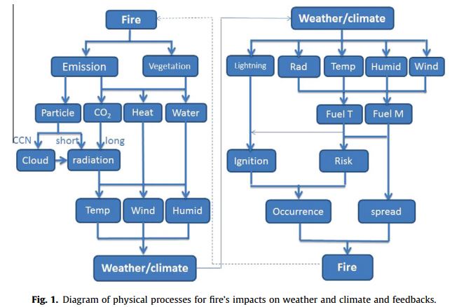
Here is one of the illustrations from the paper, about the interactions between the climate and fire.

Wildfire-climate interactions

Below is an excerpt from the May 20, 2013 USFS news release about the research.

****

“While research has historically focused on fire-weather interactions, there is increasing attention paid to fire-climate interactions,” says Liu, lead author and team leader with the SRS Center for Forest Disturbance Science. “Weather, the day-to-day state of the atmosphere in a region, influences individual fires within a fire season. In contrast, when we talk about fire climate, we’re looking at the statistics of weather over a certain period. Fire climate sets atmospheric conditions for fire activity in longer time frames and larger geographic scales.”

Wildfires impact atmospheric conditions through emissions of gases, particles, water, and heat. Some of the article focuses on radiative forcing from fire emissions. Radiative forcing refers to the change in net (down minus up) irradiance (solar plus longwave) at the tropopause, the top of the troposphere where most weather takes place.

Smoke particles can generate radiative forcing mainly through scattering and absorbing solar radiation (direct radiative forcing), and modifying the cloud droplet concentrations and lifetime, and hence the cloud radiative properties (indirect radiative forcing). The change in radiation can cause further changes in global temperatures and precipitation.

“Wildfire emissions can have remarkable impacts on radiative forcing,” says Liu.

“During fire events or burning seasons, smoke particles reduce overall solar radiation absorbed by the atmosphere at local and regional levels. At the global scale, fire emissions of carbon dioxide contribute substantially to the global greenhouse effect.”

Other major findings covered in the synthesis include:

  • The radiative forcing of smoke particles can generate significant regional climate effects, leading to lower temperatures at the ground surface.
  • Smoke particles mostly suppress cloud formation and precipitation. Fire events could lead to more droughts.
  • Black carbon, essentially the fine particles of carbon that color smoke, plays different roles in affecting climate. In the middle and lower atmosphere, its presence could lead to a more stable atmosphere. Black carbon plays a special role in the snow-climate feedback loop, accelerating snow melting.

Land surface changes may be triggered that also play into future effects. “Wildfire is a disturbance of ecosystems,” says Liu. “Besides the atmospheric impacts, wildfires also modify terrestrial ecosystem services such as carbon sequestration, soil fertility, grazing value, biodiversity, and tourism. The effects can in turn trigger land use changes that in turn affect the atmosphere.”

The article concludes by outlining issues that lead to uncertainties in understanding fire-climate interactions and the future research needed to address them.

Full text of the article: [note from Bill. We deleted the link to the for-profit web site with the pay wall]

Research: air pollution can increase wildfire risk

A National Park Service study suggests air pollution in the Santa Monica Mountains is harming native plants, increasing the fire risk.

****

THOUSAND OAKS, Calif. – Initial results from experiments conducted in the Santa Monica Mountains indicate that high levels of nitrogen may adversely impact native plants and, by extension, increase the risk of wildfire.

air pollution effect on wildfire
Interns measure plots of California sagebrush that have been injected with various levels of nitrogen as part of a three-year study to learn how air pollution is impacting native plants and fire risk. National Park Service photo.

“No one will be surprised to learn that our data shows increased air pollution on the eastern end of the mountains, closer to Los Angeles,” said Dr. Irina Irvine, restoration ecologist for Santa Monica Mountains National Recreation Area. “What’s more intriguing about this study is learning how high nitrogen levels affect native vegetation and what that might mean for fire risk in such a fire-prone region.”

The preliminary results are from the first year of a three-year study undertaken by Irvine, UC Riverside’s Dr. Edith B. Allen and the U.S. Forest Service’s Dr. Andrzej Bytnerowicz and Dr. Mark Fenn.

Researchers measured atmospheric nitrogen deposition levels at 10 sites throughout the Santa Monica Mountains and found significantly higher pollution levels in the eastern end (see map). At the two sites with the best air quality, they added various levels of nitrogen into experimental plots of coastal sage scrub to simulate pollution levels found throughout the mountains.

Higher levels of nitrogen led to a decline in native shrub seedlings and an increase in nonnative grasses. Other studies in Australia and California have demonstrated a link between nonnative grasses, also known as “flashy fuels,” and larger and more frequent wildfires.

Funded by the National Park Service’s Air Resources Division, the $100,000 study will help scientists better determine the “critical load” when vegetation shifts, causing alterations to the structure and functionality of ecosystems. Coastal sage scrub once covered much of coastal California and is now an endangered habitat type, primarily due to development.

Generally attributed to vehicle emissions in the Santa Monica Mountains, nitrogen deposition is the air pollution from industry, agriculture and transportation that settles out of the atmosphere and onto the earth’s surface.