Briefing on the largest California fires

August 22, 2020 | 7:36 p.m. PDT
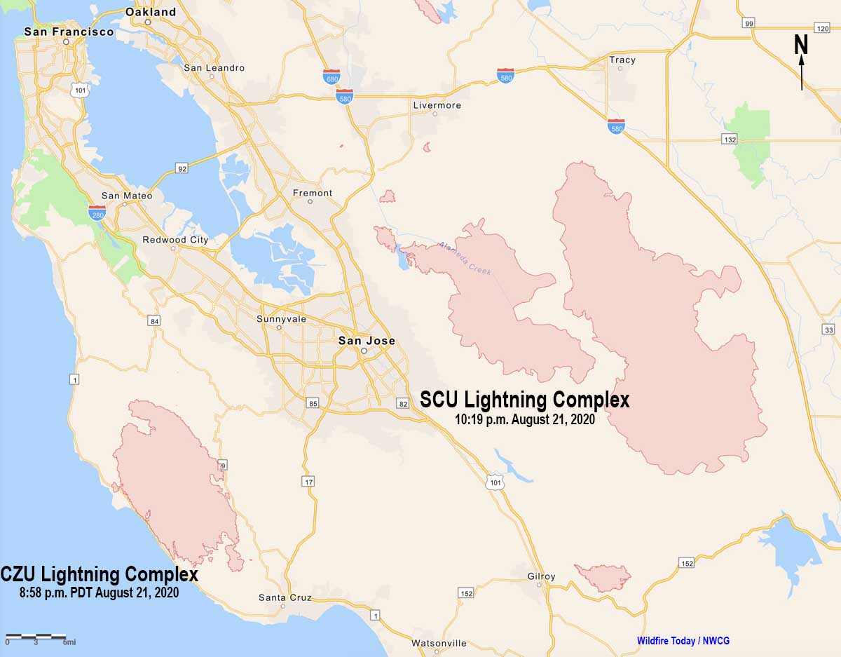
Map SCU Lightning Complex and CZU August Lightning Complex of fires
Map of the SCU Lightning Complex and CZU August Lightning Complex of fires August 21, 2020.

Saturday, on the seventh day after a 72-hour lightning bust started hundreds of wildfires in California, firefighters are stretched thin attempting to suppress the blazes and protect residents and property. Shortages of personnel, fire apparatus, and aircraft are showing up statewide.

(To see all of the articles on Wildfire Today about the lightning-caused wildfires in California, including the most recent, click HERE.)

Nearly 12,000 firefighters are battling over 20 major fires and complexes of fires in California, most of which were started by about 12,000 lightning strikes. There have been 560 new fires in the last week, primarily a result of the lightning. Firefighters contained a large majority of the blazes, but in spite of their best efforts, over 771,000 acres had burned through Friday prompting evacuations of 175,000 residents. About 96 percent of CAL FIRE’s engines are committed throughout the state. The fires have killed at least five people and injured 33.

Governor Gavin Newsom said in a news conference Friday that he has requested the assistance of Australian and Canadian firefighters.

We’ve also reached out across the border into Canada for resources and support. And many of you up here recall, I think it was 2017, the support that we were provided and the support we provided in turn of some of the best wildfire firefighters in the world from Australia. We also have requests out for that talent as well.

The ability for the U.S. to send firefighters to assist Australia and New Zealand is authorized in a formal agreement under the Emergency Wildfire Suppression Act. Last winter the U.S. sent over 150 firefighters to assist with bushfires in Australia, and has been the recipient of assistance from down under on several occasions.

The Monterey Herald reported that due to the River and Carmel Fires prospective visitors to Monterey County have been asked to delay their travel plans. A joint statement released from U.S. Rep. Jimmy Panetta and four local politicians said, “We also ask anyone considering travel to Monterey County to delay your travel plans. This will ensure that already limited local resources are not strained.”

LNU Lightning Complex

  • Updated August 22, 2020 at 7:24 p.m. PDT, Aug. 22
  • Location: North Bay
  • Counties: Napa, Lake, Yolo, Solano, Sonoma
  • Administrative Unit: CAL FIRE Sonoma-Lake-Napa
  • Acres: 314,207. The largest fire in the complex is the Hennessey Fire, 261,793. The Walbridge Fire west of Healdsburg is 50,069, and the Meyers Fire on the coast north of Jenner is 2,345.
  • Structures destroyed: 560
  • Personnel assigned: 1,429
  • Evacuation information:  CAL FIRE LNU Twitter page
  • Notes: Significant fire growth is expected Saturday. Extreme fire behavior with short and long range spotting are continuing to challenge firefighting efforts. Fires that merged to become the Hennessey Fire include Gamble, Green, Spanish, 5-10, Morgan, and Markley Fires.
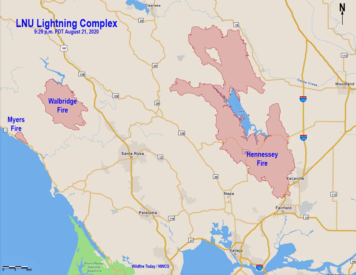
Map of the LNU Lightning Complex fires
Map of the LNU Lightning Complex of fires at 9:26 p.m. PDT August 21, 2020.

SCU Lightning Complex

  • Updated August 22, 2020 at 7:25 p.m. PDT, Aug. 22
  • Location: South Bay
  • Counties: Santa Clara, Alameda, Stanislaus, Contra Costa, San Joaquin
  • Administrative Unit: CAL FIRE Santa Clara
  • Acres: 291,968
  • Structures destroyed: 5
  • Personnel assigned: 1,179
  • Evacuation information:  CAL FIRE SCU Twitter page
  • Notes:  Fire activity is expected to increase Saturday when the inversion lifts and smoke clears. The complex is comprised of approximately 20 separate fires broken into three zones; the Canyon Zone, the Calaveras Zone, and the Deer Zone.

CZU August Lightning

  • Updated August 22, 2020 at 7:27 p.m. PDT, Aug. 22
  • Location: South Bay
  • Counties: San Mateo, Santa Cruz
  • Administrative Unit: CAL FIRE San Mateo-Santa Cruz
  • Acres: 63,000
  • Structures destroyed: 97
  • Personnel assigned: 1,157
  • Evacuation information: CAL FIRE CZU Twitter page
  • Notes: Continued hot and dry weather is predicted for the remainder of the weekend and into next week. Damage Inspection Teams have begun to survey areas where fire activity has diminished and it safe to do so. Firefighting resources are limited due to the number of fires burning throughout California. Visibility reduced due to smoke has been hampering aircraft operations. Approximately 77,000 people have been evacuated.

River, Carmel, and Dolan Fires

The Carmel Fire 2 miles southwest of the River Fire has burned 6,695 acres.

The Dolan Fire on the coast 10 miles south of Big Sur has spread to 8,500 acres on private land and the Los Padres National Forest.
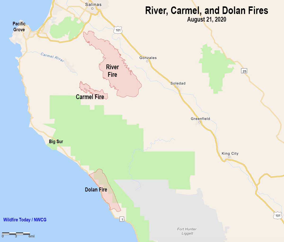
River Carmel Dolan Fires map August 21 California
Map showing the locations of the River, Carmel, and Dolan Fires August 21, 2020.

August Complex

  • Updated August 22, 2020 at 7:34 p.m. PDT, Aug. 22
  • Location: 18 miles southwest of Red Bluff
  • Counties: Tehama, Glenn, Lake, Mendocino, Trinity
  • Administrative Unit: Mendocino National Forest and CAL FIRE
  • Acres: 160,005
  • Structures destroyed: 10
  • Personnel assigned: 357
  • Evacuation information:
  • Notes: The Complex, comprised of 20 fires, grew by over 31,000 acres August 21. The two largest in the Complex are the Doe (120,875 acres) and Glade (86,028 acres). A Structure Damage Assessment Team has been ordered. Firefighters in a remote location were resupplied with a four-day supply of food via four motorized GPS-guided parachutes which descended through smoke.
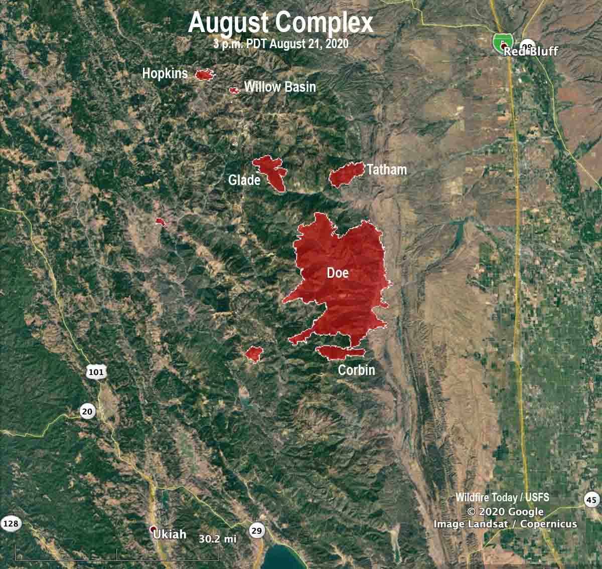
August Complex of fires map California
August Complex of fires map, 3 p.m. PDT August 21, 2020.

River Fire prompts evacuations south of Salinas, California

August 17, 2020  |  6:22 p.m. PDT

Map River Fire at 2:28 p.m. PDT August 17, 2020
Map of the River Fire at 2:28 p.m. PDT August 17, 2020.

Not much additional information is available about the River Fire. Monterey County has current evacuation information. CAL FiRE has not updated the size since they announced it was 2,800 acres this morning.

(To see all of the articles on Wildfire Today about the lightning-caused wildfires in California, including the most recent, click HERE.)

Five structures have been damaged and there have been four “Confirmed Fire Personnel and Civilian Injuries” according to CAL FIRE.

Resources assigned include 10 hand crews, 2 helicopters, 55 fire engines, 9 dozers, and 6 water tenders for a total of 520 personnel.


August 17, 2020  |  7:13 a.m. PDT

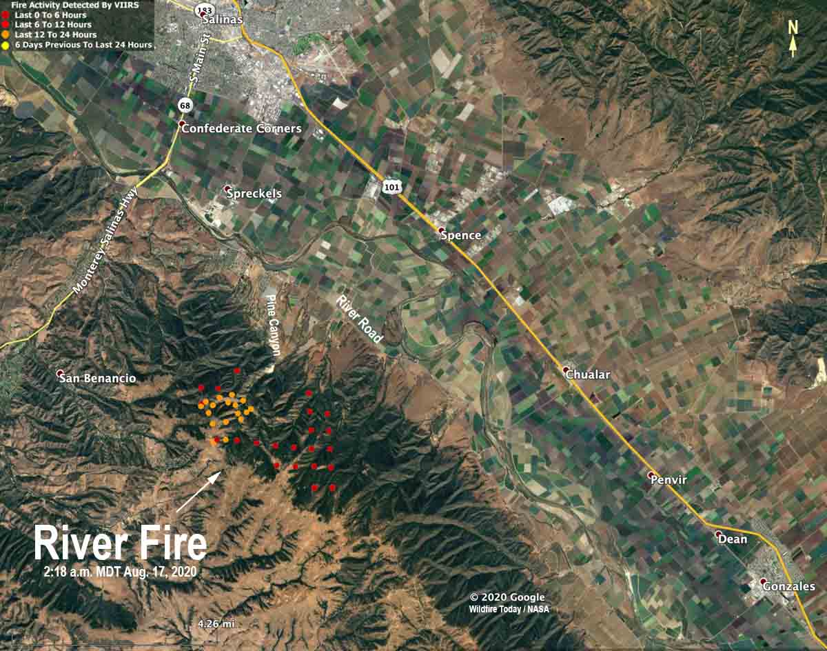
map River Fire Salinas California
The red and yellow dots on the map represent heat detected by a satellite on the River Fire at 2:18 a.m. PDT August 17, 2020. The locations are estimates and the fire has continued to spread since then.

Monday morning at 6 a.m. PDT CAL FIRE reported that the River Fire five miles south of Salinas has burned 2,800 acres and threatens 1,500 structures. Five structures have been damaged but none destroyed. Four firefighters have suffered heat-related injuries.

The fire has crossed Pine Canyon Road, CAL FIRE said, and is moving south toward River Road.

Mandatory evacuations were in effect at 6 a.m. PDT August 17 for Pine Canyon Road, Parker Road, Laurel Lane, and Trimble Hill Lane. The evacuation center is at Buena Vista Middle School, 18250 Tara Drive in Salinas. More information about evacuations can be found at CAL FIRE.


August 16, 2020 | 8 p.m. PDT

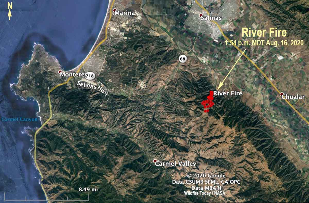
map River Fire
The red dots represent heat detected by a satellite on the River Fire at 1:54 p.m. PDT August 16, 2020.

CAL FIRE said at 5:40 p.m. Sunday that the River Fire reported at 3:14 a.m. PDT Sunday morning had burned 500 acres. It is in northern California about 5 miles south of Salinas and 6 miles northeast of Carmel Valley. Evacuations are in effect.

Sunday afternoon the wind recorded at the Rana Creek Tower near the fire was out of the north at 6 to 12  mph with gusts between 12 and 18. After 6 p.m. it switched to come out of the southwest at 10 mph with gusts to 13, pushing the fire to the northeast toward the valley. The relative humidity in the afternoon was around 30 percent with the temperature in the high 80s.

The forecast for Monday is for a high temperature around 90, relative humidity in the afternoon of 35 percent, and wind out of the west at 5 to 10 with gusts up to 21 in the afternoon.

The area has not been visited by fire for many years, so there should be abundant fuel available, offering firefighters a high resistance to control.

Mendocino Complex of Fires grows larger across three counties

Together the two fires, which have not merged, have burned 290,000 acres

(Originally published at 12:39 p.m. PDT August 7, 2018)

The two wildfires that comprise the Mendocino Complex of Fires continue to chew up acres in three counties in northern California — Mendocino, Lake, and Colusa Counties.

The Ranch Fire, north and east of Clear Lake, has been expanding on all sides for the last two days except for the northwest side. Firefighters have slowed the growth near Upper Lake, Nice and Lucerne, but it has kept moving on the southeast side around Indian Valley reservoir and on the northeast side in the remote areas west of Lodoga.

To see all of the articles on Wildfire Today about the Mendocino Complex, including the most recent, click HERE.

The River Fire west of Clear Lake has only spread substantially in recent days on the north side east of Talmage. In spite of reports that the two fires have merged, as of Monday night they were more than two miles apart.

If the size of the two fires are considered together, they have burned 290,692 acres, which would make the complex of two fires, which are managed together, the largest in modern recorded state history. But if added to the list, it would need an asterisk since it is two fires. The Ranch Fire has blackened 241,772 acres, and considered alone it qualifies as the 5th largest in modern California history. To reach the number one position it would have to exceed the 281,893 acres attributed to last December’s Thomas Fire near Santa Barbara. The River Fire has burned 48,920 acres.

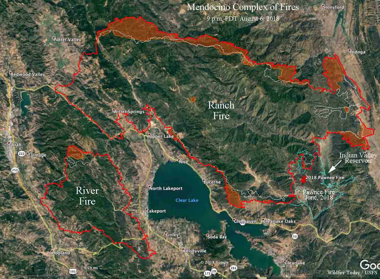
map Mendocino complex Fires California wildfires
Map showing the perimeter, in red, of the Mendocino Complex of Fires at 9 p.m. MDT, August 6, 2018. The white line was the perimeter two days before. The red shaded areas represent intense heat. Click to enlarge.

Mendocino Complex burns more than 273,000 acres

(Originally published at 8:12 a.m. PDT August 6, 2018)

The Mendocino Complex of Fires east of Ukiah, California has blackened more than 273,664 acres, becoming the second largest wildfire in the state’s recorded history if the size of the two fires in the “complex” are combined. Since we last reported on the fire two days ago it has grown by 120,000 acres, according to the numbers released by CAL FIRE Monday morning.

(To see all articles on Wildfire Today about the Mendocino Complex of Fires, including the most recent, click HERE.)

The Ranch Fire, north of Clear Lake, over the last two days has spread five miles east, one to two miles north, and three miles south. Sunday it spread into the footprint of the Pawnee Fire that in June of this year burned 14,000 acres west and south of Indian Valley Reservoir north of Highway 20.  The blaze is threatening communities on the east shore of Clear Lake, including Nice, Lucerne, Pepperwood, Glenhaven, and Clearlake Oaks.

The other fire that makes up the “complex” is the River Fire west of Clear Lake. About three-quarters of the perimeter has been quiet recently, but it is still moving aggressively north, coming to within less than two miles of merging with the Ranch Fire to the north. The report by one local media outlet that they had already merged was premature.

largest California wildfires fires
The table released by CAL FIRE on August 4, 2018 does not include the Mendocino Complex, since it is still very actively growing.

On the two fires 75 residences have been destroyed and another 9,300 remain threatened.

Resources assigned to the fire include 432 fire engines, 89 water tenders, 15 helicopters, 57 hand crews, and 80 dozers, for a total of 3,781 personnel.

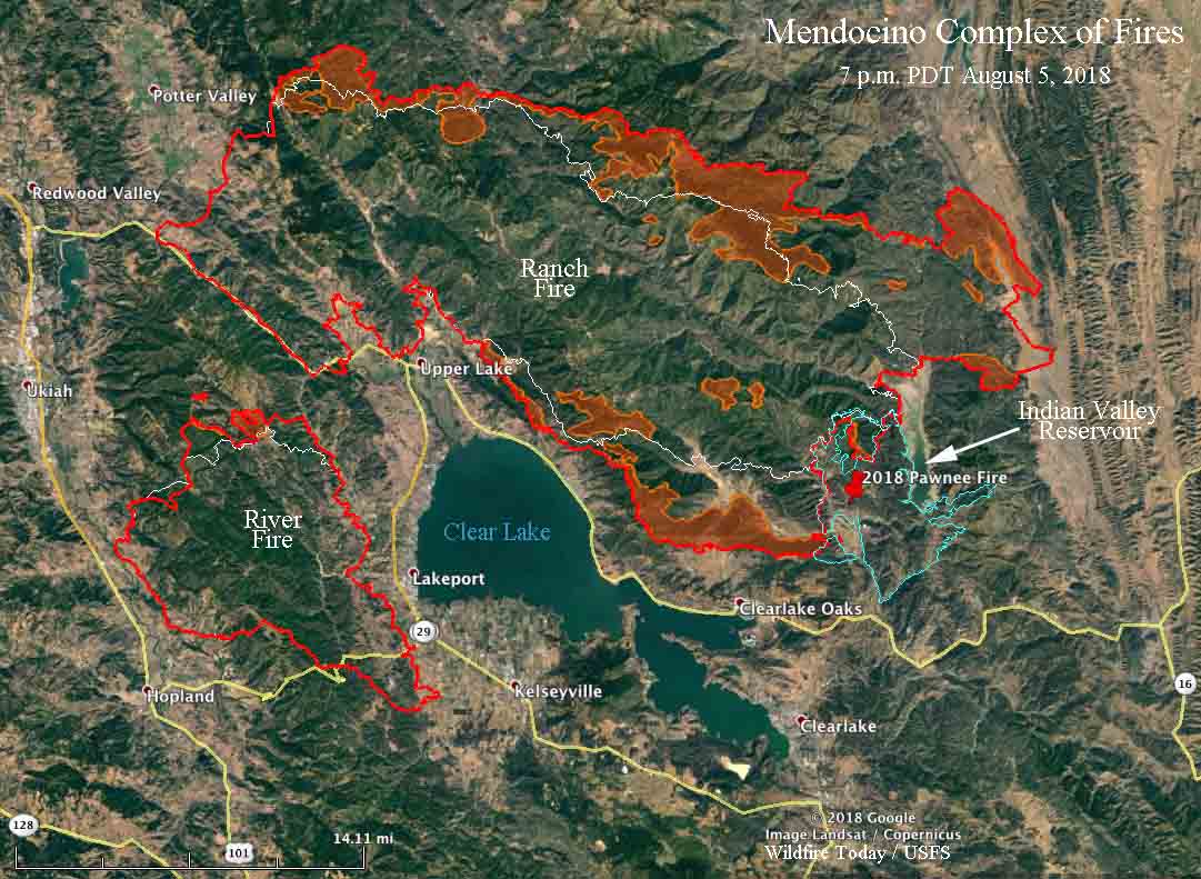
map Mendocino Complex fires
Map showing the perimeter, in red, of the Mendocino Complex of Fires at 7 p.m. MDT, August 5, 2018. The white line was the perimeter two days before. The red shaded areas represent intense heat. Click to enlarge.

Nationwide on wildfires 558 hand crews, 186 helicopters, and 1,907 fire engines are assigned on wildfires, for a total 28,234 personnel including overhead and other firefighting resources.

Australia and New Zealand have sent 138 fire personnel to assist. They are currently deployed in California, Oregon, and Washington.


The Mendocino Complex of Fires grows by 43,000 acres

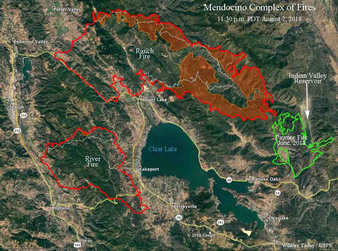
The Ranch Fire will most likely burn into the Pawnee Fire of June, 2018.

(Originally published at 11:02 a.m. PDT August 3, 2018)

The Mendocino Complex of Fires east of Ukiah, California were extremely active Thursday, adding another 43,000 acres west and east of Clear Lake. Firefighters were again engaged in house to house structure protection as the fire moved through the wildland-urban interface.

The northernmost of the two fires, the Ranch Fire, ran for about 6 miles to the southeast, coming very close to the burn scar from the Pawnee Fire of June, 2018, according to the infrared sensing data from a fixed wing aircraft collected at 11:30 p.m. August 2. The Ranch Fire also grew significantly on the northeast side.

Mendocino complex fires river ranch
Map showing the perimeter, in red, of the Mendocino Complex of Fires at 11:30 p.m. MDT, August 2, 2018. The white line was the perimeter 24 hours before. The red shaded areas represent intense heat. Click to enlarge.

The River Fire west of Clear Lake only showed major growth on its north side, where it moved to the north for up to a mile along an eight-mile long active edge.

Photographer Kent Porter wrote on Twitter (see below) that more evacuations were ordered north of Clear Lake. He said “the firefight was intense in Scotts Valley” Thursday. His photos confirm that statement.

To see all of the articles on Wildfire Today about the Mendocino Complex of Fires, including the most recent, click HERE.

Both fires are remaining active throughout the night. On Friday firefighters will prep and construct primary and secondary control lines. Difficult access and hot, dry weather make it difficult to fight fire directly in many areas.

CAL FIRE reports that 41 residences have been destroyed, up from 14 in Thursday’s update. The two fires have burned a total of 153,738 acres — 112,226 on the Ranch Fire and 41,512 on the River Fire, according to the numbers released by CAL FIRE Friday morning. That is a total increase of over 43,000 acres since Thursday.

Kent Porter got some great photos at the fire on Thursday, including one of the 747 Supertanker. Click on the pictures below to see larger versions.

North part of Mendocino Complex of Fires was very active Wednesday

Late in the day the Ranch Fire ran for at least five miles to the southeast

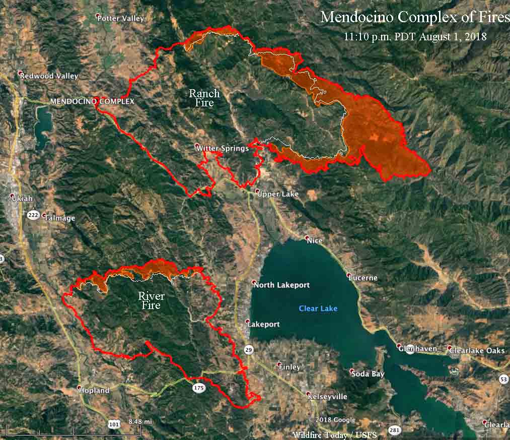
The northernmost of the two fires in the Mendocino Complex east of Ukiah, California, the Ranch Fire, was very active late in the day on Wednesday, running for at least five miles to the southeast according to the very reliable information from a mapping aircraft at 11:10 p.m. August 1. It is possible it may have spread for an additional three miles three to five hours later, but the data from the later overflights by the MODIS and VIIRS satellites could have been detecting heat and debris in a powerful convection column, rather than fire on the ground. All of the significant activity on the Ranch Fire Wednesday was on the northeast and east sides.

map Mendocino Complex River Fire Ranch fire
Map showing the perimeter, in red, of the Mendocino Complex of Fires at 11:10 p.m. MDT, August 1, 2018. The white line was the perimeter about 24 hours before. The red shaded areas represent intense heat. Click to enlarge.

With the expansion of the Ranch Fire it is now about three to five miles northeast of the community of Nice and four to seven miles northeast of Lucerne; both of these communities are on the east shore of Clear Lake.

To see all of the articles on Wildfire Today about the Mendocino Complex of Fires, including the most recent, click HERE.

Apparently firefighters on the River Fire have been very successful on the south and east flanks, with those locations showing little to no growth Wednesday in the Lakeport and Finley areas. The north side, however, was quite active, spreading north for about a half mile across the north perimeter.

CAL FIRE reports that 14 residences have been destroyed. The two fires have burned a total of 110,168 acres — 74,890 on the Ranch Fire and 35,278 on the River Fire, according to the numbers released by CAL FIRE Thursday morning.