FSU researchers: Most fires in Florida go undetected

By: Zachary Boehm

A new study by Florida State University researchers indicates that common satellite imaging technologies have vastly underestimated the number of fires in Florida.

Holmes Nowell
Christopher Holmes, assistant professor in the department of Earth, Ocean and Atmospheric Science, and Holly Nowell, postdoctoral researcher in EOAS.

Their report, published in collaboration with researchers from the Tall Timbers Research Station and Land Conservancy, challenges well-established beliefs about the nature and frequency of fire in the Sunshine State. While there were more fires than expected, researchers said, strategically prescribed burns throughout the state are proving an effective force against the ravages of wildfire.

The paper appears in the journal Geophysical Research Letters.

For scientists studying fire, sophisticated satellites whizzing far above the Earth’s surface have long represented the best tool for monitoring wildfires and prescribed burns — carefully controlled and generally small fires intended to reduce the risk of unmanageable wildfires.

But FSU researchers suggest that fire experts themselves have been getting burned by faulty data, and that broadly accepted estimates of fire area and fire-based air pollutants might be flawed.

“There are well-known challenges in detecting fires from satellites,” said lead investigator Holly Nowell, a postdoctoral researcher in the Department of Earth, Ocean and Atmospheric Science. “Here we show that only 25 percent of burned area in Florida is detected.”

Using comprehensive ground-based fire records from the Florida Forest Service — which regulates and authorizes every request for a prescribed burn in the state — researchers found dramatic discrepancies between fires detected by satellites and fires documented by state managers.

prescribed fire Florida
Austin Dixon of the Tall Timbers Research Station and Land Conservancy monitors a prescribed burn. Credit: Kevin Robertson

The majority of fires in Florida come in the form of prescribed burns, but because these fires are designed to be brief and contained, they often fall under the radar of satellites soaring overhead.

This is especially true in a state like Florida, where dense cloud cover is common and the warm, wet climate allows vegetation to regrow quickly after a blaze, disguising the scars that fires leave in their wake.

“Like a detective, satellites can catch a fire ‘in the act’ or from the ‘fingerprints’ they leave behind,” said study co-author Christopher Holmes, an assistant professor in EOAS. “In our area, catching an active fire in a thermal image can be hard because the prescribed fires are short, and we have frequent clouds that obscure the view from space.”

The state fire records also revealed a counterintuitive truth: Unlike in western states such as California, where dry conditions frequently produce massive increases in destructive and often uncontrollable fires, Florida actually experiences a decrease in land consumed by fire during drought.

When drought conditions emerge, researchers said, officials are less likely to authorize prescribed burns. And because prescribed burns account for the overwhelming majority of fires in the state, overall fire activity decreases.

This also suggests that prescribed burning programs — which aim to reduce the risk of wildfire in dry conditions — are having a materially positive effect.

“Although we still have occasional destructive wildfires, including the recent tragic Eastpoint fire, our results indicate that prescribed fire policy is helping to reduce wildfire risk,” Holmes said, referencing the June 2018 wildfire that destroyed dozens of homes in Florida’s Big Bend region.

Tall Timbers specialist Tracy Hmielowski uses a drip torch to ignite vegetation as part of a prescribed burn. Credit: Kevin Robertson
While the team’s study reconfirms the utility of prescribed burning, it calls into question prevailing estimates for airborne pollution from fire. If, as the study suggests, only 25 percent of fires in Florida are detected by satellites, then there could be “a rather large bias and a significant potential underestimation of emissions,” Nowell said.

The study’s findings are specific to Florida, but researchers suspect that similar satellite limitations may be skewing fire detection — and, consequently, emission estimates — in neighboring regions and geographically analogous areas like the savannas of Africa or the agricultural belts of Europe and Asia.

“We believe this result easily extends to the rest of the Southeast United States — which burns more area than the rest of the United States combined in a typical year — and other similar regions throughout the world that use small prescribed burns as a land management technique,” Nowell said.

Kevin Robertson, Casey Teske and Kevin Hiers from Tall Timbers contributed to this study. The research was funded by the National Aeronautics and Space Administration.

Thanks and a tip of the hat go out to Tom.
Typos or errors, report them HERE.

Fascinating animation of satellite imagery

What do you find MOST interesting about this video?

Above: screen grab from the NASA video. This image is from August 31, 2017.

NASA’s Goddard Space Flight Center has put together an incredible animation that make it possible to track smoke, dust from Africa, and sea salt. “Sea salt?” you’re thinking? Yes, winds over the oceans pick up salt which becomes visible to sensors on the satellites making it possible to visualize wind patterns, including hurricanes, over the vast expanses of the oceans.

This visualization uses data from NASA satellites, combined with mathematical models in a computer simulation allow scientists to study the physical processes in our atmosphere.

I watched this five times seeing something different with each viewing. So what are you going to watch? Wildfire smoke in Canada? Smoke in Portugal? Smoke in the western U.S.? Smoke in the Southeast? Or dust coming from Africa? Or the wind patterns and hurricanes in the Atlantic? Or the smoke that begins on October 9 northeast of San Francisco generated from the destruction of thousands of homes? Or smoke from fires in Italy?

If you look VERY carefully, you will be able to see a little smoke from something very rare — a wildfire in Greenland, near the coast on the southwest side of the island intermittently between August 2 and 15. (More info about the fire in Greenland.)

I suggest clicking on the full-screen button at the lower right after you start the video. If you’re having trouble viewing it, you can also see it on YouTube.

New GOES-16 satellite offers better detection of wildfires

The GOES-16 satellite that was launched in November is still being tested and is not fully operational, but some of its new capabilities are being explored. It has new sensors, some of which have a much better resolution and are better at detecting smoke. And it can rescan an area as often as every 30 seconds compared to 15 to 30 minute intervals on the older GOES-13 satellite. This makes it possible to produce much better animations of wildfire activity and smoke plumes.

Below is the description provided by NOAA for the video above, which has the imagery from the new GOES-16 on the left, compared to the older GOES-13 on the right.

This comparison of GOES-16 ABI and GOES-13 imager shortwave infrared (3.9 µm) data shows a number of grass fires burning near Lake Okeechobee in southern Florida on February 20, 2017. In the left panel, GOES-16 imagery at 30-second intervals is shown, while the right panel displays GOES-13 imagery at routine 15-30 minute intervals. The warmest shortwave infrared brightness temperatures are enhanced with yellow to red colors (with red being the hottest). Note the many advantages of the 30-second GOES-16 imagery: (1) new fire starts are detected sooner in time; (2) the fire behavior (intensification vs dissipation) can be better monitored; (3) the intensity of the fires is more accurately depicted with the 2-km resolution GOES-16 data vs the 8-km resolution GOES-13 data; (4) numerous brief fires are not detected at all in the 15-30 minute interval GOES-13 imagery (especially south and southeast of Lake Okeechobee, during the 2100-2115 UTC time period).

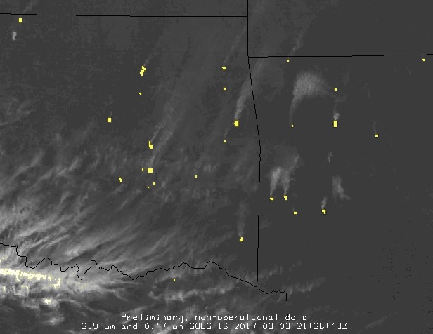
Bill Line of the NWS has posted a fascinating animated gif on his website that shows wildfires and smoke in Oklahoma today, Saturday.

Below is a screengrab from Mr. Line’s gif. The yellow areas represent heat.

GOES-16 fire smoke wildfire

An excerpt from his description:

The 0.47 um band will have higher reflectance in the presence of atmospheric aerosols (such as smoke) when compared to the legacy 0.64 um visible band. Combining these two bands into one display gives a forecaster a very helpful, quick view of wildfire activity across the region. The 2.25 um band can also be utilized to detect fire hotspots (especially very hot fires), particularly at night when the hotspot contrasts nicely with the surrounding darkness.

NASA to launch 200 satellites that will detect wildfires

CubeSat
CubeSat. NASA photo.

The National Aeronautics and Space Administration plans to launch a network of 200 small satellites that will detect wildfires within 15 minutes after a blaze grows to be at least 35 to 50 feet across. NASA’s Jet Propulsion Laboratory is working on a concept for a network of space-based sensors called FireSat in collaboration with Quadra Pi R2E. Within three minutes of detecting a fire from orbit, FireSat would notify emergency responders in the area of the fire.

Robert Staehle, lead designer of FireSat at JPL, and his team first presented the concept of FireSat in 2011 to the joint NASA/U.S. Forest Service Tactical Fire Remote Sensing Advisory Committee. They spent the subsequent years refining their understanding of fire monitoring needs and technological requirements.

“Such a system has only now become feasible at a reasonable cost, enabled by advances in commercial microelectronics that NASA, JPL and universities have tested in space via CubeSat experiments, and by software technology originally developed to give Mars rovers and Earth orbiters more autonomy in their science observations,” Staehle said.

This sounds like science fiction, but launches should begin in 2017 with a fully operational system of FireSat sensors in space by June of 2018.

CubeSats are 4 inches by 4 inches by 4 inches and weigh about 3 pounds. They are generally built from off the shelf components at a cost of thousands rather than millions of dollars.