Willdfire smoke exposure linked to increased risk of contracting COVID-19

A new study finds a 17.7 percent rise in COVID-19 cases after a prolonged 2020 wildfire smoke event in Reno, Nev.

Lava Fire
Lava Fire, pyrocumulus at 1:42 p.m. June 28, 2021.

By Kelsey Fitzgerald

Wildfire smoke may greatly increase susceptibility to SARS-CoV-2, the virus that causes COVID-19, according to new research from the Center for Genomic Medicine at the Desert Research Institute (DRI), Washoe County Health District (WCHD), and Renown Health (Renown) in Reno, Nevada.

In a study published earlier this week in the Journal of Exposure Science and Environmental Epidemiology, the DRI-led research team set out to examine whether smoke from 2020 wildfires in the Western U.S. was associated with an increase in SARS-CoV-2 infections in Reno.

To explore this, the study team used models to analyze the relationship between fine particulate matter (PM 2.5) from wildfire smoke and SARS-CoV-2 test positivity rate data from Renown Health, a large, integrated healthcare network serving Nevada, Lake Tahoe, and northeast California. According to their results, PM 2.5 from wildfire smoke was responsible for a 17.7 percent increase in the number of COVID-19 cases that occurred during a period of prolonged smoke that took place between Aug. 16 and Oct. 10, 2020.
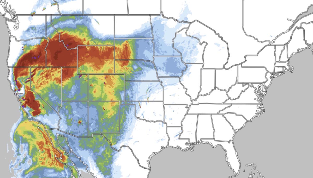
smoke forecast
During the time of the study, a map showed the forecast for the distribution of near-surface wildfire smoke at 6 p.m. MDT August 23, 2020. RealEarth.

“Our results showed a substantial increase in the COVID-19 positivity rate in Reno during a time when we were affected by heavy wildfire smoke from California wildfires,” said Daniel Kiser, M.S., co-lead author of the study and assistant research scientist of data science at DRI. “This is important to be aware of as we are already confronting heavy wildfire smoke from the Beckwourth Complex fire and with COVID-19 cases again rising in Nevada and other parts of the Western U.S.”

Reno, located in Washoe County (population 450,000) of northern Nevada, was exposed to higher concentrations of PM2.5 for longer periods of time in 2020 than other nearby metropolitan areas, including San Francisco. Reno experienced 43 days of elevated PM2.5 during the study period, as opposed to 26 days in the San Francisco Bay Area.

“We had a unique situation here in Reno last year where we were exposed to wildfire smoke more often than many other areas, including the Bay Area,” said Gai Elhanan, M.D., co-lead author of the study and associate research scientist of computer science at DRI. “We are located in an intermountain valley that restricts the dispersion of pollutants and possibly increases the magnitude of exposure, which makes it even more important for us to understand smoke impacts on human health.”

Kiser’s and Elhanan’s new research builds upon past work of studies in San Francisco and Orange County by controlling for additional variables such as the general prevalence of the virus, air temperature, and the number of tests administered, in a location that was heavily impacted by wildfire smoke.

“We believe that our study greatly strengthens the evidence that wildfire smoke can enhance the spread of SARS-CoV-2,” said Elhanan. “We would love public health officials across the U.S. to be a lot more aware of this because there are things we can do in terms of public preparedness in the community to allow people to escape smoke during wildfire events.”


More information:

Additional study authors include William Metcalf (DRI), Brendan Schnieder (WCHD), and Joseph Grzymski, a corresponding author (DRI/Renown). This research was funded by Renown Health and the Nevada Governor’s Office of Economic Development Coronavirus Relief Fund.

The full text of the study, “SARS-CoV-2 test positivity rate in Reno, Nevada: association with PM2.5 during the 2020 wildfire smoke events in the western United States,” is available from the Journal of Exposure Science and Environmental Epidemiology: https://www.nature.com/articles/s41370-021-00366-w


British Columbia bracing for very high temperatures as fires prompt evacuations

As of Wednesday night BC had 248 active fires, 36 of which were designated “fires of note”

Active wildfires and evacuation zones in Southern British Columbia
Active wildfires and evacuation areas in Southern British Columbia, 7 a.m. PDT July 30, 2021. The red lines represent wildfire perimeters. BC Wildfire Service.

British Columbia is having another year with higher than average wildfire activity due to hot, dry weather in recent weeks.

British Columbia Public Weather Alerts, 7 a.m. PDT July 30, 2021
BC Public Weather Alerts, 7 a.m. PDT July 30, 2021.

On Thursday in Lytton, BC the temperature reached 47.9 degrees Celsius (118F), the highest temperature ever recorded in Canada.

Hot weather is expected to continue through Saturday with many areas in the southern part of the province under Weather Alerts for heat where temperatures could reach or exceed 37 degrees Celsius (100F) while the relative humidity will be in the teens. The wind will be moderate in most areas, 5 to 7 mph with gusts to 8 or 10 mph.

Forrest Tower, a spokesman with the wildfire service, said, “We may get a bit of a break from the wind as this ridge kind of has a stable air mass over these fires, but the added challenge is that even if it may not be strong winds, any wind will have a significant influence on these fires.”

June’s extreme heat affected the fatality rate in BC. From the CBC July 29, 2021:

B.C.’s chief coroner has confirmed the majority of people who died suddenly during the week of June’s record-breaking heat wave lost their lives as a direct result of the extreme temperatures.

Lisa Lapointe confirmed in an interview Thursday morning that 570 of the 815 sudden deaths recorded over that time period — 70 per cent — have now been deemed “heat related.”

“[If not] for the extreme heat, they would not have died at that time,” Lapointe said during an interview with CBC’s The Early Edition.

According to Lapointe, 79 per cent of those who died were 65 or older.

As of Wednesday night BC had 248 active fires, 36 of which were designated “fires of note” that were highly visible or posed a potential threat to public safety. The 3,693 personnel assigned to the fires includes 316 from out of the province and Australia.

Currently there are 62 evacuation orders in effect for 3,443 properties.

For weeks the fires in BC have been producing dense smoke that generally spreads to the east and occasionally into the United States.

Here is the smoke forecast for 9 p.m. MDT July 31, 2021.

Smoke forecast
Smoke forecast for 9 p.m. MDT July 31, 2021. Firesmoke.ca.

Forecast for wildfire smoke July 14 & 15, 2021

1:48 p.m. MDT July 14, 2021

Smoke forecast for 8 p.m. MDT July 14, 2021
Smoke forecast for 8 p.m. MDT July 14, 2021. NOAA.

Above is NOAA’s forecast for the distribution of wildfire smoke at 8 p.m. MDT July 14, 2021.

Below is the Canadian’s version of a forecast for the distribution of wildfire smoke 24 hours later, at 8 p.m. MDT July 15, 2021.

Smoke forecast for 8 p.m. MDT July 15, 2021
Smoke forecast for 8 p.m. MDT July 15, 2021. Canadian government.

The photo below taken Wednesday morning in Northeast North Dakota shows visibility being compromised by smoke, which may have originated in Canada.

Smoke in North Dakota, July 14, 2021
Smoke in North Dakota, July 14, 2021. Photo by Misty Kirbitz.