Smoke linked to thousands of COVID-19 cases on West Coast

More than half of the 22 coronavirus fatalities in Calaveras County, CA were tied to smoke

Satellite photo, wildfires,
As the sun begins to set on the west coast, gray smoke from wildfires can be easily distinguished from white clouds. NOAA, GOES 17.

From the San Francisco Chronicle, Aug. 13, 2021


The presence of wildfire smoke last year during the pandemic may have been responsible for at least 19,000 additional coronavirus cases on the West Coast, and 700 subsequent deaths, a new study shows.

The study, published Friday in the journal Science Advances, offers the most detailed accounting yet of how the devastating 2020 wildfire season is believed to have amplified the coronavirus outbreak. It traces increases in infections to periods of smoke in more than 50 counties in California, Oregon and Washington.

While a correlation between wildfire smoke and COVID-19 doesn’t prove causation, the study’s authors say the tie is no coincidence. Plenty of research since the start of the pandemic has suggested that exposure to smoke’s primary unhealthy component PM 2.5, which refers to particulate matter that is 2.5 micrometers in size or smaller, compromises people’s immunity and increases susceptibility to COVID-19. Scientists also hypothesize that the virus may be spread by the particles.

The team’s models crunched coronavirus numbers in 92 counties during non-smokey periods from March 15 to Dec. 16 and how these numbers changed when wildfire smoke brought particulate pollution. The area that the researchers examined covered 95% of the population in California, Oregon and Washington. They excluded areas that did not have sufficient data for modeling.

Smoke forecast and air quality, August 8, 2021

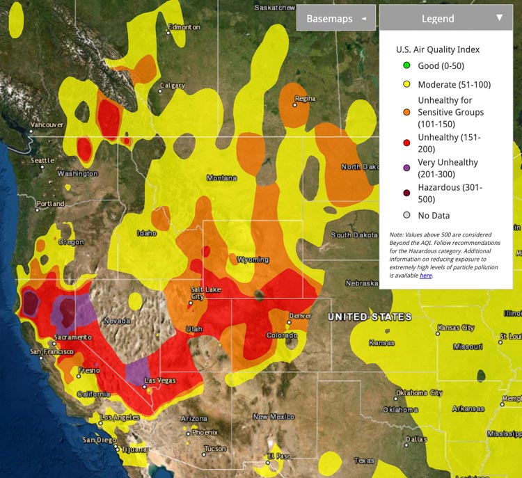
Air Quality (PM2.5 & PM10) at 7:07 p.m. PDT Aug 8, 2021
Air Quality (PM2.5 & PM10) at 7:07 p.m. PDT Aug 8, 2021. AirNow.

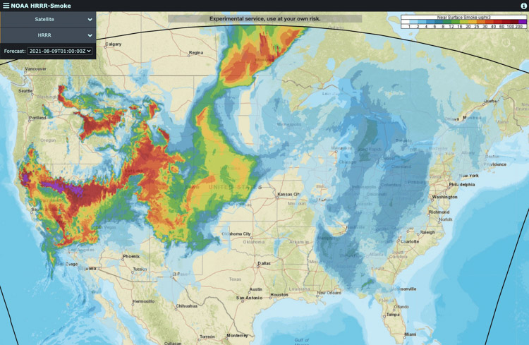
Wildfires in California, Oregon, Washington, Idaho, Montana, and Canada are creating smoke that is affecting air quality in most of the Western United States.

Smoke Forecast for 2 a.m. PDT August, 9 2021
Forecast for near surface smoke at 2 a.m. PDT August 9, 2021. NOAA.

Smoke and air quality maps, August 7, 2021

Air quality (Ozone, PM2.5, & PM10)
Air quality (Ozone, PM2.5, & PM10) at 12:18 p.m. PDT Aug 7, 2021. AirNow.

Wildfires in Canada and the Western United States are having massive impacts on air quality in some locations, depending on the wind direction.

Above is the measured air quality at noon Pacific time.

Below are forecasts for wildland fire smoke, at 6 p.m. Saturday, and then Sunday.

Smoke Forecast
Smoke Forecast for 6 p.m. PDT Aug 7 2021. FireSmoke.CA
Smoke Forecast
Smoke Forecast for 6 p.m. PDT Aug 8 2021. FireSmoke.CA

Smoke forecast and Red Flag Warnings

Smoke forecast for 4 a.m. MDT August 5, 2021.
Near-surface smoke forecast for 4 a.m. MDT August 5, 2021.

Most of the United States has some degree of smoke due to the fires in the western states and Canada, but the lighter concentrations may not be noticeable to most residents. If you have red sunrises and sunsets, it could be because of the smoke. Above is the near-surface smoke forecast for 4 a.m. MDT August 5, 2021.

Below are the Red Flag Warnings and Fire Weather Watches, issued August 4, 2021.

Red Flag Warnings, Aug 4, 2021
Red Flag Warnings, Aug 4, 2021.

Smoke forecast, 11 pm MDT July 31, 2021

Smoke forecast
Smoke forecast for 11 p.m. MDT July 31, 2021.

For the last couple of days wildfires in Southern British Columbia have been producing large quantities of smoke which has been drifting into Alberta, North-central US, the American Midwest, and points further east. The forecast for Saturday night indicates this trend is continuing.

Clouds have made it difficult for satellites to photograph smoke coming from the Bootleg Fire in Oregon and the Dixie Fire in California.

Satellite photo smoke wildfires British Columbia Montana
Satellite photo showing smoke from fires in BC and Montana at 7:40 p.m. MDT July 30, 2021.