South Dakota: USFS prescribed fire escapes, burns 14,000 acres

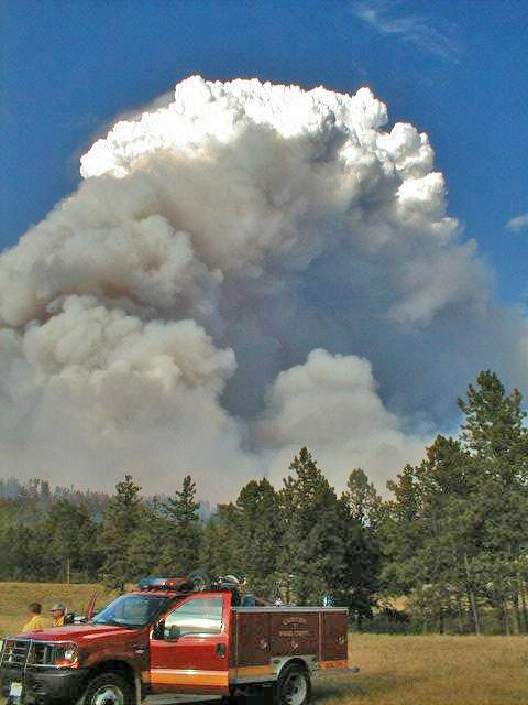
Pautre Fire. US Forest Service photo.

UPDATED at 11:25 a.m. MT, April 6, 2013:

Map Pautre Fire
Map of the Pautre Fire at 0000 on 4-4-2013, provided by USFS.

The US Forest Service has announced that their escaped prescribed fire is 90 percent contained and is now estimated to have burned 10,800 acres southeast of Hettinger, North Dakota and southwest of Lemmon, South Dakota. One outbuilding has burned, along with fences, hay, and pastures.

On Friday there were 16 engines and 2 water tenders assigned. Firefighters have been engaged in mopup, including trying to put out a burning dump site close to the fire perimeter.

There will be a public meeting at the North Dakota State University Research Center in Hettinger, ND on Saturday April 6 at 4:00 p.m. Information about the Pautre Fire and the claims process will be presented by the USFS.

****
UPDATED at 10:23 a.m. MT, April 5, 2013:

An article in The Rapid City Journal has more information about the impacts of the fire on the ranchers. Privately owned grazing, hay stacks, and miles of fencing were damaged or destroyed during the ranchers’ calving season. Here is an excerpt:

Laurie Casper, 36, said the fire destroyed 95 percent of her family’s farmland, which is more than 1,000 acres.

“We lost all of our calving pasture, we lost our summer grazing, we lost our fall grazing, we lost 100 percent of our alfalfa— which we cut for hay bales in order to feed the cattle this oncoming winter— all that’s completely gone,” she said. “And there’s just just miles and miles of fences that are completely gone.”

Casper’s family didn’t sleep on Wednesday night. The fire came at the worst time for them and other ranchers: the middle of calving season. While Casper’s family found refuge for their cattle in a neighbor’s cornfield, her family is now worried about their herd’s health. On Thursday morning, their cattle wouldn’t clean their calves because they smelled like smoke. They also fear their livestock may suffer respiratory issues after inhaling dust and smoke.

****

UPDATED at 10:21 p.m. MT, April 4, 2013:

The Pautre Fire is 75 percent contained and is still estimated to have burned 14,000 acres.

Eighteen fire engines and two water tenders are assigned to the fire and continue to work on strengthening the perimeter and providing structure protection. Full containment of the fire is expected by Friday evening.

Paul Hancock, Grand River District Ranger said, “As suppression operations are ending, the Forest Service will be conducting an assessment to determine property damage and working on short and long term strategies to pay for the damage we caused.”

****

(Originally published at 12:34 p.m. MT, April 4, 2013)

A prescribed fire on the Grand River Ranger District of the Dakota Prairie National Grasslands escaped on Wednesday and burned 14,000 to 16,000 acres of grassland near Lemmon in northwest South Dakota (map). The fire was being conducted by the U.S. Forest Service, the agency that administers the National Grassland.

Babete Anderson, a spokesperson for the National Grassland, told Wildfire Today Thursday morning that the spread of the wildfire now named the Pautre Fire, has been stopped and no structures were destroyed. A little snow Thursday morning assisted firefighters with mopup

The original plan for the prescribed fire called for treating 130 acres with fire. At about 2 p.m. on Wednesday winds gusting up to 30 mph pushed the fire across control lines. Approximately 50 to 60 percent of the acres that burned were on private land. Firefighters are calling it 50 percent contained on Thursday and expect strong winds again late in the afternoon on Thursday.

“The Forest Service regrets that the prescribed burn escaped the containment lines and affected so many people. I appreciate the support and efforts from the firefighters, their families and the communities affected by this fire.” stated Paul Hancock, Grand River District Ranger.

Jasper Fire, 13 years later

Jasper Fire south dakota
Jasper Fire pyrocumulus, about two hours after the fire started, August 24, 2000. NPS photo by Bill Gabbert.

It has been almost 13 years since the Jasper Fire raged across 83,000 acres of the Black Hills of South Dakota. It started when a woman stopped on Highway 16 a couple of miles west of Jewel Cave National Monument to pee, she said later. Before she left, she lit a match, dropped it, and watched as it ignited a few pine needles and then started spreading across the forest floor. When I got to the area about two hours later I took the photo above of the pyrocumulus cloud over the fire.

Over the next several days the wind direction changed frequently driving the fire in different directions. It burned into the Black Hills National Forest and through Jewel Cave National Monument. But thanks to the prescribed fire program and fuel mitigation work that had been going on at Jewel Cave for a decade or so, no structures were damaged, except for an old historic outhouse which burned during mopup when the engine crew working nearby had their thumbs up their asses back turned.

As you can see in the article below by the Black Hills National Forest, rehab and mitigation is still going on.

****

Date: April 2, 2013

Forest Service Continues Management within the Jasper Fire Area

Custer, SD – Black Hills National Forest Officials continue management actions within the Jasper and Roger’s Shack Fire areas that occurred on the Hell Canyon Ranger District west of Custer nearly 13 years ago. These two fire areas total about 90,000 acres.

Tree planting is scheduled to begin in April, to assist with reforestation of the Jasper area. Research plots established within the fire boundary have resulted in and continue to provide opportunity for valuable local research on fire effects and post-fire recovery.

Hell Canyon District Ranger, Lynn Kolund recently signed a decision which will allow for approximately 16,500 acres of fire hazard reduction in these fire areas. Over the course of about 10 years, prescribed burning will be used to reduce the fire hazard in these areas. In addition, the decision includes about 650 acres of thinning to improve the health and vigor of islands of forest stands within these areas. “Over the next several years we will work on this project to make the area more resilient for the future,” said District Ranger Lynn Kolund.

Fire officials are concerned about the fire danger this area presents as most of the dead trees have fallen over and grass has grown up around them. In some areas, the resulting fuel concentrations are 5 feet deep. According to Kolund, “Fires in these areas quickly spread like a grass fire but have the heat of a timber fire; they’re very dangerous to firefighters.”

Forest officials are focused on restoring the land, but safety is a top priority when it comes to fire danger. “There is a tremendous amount of fuel loading out there and it is a dangerous situation” said Gwen Lipp, Fire Management Officer for the Hell Canyon Ranger District. “When we get a wildfire in this area, it will be extremely difficult to control. This project will reduce the long term fire hazard and also improve the ability for firefighters to move quickly to put out a fire in the future.”

In addition to the prescribed burning, Forest officials will be thinning vegetation and planting new ponderosa pine trees. Kolund said, “We are doing our job as a land management agency. Restoration of this area of the Forest will ensure its availability for future generations.”

For more information on the Hell Canyon Maintenance Burn project, visit http://www.fs.fed.us/nepa/fs-usda-pop.php/?project=22242

(end of USFS article)

Jasper Fire
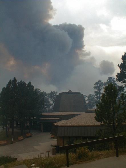
The Jasper Fire approaches the Visitor Center at Jewel Cave National Monument, August 25, 2000. NPS photo by Bill Gabbert.
Jasper Fire
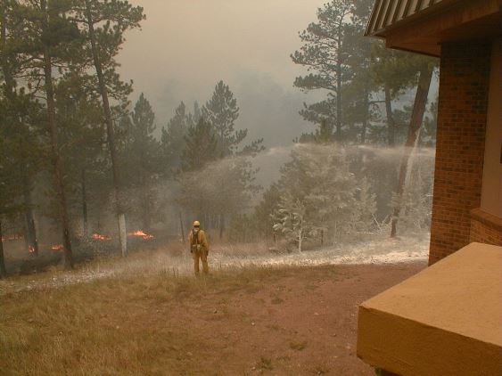
Firefighters use foam to protect the Visitor Center at Jewel Cave National Monument during the Jasper Fire, August 25, 2000. NPS photo by Bill Gabbert.


Prescribed fire along the Fall River

Nearly every year the city of Hot Springs, South Dakota asks the Hot Springs Volunteer Fire Department to conduct a prescribed fire along the Fall River. The burning reduces the woody vegetation which could clog the flood control channel where the river passes through the city. Before it was channelized and the Cold Brook Dam was constructed upstream, the city suffered frequent floods.

These photos were taken by Bill Gabbert, Saturday, March 30, 2013.

Fall River Prescribed Fire

The photo above shows a section of the river just as the burning began. Below is the same area on hour or two after the fire passed through.

Fall River Prescribed Fire

Even though there had been a light rain the night before and the relative humidity was in the mid-50s, the cattails burned very well.

Fall River Prescribed Fire Fall River Prescribed Fire

I shot all of these photos at 1/500th second, and was pleased with the way it captured the flames, such as in the image above where a ball of fire can be seen about 20 feet above the main flame front. I used two cameras, both Canon T3i’s. The lenses were also Canon, 100-400mm and 17-85mm lens.

Fall River Rx fire 034smaller

The flames impinged on the wood deck of the pedestrian bridge, but apparently there was no damage. More photos are below.
Continue reading “Prescribed fire along the Fall River”

South Dakota fire meteorologist analyzes wildfire potential

Percent of normal precipitation, Dec-Feb

South Dakota State Fire Meteorologist Darren Clabo gave a presentation in Rapid City Thursday covering the current fire weather conditions and the potential for the coming months. Below is an excerpt from an article in the Rapid City Journal:

April, May, June and July are typically the region’s wettest months, when the area receives 50 percent of its annual average of 21 inches precipitation. With the exception of the Northern Hills and northeastern South Dakota, most of the state had no appreciable snow pack this winter after a warmer-than-average summer that depleted soil moisture, Clabo said.

“My biggest concern is the southern Black Hills, southwestern South Dakota, down to the Pine Ridge Escarpment,” Clabo said. “I’m concerned about western South Dakota. I’m concerned about the Missouri River Valley.”

Last year, much of the Northern Great Plains and Rocky Mountain regions saw less than 50 percent of their average rainfall. Temperatures were also 3 to 5 degrees above average.

“2012 was the hottest year on record in North America. That’s extreme,” Clabo said.

And, there are indications that a warm spring and summer are on the horizon, Clabo said.

Although an improvement in drought conditions is predicted, Clabo is less than optimistic about the possibility of any significant drought relief. He points out that most of western South Dakota is in an extreme or severe drought, according to the national Drought Monitor.

Wildland fire academy in Ft. Pierre

S-290 at Ft Pierre
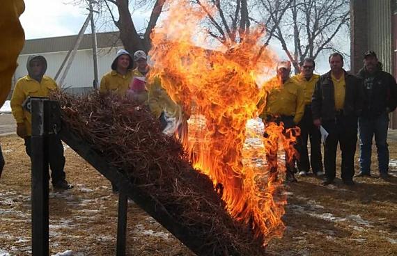
Students in the Ft. Pierre Intermediate Fire Behavior class, S-290, observe a demonstration fire. Photo provided by the Wildland Fire Suppression Division.

This weekend the South Dakota Wildland Fire Suppression Division hosted a wildland fire academy in Ft. Pierre, South Dakota. About 266 firefighters were able to choose from 18 classes being offered.

Spokesperson Jeni Lawver said they plan to conduct live fire exercises on Sunday — on a larger scale than seen in the above photo.