Rankin Fire burns hundreds of acres in Wind Cave NP

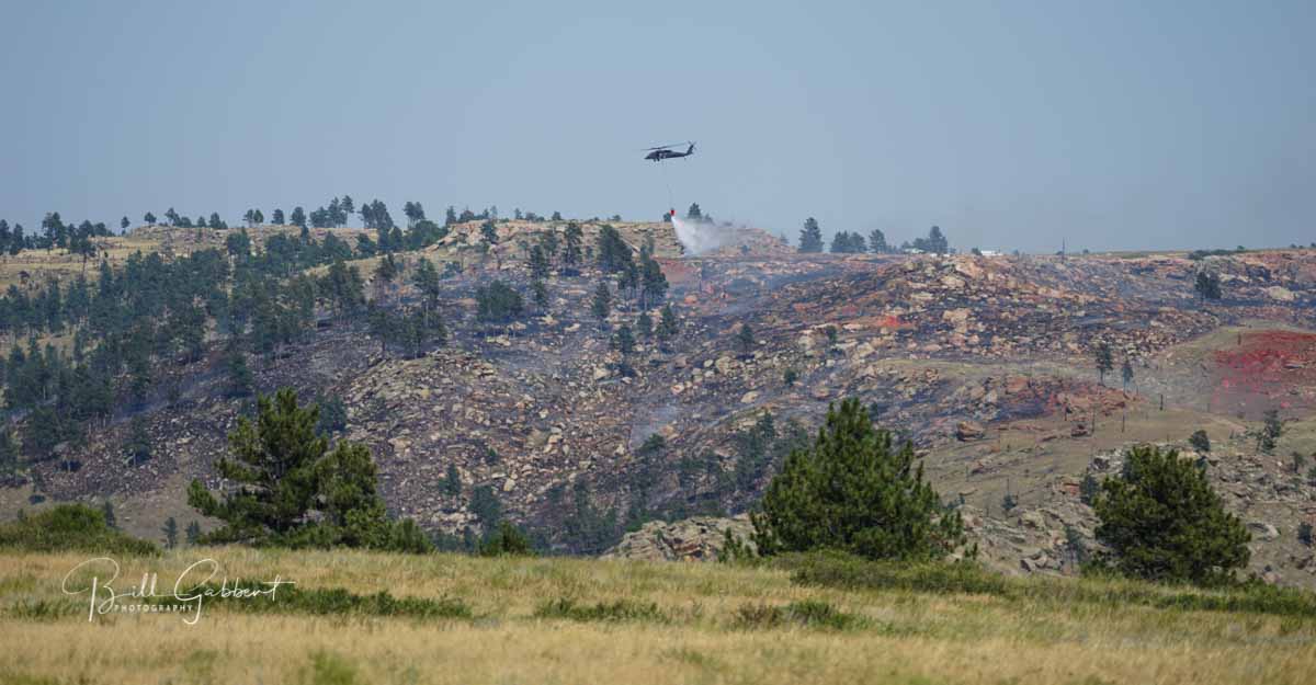
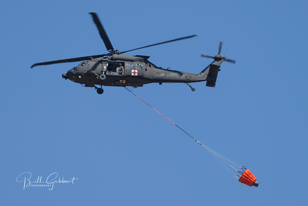
Above: Firefighters conduct a burnout operation on the Rankin Fire in Wind Cave National Park, September 12, 2017. NPS photo.

(UPDATED at 6:34 a.m. MDT September 12, 2017)

A thunderstorm Tuesday afternoon prevented the acquisition of updated satellite mapping information about the Rankin Fire during the regular afternoon overflight, but during the next pass at 2:14 a.m. MDT Wednesday the clouds had dispersed.

For the most current information on Wildfire Today about the Rankin Fire, click HERE.

The map below shows additional fire spread detected by the satellite to the south.
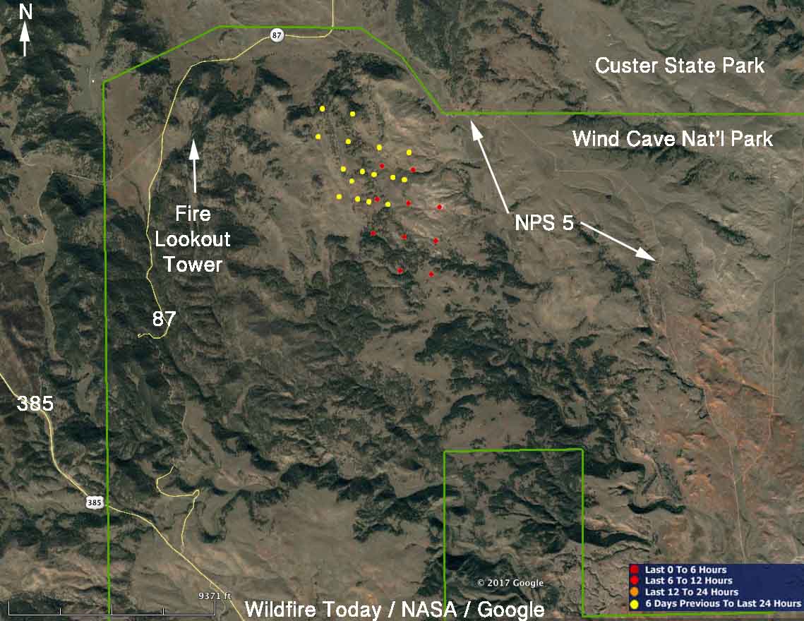
map Rankin Fire
The red and yellow dots represent heat detected on the Rankin Fire by a satellite. The red dots are the most current, seen at 2:14 a.m. MDT September 13, 2017. Areas with light vegetation, such as grass, may have burned and completely cooled before the satellite overflight, so the fire may be significantly larger than shown here.

There was a report that air tanker 101, an MD-87, was dispatched from Grand Junction to the fire on Tuesday.
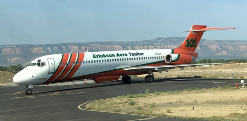
 air tanker 101 MD-87
Air tanker 101, an MD-87, at Grand Junction, Colorado September 8, 2017. Photo by Dave Perkins.

The thunderstorm Tuesday afternoon brought strong winds to the fire area, that no doubt challenged firefighters who were attempting to limit the spread. The winds measured at Elk Mountain south of the fire were from various directions at 8 to 24 mph with gusts of 24 to 44 mph. When the storm passed over the fire the temperature dropped 15 degrees within an hour, from 95 to 80 and the relative humidity increased temporarily from 16 to 29 percent, but within three hours dropped back to 21 percent.

A weather station at Mount Rushmore, 17 miles north of the Rankin Fire, recorded 0.02″ of rain Tuesday afternoon, but there was none at Elk Mountain.

****

(UPDATED at 9:30 p.m. MDT September 12, 2017)

The Rocky Mountain Coordination Center reports that the lightning-caused Rankin Fire in Wind Cave National Park in southwest South Dakota has burned 760 acres.

Monday night and Tuesday firefighters conducted burning operations from a mowed line, NPS 5, and trails to help secure portions of the perimeter.

Gusty winds from a slow-moving thunderstorm cell on Tuesday caused the wind to shift from the south to the north, sending smoke into Hot Springs during the afternoon.

The fire is east of Rankin Ridge fire lookout tower between Highway 87 and NPS 5. (NPS 5 is the dirt road running generally north-south that connects Highway 87 with the 7-11/101 road south of the park.

A Type 3 Incident Management Team has assumed command of the fire.

Currently the only closures in Wind Cave National Park are the northern segment of NPS 5 and all backcountry hiking trails north of Wind Cave Canyon. The park visitor center remains open with cave tours leaving from 9 a.m. to 4:30 p.m. throughout the day.

****

(Updated at 12:07 p.m. MDT September 12, 2017)

Here’s a map showing the location of the Rankin Fire in Wind Cave National Park as of 2:37 a.m. on Tuesday. The red squares represent heat detected at the fire by a satellite.
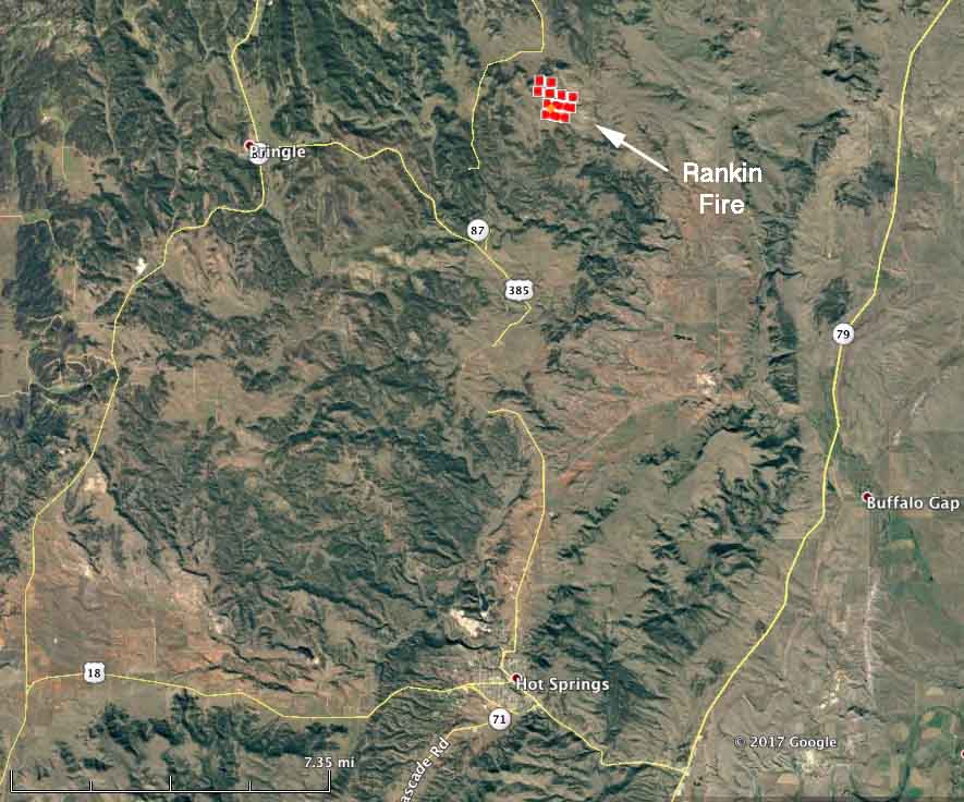
map rankin fire
The red squares represent heat detected by a satellite at 2:37 a.m. MDT September 1, 2017.

The Rankin Fire has burned approximately 300 acres as of Tuesday morning.

Monday night firefighters burned out from Hwy. 87 and NPS 5.

At noon on Tuesday the resources assigned to the fire, in addition to numerous fire engines, are one National Guard Blackhawk helicopter, one Air Attack, and a Single Engine Air Tanker is ordered.

Very little information about the fire is being made available.

****


(Updated at published at 9:25 p.m. MDT September 11, 2017)

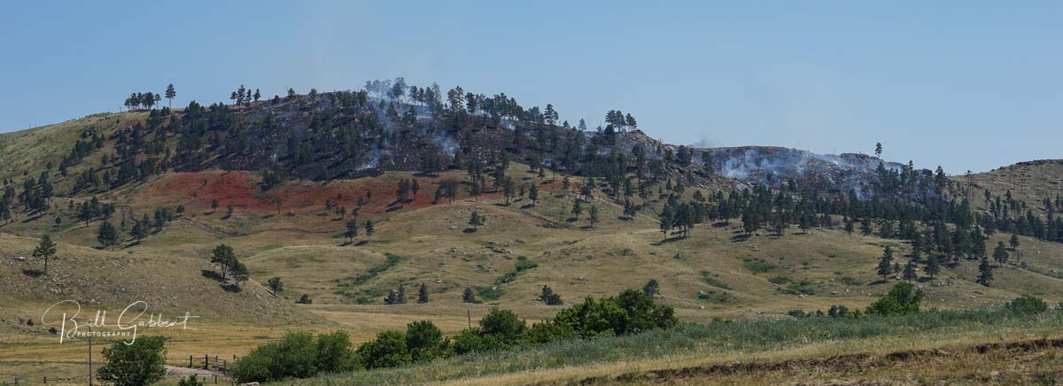
A small thunderstorm passing over the southern Black Hills Sunday night left a souvenir that was discovered around 2 p.m. Monday. The Rankin Fire, caused by lightning, is burning near the Ridge and Lookout Tower of the same name, in Wind Cave National Park in South Dakota.
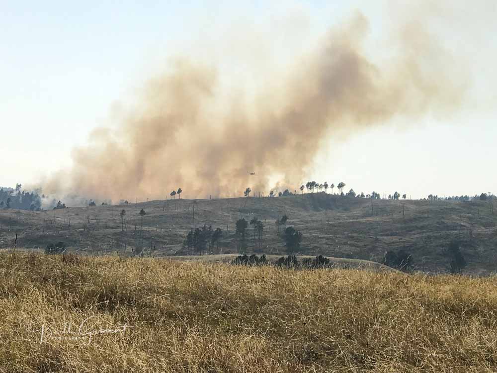
Rankin Fire south dakota
Rankin Fire, 4:51 p.m. MDT September 11, 2017. Photo by Bill Gabbert.

Spokesperson Kelsey Bean told us at 7:25 p.m. Monday that the fire had burned approximately 20 to 30 acres and no large air tankers had been used so far at that point, but a National Guard Blackhawk helicopter and two single engine air tankers (SEATs) assisted firefighters on the ground. The SEATs came from Casper and Cody, Wyoming.

Nine fire engines from state and federal agencies were on scene this evening and more had been ordered, Ms. Bean said.

We will update this article as more information becomes available.
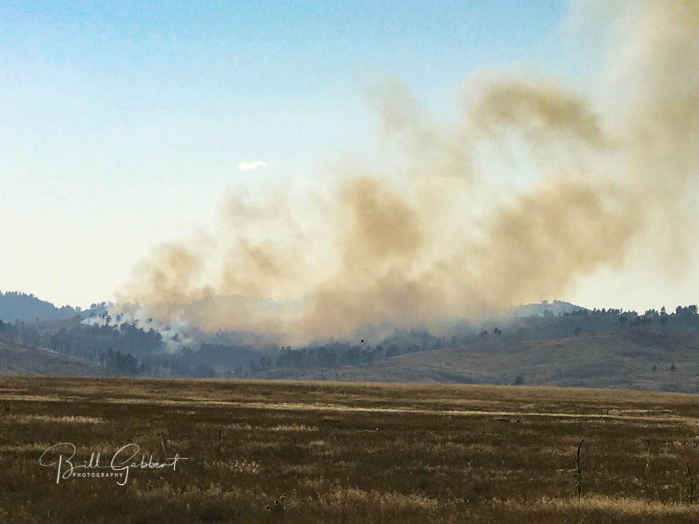
Rankin Fire south dakota
Rankin Fire, 4:57 p.m. MDT September 11, 2017. Photo by Bill Gabbert.

Elk Run Fire causes evacuations in the Black Hills

Residents near Argyle south of Pringle were asked to leave their homes.

(Updated at 2:15 p.m. MDT August 31, 2017)

After more accurate mapping using GPS equipment, the size of the Elk Run Fire was determined to be 225 acres. All evacuation orders have been lifted.

****

Within a few hours after it was reported on private land at 3:16 p.m. MDT Wednesday, the Elk Run Fire near Argyle, South Dakota burned approximately 400 acres. Fire officials said two structures were damaged and some homes in the community of Argyle were evacuated.

On Wednesday the blaze was attacked by firefighters on the ground as well as three single engine air tankers, one heavy air tanker, and a South Dakota National Guard Blackhawk helicopter.

Elk Run Fire map
Map showing the approximate location of the Elk Run Fire in South Dakota, 7:56 p.m. MDT August 31, 2017

Fire officials hope to have a more accurate measurement of the number of acres burned later on Thursday.

Animating still photos of fires

Today I have been experimenting with an app that recently became available for iPhones and iPads, called Plotagraph. It can be used to animate still photos and seems like a natural for manipulating photographs of fires. You can’t use the app to create new stuff in the photo, but you can take what’s there and make it move.

So far I’ve worked on three photos. One had flames that were fairly easy to isolate and another had smoke that was easy to work with. The third was a B-17 dropping retardant.

The way it works is, first you identify what areas in the photo you do not want to animate, then you indicate the direction and speed for the motion. When finished, it can be saved as a video.

The first one, below, shows a member of the Alpine Hotshots who was working on the 2014 Norbeck Prescribed Fire in Custer State Park.

The next one is from the 2012 White Draw Fire.

And finally, retardant from a B-17.

If you’re having trouble viewing the videos, you can see them on YouTube.

To get your own prints of the original still images…..

Art Prints

Photography Prints

Sell Art Online

One person dead at fire in Fairburn, SD; structures and vegetation burned

(Originally published at 12:53 p.m. MDT July 25, 2017)
(Updated at 4:52 p.m. MDT July 25, 2017)

There was a fatality at a fire in Fairburn, South Dakota Monday morning when a civilian died near one of two burned structures. Jim Strain, Assistant Chief of the Fairburn Volunteer Fire Department who was Incident Commander on the fire, said one of the structures, a single-family residence, was occupied and the other, a two-story house, was vacant.

No other information was available about the fatality as of 4:45 p.m. on Tuesday.

After the fire started around 10 a.m. calls were received in several fire departments in the area saying multiple structures were burning in Fairburn and it was spotting into the grass — send everything you can.

Fairburn fire

At around 11:30 a.m. firefighters had the one acre of vegetation and the structure fires knocked down with the help of a single engine air tanker. Since there is no high-volume water source in the small town so water tenders were driving miles to refill.

Chief Strain said there was a great interagency effort from three counties, state, and federal agencies.

Fairburn fire Fairburn fire Fairburn fire Fairburn fire


Chilson Fire burns several dozen acres in Black Hills

Above: A South Dakota National Guard Blackhawk helicopter makes a water drop on the Chilson Fire, July 24, 2017.

(Originally published at 4:50 p.m. MDT July 24, 2017)

The Chilson Fire has burned approximately 40 acres in the Black Hills of South Dakota, halfway between Edgemont and Hot Springs south of Highway 18 and one mile southeast of Old Highway 18.

At 3 p.m. on Monday firefighters appeared to have the spread stopped, thanks to efforts by 4 engines, 3 hand crews, 3 helicopters (1 contracted Type 3 and 2 National Guard Blackhawks), and 1 single engine air tanker.

Chilson Fire
Chilson Fire, between Edgemont and Hot Springs, SD. Click to enlarge.

Since the Northern Great Plains received 28,000 cloud to ground lightning strikes on July 21 and 22, firefighters in the Black Hills have responded to around 20 fires. Most were suppressed at less than an acre, but four others burned 8, 10, and 36 acres; and this one, the Chilson Fire, that is estimated at 40 acres.

Chilson Fire
A South Dakota National Guard Blackhawk helicopter drops water on the Chilson Fire, July 24, 2017. Click to enlarge.
Chilson Fire blackhawk helicopter
A South Dakota National Guard Blackhawk helicopter works on the Chilson Fire. Click to enlarge.

Brady Fire — southeast of Edgemont, South Dakota 

Above: Brady Fire, June 29, 2017. Photo by Bill Gabbert.

(Updated at 2:09 p.m. MDT July 1, 2017)

The updated size of the Brady Fire is 172 acres. The increase from 95 acres reported yesterday is due to more accurate mapping — the fire has not grown.

****

(Updated at 12:40 p.m. MDT June 30, 2017)

The size of the Brady Fire 7 miles southeast of Edgemont, SD has been revised to 95 acres. Firefighters are estimating that about half an inch of rain fell on the fire Thursday night. In Hot Springs, 15 miles northeast of the fire, there was 0.12 inches overnight in addition to lots of lightning in the southern Black Hills.

Approximately 70 firefighters are on scene today, Friday, mopping up.

****

(Updated at 9:14 p.m. MDT June 29, 2017)

The Brady Fire, discovered Thursday afternoon, has burned dozens of acres southeast of Edgemont, South Dakota. We’ll post more information as it becomes available. The fire is burning in timber and grass on fairly steep slopes on the north side of the Cheyenne River.

The Great Plains Interagency Dispatch Center reported at 5 p.m. Thursday it had burned 25 acres. The fire continued spreading slowly after that time, but received rain from a thunderstorm at 8:15 p.m.

map Brady Fire South Dakota
Map showing the location of the Brady Fire, 7 miles southeast of Edgemont, SD.
Brady Fire South Dakota
Brady Fire, June 29, 2017. Photo by Bill Gabbert.
Brady Fire South Dakota
Brady Fire, June 29, 2017. Photo by Bill Gabbert.
Brady Fire South Dakota
Brady Fire, June 29, 2017. Photo by Bill Gabbert.