Rapidly spreading fire west of Gatlinburg, TN

map East Miller Cove Fire
Map showing the location of the East Miller Cove Fire at 10:30 p.m. ET November 18, 2016.

The East Miller Cove Fire 16 air miles west of Gatlinburg, Tennessee spread very rapidly Friday night as a cold front passed through with winds shifting from south to west gusted at 12 to 23 MPH. However the nearby Indian Grave weather station in Great Smoky Mountains National Park recorded 0.12 inches of rain after 6 a.m. on Saturday.

When a mapping aircraft overflew the fire at 10:30 p.m. Friday the fire had burned 700 acres and was very active. Data from a heat sensing satellite at 3:04 a.m. Saturday indicated that it was more than 1,000 acres.

The East Miller Cove Fire is just east of Walland, Tennessee, five miles north of Great Smoky Mountains National Park, and 16 air miles south of Knoxville.

On Friday hundreds of students at the Walland elementary school were ordered to evacuate.

At least one Blackhawk helicopter from the Tennessee National Guard assisted firefighters on the ground by dropping water.

The area is under a Red Flag Warning on Saturday for strong winds and low humidities. The forecast calls for temperatures on Saturday in the high 40s, 45 percent relative humidity, 60 percent cloud cover, 15 mph west to northwest winds gusting at 23 mph, and the probability of rain decreasing to 4 percent by 1 p.m. Sunday should be cooler, drier, and with 8 mph winds out of the northwest.

Many locations in the South have had very little rain over the last two months, leaving the live and dead vegetation very dry. Below is an excerpt from a Saturday morning article at Knoxnews:

…Nothing in the weekend weather looks as if it will be much help to firefighters, according to regional safety officer James Gregory, who is also up from Florida to help fight the Tennessee wildfires. He is a Maryville native who knows east Tennessee parks and wilderness well.

“The ground cover, the layer of twigs and branches and grass and vegetation that normally helps keep trees upright during a fire, is so dry and brittle, it can’t hold the trees in place so they fall over,” Gregory explained. “When a burning tree falls over, of course that spreads the flames. Even live trees that aren’t on fire fall over because the drought has dried out the forest so much.”

The article also said the rain “had almost no impact” on the fires in east Tennessee.

North Carolina to receive the worst of the smoke on Friday

Above: Forecast for wildfire smoke at 6 p.m. ET November 18, 2016. Created at 1 a.m. ET November 18, 2016.

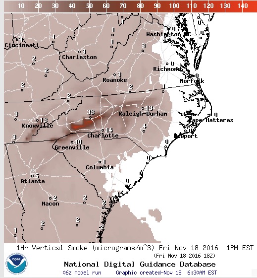
Most of the eastern one-third of the United States will be experiencing some degree of wildfire smoke on Friday. But by far the heaviest concentrations are being created by the wildfires in the South. The winds on Friday will cause the much of the smoke to pass through areas in western Tennessee, northern Georgia, and western North Carolina.

Forecast for wildfire smoke at 1 p.m. ET November 18, 2016, created at 6:30 a.m. ET November 18, 2016.

Continue reading “North Carolina to receive the worst of the smoke on Friday”

Update on six wildfires in the South, November 16, 2016

Above: The map shows the locations of some of the larger wildfires currently burning in Tennessee, South Carolina, North Carolina, and Georgia.

Firefighters continue to battle dozens of fires in the southern United States while the residents in the area try to figure out how to live with the smoke.

Fire managers are hoping for a break in the weeks-long dry period, but through Friday at least they should expect more of the same. However there is a chance for rain on Saturday.

Here we will look at six of the larger fires in Georgia, North Carolina, and South Carolina.

Party Rock Fire

map Party Rock Fire
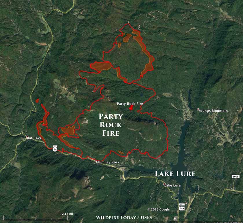
Perimeter of the Party Rock Fire in North Carolina, 3 a.m. ET November 16, 2016.

The Party Rock Fire has been burning just north of Lake Lure, North Carolina since November 5. It has blackened 4,480 acres, an increase of 736 acres, and forced evacuations at Bat Cave and residences on the east side of Hwy 9. In recent days it has been most active on the north and southwest sides.

Rock Mountain Fire

map Rock Mountain Fire Boteler Fire
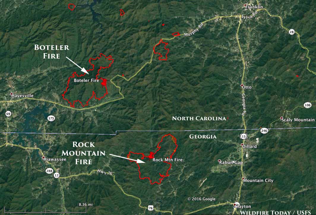
Perimeters of the Boteler Fire in NC at 11:45 p.m. ET November 15, 2016, and the Rock Mountain Fire in GA at 2 a.m. ET November 16, 2016.

The Rock Mountain Fire has burned 6,747 acres in the northeast corner of Georgia, an increase of 1,263 acres over the previous 24 hours primarily on the northeast and west sides. The Type 1 Incident Management Team reports that 75 structures are threatened, but none have been destroyed.

Continue reading “Update on six wildfires in the South, November 16, 2016”

Wildfire smoke forecast for Tuesday, November 15

Above: Smoke from wildfires in the southern United States as photographed by a NASA satellite Tuesday afternoon, November 15, 2016; updated late Tuesday afternoon.

We checked several resources for predictions of where smoke from the wildfires in Tennessee, North Carolina, South Carolina, and Georgia will be distributed on Tuesday. It looks like much of Georgia and South Carolina will be heavily affected, with concentrations in some areas of South Carolina reaching the “Very Unhealthy” level according to the animated map below.

Some areas in the midwest appear to be affected by smoke that blew in from fires in Canada.

Arkansas, Louisiana, and eastern Texas are also heavily contributing to the smoky skies.

Check AirNow.gov for current air quality information. Click on their map to zoom in for a closer look.

An air quality index of 201 to 300 is “Very Unhealthy”.

Continue reading “Wildfire smoke forecast for Tuesday, November 15”

Wildfire smoke causes air quality to worsen in TN, SC, and NC

Above: Smoke from wildfires as photographed by a NASA satellite November 13, 2015. 

The wildfires in the southeast continue to produce large quantities of smoke that in recent days has not been migrating out of the area very quickly. The AirNow.gov forecast for air quality predicts “Unhealthy” conditions Monday and Tuesday in Asheville, NC valleys and Hickory, NC.

smoke, air quality,
AirNow.gov shows degraded air quality near wildfires in the southeast.

The smoke forecast from NOAA’s Earth System Research Laboratory for 11 p.m. ET on Monday shows intensifying smoke in eastern Georgia and the western portions of North Carolina and South Carolina.

wildfire smoke forecast
Wildfire smoke forecast for 11 p.m. ET November 14, 2016. Prepared 1 p.m. ET November 14, 2016. It shows smoke intensifying in eastern Georgia and the western portions of North Carolina and South Carolina. NOAA’s Earth System Research Laboratory.

*

For the latest articles at Wildfire Today about wildfire smoke check out the articles tagged “smoke”.

Information and maps of five wildfires in Georgia and North Carolina, Nov. 14, 2016

Above: The map shows the location of some of the larger wildfires currently burning in Georgia, North Carolina, South Carolina, and Tennessee.

There are still dozens of wildfires burning in the southern United States, primarily in Georgia, North Carolina, South Carolina, and Tennessee. Firefighters have slowed the progress of many of them but others are still spreading. The weather on Sunday was not quite as conducive to extreme fire behavior, but most areas are still extremely dry and have not had significant precipitation in weeks.

The weather forecast for the Asheville, NC area through Saturday, November 12, calls for more of the same weather — moderate winds, daily high temperatures in the 60s, and relative humidities in the 80s at night and the 30s in the afternoon.

Below are some statistics for the active fires in the Southern Geographic Area:

  • 73 active fires
  • 109,563 cumulative acres
  • 103 hand crews assigned
  • 242 engines
  • 19 helicopters
  • 3,492 personnel

Here is a look at five of the more active blazes:

Party Rock Fire

map party rock fire
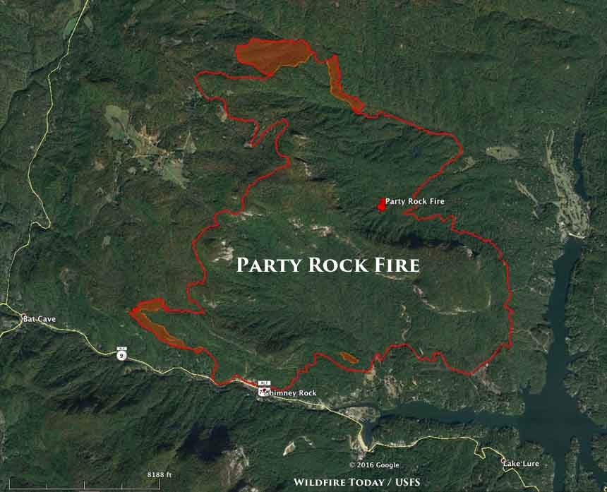
Map of the perimeter of the Party Rock Fire at 11 p.m. ET November 13, 2016.

The Party Rock Fire has been burning just north of Lake Lure, North Carolina since November 5. It has blackened 3,457 acres and required evacuations in the Chimney Rock community. On Saturday and Sunday it grew by 574 acres, with most of the additional acres being on the southwest and northwest sides.

Tellico Fire

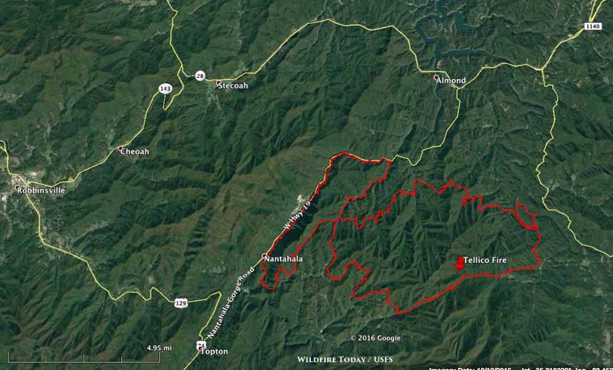
map Tellico Fire
Map of the perimeter of the Tellico Fire at 11 p.m. ET November 13, 2016.

The Tellico Fire three miles south of Almond, North Carolina expanded by 3,791 acres over the weekend and now stretches across 13,676 acres after merging with another fire, the Ferebee Fire. It spotted across the Little Tennessee River to the east, but that spot was contained at about 100 acres. U.S. Highway 19 on the west side of the fire was closed on Sunday.

Continue reading “Information and maps of five wildfires in Georgia and North Carolina, Nov. 14, 2016”