12:15 p.m. MDT July 3, 2021

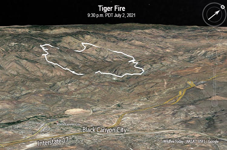
The Tiger Fire three miles northwest of Black Canyon City, Arizona was very active Friday night. In the six hours after it was mapped at 9:30 p.m. it ran north for almost two miles, according to data collected by a satellite at 4:04 a.m. Saturday (see map above). It was burning aggressively in the footprint of the 4,900-acre Rattlesnake Fire of 2015.
Early Saturday morning the Tiger Fire was about 2 miles west of Interstate 17 and 5 miles southeast of Crown King. At 9:30 p.m. Friday it had burned 5,567 acres, but the later additional spread could have added more than 1,000 acres.

The lightning-caused fire was reported at 2 p.m. on June 30.
Resources assigned to the fire Friday evening June 2, included 2 hand crews, no fire engines, and 2 helicopters for a total of 63 personnel.
Firefighters are scouting the west side to plan locations for potential fire lines to control the growth. On the east side they are identifying old mines and other hazards and looking at values of risk for future structure protection.
Due to severe drought the vegetation, or fuels, are dry or dead which can accelerate the spread of the fire.
In a Saturday morning update the Incident Management Team said, “Access into the Castle Creek Wilderness is limited by the steep terrain making it unsafe for firefighters to fight the fire directly at the edge. The incident management team is being strategic on the placement of firefighting resources to ensure safe ingress/egress. Protection of life is the highest priority.”

