Bushfire east of Melbourne in Bunyip State Park doubles in size

The fire has grown to over 30,600 acres (12,400 HA)

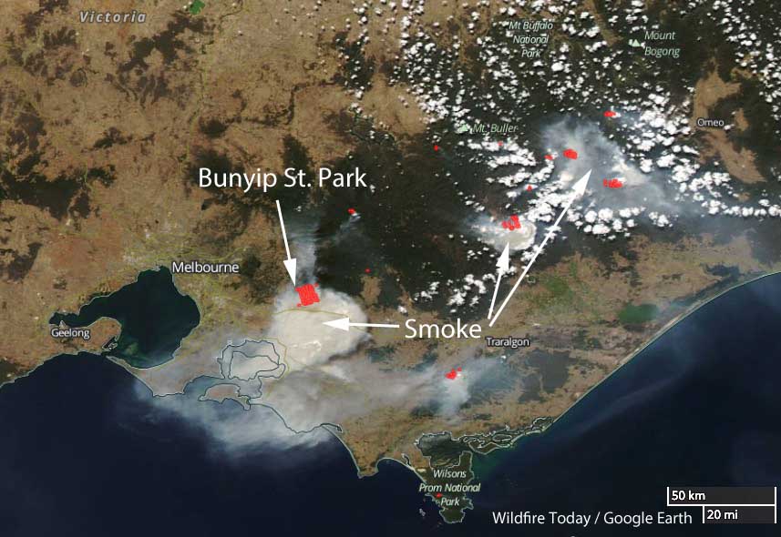
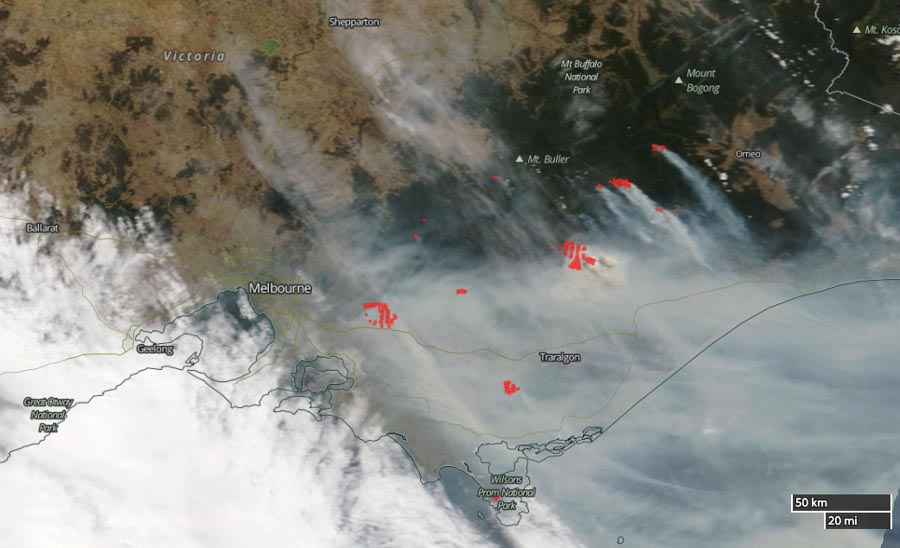
satellite photo map bushfire east of Melbourne, Victoria
The satellite photo shows smoke created by the bushfires east of Melbourne, Victoria, Australia, March 3, 2019. The red dots represent heat. The white areas south and west of Melbourne are clouds. To the east is smoke.

The large bushfire about 65km east of Melbourne, Victoria, Australia has doubled in size during the last 24 hours. It is a result of four fires in Bunyip State Park merging and has now blackened about 12,400 HA (30,600 acres).

Emergency Management Victoria has downgraded the incident from an emergency alert to a Watch and Act that affects the following areas: Basan Corner, Beenak, Bunyip, Bunyip North, Cornucopia, Garfield, Garfield North, Gentle Annie, Labertouche, Longwarry North, Maryknoll, Nar Nar Goon, Tonimbuk, Tynong, Tynong North.

On Saturday and Sunday the wind direction changed several times pushing the fire in a variety of directions. This can be very dangerous for firefighters.
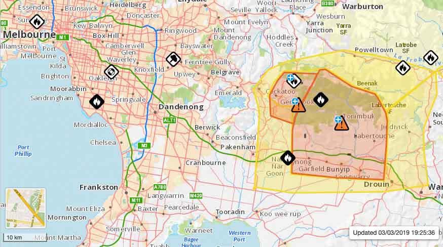
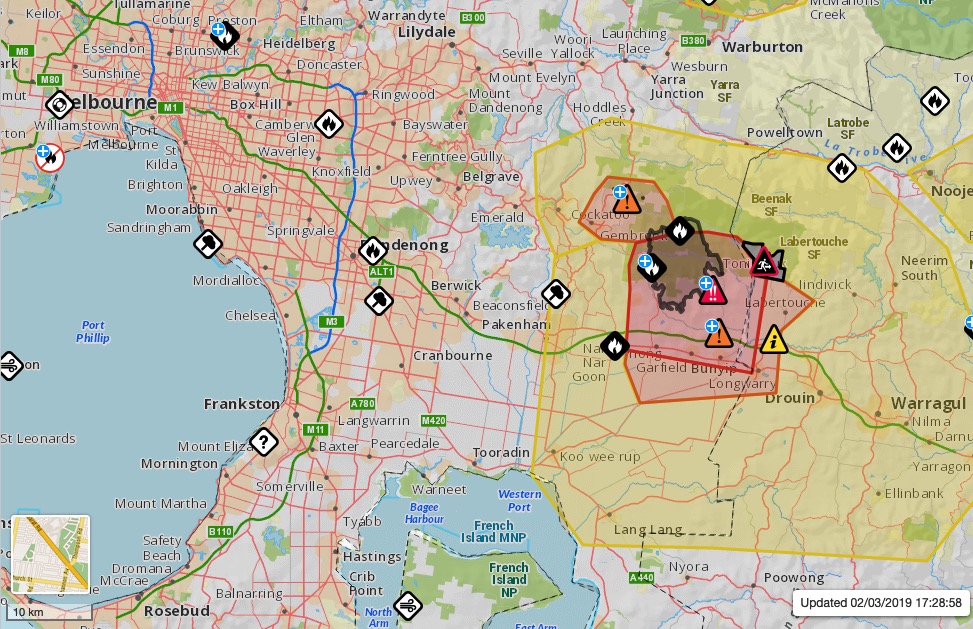
map bushfire east of Melbourne, Victoria
Map showing the location of the bushfire east of Melbourne, Victoria.

The video below at 1:30 captured Air Tanker 137, a Boeing 737, making a retardant drop.

Hot, dry, windy conditions spread wildfires east of Melbourne, Australia

A blaze in Bunyip State Park has burned over 15,000 acres

Wildfires in Victoria
Wildfires in Victoria east of Melbourne, March 3, 2019 local time. The red dots represent heat detected by a satellite.

The weather in Victoria, Australia is causing multiple wildfires to spread rapidly endangering residents in some areas east of Melbourne. Presently there are 25 fires burning in the state. Fifteen of them are in eastern Victoria.

Four fires near Bunyip State Park, near Tonumbik, about 65km east of Melbourne, merged on Saturday into one blaze that has burned 6,280 hectares (15,500 acres) as of Sunday afternoon local time.

map wildfire Bunyip State Park in Victoria, Australia
Map showing the location of the wildfire in Bunyip State Park in Victoria, Australia. Vic Emergency map.

Officials warn that the fire in the state park is expected, after a wind shift, to move closer to Labertouche North and warned residents to be prepared to evacuate. Three homes have been destroyed in the fire so far.

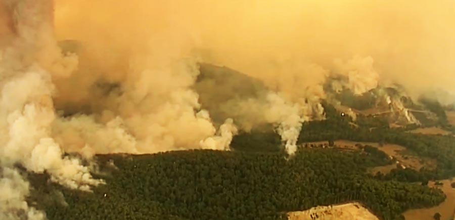
Wildfire in Bunrip State Park
Wildfire in Bunyip State Park. Screengrab from 7 News Melbourne video.

At least one night-flying helicopter dropped water on the fire Saturday night until 3 a.m. local time. About 850 people, 120 fire trucks, and 20 aircraft will be working on the state park blaze Sunday.

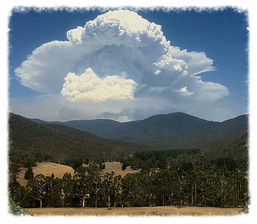
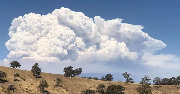
Pyrocumulus cloud near Timbarra, Victoria

Pyrocumulus Australia wildfire bushfire
Pyrocumulus north of Timbarra, Victoria, Australia. Murray King took the photo 30km west of the fire in Bindi, East Gippsland on January 25, 2019 at 5:30 p.m.

Murry King sent us this photo of the pyrocumulus cloud over a bushfire north of Timbarra, Victoria, Australia. He got the shot from a point 30km west of the fire in Bindi, East Gippsland on January 25, 2019 at 5:30 p.m.

Thanks Murry.

Here is the latest information about the fire from Vic Emergency:

This Advice message is being issued for Timbarra, Gillingall, Gelantipy, Butchers Ridge, W-Tree, Murrindal, Buchan and Buchan South.

There is an active bushfire north of Timbarra and Gillingall and west of the Gelantipy Road between Butchers Ridge and W-Tree that is not yet under control.

We have now started igniting a back burn on the south eastern corner of the fire near W-Tree, along Hodges Track and Dawson Track. If conditions are favourable, we will continue to extend the back burn later today.

There will be increased smoke in this area. Crews and machinery continue to strengthen containment lines around the fire perimeter.

Here is another photo of the pyrocumulus taken around the same time.

Massive pyrocumulus cloud over Australian bushfire produces hundreds of lightning strikes

Timbarra bushfire
Massive pyrocumulus cloud over a bushfire north of Timbarra, Victoria, Australia. TRFM photo.

Extreme heat on Friday in Victoria, Australia combined with strong winds and low humidity caused a bushfire 10 km (6 miles) north of Timbarra to grow from 300 hectares (740 acres) to approximately 10,522 hectares (26,000 acres). Lighting ignited the fire on January 16 and in an odd twist, extreme fire behavior Friday created hundreds of lightning strikes around a massive pyrocumulus cloud that rose to 38,000 feet while igniting additional fires.

The temperature at the top of the cloud was -55°C (-67°F) according to the Victoria Bureau of Meteorology.

Friday evening the weather changed substantially, bringing in cool, moist air that slowed the spread of the fire. Officials say due to the size and difficult topography, it will be weeks before it can be completely contained.

A success story at Tarrawingee

Victoria Bushfire
Screenshot from video by Tarrawingee Rural Fire Brigade.

Quick work by firefighters in Victoria, Australia drew praise from the daughter of a landowner whose property was burning near Tarrawingee northeast of Melbourne.

The Country Fire Authority reported that firefighters from Eldorado, Everton, Springhurst, Tarrawingee, Wangaratta, and Wangaratt North responded to the fire on the Tarrawingee-Eldorado Road at around midday on Saturday December 1. The fire was brought under control by 12:25 P.M.

Posting on Facebook, Brooke Sheppard Ross said: “For one hour these selfless people assisted by DSE and Forestry members battled the dry grass and intermittent wind that fanned the flames into our bush land paddocks.”

From The Guardian on November 28:

While parts of the drought-stricken eastern [Australian] states have enjoyed some recent rain and there have been huge downpours along the NSW coast during this week’s storms, experts are warning it won’t be long before the hot summer temperatures dry out ground vegetation.

“Above-normal fire potential remains across large parts of southern Australia,” the Bushfire and Natural Hazards Cooperative Research Centre said in its seasonal bushfire outlook, also released on Thursday.

As part of its summer outlook, the Bureau of Meteorology has forecast a drier-than-average summer for large parts of Queensland, Western Australia and the Northern Territory.

“Having said that, locally heavy rainfall events similar to what we have seen in NSW in the last two days are always a possibility during summer, no matter what the outlook is showing,” Watkins said.

NSW has recorded its eighth driest and fourth hottest April-November on record, with Queensland and Victoria having experienced similar conditions.