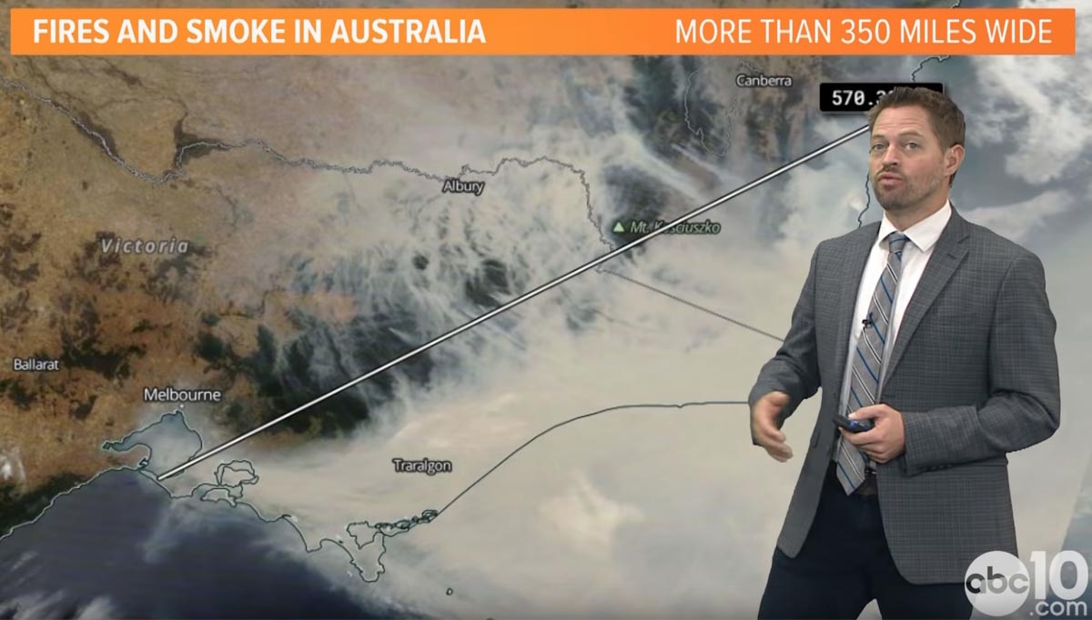
Rob Carlmark, a meteorologist at Sacramento TV station ABC10, explains the weather that has created the current unprecedented bushfire situation in Australia.
You can follow Mr. Carlmark on Twitter: @rcalrmark

Rob Carlmark, a meteorologist at Sacramento TV station ABC10, explains the weather that has created the current unprecedented bushfire situation in Australia.
You can follow Mr. Carlmark on Twitter: @rcalrmark
Temperatures in the New South Wales inland areas on Friday will be over 100F accompanied by strong winds
Continue readingThat may be what causes allergic reactions in some people who are sensitive to smoke
Continue reading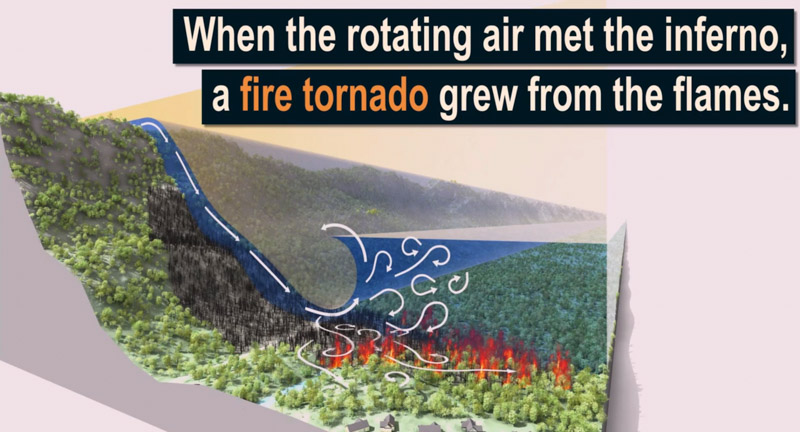
Scientific American has produced a video that describes the formation of the fire tornado that burned and scoured a mile-long path as the Carr Fire burned into Redding, California July 26, 2018.
In the video below, click on the little square at bottom-right to see it in full screen.
There were two fatalities on the Carr Fire that day. Redding Fire Department Inspector Jeremy Stoke was burned over in his truck on Buenaventura Boulevard. On the other side of the Sacramento River, on the west side, Don Ray Smith was entrapped and killed in his dozer.
According to a Green Sheet report by CAL FIRE, the conditions that resulted in the entrapment of three dozers and the Redding Fire Department Fire Inspector that day were due to the fire tornado — a large rotating fire plume that was roughly 1,000 feet in diameter. The winds at the base were 136-165 mph (EF-3 tornado strength), as indicated by wind damage to large oak trees, scouring of the ground surface, damage to roofs of houses, and lofting of large steel power line support towers, vehicles, and a steel marine shipping container. Multiple fire vehicles had their windows blown out and their bodies damaged by flying debris.
The strong winds caused the fire to burn all live vegetation less than 1 inch in diameter. Peak temperatures likely exceeded 2,700 °F.
The Carr Fire burned 229,651 acres, destroyed 1,077 homes, and killed 3 firefighters and 5 civilians
The news media sometimes calls any little fire whirl a “fire tornado”, or even a “firenado”. These and related terms (except for “firenado”) were, if not founded, at least documented and defined in 1978 by a researcher for the National Weather Service in Missoula, David W. Goens. He grouped fire whirls into four classes:
Thanks and a tip of the hat go out to Rick. Typos or errors, report them HERE.
Nine weather stations in San Diego County recorded more than 4 inches of precipitation
Continue readingThe Energy Release Component is at or above record levels in some areas of the state
Continue readingIt will remain high in southern California through December
Continue readingUPDATED at 7:38 a.m. PDT November 1, 2019

The weather in southern California will be dry and breezy on Friday and Saturday but not to the extreme levels seen earlier this week. There are no Red Flag Warnings, but in Santa Clarita where the Tick Fire occurred for example, the forecast calls for 10 to 14 mph northeast winds gusting at 16 to 29 off and on into Friday night. Through Saturday the relative humidity will remain below 10 percent during the day with no recovery at night.
The Hot-Dry-Windy Index will be above the 75th percentile on Friday and Saturday.
Friday morning the chart below was revised to add the red “Critical” area that was not in the version issued Thursday. That is where the Maria Fire started at 6:15 p.m. Thursday east of Ventura, California.


There are no Red Flag Warnings in the medium-range weather outlook for southern California, but it is supposed to be dry.
Good News: 12Z models do not indicate any significant chances of #SantaAnaWinds next 10-15 days.
Bad News: deterministic GFS and ECMWF dry the next 10-15 days for #SoCal. Even the GFS ensemble only has 2-3 members indicating any light rain.
— Rich Thompson (@RichIMET) October 31, 2019
Barry Myers is the former CEO of Accuweather
Continue reading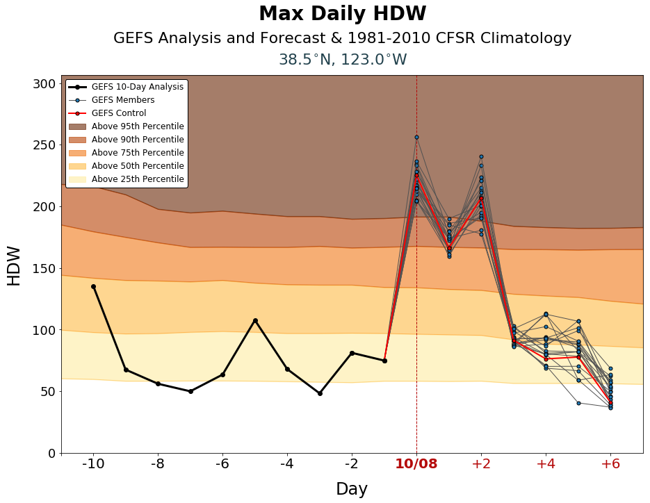
Weather forecasters expect the wildland fire danger in some areas of California to be extreme Tuesday night and into Thursday. Strong north to northeast winds accompanied by low humidity has triggered Red Flag Warnings putting land managers on edge. PG&E is so worried it is proactively turning off the electrical power to 600,000 addresses in nearly 30 northern, central, coastal, and Bay Area counties.
We consulted a fairly new fire danger forecasting tool to see how it analyzed what firefighters will be faced with for the next few days. The Hot-Dry-Windy Index (HDW) is described as being very simple and only considers the atmospheric factors of heat, moisture, and wind. To be more precise, it is a multiplication of the maximum wind speed and maximum vapor pressure deficit (VPD) in the lowest 50 or so millibars in the atmosphere.
The products, displayed as charts, show the index for the preceding 10 days and the forecast for the next 7 days. For the current and following days you will see results of the Global Ensemble Forecast System (GEFS), which is a weather forecast model made up of 21 separate forecasts, one control (in red) and twenty perturbations. The reasoning for showing 21 different forecasts is to quantify the amount of uncertainty in a forecast by generating an ensemble of multiple forecasts, each minutely different, or perturbed, from the original observations.The HDW only only uses weather information – fuels and topography are not considered by HDW at all. If the fuels are wet or have a high live or dead moisture content it will not be reflected in the data.
At the top of the page is the HDW forecast for an area about 15 miles northwest of Santa Rosa in the Bay Area of California. It predicts the Index will be above the 95th percentile on October 8, above the 90th percentile on October 9, and back up to the 95th percentile on October 10.
Below are HDW predictions for other areas in California.


