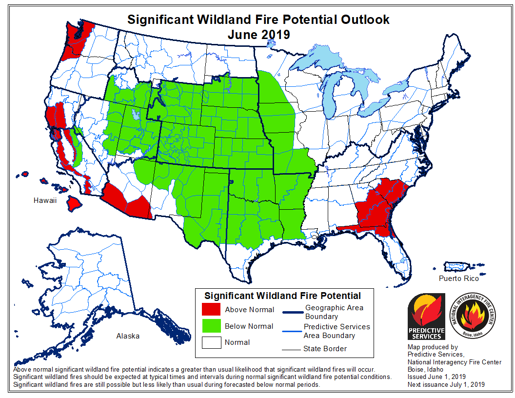
Forecasters predict the potential for large wildfires will be higher than average on the west coast this summer

Areas to watch will be Northern California and the west sides of Oregon and Washington

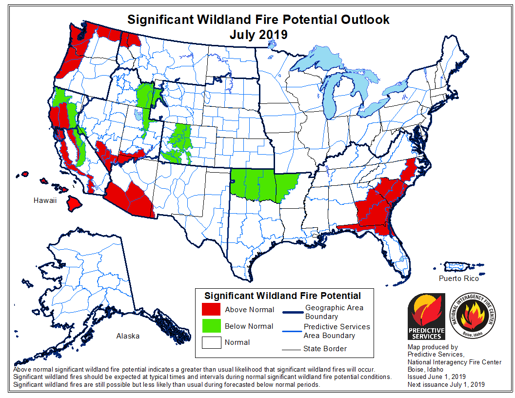
June wildfire potential

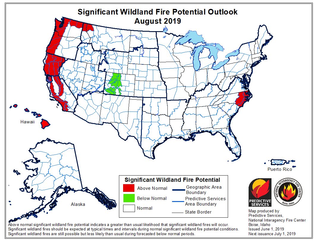
On June 1 the Predictive Services section at the National Interagency Fire Center issued their Wildland Fire Potential Outlook for June through September. The data represents the cumulative forecasts of the ten Geographic Area Predictive Services Units and the National Predictive Services Unit.

If NIFC’s analysis is correct, the areas with above normal wildfire potential on the western sides of Washington, Oregon, and California will expand during the four-month period until they cover most of the forested lands in California as well as northern Washington and Idaho. Forecasters predict portions of Florida, Georgia, and the Carolinas will have enhanced potential in June and July.

The areas affected by  the multi-year drought in the West have greatly decreased to the point where there are no locations with extreme or exceptional drought. Northwestern Oregon is classified as “severe drought” and this could be an area to watch over the summer months.

Below:

  • An excerpt from the NIFC narrative report for the next several months;
  • More of NIFC’s monthly graphical outlooks;
  • NOAA’s three-month temperature and precipitation forecasts; and,
  • Drought Monitor.
  • Vegetation greenness maps

From NIFC:
“…As June progresses, the fine fuels will begin to cure and dry from south to north across the West. Lingering high elevation snowpack should be lost. Wildfire activity should begin to increase by late month as peak of the fire season begins to arrive as July and August approach. As is the case with the lower elevation fuels, the high elevation heavy fuels will also experience a delayed entry into the season except along the Canadian Border in Washington State where overall dryness will lead to an average start with a potential for above normal activity. Alaska will reach its peak in June and begin to wind down in July.

“Looking ahead to August and September the fire potential and resulting activity should increase to Normal in most areas except along the West Coast where Above Normal significant large fire potential is expected due to fuel loading and preexisting dry conditions. A traditional winding down of the Western fire season is expected in Mid-September as fall moisture begins to arrive…”

July wildfire potential

August wildfire potential

Continue reading “Forecasters predict the potential for large wildfires will be higher than average on the west coast this summer”

Map showing 10 days of precipitation helps explain widespread flooding

Cumulative precipitation 10-day period
Cumulative precipitation over the 10-day period ending Mary 29. NWS data processed by Wildfire Today. Click to enlarge.

This map showing cumulative precipitation over the 10-day period ending May 29 helps explain some of the recent widespread flooding in the middle of the country. It looks like a few areas had more than 12 inches. Many locations had more than 6.

(I don’t know why data for those five western states does not show up.)

A couple of highlights from Matt Jolly’s fire weather presentation

fire danger firefighter entrapments
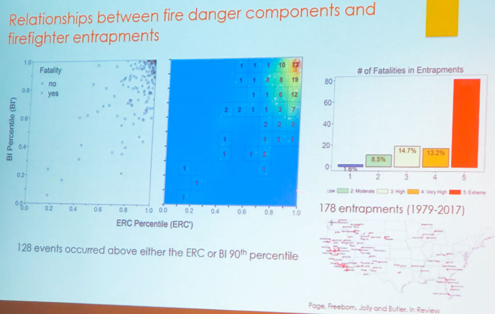
Association between weather and firefighter entrapments. From Matt Jolly presentation, May 2, 2019. Click to enlarge.

At the International Association of Wildland Fire’s Fuels conference currently underway in Albuquerque, Research Ecologist Matt Jolly’s presentation on “Mapping extreme fire weather and its impact on firefighter safety” was very interesting. In his allotted 20 minutes he began by talking about the rollout that is nearly complete of the third revision of the National Fire Danger Rating System.

Mr. Jolly described the development and evaluation of an extreme fire weather metric called the Severe Fire Weather Potential Index. The Index is strongly correlated to wildland fire occurrence and intensity detected by the MODIS satellite and is a strong predictor of wildland firefighter entrapments and fatalities from 1979 to 2017.

wildfiresafe app
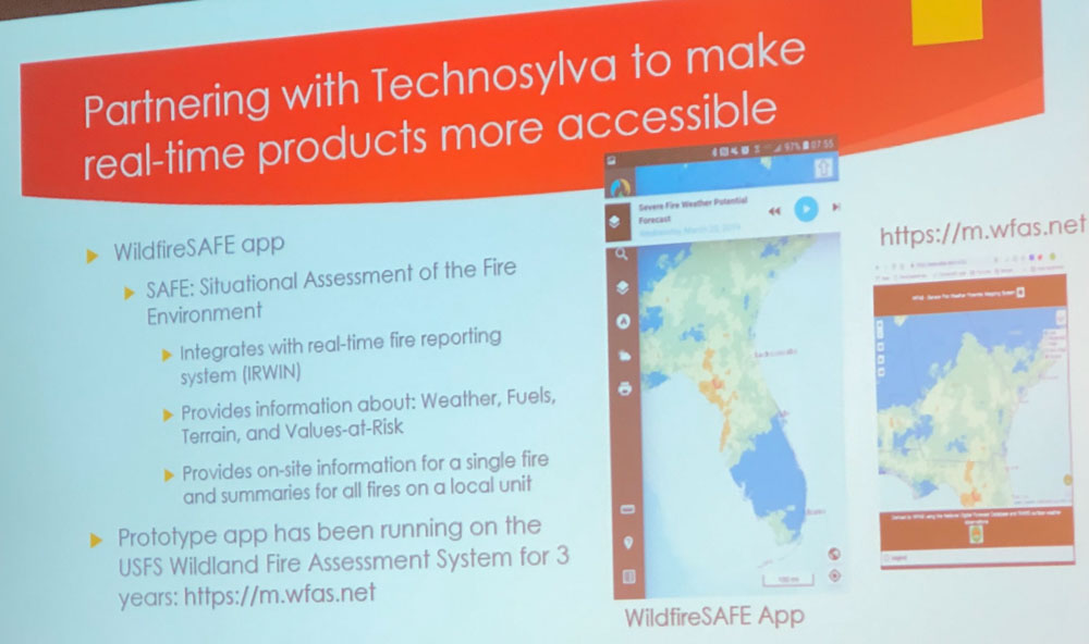
WildfireSafe app. From Matt Jolly presentation, May 2, 2019.

Mr. Jolly said some firefighters have told him that the WildfireSafe app which has been in the prototype stage for the last three years is a useful tool for accurately predicting the fire danger at the local level.

These images were snapped with a cell phone during Mr. Jolly’s presentation.

Wildfire potential, May through August

If NIFC’s analysis is correct, wildfire activity along the west coast will grow substantially into the summer

wildfire potential

On May 1 the Predictive Services section at the National Interagency Fire Center issued their Wildland Fire Potential Outlook for May through August. The data represents the cumulative forecasts of the ten Geographic Area Predictive Services Units and the National Predictive Services Unit.

If NIFC’s analysis is correct, the wildfire potential in areas along the west coast will grow substantially into the summer.

The multi-year drought in California has been virtually neutralized due to substantial quantities of winter rain and snow. An area to watch will be the west sides of Oregon and Washington.

Below:

  • An excerpt from the NIFC narrative report for the next several months;
  • More of NIFC’s monthly graphical outlooks;
  • NOAA’s three-month temperature and precipitation forecasts; and,
  • Drought Monitor.

“Greenup is occurring across the nation entering May; fuels across the Southwest are now drying and curing and will become increasingly receptive to fire activity as the month progresses. Looking north, Alaska’s interior is becoming drier and increasing activity is expected. By late May and early June, California and the southern Great Basin will see an increase in activity as fine fuels dry and cure. In July, low and middle elevation fine fuels will dry across the remainder of the West and will gradually become receptive to fire activity from south to north. Unlike most years, there could be a delayed start to the season in the higher, timbered elevations due to preexisting weather conditions and slower than average snowpack melting rates. An exception to this could be along the Canadian Border with Washington, Idaho, and western Montana where below average snowpack and moderate drought conditions exist. These areas can expect an average start to the season with a potential for above normal activity. A normal transition out of fire season is expected across Alaska in July. The onset of the southwestern monsoon may be slightly delayed.

“August marks the beginning of the peak of the western fire season. Most of the country can expect Normal conditions. Exceptions will be along the West Coast. A heavy crop of grasses and fine fuels has developed across California and should elevate the potential as it cures and dries. Higher elevations in the Sierra will likely see a late entry into the season due to the record-setting snowpack and slow meltoff. The Pacific Northwest has entered a period of moderate drought. An early entry is possible across the Cascades and in the Okanogan. Elsewhere, some high elevations across the Great Basin and central Rockies could experience Below Normal potential and conditions.”

wildfire potential

Continue reading “Wildfire potential, May through August”

NWS develops system for quickly notifying land managers when satellites detect wildfires

The NWS may one day issue watches and warnings based on the predicted spread of a dangerous wildfire.

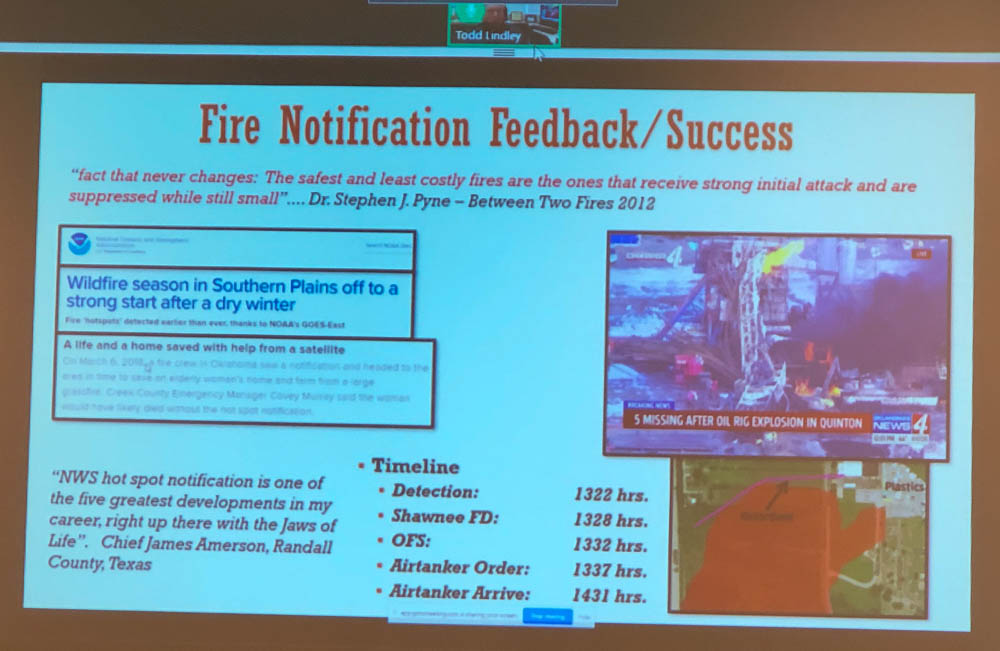
The higher resolution and shorter time intervals between images on the more recently launched weather satellites has made it a reality for wildfires to be detected and local land managers notified within minutes.

The new GOES 16 and GOES 17 satellites can identify new wildfire ignitions more accurately than their predecessors. The higher resolution means the location can sometimes be pinned down to within less than a miles as long as the temperature reaches the threshold that triggers the software to paint it in the image.

For a while the National Weather Service had occasionally notified land managers when they detected a wildfire but in 2016 as numerous blazes erupted in Oklahoma and Kansas the Oklahoma Forestry Services Fire Management Chief specifically asked for help to identify new fire starts. In an April 30, 2019 presentation  transmitted remotely to the International Association of Wildland Fire’s Fire Behavior and Fuels Conference in Albuquerque, T. Todd Lindley, Science and Operations Officer with the NWS, said that considering the fire storms brewing in the area on that day in 2016 that someone on their staff determined that, “We need to innovate today”.

detect wildfires satellite notify fire department
Cell phone photo of a slide from T. Todd Lindley’s remotely transmitted presentation April 30, 2019.

Within about four hours, Mr. Lindley said, they had developed a computer program that could enable a forecaster to send a notification to a land manager about a new fire very quickly, with just a few mouse clicks.

They have had success with the system, with 83 percent of notifications being received prior to local 911 calls.

And branching off of their ability to predict the tracks of thunderstorms and tornados and issuing watches and warnings, the NWS is experimenting with identifying the projected spread of a fire which could possibly lead to issuing watch and warning areas for wildfires.

Analysis of how precipitation affects wildfire occurrence

analysis precipitation wildfires

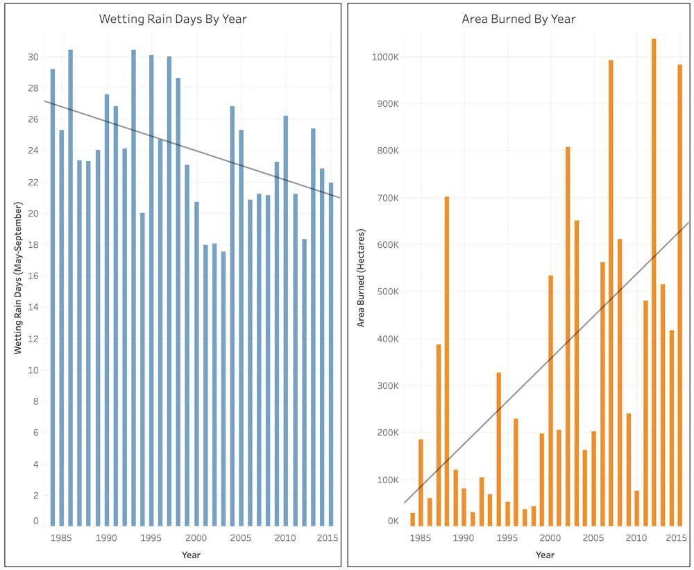
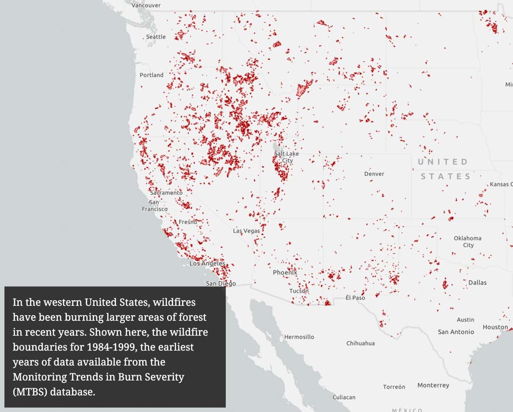
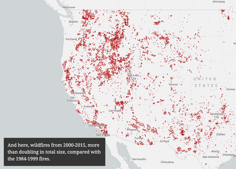
Researchers have developed a fancy graphic presentation that explores the relationship between precipitation and the annual area burned in the Western United States. You should check it out.

They concluded that weather conditions DURING the fire season, humidity and rain, have far more effect on total acres burned than winter snow.

The figures and text (below) here are excerpts from the document.


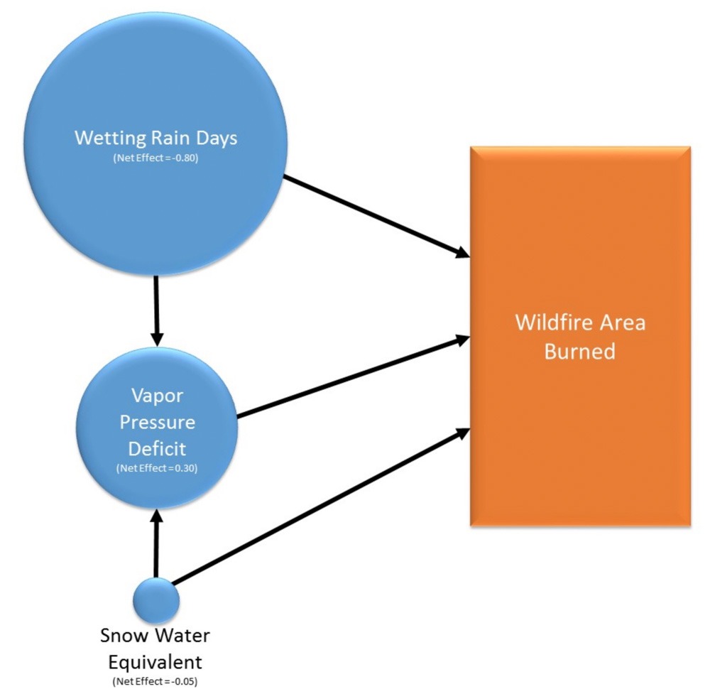
“Wildfires have been increasing: but why? Is it the effect of increasing temperatures? Declining snowpack? Decreasing precipitation? In their recent paper, “Decreasing fire season precipitation increased recent western US forest wildfire activity,” Zachary Holden and his co-authors explore the relative influence of these factors. They first identified the variables related to temperature, snow, and precipitation that best predicted area burned:

“Temperature: vapor pressure deficit [VPD] (the difference between the maximum amount of water the air can hold and the amount it actually holds)

“Snow: maximum annual snow water equivalent [SWE], and

“Precipitation: wetting rain days [WRD], days with more than 1/10 inch of rain, in the months of May through September.”

analysis precipitation wildfires

analysis precipitation wildfires

analysis precipitation wildfires