Outlook for wildfire potential, September through December, 2015

The Predictive Services section at the National Interagency Fire Center has issued their Wildland Fire Potential Outlook for September through December, 2015. The data represents the cumulative forecasts of the ten Geographic Area Predictive Services Units and the National Predictive Services Unit.

If their forecasts are accurate, above normal wildfire potential will continue in the Northwest and southern California through September, but beginning in October it will exist only in southern California, and temporarily in a portion of central Texas.

Here are the highlights from their outlook.

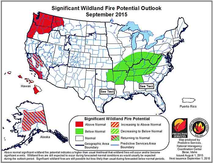
September

September wildfire outlook

  • Significant fire potential will remain above normal across much of Washington, northeastern Oregon, northern Idaho and northwestern Montana.
  • Above normal significant fire potential will continue across the mountains of southern California.
  • Below normal fire potential will occur over the Mid-Mississippi and Ohio Valleys and most of Florida.

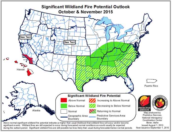
October

Ocdtober wildfire outlook

  • The southern California coastal region will remain in above normal fire potential while the central coast and the Sierras return to normal fire potential.
  • Below normal fire potential will spread across the Ohio, Tennessee and Mid-Mississippi Valleys.

November through December

November wildfire outlook

  • Southern California will return to normal in November.
  • Below normal fire potential will spread over the coastal states from Texas to North Carolina.

Dangerous dry thunderstorms reign in Pacific Northwest

Posted on Categories UncategorizedTags
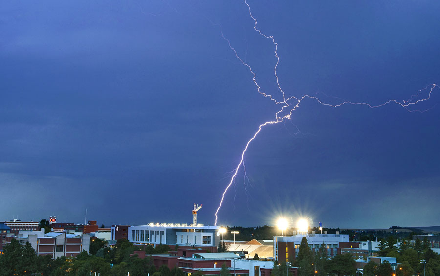
Lightning over Washington State University
Lightning seen from Washington State University, Pullman campus. Photo by Shelly Hanks, WSU Photo Services.

PULLMAN, Wash. – Major firestorms burning in parts of the Pacific Northwest are the result of angry skies pitching lightning bolts to the ground when little or no rain is falling. The fast-moving blazes are destroying homes, closing roads and triggering smoke advisories miles away. Where is the lightning coming from and where is the rain?

In a bad-weather phenomena sometimes referred to as dry lightning or dry thunderstorms, the atmosphere  has been so hot and dry that rain produced in a cloud evaporates before it reaches the ground, according to an atmospheric scientist at Washington State University.

This vanishing rain – called virga – can appear as soft streaks exiting the bottom of clouds. While most of the virga never makes it to the ground, the lightning generated in the cloud still does, said professor Brian Lamb, who teaches a course in meteorology and runs the university’s Laboratory for Atmospheric Research.

When a downward spear of lightning sparks even a small flame on parched landscape, “there’s no accompanying rain to extinguish it,” he explained. “With the drought turning timber, brush and grass bone-dry, there’s ample fuel to feed the flames.”

Hazardous fire weather

In north central Idaho, multiple lightning strikes in a single night last week caused a still-raging complex of fires near Kamiah, wiping out more than 30 homes and prompting highway driving restrictions and smoke advisories in communities 100 miles away.

In Washington state, a 15-mile stretch of fire consuming timber and brush and threatening the town of Chelan was started by five small lightning fires that merged over the weekend, according to fire incident reports. Near Mount Adams, Washington’s National Guard has been mobilized to assist in fighting a wildfire that quickly ballooned to 22,000 acres after it was sparked by lightning one week ago, according to the Northwest Interagency Coordination Center.

Fueling the problem is that dry lightning storms are sometimes accompanied by microbursts, said Lamb. These are drafts of cold air pushed downward from a cloud that hit the ground and spread outward as gusts of wind.

“When lightning hits the ground and sparks a fire, a gust of wind can push the fire’s margins very quickly,” he explained.

Where’s the thunder?

If rain doesn’t reach the ground during a dry thunderstorm, does that mean there’s no thunder as well?

There is thunder, said Lamb, even though people might not hear it: “Thunder is a result of lightning. If you see lightning but don’t hear thunder, it’s because the storm cloud is too far away.”

Stunning video of a thunderstorm downburst

Often, downbursts or downdrafts coming out of a thunderstorm are invisible, especially if it is a dry downburst. This weather phenomenon in the dissipating stage of a thunderstorm can be deadly if the wind direction suddenly changes and affects the direction of spread of a wildfire.

The video above is of a wet downburst. That and the time lapse feature make it possible to clearly see the air and the rain descending, reaching the ground, and then spreading out. Firefighters need to be aware that this is not a rare occurrence and it can affect the wind direction miles away from the cloud.

Wikipedia has more information about downbursts.

Outlook for wildfire potential, August through November, 2015

The Predictive Services section at the National Interagency Fire Center has issued their Wildland Fire Potential Outlook for August through November, 2015. The data represents the cumulative forecasts of the ten Geographic Area Predictive Services Units and the National Predictive Services Unit.

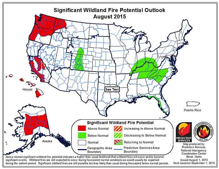
If their forecasts are accurate, portions of Idaho, Washington, Oregon, California, Alaska, and Montana will have above normal wildfire activity through September.

It is interesting that northern California, where many fires are growing at very, very rapid rates, has “normal” wildfire potential according to the analysis for August, perhaps because of this statement in the document about northern California:

The strengthening El Niño pattern will cause occasional monsoon surges, mainly in August.

Here are the highlights from their outlook.

****

August

wildfire potential August

  • Drier than normal fuels and little forecasted relief have led to above normal significant fire potential for most of the Northwest and western
    portions of the Northern Rockies.
  • Long term drought will keep significant fire potential above normal in Southern California.
  • Alaska will see continued periodic acreage growth from established fires which will lead to overall above normal significant fire potential.
  • Elsewhere mostly normal activity should be expected; which includes frequent significantfires and plentiful initial attack for August.

September

wildfire potential September

  • Central California and Alaska will see significant fire potential return to normal; however dry conditions are expected to persist in the Northwest, western Northern Rockies and far Southern California. 
  • Elsewhere primarily normal activity should be prevalent. For September, this means a rapid decline in both numbers of fires and acres burned for most Areas.

October-November

wildfire potential October November

  • Far Southern California will remain above normal for October and November; while most of the rest of the U.S. will be normal in many areas indicating little or no fire activity.
  • Below normal significant fire potential across most of the eastern U.S. for this period thanks to frequent moisture inputs represents a reduced fall and winter fire season for U.S. overall.

****

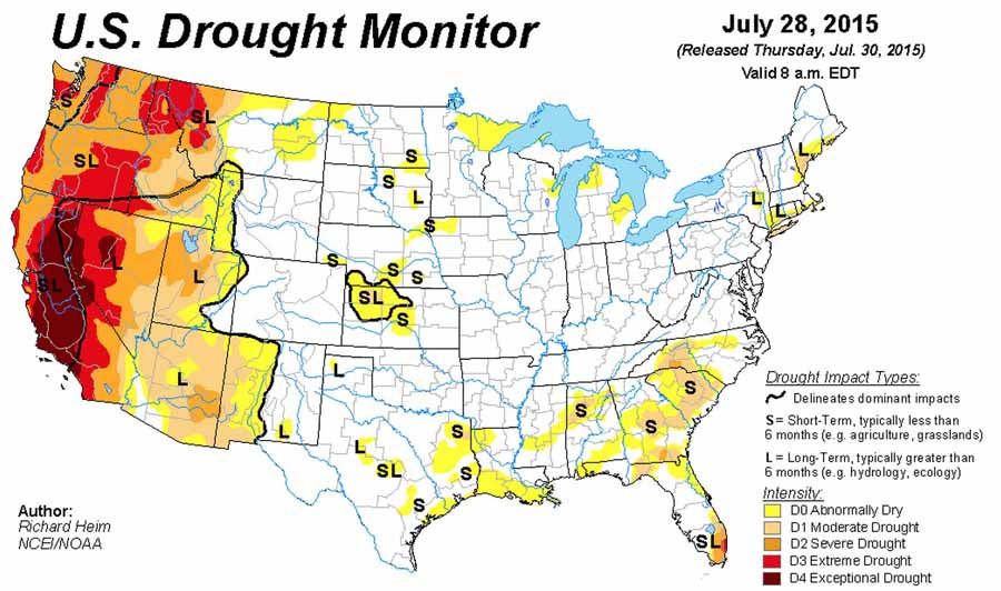
As a bonus, here is the Drought Monitor from July 28, 2015:

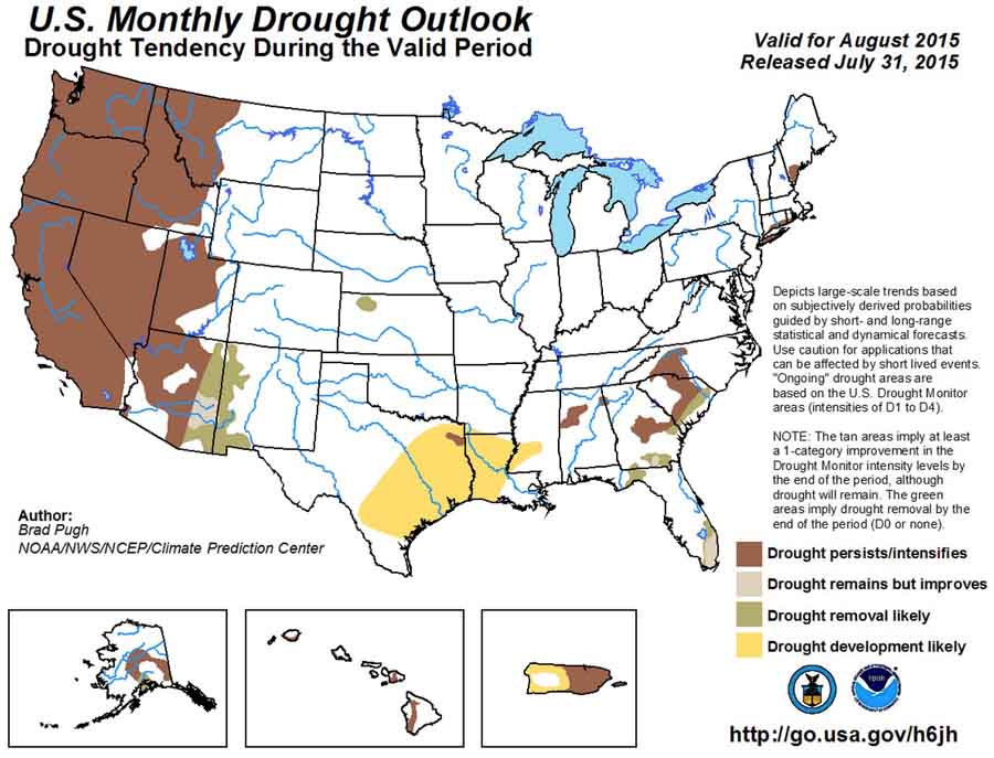
Drought Monitor July 28, 2015And, the U.S. Drought Outlook for August:

US Drought Outlook, August, 2015


Warmest day of the year

Warmest day of the year

From NOAA’s National Centers for Environmental Information:

****

“During the summer months, many areas in the United States approach their highest temperatures for the year. To give you a better idea of the warmest time of year for your area, NCEI has created these “Warmest Day of the Year” maps for thecontiguous United States, Alaska, Hawaii, and Puerto Rico. The maps are derived from the 1981–2010 U.S. Climate Normals, NCEI’s 30-year averages of climatological variables including the average high temperature for every day. From these values scientists can identify which day of the year, on average, has the highest maximum temperature, referred to here as the “warmest day.”

Although the amount of solar radiation reaching Earth peaks at the summer solstice on June 21 in the Northern Hemisphere, temperatures for most of the United States tend to keep increasing into July. The temperature increase after the solstice occurs because the rate of heat input from the sun during the day continues to be greater than the cooling at night for several weeks, until temperatures start to descend in late July and early August.

But, this isn’t the case everywhere! The “Warmest Day of the Year” maps show just how variable the climate of the United States can be. For instance, the June values in New Mexico and Arizona reflect the North American Monsoon, a period of increased rainfall affecting the U.S. Southwest. Because these areas tend to be cloudier and wetter from July through September, the temperature is highest on average in June. Similarly, the persistence of the marine layer along the Pacific Coast leads to cool temperatures in early summer with the warmest days on average later in the season.”

Vane mount for Kestrel weather meter

Kestrel vane mount
Kestrel Portable Vane Mount. Kestrel photo.

Many wildland fire crews carry some sort of pocketable weather monitoring device, ranging from a sling psychrometer to an electronic weather meter which can cost up to many hundreds of dollars.

After seeing a Tweet by Southeast England Wildfire Group about a wind direction vane mount for a Kestrel weather meter, we checked it out and it’s a real thing. It is designed to be tripod-mountable and can hold any Kestrel weather meter. The idea is that the mount will rotate so that the back of the meter always faces into the wind, enabling accurate wind speed readings. This could be useful if you’re going to be in the same place for a long time, your meter can log the data which you intend to upload onto a computer, or if your meter has Bluetooth capability.

It has received mixed reviews on Amazon, and is priced at $41.18 to $63.06 from various sellers, some without Prime free 2-day shipping. At one point it came with a small tripod (which was criticized by reviewers), but appears now to come without it.