Fire weather outlook, August 5-10

Today we are beginning what could be a recurring feature on Wildfire Today. Chip Redmond, a qualified Incident Meteorologist, has written a fire weather outlook for August 5 through 10. Tomorrow we will have his description of what is considered typical fire weather in the month of August, along with a general outlook for the rest of this month.

Here is a short bio for Chris, and below that is his forecast.

Chip Redmond has studied meteorology extensively, obtaining both a Bachelors and Masters degree in Atmospheric Science. His knowledge of weather was then combined with wildland fire in 2012 through a wildfire meteorology course, where he obtained a passion for the specialized niche. Since then, he has served as an IMET with the state of South Dakota, working on the fire line and with an incident management team. From these experiences, he believes that nothing is more beneficial than making a forecast, and subsequently watching your forecast either verify or completely blow while working on the fire line. Current endeavors have taken him to Kansas, where he works with the state climate office and state-wide weather station network. During this phase in his career, he remains thoroughly embedded in fire weather forecasting and hopes to combine these experiences in the future.

****

August 5 – 10 Fire Weather Discussion

Extreme fire weather conditions have been somewhat hampered due to abundant moisture streaming northward across much of the western US. This has helped relieve some large fires that have developed, especially across CA/OR. Improving conditions are linked to the lack of dry thunderstorm activity, and increased moisture across the region. The large upper level ridge that has dominated the weather for the western US lately has been modified due to an impinging upper level low centered over California/Great Basin. This upper level low will slowly transition southward through the end of the week. Chances of wet thunderstorms will exit eastward across the Rockies and into the central Plains, with some lingering across northern CA into south ID into the weekend. With no upper level forcing, chances of thunderstorms will be restricted to terrain flows near high peaks, and no widespread lightning episodes expected.

Winds will be generally light across the western US with no significant events expected the next 4-5 days. However, some areas of localized influences on the western slopes of the Cascades in OR/WA may see combinations of westerly winds 15-20mph and RHs below 15%-borderline Red Flag conditions. A shortwave will push southeast into the Pacific Northwest over the weekend increasing thunderstorm chances possibly both dry and wet. Despite these chances, drought conditions expected to persist with below normal rainfall and above normal temperatures the next 7 days. Heat and dry conditions are expected to re-amplify early next week as the persistent pattern attempts to build back into the region.

Weather highlights for Wednesday through Sunday:

CA: Persistent higher elevation showers/thunderstorms across north and east CA through Saturday. Drying out south with heat returning.

OR/WA: Persistent breezy westerly winds and dry conditions Wed, Thurs, & Fri will create near Red Flag conditions across western slopes of Cascades and central OR/WA. Dry through the week with scattered wet/dry thunderstorms Saturday.

ID/WY/MT: Periods of wet thunderstorms especially across east ID, south MT, and WY.

Chip

Wildfire potential, August through November

The Predictive Services section at the National Interagency Fire Center has issued their Wildland Fire Potential Outlook for August through November, 2014.

The data represents the cumulative forecasts of the eleven Geographic Area Predictive Services Units and the National Predictive Services Unit. If their predictions are accurate, firefighters could be busy in Washington, Oregon, and California.

August

Wildfire potential for August, 2014

  • Above normal fire potential will continue across much of the West Coast states. Southwestern Puerto Rico has been unusually dry this summer and has above normal fire potential.
  • Fire potential will return to normal across portions of the Northern Rockies and Rocky Mountain Areas.
  • Below normal fire potential is expected for western Oklahoma, western Texas, southeastern New Mexico and much of the coastal Southeast.

September

Wildfire potential for September, 2014

  • Above normal fire potential will persist across the western states through September with fire potential returning to normal over eastern portions of Northern California and Northwest by late September.
  • Below normal fire potential will continue over the southern Plains, the mid-Mississippi Valley and part of the Southeast. Hawaii will remain below normal potent.

October and November

Wildfire potential for October-November, 2014

  • Above normal fire potential will remain over southern California through the fall while Northern California, Oregon and Washington return to normal, essentially ending their significant fire season.
  • Below normal fire potential will continue across the southern U.S. and the mid-Mississippi and Tennessee Valleys. Hawaii will also remain below normal.

High temperatures forecast for the West through August 13

Temperatures higher than normal are in the forecast through August 13 for Alaska, Washington, Oregon, California, and parts of Idaho, Montana, Nevada, and Arizona. If ignitions occur, firefighters could be busy in the far west for the next couple of weeks, while those farther east will see temperatures cooler than normal.

August 1 through 5:

Temperature outlook, Aug 1-5
August 1 through 5.

August 7 through 13:

Temperature outlook, Aug 7-13
August 7 through 13.

Thanks and a hat tip go out to Jim.

Wildfire potential, July through October, 2014

Posted on Categories UncategorizedTags ,

The Predictive Services section at the National Interagency Fire Center has issued their Wildland Fire Potential Outlook for July through October, 2014. The data represents the cumulative forecasts of the eleven Geographic Area Predictive Services Units and the National Predictive Services Unit. If their predictions are correct, the wildfire season will be busier than usual in the states of California, Washington, Oregon, Idaho, Nevada, and Arizona.

July

July wildfire potential

  • Above normal fire potential will persist over much of California, the Northwest and the Great Basin. Southern Arizona and southwestern New Mexico will return to normal in July.
  • Below normal fire potential will continue for much of the south central and southeast U.S. Below normal potential will also become prevalent across portions of the Northern Rockies and Rocky Mountains.

August

August wildfire potential

  • Above normal fire potential will continue over most of California, Nevada, Oregon, Washington and Idaho. Above normal conditions could possibly develop across the New England states and Four Corners area if short-term weather develops that would support fire outbreaks.
  • Below normal fire potential will continue over northern Idaho, Montana and portions of Wyoming, Colorado and South Dakota. Portions of Texas, Oklahoma, Arkansas, Tennessee, Louisiana and Mississippi will also continue to see below normal fire potential.

September through October

September October wildfire potential

  • Above normal fire potential will remain over Southern and Central California. Northern California, Oregon and Washington will return to normal during this period.
  • Below normal fire potential will return across much of the Southeastern U.S. except for gulf coastal areas and most of the Coastal Atlantic states.

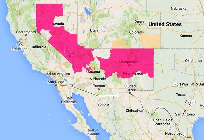
Red Flag Warnings, June 2, 2014 — and, controlling the weather

wildfire Red Flag Warnings - June 2, 2014

Warnings for elevated wildfire danger have been issued by the National Weather Service for areas in Nevada, Utah, Arizona, New Mexico, and Colorado.

We continue to be amazed at how weather and fire danger can respect and adhere to state boundaries. The Joint Fire Science Program should investigate this phenomenon. Maybe additional imaginary lines could be put on maps on an as-needed basis that would control the weather to protect our firefighters, forests, and communities. Could we even reverse droughts and prevent floods?

The Red Flag Warning map was current as of 11:23 a.m. MDT on Monday. Red Flag Warnings can change throughout the day as the National Weather Service offices around the country update and revise their forecasts. For the most current data, visit this NWS site.