Wildfire potential, April through July, 2012

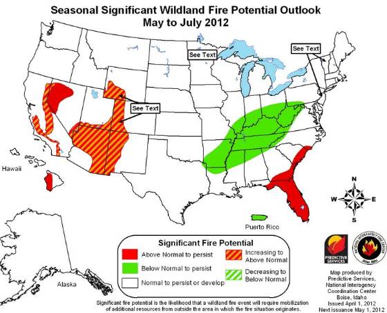
The Predictive Services section at the National Interagency Fire Center has issued their National Wildland Significant Fire Potential Outlook for April through July, 2012. If correct, Arizona, New Mexico, Florida, and portions of California and Nevada will experience above normal wildfire potential for the months May through July.
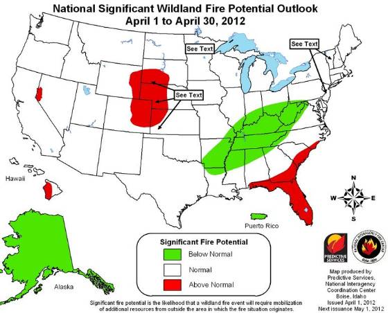
Monthly Wildfire Outlook April 2012
Seasonal Wildfire Outlook May-July 2012

Below is a summary of the wildfire potential:

Significant Fire Potential

  • Above Normal Significant Fire Potential is expected along the east coast from near Wilmington, North Carolina, to near Panama City, Florida, including all of the Florida peninsula; most of northwestern Nevada; foothills and inland valleys of southern California; and the lee side of the Hawai’in Islands.
  • Significant Fire Potential will increase to above normal in the spring across most of Minnesota, northern Wisconsin, the upper peninsula of Michigan and northwestern Iowa; central and western New Mexico, most of Arizona, southern Nevada, far southern Utah and extreme southwestern Colorado.
  • Below Normal Significant Fire Potential is expected for much of the Ohio and Tennessee Valleys, the middle and lower Mississippi Valley, and Puerto Rico. The rest of the country will have normal significant fire potential.

Climate and Drought Conditions

  • La Niña will continue to weaken as oceanic trends point to warming of the equatorial Pacific through spring, favoring a neutral or weak El Niño cycle by early summer.
  • Warmer than normal temperatures are expected across much of eastern two-thirds of the U.S.in March and transitioning to above normal across just the southern half of the country. Below normal temperatures are expected for the West coast and much of Alaska.
  • Precipitation is expected to be below median for most of the southwest, central and southern Plains, and the Gulf coastal region including all of Florida, and southern Alaska. Above median precipitation is expected for the Northwest and northern Rockies, the Upper Midwest, theGreat Lakes region, and the Ohio and mid-Mississippi valleys.
  • Drought will persist through much of the lower Atlantic and Gulf coasts, most of the southwestern and south central U.S., most of central and northern California, the western Great Basin, and the upper Mississippi valley. Drought will likely develop across the northern Plains, the eastern Great Basin and central Rockies, and southern California. There will be some improvement in the Northwest, parts of northern California, east Texas, and on the lee sides of the Hawai’in Islands.

Monday wildfire one-liners, March 26, 2012

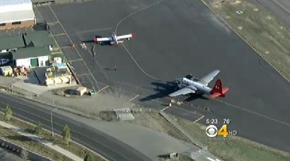
Screen grab from report about Colorado wildfire conditions
Screen grab from CBS Denver report about Colorado wildfire conditions

Excellent photos of a P2V and an Air Tractor 802A at Jeffco Air Tanker Base in Colorado.

Annual wildfire refresher available, online and by DVD. Warning: a lame, pointless video with audio will automatically play for about 15 seconds when you visit the NIFC web site.

Video report about wildfire conditions in Colorado.

U.S. Forest Service starts women’s firefighting boot camp.

Two boys ordered to pay $10,000 each for starting fire near Gardnerville, NV.

New Hampshire man uses gasoline to ignite brush pile, is treated at hospital for burns on hands and face.

Two Single Engine Air Tankers begin their 7-day journey from Australia to the United States.

Meteorologist gives early prediction of a normal fire season for the northern Rockies.

One home and two outbuildings burn in three-acre wildfire in Chimayo, NM.

During the past 10 years, the Alabama Forestry Commission’s staff has been reduced by more than 300 employees.

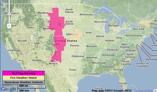
More red flag warnings, March 26

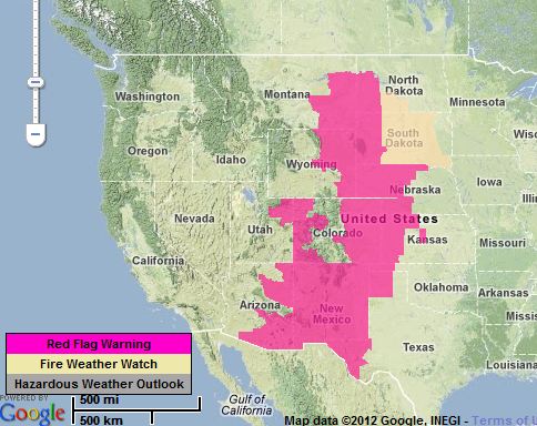
Red flag warnings 3-26-2012
Red flag warnings for March 26, 2012

More information about the red flag warnings.

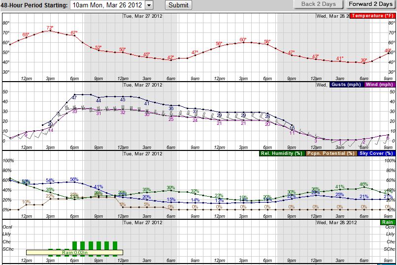
The weather in western South Dakota is going to be interesting for the next day or two as you can see in the hourly graph below. The relative humidity will be above 50% until noon, when it drops into the low 20s. The wind will increase during the afternoon as a front comes through; 30+ mph with gusts in the mid-40s. And on Tuesday we’ll again see strong winds, 20+ with gusts around 30, with the RH about 20%.

South Dakota graphical weather forecast March 26, 2012

x

Record-setting high temperatures in March

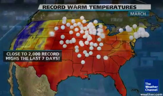
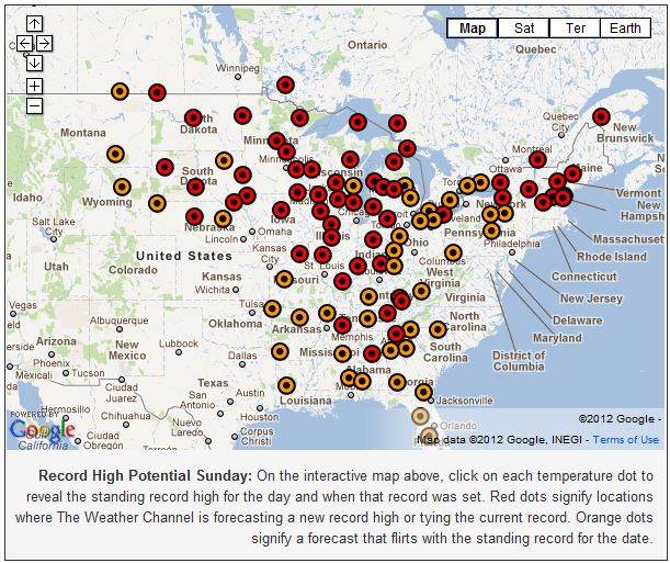
USA map record high temperatures
Map: Weather Channel

I continue to be amazed at the extraordinary, record-setting high temperatures across much of the United States. According to The Weather Channel, approximately 2,000 record highs have been recorded in the last seven days. One of the effects of this we are seeing is the wildfire occurrence occurring a couple of months earlier than normal in the Northern Rockies and Great Plains areas.

The map below is a screen grab of an interactive map at the The Weather Channel web site, at which you can click on a dot to see the high temperature predicted for today, March 18, and how much it will exceed the record high for this date.

Record high temperatures forecast 3-18-2012
Credit: Weather Channel

Some of the more notable high temperature records that are predicted for today include:

  • Bismarck, ND  +10
  • Williston Sloulin AP, ND  +12
  • Rochester, MN  +17
  • Houghton Lake, MI  +12
  • Burlington, VT  +13

On Wednesday the temperature in Traverse City, Michigan was 81, which was 42 degrees above the average for that date, and 4 degrees above the previous high, according to records that go back to 1897.

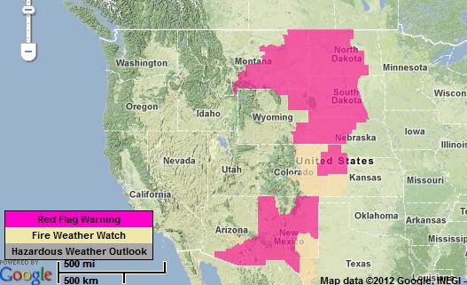
Red Flag Warnings, March 16

Map red flag warning 3-16-2012

Again, much of the United States is under a Red Flag warning today, and in some areas the high fire danger will last through the weekend. Fire danger like this is unusual for the Great Plains and Northern Rockies this time of the year. Like Havre (Montana) Fire Department Chief Dave Sheppard said earlier this week about the 12,000-acre fire they had on Tuesday:

We typically don’t see these types of fires until May or June. It’s tinder dry out there. It’s like August fuels right now. If we don’t get some moisture, it’s going to be a long summer.

Most of the Red Flagged areas are expected to have low humidities with gusty winds, and some will have near record high temperatures.

Oh, and in case you are planning to travel to Guam they also have a Red Flag warning “for the explosive spread of wildfire”.