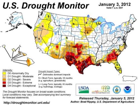
As you can see from the snowpack and drought maps, much of the west and south are very dry. If these conditions linger throughout the winter, it could be an interesting fire season in many areas. The snowpack map helps explain the two recent large fires in northwest Montana 30 miles south of the Canadian border (map).
Along with news of the 45,000 to 55,000 acres that have burned near Browning, Montana over the last 18 hours, comes more news that several cities in the United States are setting records today for high temperatures for the date. Below are the highest recorded so far today, which are already new records, with a few more hours of heating left:
Fargo, ND 44
Grand Forks, ND 43
Mitchell, SD 52
Kalispell, MT 52
Record high temperatures can mean more wildfires and more opportunities for prescribed fires. Steve Ispwitch, the Fire Management Officer of the Standing Rock Agency in South Dakota and North Dakota, wrote to us today:
I have submitted my third severity request so far in fiscal year 2012 for Standing Rock Agency, all of which have been approved. It has been unusually warm and dry since October, and we have had a couple of 170 acre fires in October and November that we caught with our engines and a SEAT. We have also been taking advantage of the ability to conduct prescribed burning when possible. We burned on December 28 and January 4, the latest and earliest perscribed fires (respectively) in any given year so far. Stay safe…
Right now, at 12:03 p.m MT, it is 61 here in southwest SD. I don’t know if that’s a record, but it has led to my decision to go hop on the motorcycle and take advantage of this great January weather. See ya!
The Predictive Services section at the National Interagency Fire Center has issued their National Wildland Significant Fire Potential Outlook for January through April, 2012. According to their prediction, most of the United States is in for a quiet first part of the year with the exception of parts of Minnesota, New Mexico, Texas (as usual), Georgia, South Carolina, and Florida.
According to NIFC, the primary factors influencing these outlooks are:
La Niña: La Niña conditions will continue over the tropical Pacific and typical weather patterns will return to the US after intraseasonal circulations disrupted the classic La Niña patterns over North America in December.
Drought: Significantly above normal precipitation fell in December over parts of the front range of the southern Rockies, the central Plains and the Ohio Valley. Parts of central and west Texas, southwest New Mexico and southern Arizona also received above normal precipitation. Much of the West, the central and southern Rockies, the northern Plains and Florida received less than 50 percent of normal precipitation for the month.
Fuel Dryness: Fuel conditions continue to improve across most of the U.S. As winter progresses and La Niña returns the northern tier of the country will see fuel conditions that are not conducive to significant fires. The far southern portions of the country, however, will begin to experience drier and warmer periods as La Niña sets in. Even though these will not be as strong as last year, expect fuels conditions to dry significantly and support significant fires across the Southwest and the far Southeast.
The predicted strong winds have hit much of southern California, at least in the far north and the Los Angeles areas. The city of Pasadena declared a local state of emergency because of downed power lines and the streets being littered with tree limbs. The mayor asked for help from Los Angeles County Public Works to help clear the streets. The city schools and libraries are closed today.
Wind gust speeds in the Los Angeles area, 9:43 a.m. PT 12-1-2011
As of 7 a.m. local time about 300,000 utility customers across Southern California were hit with power outages as the Santa Ana winds caused damage throughout the region. But the winds in San Diego County, where San Diego Gas and Electric turns off the power during periods of extreme winds, they are comparatively mild and the gusts have not yet met the the threshold for flipping the switch, according to the SDG&E site.
Red Flag Warning map 12-1-2011
Here are some of the strongest wind gusts we were able to find in California:
94 mph, Mt. Elizabeth near Sonora
106 mph, Grey Butte, near Mt. Shasta
97 mph, Whitaker Peak, near Castaic Lake
72 mph, San Rafael Hills, near Glendale
83 mph, Acton
We are not aware of any fires larger than 100 acres burning in the area – yet.
The prediction is for the strong winds to continue through Friday afternoon. Below is the latest red flag warning from the National Weather Service for the Los Angeles area. (Maybe one day the NWS will fix that damned CAPS LOCK key):
…RED FLAG WARNING IN EFFECT THROUGH LATE FRIDAY AFTERNOON OVER LOS ANGELES AND VENTURA COUNTIES FOR STRONG OFFSHORE WINDS AND MODERATELY LOW RELATIVE HUMIDITY…
A COLD LOW PRESSURE SYSTEM OVER ARIZONA WILL CONTINUE TO GENERATE STRONG NORTH TO NORTHEAST OFFSHORE WINDS OVER MOST OF LOS ANGELES AND VENTURA COUNTIES THROUGH MOST OF FRIDAY. PEAK SUSTAINED WINDS ARE EXPECTED TO EXCEED 40 MPH…ESPECIALLY ACROSS PORTIONS OF THE VALLEYS AND MOUNTAINS…WITH PEAK WIND GUSTS LIKELY EXCEEDING 60 MPH. THESE WINDS WILL ALSO HELP TO MAINTAIN LOW HUMIDITY READINGS…ESPECIALLY OVER THE COASTS AND VALLEYS. ALTHOUGH THESE WINDS SHOULD WEAKEN BY FRIDAY EVENING…THE POTENTIAL EXISTS FOR ANOTHER ROUND OF GUSTY NORTHEAST WINDS LATE SATURDAY INTO SUNDAY.
During a red flag warning last week for predicted strong winds in southern California, San Diego Gas and Electric staged contract wildland firefighters in remote areas of San Diego County to be able to respond quickly if a power line failure caused a fire. Using an automatic system, SDG&E called 11,500 residents in the eastern parts of the county to warn them that the utility could turn off their power if they determined that the fire danger reached a predetermined threshold. The utility has recently installed 130 weather stations in their service area that transmit data via a cell phone network to their headquarters.
…“We used to have only one weather station per circuit, and now some circuits have as many as five, so we can try to pinpoint the potential impact of weather on our system,” [SDG&E spokesman Stephanie] Donovan said. “We also began staging crews in wind-prone areas to hasten response time.”
A typical crew is four SDG&E troubleshooters and two or three firefighters, who are part of a contract wildfire strike team hired by the utility.
“SDG&E had about 90 people staged in the areas where the highest winds were forecast,” Donovan said. “This included our distribution crews, contract firefighters, transmission construction and maintenance crews, and even Telecomm personnel.”
The staging of observers turned out to be “invaluable,” she said.
“Specifically, an electric troubleshooter out of SDG&E’s construction and operations center in Escondido followed fire trucks onto Tribal Road within the Rincon Reservation to find poles and wire down with a half-acre fire. It was determined the line was a 2.4 kilovolt customer-owned equipment,” Donovan said.
“Another troubleshooter patrolling a line came across a leaning pole with secondary wire in the Rincon area, and was able to call it in and get it fixed. Finally, one of SDG&E’s weather stations in the Santa Ysabel area stopped updating in the middle of the event, so one of the stand-by crews was sent to troubleshoot the issue and soon had the weather station back on line communicating via cellular modem.”
The Predictive Services section at the National Interagency Fire Center has issued their National Wildland Significant Fire Potential Outlook for November, 2011 through February, 2012. According to their prediction, Texas will continue to experience “extreme to exceptional drought conditions”.