Flying through a pyrocumulonimbus cloud

NASA Earth Observatory image Williams Flats Fire
NASA Earth Observatory image of the Williams Flats Fire by Joshua Stevens, using Landsat data from the U.S. Geological Survey.

(This article first appeared at earthobservatory.nasa.gov)

Atmospheric scientists regularly take note when satellites detect thunderheads rising above columns of wildfire smoke. These “fire clouds”—experts call them pyrocumulonimbus (pyroCb) or cumulonimbus flammagenitus—are caused when fires loft enough heat and moisture into the atmosphere to produce thunderstorms.

On August 8, 2019, a team of atmospheric scientists got an exceedingly rare look at these clouds as they were forming. NASA’s DC-8 flying laboratory passed directly through a large pyrocumulonimbus that day as it was rising from a fire in eastern Washington. The flight was part of a joint NOAA and NASA field campaign called FIREX-AQ. Scientists are studying the composition and chemistry of smoke to better understand its impact on air quality and climate.
Williams Flats Fire
August 8 photo by David Peterson (U.S. Naval Research Laboratory).

David Peterson, lead forecaster for FIREX-AQ, was in the cockpit of NASA’s DC-8. “The views were absolutely stunning,” said Peterson. “Very few photographs of large pyroCbs are available, especially from the air.”

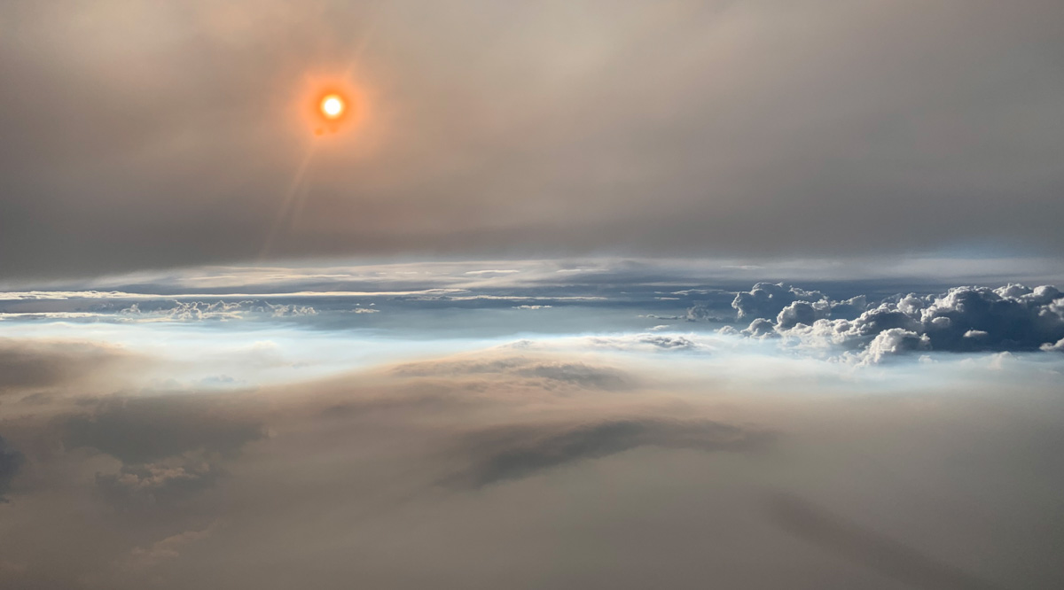
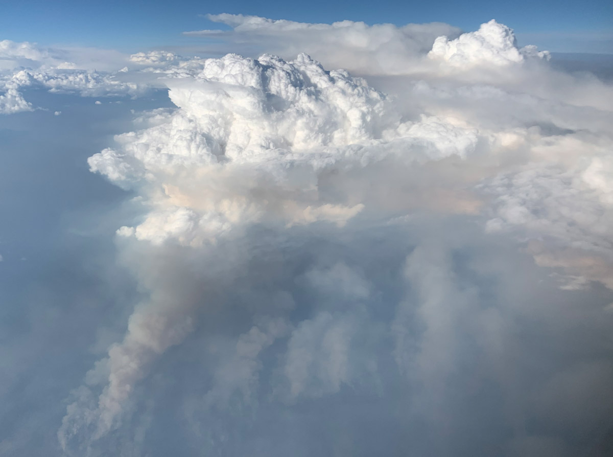
The photograph above, shot from roughly 30,000 feet (9 kilometers), shows the setting Sun shining through thick smoke at 8 p.m. Mountain Time. Particles in the smoke reflect light in ways that make the Sun appear orange. The photograph below shows the smoke plume (gray) that fed the pyrocumulonimbus cloud (white).

The flight was the most detailed sampling of a pyrocumulonimbus in history, explained Peterson. A second research aircraft flew over the plume a few hours earlier in the day, and mobile labs on the ground also made detailed measurements.
Williams Flats Fire
August 8 photo by David Peterson (U.S. Naval Research Laboratory).

“PyroCb are like large chimneys, transporting a large quantity of smoke into the lower stratosphere,” explained Peterson.

When smoke does reach the stratosphere, it tends to spread globally and remain high in the atmosphere for longer periods—months or even years—than smoke that stays in the lower troposphere. One recent study concluded that the largest fire clouds can even lift quantities of smoke aerosols into the lower stratosphere that are comparable to a moderate-sized volcanic eruption.

An early morning thunderstorm ignited the Williams Flats Fire on August 2, 2019. The Operational Land Imager (OLI) on Landsat 8 acquired a natural-color image of the blaze (at the top of the page) as it approached the north bank of the Columbia River on August 7, 2019. The image is natural color (OLI bands 4-3-2), overlaid with the infrared and shortwave infrared signature of actively burning fires.

Story by Adam Voiland of NASA Earth Observatory.

Williams Flats Fire grows to over 34,000 acres in Northeast Washington

map Williams Flats Fire
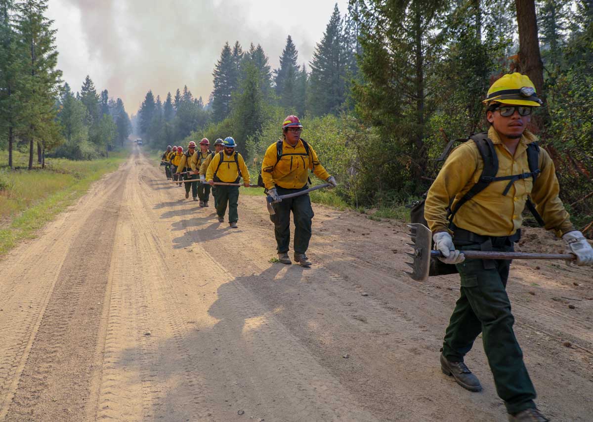
A crew on the Williams Flats Fire, August 6, 2019. InciWeb.

The Williams Flats fire in northeast Washington was very active Wednesday and Wednesday night, spreading to the east an additional one to two miles and reaching BIA Road 11 less than half a mile from the Columbia river on the east side of the fire

The Incident Management Team released information about a new evacuation order at about 7 p.m. Wednesday, but unfortunately no map was provided:

The Level 1 Evacuation has now been elevated to a Level 3 Evacuation Notification – “Leave Now” by the Colville Tribes Emergency Services and the Ferry County Sheriff’s Office.

While homes are not immediately in danger, the only road out may be cut off by fire. Now is the time to evacuate. Anyone who remains in the area may not be able to leave once the fire reaches the Nine Mile-Hellgate Road.

The evacuation zone is as follows: From the intersection of Little Nine Mile Creek with the Nine Mile-Hellgate Road, draw a straight line west to the Whitestone Lookout. All areas south of that line are now at a Level 3 Evacuation —-”Leave Now”. All residents of the area are advised that for their own safety, they need to leave now.

Official and more current information is at the Ferry County Sheriff’s Office Facebook page.

The area is under a Red Flag Warning on Thursday.

Williams Flats Fire crew
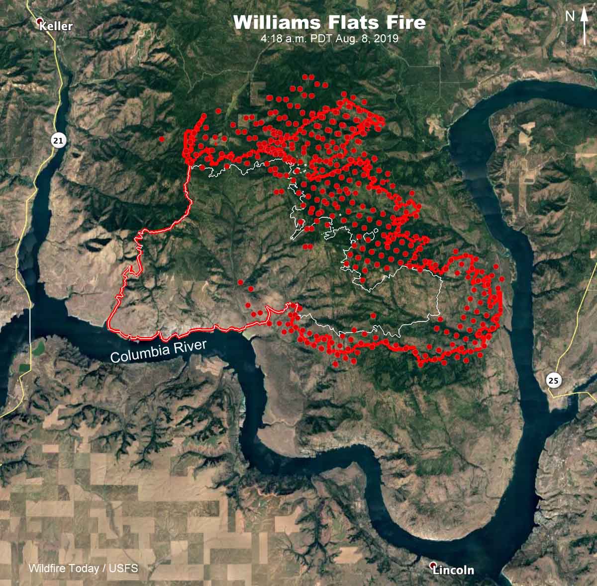
Map showing the location of the Williams Flats fire in northeast Washington. The red line was the perimeter determined by a fixed wing mapping flight at 11:53 p.m. PDT August 7, 2019. The white line was the perimeter 26 hours before. The red dots represent heat detected by a satellite at 4:18 a.m. PDT August 8, 2019.

Williams Flats Fire spreads to the east and north

The fire is 15 miles east of Coulee Dam, Washington

3-d map Williams Flats Fire Washington
3-D map showing the location of the Williams Flats fire in northeast Washington, looking east. The red line was the perimeter determined by a fixed wing mapping flight at 11:08 p.m. PDT August 5, 2019. The red shaded areas represent intense heat. The white line was the perimeter 26 hours before.

(UPDATED at 8:17 a.m. PDT August 6, 2019)

On Monday the Williams Flats Fire in Northeast Washington spread for another half mile to a mile toward the north and east, to bring the total burned area up to 16,781 acres according to data from an overnight fixed wing mapping flight. (see map above)

The fire spread across Whitestone Ridge on the southeast flank.  Dozers are constructing direct fireline and crews are burning out fuels as construction progresses toward the fire’s northeast corner. Helicopters were able to drop water as needed Monday to reduce the risks of loss to timber, Hellgate Game Reserve, and archeological sites, but water-scooping planes and large air tankers were unable to fly due to heavy smoke which compromised visibility.

Challenges firefighters are facing on this include high temperatures, reduced visibility, steep rocky terrain, and wildlife dangers such as snakes and bears.

Firefighting resources assigned to the Williams Flats Fire:

  • 22 hand crews
  • 8 helicopters
  • 18 fire engines
  • 9 dozers
  • 22 water tenders
  • 764 total personnel

(Originally published at 1 p.m. PDT August 5, 2019)

Williams Flats Fire Washington
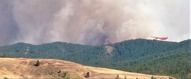
Retardant can be seen in the distance being dropped on a ridge on the Williams Flats Fire. The photo was uploaded to InciWeb August 4, 2019.

The Williams Flats Fire along the Columbia River 15 miles east of Coulee Dam, Washington spread half a mile to one mile on the north and east sides on Saturday and Sunday to bring the size up to 13,497 acres.  (see map below)

The fire is burning on Confederated Tribes of the Colville Reservation and Washington Department of Natural Resources protected lands. On Monday firefighters will strengthen existing containment lines and begin mop-up of hot spots on the west flank. Line construction is on-going on the southeast flank toward Whitestone Ridge. Dozers are constructing direct fireline and crews are burning out fuels as construction progresses toward the fire’s northeast corner.

Williams Flats Fire Washington
The Incident Management Team titled this photo, “Success at the goat ranch”. It was uploaded to InciWeb August 4, 2019. A single-engine air tanker can be seen scooping water from the Columbia River.

Firefighting resources assigned to the Williams Flats Fire include 14 hand crews, 18 fire engines, 8 dozers, 19 water tenders, and 7 helicopters for a total of 542 personnel.

Helicopters are dipping and air tankers are scooping water (see above) from nearby Lake Roosevelt to aid on-the-ground firefighters in suppression efforts and the aircraft need space to work. The public is asked to avoid these activities on the water. The area is being patrolled by the the Confederated Tribes of the Colville Reservation Law Enforcement.

Weather

The forecast for Monday calls for 91 degrees, 15 percent relative humidity, and winds out of the southwest and west at 6 mph, with limited humidity recovery Monday night. Tuesday should be the hottest day of the week, with 94 degrees, 14 percent RH, and variable winds at 2 to 7 mph.

map Williams Flats Fire Washington
Map showing the location of the Williams Flats fire in northeast Washington. The red line was the perimeter determined by a fixed wing mapping flight at 9:41 p.m. PDT August 4, 2019. The white line was the perimeter 47 hours before. The red dots represent heat detected by a satellite at 3:35 a.m. PDT August 5, 2019.
3-d map Williams Flats Fire Washington
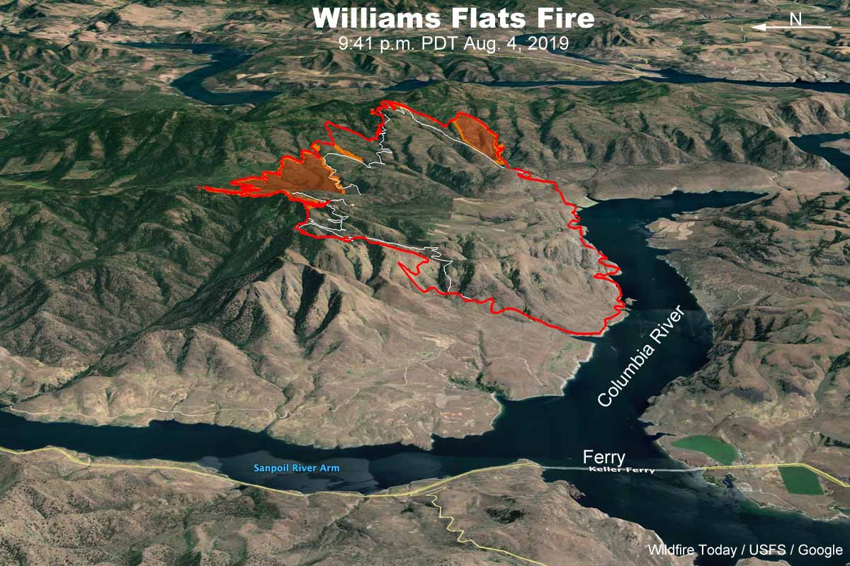
3-D map showing the location of the Williams Flats fire in northeast Washington, looking east. The red line was the perimeter determined by a fixed wing mapping flight at 9:41 p.m. PDT August 4, 2019. The white line was the perimeter 47 hours before.


Williams Flats Fire burns thousands of acres along Columbia River

The fire is 15 miles east of Coulee Dam, Washington

3-d map Williams Flats Fire Washington
3-D map showing the APPROXIMATE perimeter of the Williams Flats Fire looking east, based on heat detected by a satellite at 2:56 p.m. PDT August 3, 2019. The map should not be used for planning or evacuation decisions.

(UPDATED at 5:50 p.m. PDT August 3, 2019)

In an update at 2 p.m. Saturday fire officials reported that the Williams Flats Fire 15 miles east of Grand Coulee, Washington had grown to 8,200 acres. (see map above)

On Saturday firefighters constructed containment lines to protect the valley floor and worked on anchoring the southern perimeter of the fire, which is spreading east toward Redford Canyon. That area was logged five years ago leaving behind slash fueling the fire. Steep slopes, limited roads, and primitive road conditions are hampering control efforts.

Tribal Natural Resources Officers are patrolling Lake Roosevelt Recreation Area to keep boaters safe as three Fire Boss water-scooping single engine air tankers obtained water from the Columbia River.

Other resources on the fire include:

  • 3, large air tankers
  • 1,Type 1 helicopter
  • 4, 20-person hand crews
  • 2, 12-person hand crews
  • 3, dozers
  • 12, Type 6 fire engines, and
  • 5, water tenders
  • For a total of 132 personnel

(Originally published at 10:02 a.m. PDT August 3, 2019)


The Williams Flats Fire in Northeast Washington burned well over 5,000 acres during the first 25 hours after being reported at 3:23 a.m. Friday August 2, 2019.

Saturday morning fire officials said it was 5,640 acres, but satellite data from 4:18 a.m. PDT on Saturday indicates it may have burned an additional 1,000 acres. (see map above below)

Map Williams Flats Fire
Map of the Williams Flats Fire showing heat detected by a satellite as late as 4:18 a.m. PDT August 3, 2019.

Exhibiting extreme fire behavior during Red Flag Warning Conditions, the blaze spread east along the Columbia River 8 miles southeast of Keller and 15 miles east of Grand Coulee, threatening structures. Evacuations are occurring, according to the Northwest Area Coordination Center.

At 6 p.m. Saturday a Type 2 Incident Management Team led by Incident Commander D. Johnson will assume command.

The fire is within the Hellgate Game Preserve on the Colville Indian Reservation.

The fire initially consumed primarily grass, but moved into heavier vegetation. It is fueled by fallen dead trees, grass, sage, and bitter brush, exacerbated by limited access along the Columbia River. Initial suppression efforts included building hand lines, dozer lines, and working from existing roads. Helicopters and fixed winged aircraft cooled hotspots on Friday to allow ground forces time to engage. On-the-ground firefighters are dealing with extremely steep rocky slopes and rattlesnakes.

Weather

On Friday the fire was pushed by 5 to 12 mph winds out of the southwest and west gusting at 15 to 25 mph, but after midnight the direction reversed to come out of the east, according to the Wellpinit weather station south of the fire. Friday’s temperature reached 90 degrees with a relative humidity of 21 percent.

The forecast for Saturday calls for 84 degrees, RH of 14 percent, with 2 to 5 mph winds out of the north shifting to the east in the afternoon. These conditions should reduce the resistance to control of the fire, compared to what firefighters were faced with on Friday.