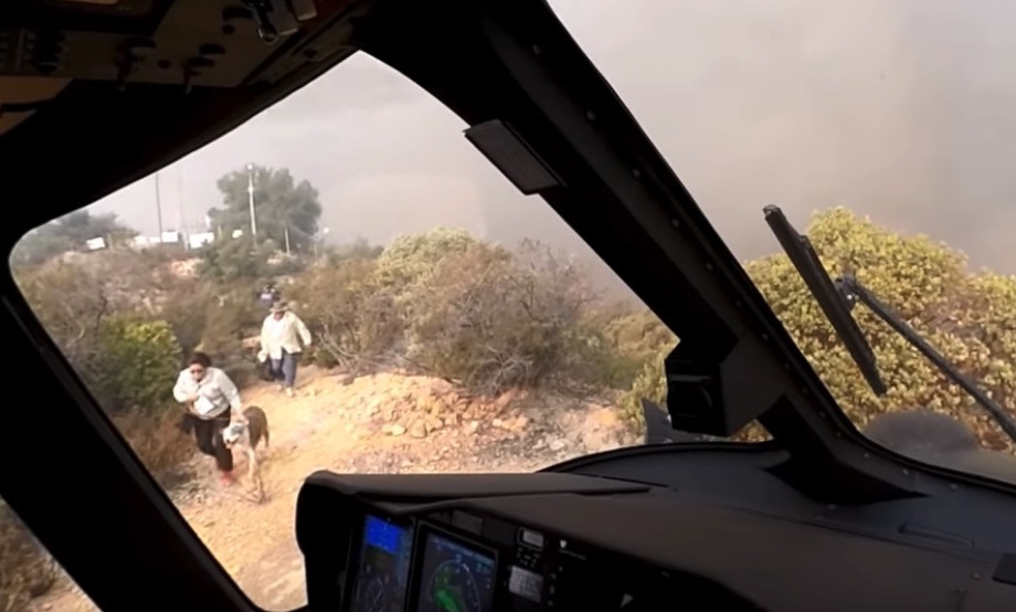
Three people and two dogs were were evacuated as the fire approached
Screenshot from the LA Fire Department video below. Three people and two dogs were rescued as the Woolsey Fire approached.
(Originally published at Fire Aviation)
While on a water dropping mission on November 9, the second day of the Woolsey Fire in Southern California, a Los Angeles Fire Department helicopter received a new assignment. Civilians were trapped on a mountain top as the fire approached. Even as they were running critically low on fuel the pilots found a way to land on a ridge top that was littered with communication towers and vehicles.
The video below was shot from a pilot’s helmet camera.
It was great work, team work, by the pilots to successfully pull this off. We appreciate that he filmed what they were doing, and that their department approved and helped to publicize the fact that the recording exists. Some public agencies have draconian rules about their employees or the public taking photos or recording video of their activities. Videos like this can help citizens understand what fire departments do and how they are carrying out their missions even as politicians may lob uninformed verbal assaults their way.
CAL FIRE says the Woolsey Fire has burned 96,949 acres and 1,500 structures, with no breakdown of residences vs. outbuildings. The number of civilian fatalities has remained at three for several days.
Mr. Trump toured the fire site after seeing the Camp Fire in Northern California
President Trump visits the Woolsey Fire, November 17, 2018. Screen shot from the ABC7 video below.
(Originally published at 3:07 p.m. PST November 18, 2018)
After President Trump visited the site of the Camp Fire at Paradise, California Saturday, he flew on Air Force One from Beale Air Force Base 360 miles south to NAS Point Mugu about 8 miles west of the western edge of the Woolsey Fire. From there a motorcade took the entourage to where the blaze stopped at the Pacific ocean on November 9 as it was being driven by strong Santa Ana winds out of the northeast. At Malibu the President toured the sites of burned houses on Point Dume with Governor Jerry Brown and Governor-elect Gavin Newsom.
Progression map of the Woolsey Fire, November 17, 2018. Produced by the Incident Management Team. To see a full size version, click HERE (very large 9 MB file).
Firefighting resources are beginning to be released from the Woolsey Fire, and Sunday is the last day that the helibase will be in operation.
CAL FIRE says the fire has burned 96,949 acres and 1,130 structures, with no breakdown of residences vs. outbuildings. The number of civilian fatalities has remained at three for several days.
Officials have lifted evacuation orders for all locations in Ventura County, but remain in effect for some areas in Los Angeles County. Here is a link to official current information about evacuations.
Rain is in the forecast for the fire area on Wednesday with the potential for about 0.7″ in the Thousand Oaks area. There is a 20 percent chance of debris flows below the burn areas, with a possible effect on properties and roadways.
Now that the fire activity has decreased scientists are moving in to begin an assessment of the changes. For example, they have already determined according to the LA Times, that “of 13 mountain lions with radio collars they had been tracking before the Woolsey fire broke out, scientists confirmed that 12 were alive and moving outside of the burned areas.”
The red line on the map of the Woolsey Fire was the perimeter at 7 p.m. PST November 16, 2018. The white line was the perimeter on November 12.
Most of the land within the Santa Monica Mountains National Recreation Area burned, destroying at least 616 structures including the Paramount Ranch where many western-themed shows were filmed. The National Park Service hopes to rebuild the western town within two years with the help of a fundraising campaign in Hollywood.
The death toll increased Thursday evening to a total of 66 for the two fires in California.
Red icons represent structures that are more than 50 percent burned in the Paradise and Magalia areas of the Camp Fire. The full zoomable map is HERE, where a person can search for individual addresses.
(UPDATED at 8:07 p.m. PST November 15, 2018)
Thursday evening fire authorities updated some of the information about the Camp Fire which has devastated areas around the town of Paradise, California. According to the Butte County Sheriff’s Office the number of fatalities has risen to 63, an increase of 7 over the last 24 hours. And surprisingly, the number that are unaccounted for changed from 130 to 631. Some of those could be in shelters, relocated to another part of the state, or without means of communication.
As of Thursday evening the fire has destroyed 9,700 single residences, 118 multi-residences, and 290 commercial structures, for a total of 10,108 buildings.
According to CAL FIRE, the Camp fire has burned 141,000 acres, an increase of exactly 1,000 acres in 24 hours.
(Originally published at 8:25 a.m. PST November 15, 2018)
A total of more than a quarter of a million acres have burned in the Woolsey and Camp Fires in California.
About 460 workers and 22 cadaver dogs are assessing the path that the Camp Fire took as it devastated the town of Paradise in Northern California on November 8. The estimated number of homes destroyed in the blaze is fluid and keeps rising, reaching 8,756 Thursday morning with another 260 commercial structures destroyed. The fatalities the crews have discovered has risen to 56, with 130 people still unaccounted for.
To see all articles on Wildfire Today about the Woolsey Fire, including the most recent, click HERE. For the Camp Fire, click HERE.
For the last several days the Camp Fire has continued to spread on the north and east sides, at a slower rate than earlier, but still adding thousands of acres each day. CAL FIRE is saying the fire has burned 140,000 acres.
ESRI and CAL FIRE, working with local emergency service providers, have established a mapping system that displays the status of structures affected by the Camp Fire. It is still a work in progress and is far from complete, as the workers survey the more than 10,000 homes in the Paradise and Magalia areas. Residents can view the map and search for addresses at the internet site.
Some of the refugees from the Camp Fire who have not been allowed into the burned area are living in temporary shelters and camping in parking lots of Walmart and other businesses.
In southern California, the Woolsey Fire has grown very little in the last couple of days, but unburned islands of vegetation occasionally ignite and put up substantial smoke columns. Officials estimate that 504 structures have been destroyed, but a survey that was 25 percent complete Wednesday evening found 370 that were confirmed to have burned. The numbers have not been broken out by residences, outbuildings, and commercial structures.
At about 12:20 Thursday morning a firefighter on the Woolsey Fire was struck by a passing civilian vehicle on the Pacific Coast Highway and was flown to Los Robles Regional Medical Center in Thousand Oaks. The injuries for the firefighter, who was from South Kitsap Fire and Rescue in Washington, were non-life threatening. Officials said it was not a hit and run incident.
On Wednesday fire officials raised the death total to three on the Woolsey Fire. CAL FIRE is saying the blaze has burned 98,362 acres.
Fire engines staged near Lake Sherwood at the Woolsey Fire, November 13, 2018. Ventura County FD photo.
The spread of the Woolsey Fire in the Santa Monica Mountains slowed considerably Monday, adding very few burned acres. However on Tuesday a flareup put a large smoke column into the atmosphere near Lake Sherwood, but it was attacked aggressively by firefighters in the air and on the ground after devouring about 50 acres.
To see all articles on Wildfire Today about the Woolsey Fire, including the most recent, click HERE.
Strong winds Tuesday are keeping residents and firefighters on edge. A sampling of weather stations with high wind speeds showed gusts up to 50 mph at Warm Springs.
Weather observations at 1:25 p.m. PST November 13, 2018.
The fire area will remain under a Red Flag Warning through Wednesday for 20 to 30 mph winds gusting at 45 to 55, with relative humidities in the single digits.
Red Flag Warning, current at 1:30 p.m. PST November 13, 2018.
The number of structures that have been destroyed in the fire has increased from 370 to 435. It is believed that most of them are homes, but the figures have not been broken out. Officials are still conducting surveys and the number may not remain at that level. There has been no change in fatalities, with that number remaining at two.
Even though President Trump made a vague statement on November 10 saying “no more Fed payments!” for wildfires in California, on November 12 he tweeted that he “…just approved an expedited request for a Major Disaster Declaration for the State of California.” California Governor Jerry Brown requested it on November 11.
“I had shared one video, of an area where there was nothing left on that street. And that was the best way I could describe what the city is enduring. And it’s a horrible feeling.” @FirePhotoGirlhttps://t.co/upxlSfNc3M
The resources assigned to the Woolsey Fire include 619 fire engines, 57 hand crews, 22 helicopters, 23 dozers, and 48 water tenders, for a total of 3,592 personnel.
The fire burned from Simi Valley south to the beach at Malibu in Southern California
(Originally published at 7 a.m. PST November 11, 2018)
The spread of the Woolsey Fire was not as extreme Saturday as it was Thursday and Friday, but it was still active in the Malibu area, on the east side along Las Virgenes Road, and on the west side near Yerba Buena Road.
Saturday evening fire officials said 177 structures have been destroyed.
(To see all articles about the Woolsey Fire on Wildfire Today, including the most recent, click here.)
Friday night the L.A. County Coroner confirmed that two people were found deceased, severely burned in a vehicle. Those are the only fatalities confirmed so far, which is a much lower number than the 23 fatalities discovered on the Camp Fire at Paradise in Northern California.
Map of the Woolsey Fire at 10 p.m. PST November 10, 2018. The red shading indicates extreme heat. The white line was the fire edge about 24 hours before. Click to enlarge.
A mapping flight Saturday determined that the fire has burned 96,030 acres.
More than 200,000 residents are under evacuation orders.
The weather forecast for the fire area. NWS.
With so much active fire and little containment, firefighters will be challenged to keep the fire from growing while a Red Flag Warning is in effect Sunday through Tuesday. Forecasters expect northeast winds of 20 to 35 mph with gusts at 45 to 55, along with single digit relative humidities. There will be little humidity recovery during the night during this period. The strongest winds will be Sunday from 10 a.m. until 4 p.m.
The greatest threat from these winds will be the southwest side of the fire, south of Newbury Park and Hidden Valley and east of NAS Point Mugu.