Fishhawk Fire grows to over 4,500 acres west of Cody, Wyoming

(UPDATED at 7 p.m. MDT September 4, 2019)
map Fishhawk Fire Cody Yellowstone
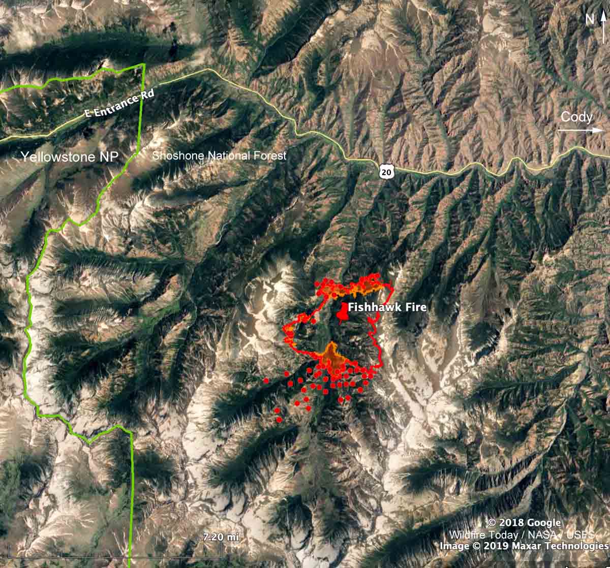
Map showing the location of the Fishhawk Fire. The red line was based on a USFS mapping flight at 8:19 p.m. MDT September 3, 2019. The red dots represent heat detected by a satellite at 2:12 p.m. MDT September 4, 2019.

The red dots on the map above represent heat detected on the Fishhawk Fire by a satellite at 2:12 p.m. MDT September 4, 2019. It is uncertain if they indicate actual surface spread of the fire toward the southwest, or if the heat was detected in an intense convection column in the atmosphere above the fire.

The smoke in the upper atmosphere was blowing off to the east, but perhaps lower level local winds, an up-canyon breeze, could have pushed the smoke and the fire to the south. During the fixed wing mapping flight at 8:19 p.m. on September 3 there was intense fire activity on the south edge of the fire.

(To see all articles on Wildfire Today about the Fishhawk Fire, including the most recent, click here.)

The Fishhawk Fire is 38 miles west of Cody, Wyoming, six miles east of the east entrance to Yellowstone National Park.

Scroll down to see more maps and information.


(UPDATED at 1:42 p.m. MDT September 4, 2019)

map Fishhawk Fire Cody Yellowstone
3-D map showing the location of the Fishhawk Fire at 8:19 p.m. MDT September 3, 2019, looking north.. Based on data collected from a USFS mapping aircraft. The orange shading indicates intense heat.

A mapping flight Tuesday night found that the Fishhawk Fire 38 miles west of Cody, Wyoming spread up to about one-quarter mile in all directions Tuesday except on the east side where it has reached a steep hog-back ridge 10,000 to 11,000 feet above sea level.

A Type 2 Incident Management Team will in-brief Wednesday prior to assuming command of the fire.

The resources assigned to the fire as of Tuesday evening included no hand crews, 3 engines, and 3 helicopters for a total of 29 personnel.

The 4,581-acre fire so far is confined to a north-south drainage that has a similar high elevation ridge on the west side. The fire is not being fully suppressed, so it is possible that firefighters are expecting the 10,000-foot ridges with light fuels to contain the perimeter on the east and west sides.

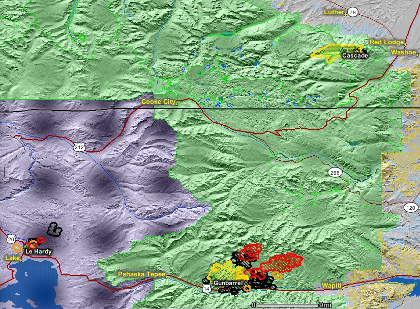
About 3.5 miles to the north is a highly-traveled highway, 14/16/20, leading from Cody to the east entrance of Yellowstone National Park. If it crosses the highway it would be burning on primarily south-facing slopes which would normally be very conducive to additional fire spread. However it would most likely be burning in the footprint of the 2008 Gunbarrel Fire that burned at least 67,000 acres. The light vegetation in the fire scar would present less resistance to control. Like the Fishhawk Fire, the Gunbarrel Fire was not suppressed. On August 15, 2008 the Shoshone National Forest had a plan for the maximum manageable area to cover 416,000 acres.
Map of the Gunbarrel Fire
Map of the Gunbarrel Fire (bottom-center) August 3, 2008. At the time it was about 22,000 acres. Map from Wildfire Today. Click to enlarge.

In their long term plans, fire managers on the Fishhawk Fire should plan for extreme winds. On August 28, 2008 the Powell Tribune wrote this about the Gunbarrel Fire :

“The winds are just howling,” Clint Dawson said Wednesday, describing the wind’s rate around the Gunbarrel Fire.

Dawson is the zone fire manager for Shoshone National Forest.

In the valley — in the vicinity of the newly-relocated Gunbarrel Fire camp at Buffalo Bill State Park — the wind was gusting to 40-60 mph in the early afternoon on Wednesday. The new incident command camp is just above the reservoir west of Cody.

An aircraft flying over the fire Wednesday reported winds reaching 115 mph at 11,000 feet, Dawson said.

The fire was spotting on the east side of 12,000-foot high Trout Peak, according to an incident report.

Continue reading “Fishhawk Fire grows to over 4,500 acres west of Cody, Wyoming”

Pedro Mountain Fire burns over 19,000 acres near Pathfinder Reservoir in Wyoming

Pedro Mountain Fire line construction
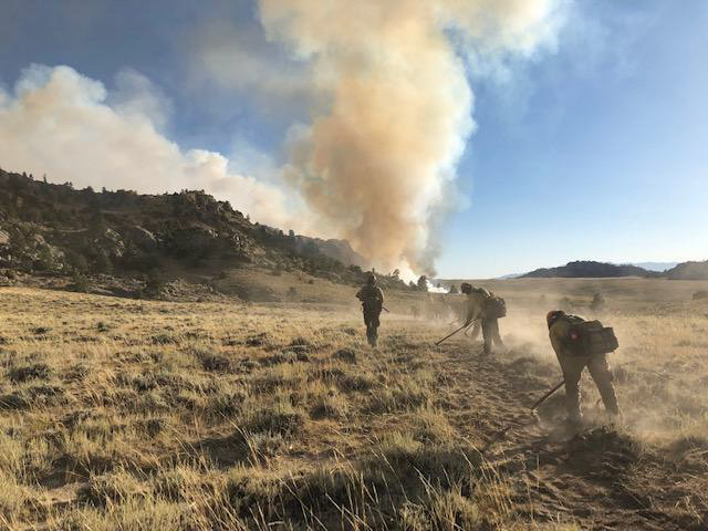
Firefighters construct fireline in preparation for burnout operations on August 28, 2019. Photo by Andrew Maue, Laramie Peak Fire Zone.

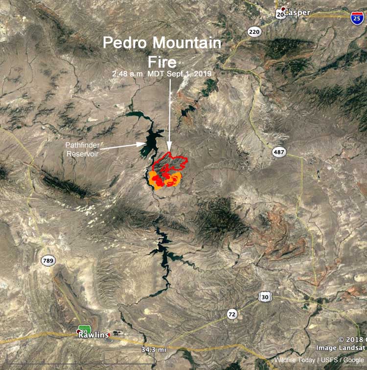
Since the Pedro Mountain Fire started from a lightning strike August 24 it has burned over 19,000 acres in southeast Wyoming. The fire is just east of the Pathfinder Reservoir, 37 miles northeast of Rawlins and 39 miles southwest of Casper. Evacuations are in effect for some areas.

From InciWeb:

Saturday’s Summary
Four hotshot crews, assisted by initial attack crews, completed a large and successful burn operation throughout the southern half of the fire on Saturday. The control line stretched for several miles, including Gooseberry Canyon and areas just west of Carbon County Road 291. This reduced the amount of vegetation in the fire’s path and is a key strategy in the effort to protect homes and property.

Sunday’s Operations
While some crews will continue working in the area of yesterday’s successful efforts in the south, other firefighters and engines will be rerouted to the northeast corner near Rocky Gap, where infrared flights show pockets of heat with the potential to spread to uncontrolled fire line. Fire prediction tools used by the incident management team show the fire has the most potential to spread to the east/northeast in the next 24 hours, based on weather and topography. Addressing these hot spots will limit significant fire growth and assist in closing up the containment line.

Crews are working under red flag warning conditions again today, with temperatures in the 90s, low humidity, and strong winds.

The evacuations and closures listed below remain in effect because firefighters are still engaged in efforts to stop the fire from spreading. With uncontrolled lines, the fire has potential to move to the east and south, putting fire and smoke closer to County Road 291. With well over 400 personnel on the fire, large numbers of crews and apparatus need to move unimpeded throughout the fire zone. The incident management team understands the public’s interest in returning to the area and will begin discussing plans with the Carbon County Sheriff’s Office to allow residents access to their homes and properties in a timely manner as soon as the area is safe from further fire spread and other impacts.

Map location Pedro Mountain Fire
Map showing the location of the Pedro Mountain Fire at 2:48 a.m. MDT September 1, 2019.

Closures / Public Safety
Evacuations are still in place for the following areas: Pedro Mountain Estates, Pedro Mountain Ranch Road, and Cardwell Ranch.

Natrona County Road 407 / Carbon County 291 (also known as Kortes Road) is closed from the intersection of Natrona County 408 (also known as Fremont Canyon) south to Leo/Sage Creek until further notice due to fire operations and public safety. The closure includes all roads west of the above location to Pathfinder Reservoir.

Sounds of a forest fire in Yellowstone National Park

Maple Fire
A scene from the Maple Fire in Yellowstone National Park, August 14, 2016.
National Park Service photo by Jennifer Jerrett.

The National Park Service recorded audio of flames spreading at the heel, or the back side, of the Maple Fire August 8, 2016 in Yellowstone National Park. Recorded from about 15 feet away, the fire activity was not extremely intense, but at about 14 seconds, you’ll hear a small clump of lodgepole pine trees burst into flames, or “torch.” In listening to the 60-second audio file below, you might want to turn up the volume.

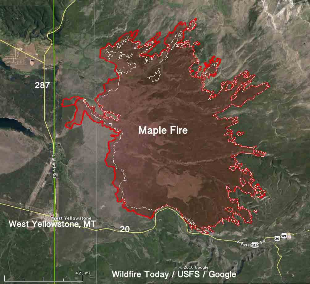
The Maple Fire burned over 40,000 acres northeast of West Yellowstone, Montana.

Maple Fire burns at Yellowstone National Park
The Maple Fire burns at Yellowstone National Park in 2016. The fire affected forests recovering from the park’s historic 1988 fires. National Park Service photo by Jennifer Jerrett. 
map Maple fire
The red line was the perimeter of the Maple Fire at 9 p.m. MDT Sept 2, 2016. The white line was the perimeter on August 29.

Articles on Wildfire Today tagged “Maple Fire”.

Lookout tower in Yellowstone burns

Mt Holmes lookout burned
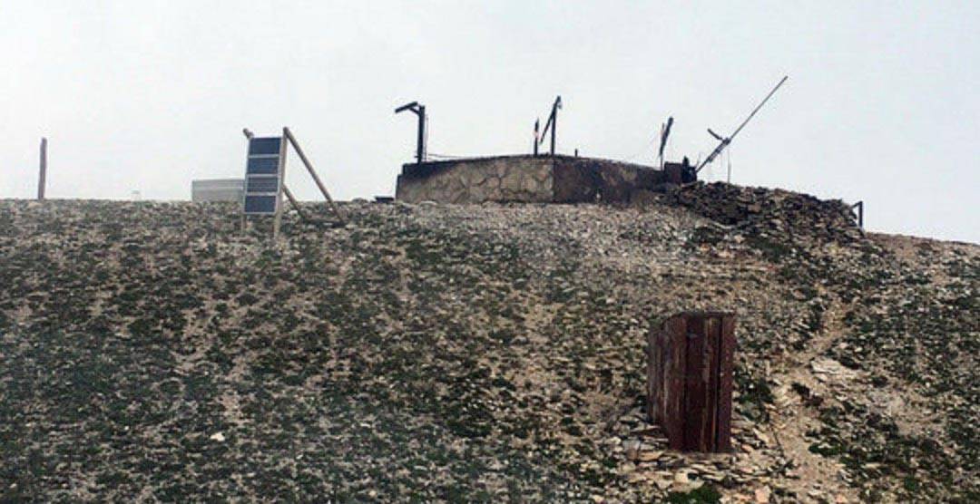
Mt. Holmes Lookout in Yellowstone National Park burned Tuesday, July 16, 2019. NPS photo.

The historic Mount Holmes Fire Lookout burned in Yellowstone National Park Tuesday after being struck by lightning. It had not been regularly staffed since 2007. The fire was reported Tuesday by the employee who staffs the Mount Washburn Fire Lookout.

The lookout is in the northwest corner of the park southwest of Mammoth Hot Springs.

Mt Holmes lookout
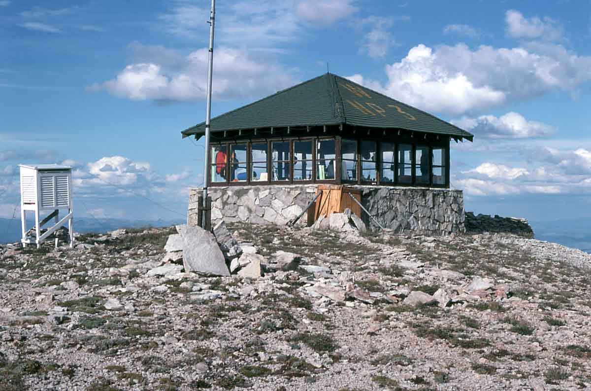
Mt Holmes lookout in 1975; NPS photo by RJK.

The structure fire also damaged a park radio repeater.

Wednesday morning, July 17, three employees including the park fire chief attempted to fly to the 10,000-foot lookout via helicopter to assess the damage. However, the flight was diverted to a higher priority incident outside the park. While en route, the helicopter manager snapped a photo of the burned lookout.
Wednesday afternoon, staff attempted to fly to the lookout again but were grounded due to strong winds. Additional attempts will be made in the next few days.

“Built in 1931, and renovated in 1998, the Mount Holmes Fire Lookout maintained its historic-era role as one of Yellowstone National Park’s staffed lookout stations until 2007″,said Yellowstone National Park Deputy Superintendent Pat Kenney. “The building was eligible for inclusion on the National Register of Historic Places, both for its significance in early park resource protection efforts, and as an outstanding example of the rustic architectural style that typified early park architecture. We are disappointed that this historic structure, as a window into the past, is gone.”

The Mount Washburn Fire Lookout is currently staffed seven days a week, mid-June through mid-September. If warranted, three additional lookouts can be staffed.

Thanks and a tip of the hat go out to Mr.Capt. Typos or errors, report them HERE.

Firefighters report “surprising” fire behavior in beetle-attacked lodgepole forests

surprising fire behavior beetle-attacked lodgepole forest fires
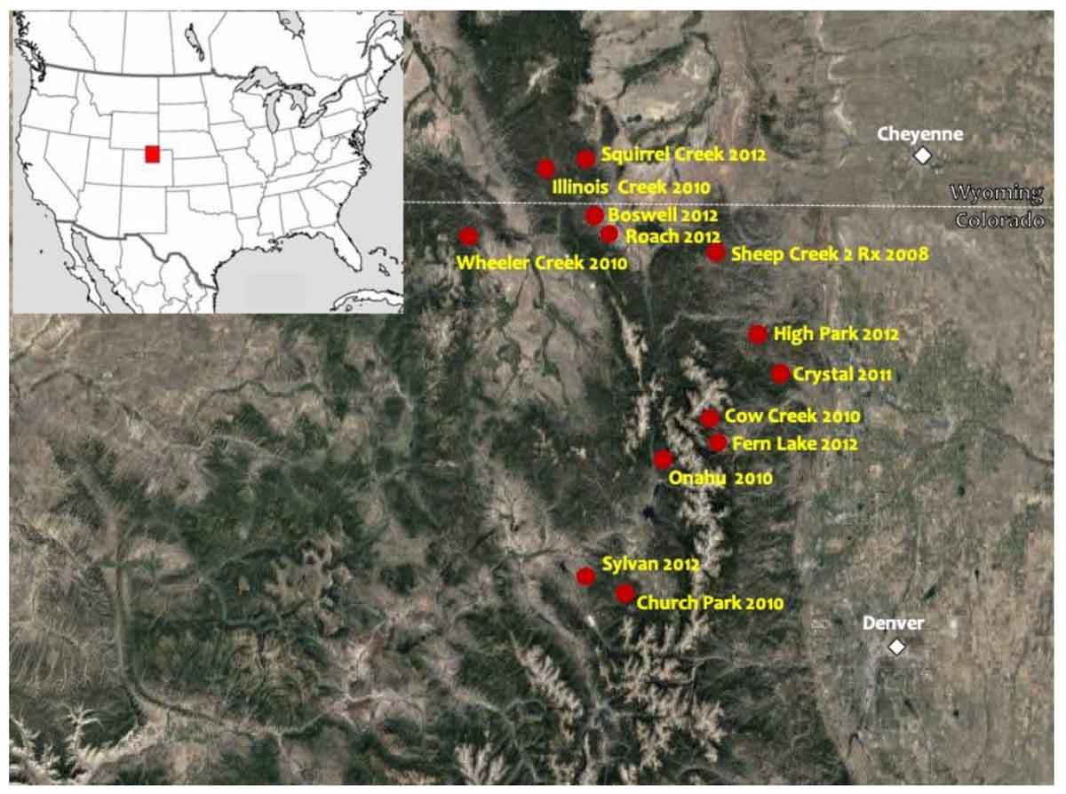
The researchers interviewed senior firefighters who worked on 13 wildfires in beetle-attacked areas of Northern Colorado and Southern Wyoming between 2010 and 2012. Image from the research. Click to enlarge.

In 28 interviews of experienced wildland firefighters of seven different agencies in Northern Colorado and Southern Wyoming researchers asked them about their observations of fire behavior in beetle-attacked lodgepole pine forests, with a focus on what they considered surprising from a fire behavior standpoint and how this in turn affected their suppression tactics. The interviews focused on 13 wildfires that occurred during the 2010 through 2012 fire seasons.

Below is an excerpt from a paper written by the researchers:

“The surprises in fire behavior experienced by firefighters during the red phase of post-outbreak forests included an elevated level of fire spread and intensity under moderate weather and fuel moisture conditions, increased spotting, and faster surface-to-crown fire transitions with limited or no ladder fuels.

“Unexpectedly, during the gray phase in mountain pine beetle-attacked stands, crown ignition and crown fire propagation was observed for short periods of time. Firefighters are now more likely to expect to see active fire behavior in nearly all fire weather and fuel moisture conditions, not just under critically dry and windy situations, and across all mountain pine beetle attack phases, not just the red phase. Firefighters changed their suppression tactics by adopting indirect methods due to the potential fire behavior and tree-fall hazards associated with mountain pine beetle-attacked lodgepole pine forests.”

Download the research paper (1 Mb)

Resilience of Yellowstone’s forests tested by unprecedented fire

In 2016 some areas in Yellowstone National Park that burned in the 1988 fires unexpectedly burned again, and with surprising intensity

Maple Fire burns at Yellowstone National Park
The Maple Fire burns at Yellowstone National Park in 2016. The fire affected forests recovering from the park’s historic 1988 fires. PHOTO: NATIONAL PARK SERVICE / JENNIFER JERRETT

By Kelly April Tyrrell, University of Wisconsin

In August 2016, areas of Yellowstone National Park that burned in 1988 burned again. Shortly after, in October 2016, ecologist Monica Turner and her team of graduate students visited the park to begin to assess the landscape.

“We saw these areas where everything was combusted and we hadn’t seen that previously,” says Turner, a professor of integrative biology at the University of Wisconsin–Madison who has closely studied Yellowstone’s response to fire since 1988. “That was surprising.”

In a study published this week [May 20, 2019] in the Proceedings of the National Academy of Sciences, Turner and her team describe what happens when Yellowstone —  adapted to recurring fires every 100 to 300 years — instead burns twice in fewer than 30 years. Yellowstone as we know it faces an uncertain future, the researchers say, and one of the big questions they hope to answer is whether the forests can recover.

yellowstone fires reburn
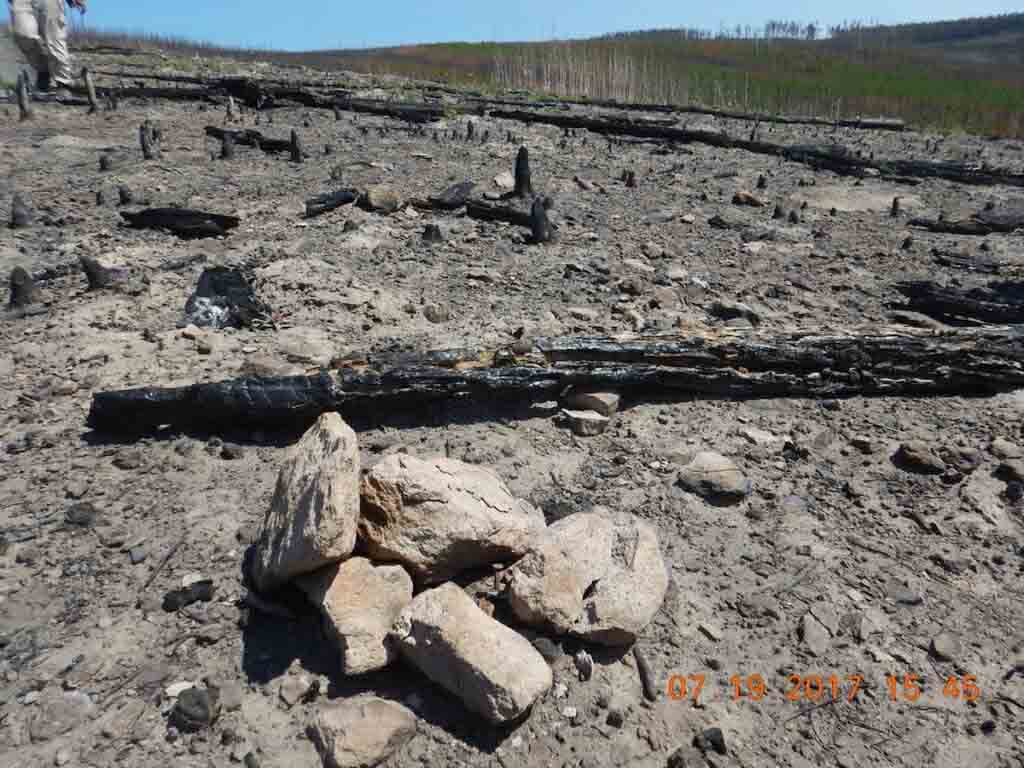
The pile of rocks with the nail in the middle signifies a long-term study plot Monica Turner and her research group established at Yellowstone National Park in 1990 following the park’s historic 1988 fires. This same plot burned again in 2016. Historically, fires burn in Yellowstone only every 100 to 300 years. PHOTO BY: MONICA TURNER

With Rapid Response Research funding from the National Science Foundation, Turner and her team returned to Yellowstone in the summer of 2017 to study the areas that re-burned. These include the Maple Fire, which burned 28-year-old lodgepole pines that regenerated following the 1988 North Fork Fire, and the Berry Fire, which contained 28-year-old lodgepole pines that had regenerated after the 1988 Huck Fire and 16-year-old trees that regenerated following the 2000 Glade Fire.

In each area, they compared to areas that burned in 1988 or 2000 but did not burn again in 2016.

Continue reading “Resilience of Yellowstone’s forests tested by unprecedented fire”