Forest Service intends to restore areas in Wyoming with logging, prescribed fire, and building roads

The project would take place in the Medicine Bow National Forest in southern Wyoming

Beaver Creek Fire intensity
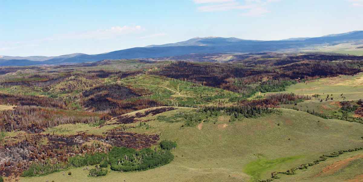
Varying burn intensities on the Beaver Creek Fire in the Medicine Bow-Routt NF in Colorado about 1 mile south of the Wyoming state line. The area had large areas of beetle-killed trees. July, 2016. InciWeb.

The U.S. Forest Service has a plan to treat 360,000 acres in the Medicine Bow National Forest in southern Wyoming by logging, thinning, prescribed burning, and building 600 miles of roads. The justification for what they are calling the Landscape Vegetation Analysis project, or LaVA, is to treat areas in the forest with the intention of “restoring forest health”. This area just north of the Colorado/ Wyoming border has been heavily impacted by Mountain Pine Beetles, so it fits the agency’s definition of an unhealthy forest and is considered by the U.S. Forest Service as an undesirable condition.
Landscape Vegetation Analysis project
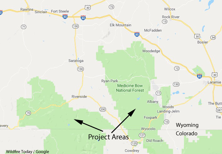
The areas in the Medicine Bow National Forest north of the Colorado line would be part of the Landscape Vegetation Analysis project.

The Forest Service intends to build 600 miles of roads, clear cut 95,000 acres, selectively cut or commercially thin 165,000 acres, and use prescribed fire, mastication, and hand thinning on 100,000 acres.

Climate change that brought drought and warmer weather has provided a better habitat for the beetles. During normal times their spread is inhibited in the higher elevations by cold winters. Several days with low temperatures of around 35 degrees below zero can knock them back, but if that does not occur the rice-sized insects can come back with a vengeance the next summer.

Beetle-killed trees can be hazardous to firefighters due to the possibility of falling trees and burning snags. And, 5 to 15 years after the outbreak heavy ground fuels make fireline construction difficult. The dead trees can also be problematic near roads, trails, and structures. But a couple of years after the beetle attack and the red needles have been shed, the tree skeletons are less prone to crown fires than green trees. In 2015 University of Colorado Boulder researcher Sarah Hart determined Western U.S. forests killed by the mountain pine beetle epidemic are no more at risk to burn than healthy Western forests. Other scientists have found similar results.

Below is an excerpt from the Washington Post:

Not everyone considers the plan a good idea. Some biologists say science doesn’t back up the efficacy of the treatments proposed, particularly logging and the prescribed burns that the Forest Service calls necessary for lodgepole pine to reproduce and more diverse species to take root.

“They say they are going to reduce fuel loads to limit wildfires, and the literature doesn’t support that,” said Daniel B. Tinker, an associate professor at the University of Wyoming, who has studied the region for 23 years. “We’ve had fires this summer that burned through areas that were clear-cut 15 years ago. Those stands weren’t supposed to burn for 100 years.”

Conservation groups also say the Forest Service truncated scientific review in a rush to meet congressional demands for increased timber production on public lands. For now, the proposal does not specify which parcels would be targeted and where those hundreds of miles of road would be built.

In the Washington Post, article Andy Stahl, executive director of Forest Service Employees for Environmental Ethics, was quoted as saying “Certainly, prescribed burning doesn’t pay its way — it’s expensive at around $100,000 per acre.”

If there is a prescribed fire somewhere that actually cost $100,000 an acre, which is very hard to believe, it is definitely an outlier. The costs vary greatly across the country and by vegetation type. They can be as inexpensive as less than a dollar an acre in Oklahoma, but usually run $10 to $250 an acre.

The federal agencies have had to cut back on their prescribed burning programs in recent years due to budget reductions.

The Forest Service expects to make a decision on the Medicine Bow plan in mid-2019.

Thanks and a tip of the hat go out to Gary.
Typos or errors, report them HERE.

Has Yellowstone “recovered” from the 1988 wildfires?

Yellowstone National Park 1988 wildfires
Yellowstone National Park fires in 1988. NPS.

We often hear about an area “recovering” from a wildfire. This implies that fire is unfortunate and unwelcome, a sentiment probably based on an instinctive fear. And it should go without saying — fires that burn structures or humans fit that description.

But vegetation fires in remote areas should be evaluated with different criteria. Yes, a fire can drastically change the appearance of a landscape. Most people visiting national parks, for example, would prefer to take pictures of a mature green forest than a recently burned hillside that is beginning a new fire return cycle. But those two ends of the cycle and everything in between are natural.

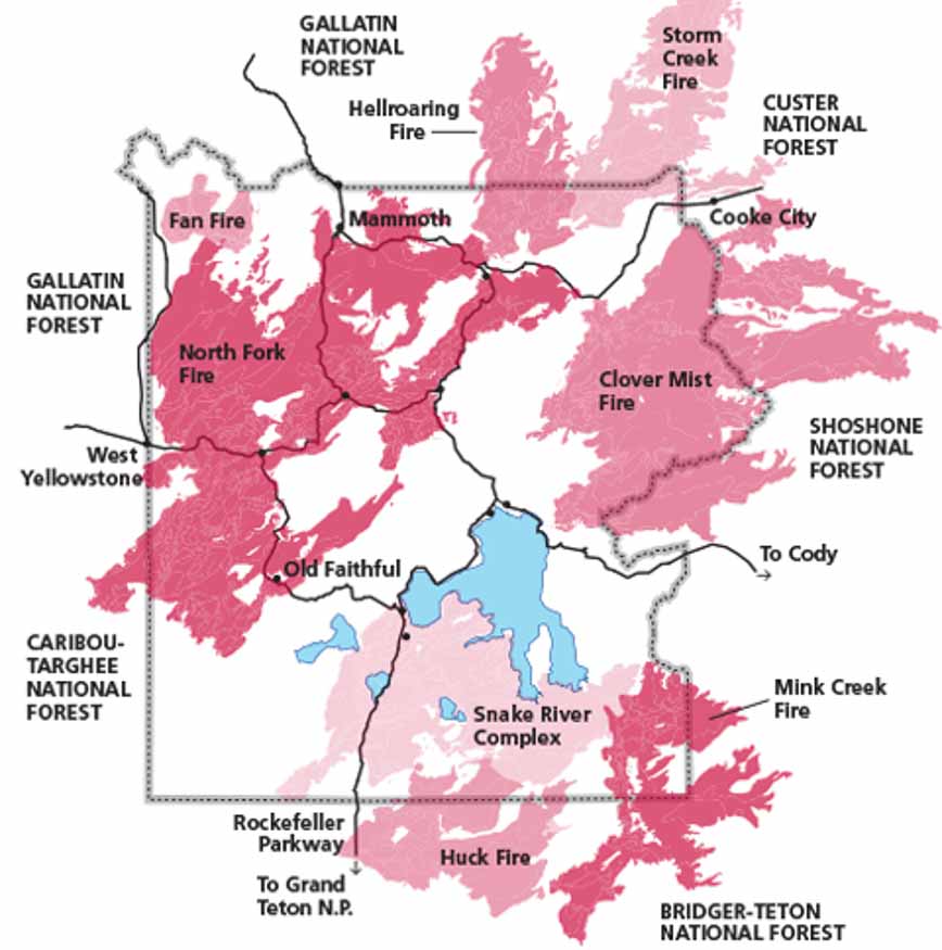
In 1988 fires in Yellowstone National Park caused mostly by lightning burned 793,880 acres, 36 percent of the park, during windy weather following a dry spring and summer. Today I saw an article that was focused on to what degree the vegetation had “recovered” from those fires 30 years ago. The emphasis was how much the landscape looked like it did before the fires of 1988. One might say that a lodgepole forest that burned at the end of its 50 to 300 year fire return interval had recovered the day after the embers cooled.

The photo below taken in 2003 in Yellowstone National Park in an area that burned in 1988 shows the regrowth of the forest in just 15 years.

yellowstone, thermal feature, trees,
Steam rises from a new Yellowstone National Park thermal feature in an area burned 15 years after the 1988 fires. The brown trees were killed by the sudden development of the high temperatures. Photo by Bill Gabbert, September 14, 2003.

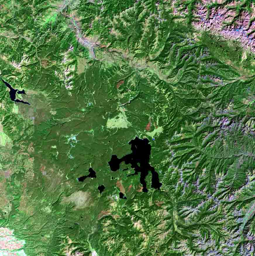
Below are satellite photos provided by the US Geological Survey of the Yellowstone area taken a year before, just after, and 30 years after the 1988 fires. The red areas are not the actual color of the vegetation, but represent the areas where the fires burned, as detected by shortwave infrared, near-infrared, and visible green sensors on a satellite. As the vegetation changes, light green areas start replacing the red and pink from the burn scar.

Yellowstone National Park 1988 wildfires
September 22, 1987

Continue reading “Has Yellowstone “recovered” from the 1988 wildfires?”

Firefighters making progress on Roosevelt Fire in Wyoming

Above: Roosevelt Fire, Wyoming. InciWeb photo. Date and photographer not identified.

Firefighters have accomplished a great deal on the Roosevelt Fire since it started September 15 south of Bondurant, Wyoming but it has grown to over 60,000 acres, and only about half of the 172-mile fire perimeter has completed fireline.

The focus Sunday was on the southwest side of the fire in the North Dry Beaver Creek area west of Jim Bridger Estates. Firefighters have secured fire lines there, which reduces the threat. Additional resources have been allocated and a structure protection group is working the area ahead of the fire to protect homes.

On the north side of the fire adjacent to the highway, containment lines are in place and holding the fire south of the highway.

In Hoback Ranches, recovery efforts are underway in preparation of an organized repopulation of residents. Lower Valley Energy and Rocky Mountain Energy are working to restore destroyed infrastructure, while firefighters are clearing dangerous snags and suppressing hotspots as they occur. These efforts will continue for a number of days until it is safe for residents to return.

Personnel on the fire could receive help Tuesday night through Wednesday with a 30 to 70 percent chance of precipitation. There could be as much as a quarter-inch on Tuesday. From Thursday until Sunday the chance of additional precipitation is from 20 to 60 percent. Nighttime temperatures will be in the 20s and 30s.

Investigators determined that the fire was caused by an abandoned warming fire.

Highway 191 is fully open through the fire area with reduced speed limits and lane restrictions.

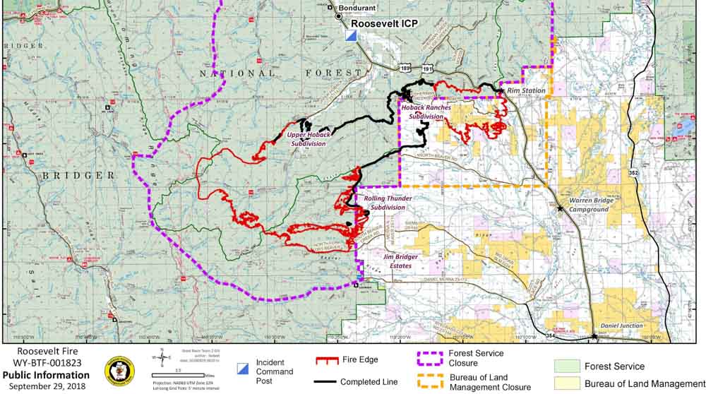
Map of the Roosevelt Fire
Map of the Roosevelt Fire, September 29, 2018. Click to enlarge.
Roosevelt Fire Wyoming
Roosevelt Fire. Photo by Kari Greer.
Roosevelt Fire Wyoming
A Firehawk helicopter executes a fancy water drop on the Roosevelt Fire in an area that is showing fall colors. Photo by Kari Greer.

Roosevelt Fire destroys at least 22 homes

The fire has burned over 50,000 acres 6 miles south of Bondurant, Wyoming

Above: A helicopter drops retardant near Rim Station on the Roosevelt Fire September 25, 2018. Inciweb photo.

After a survey Tuesday by the Sublette County Sheriff’s Office of 50 of the 153 homes in the Hoback Ranches subdivision, 22 were found to have been destroyed by the Roosevelt Fire. Property owners are being notified by the Sheriff’s Office. The fire is 6 miles south of Bondurant, Wyoming.

Wednesday while firefighters were conducting a burnout operation on the east side of the fire, Highway 189/191 was fully closed between Stinking Springs and Daniel Junction. The powerline along the highway has been shut down during the burnout, which affects the Kendall Valley and Upper Green areas.

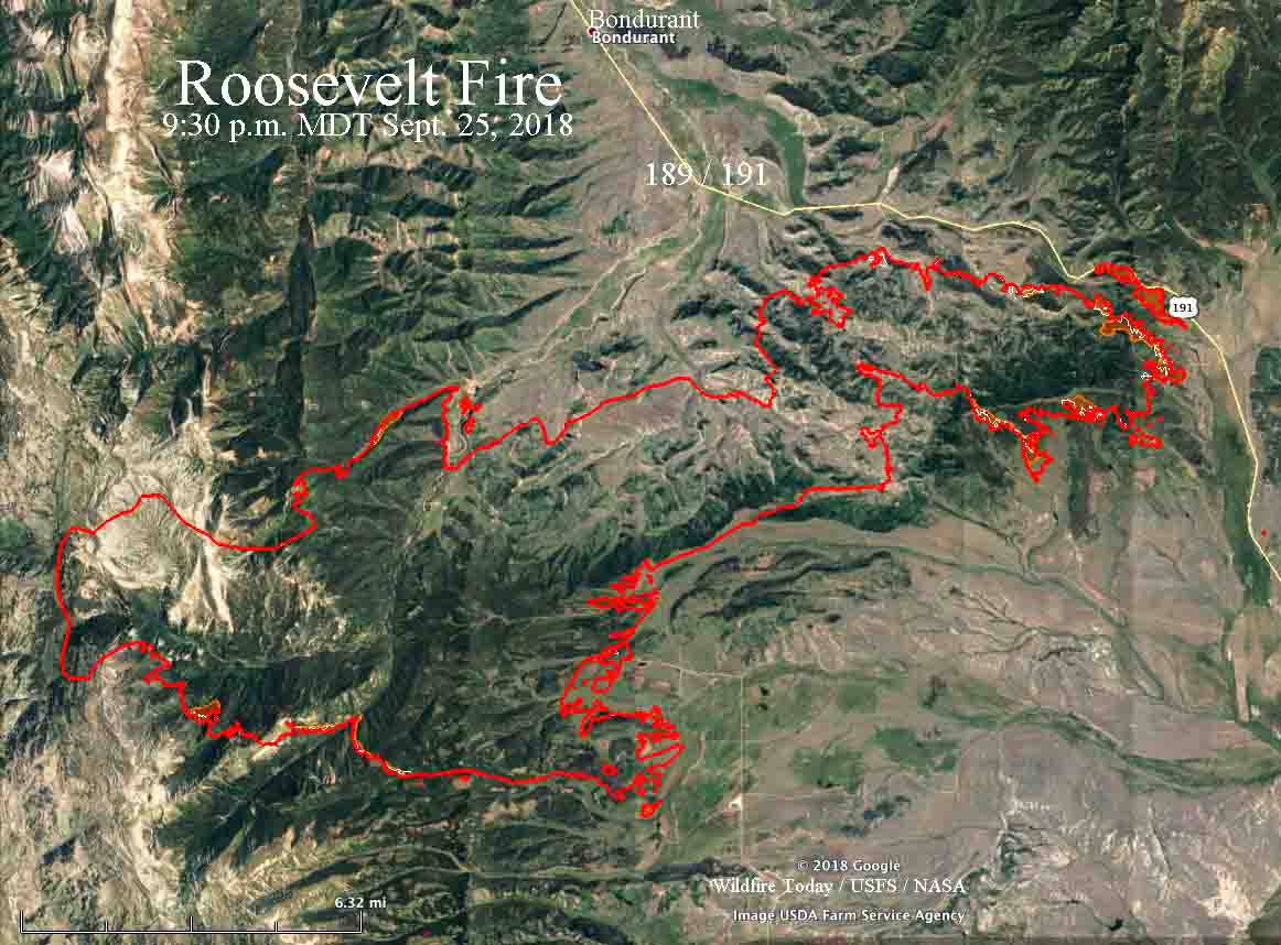
Map Roosevelt Fire wyoming
Map of the Roosevelt Fire. The red line was the perimeter at 9:30 p.m. MDT on September 25. The white line was the perimeter about 24 hours before. Click to enlarge.

On Tuesday the burnout near the highway was 2.2 miles long between Forest Road 30681 and Forest Lane.

Most of the significant growth on the fire Tuesday was on the east side within one to three miles of Highway 189/191. The rest of the fire exhibited low activity with no additional spread to the south, southeast, or west. In the area of Rolling Thunder, firefighters conducted burnout operations to further secure the fire edge. The fire did not move towards Jim Bridger Estates.

There was low fire intensity in the Upper Hoback and Kilgore Creek areas and firefighters continued to tie the open fire line into natural features to prevent fire movement east and west. In Hoback Ranches, firefighters knocked down hotspots to further secure homes in the area.

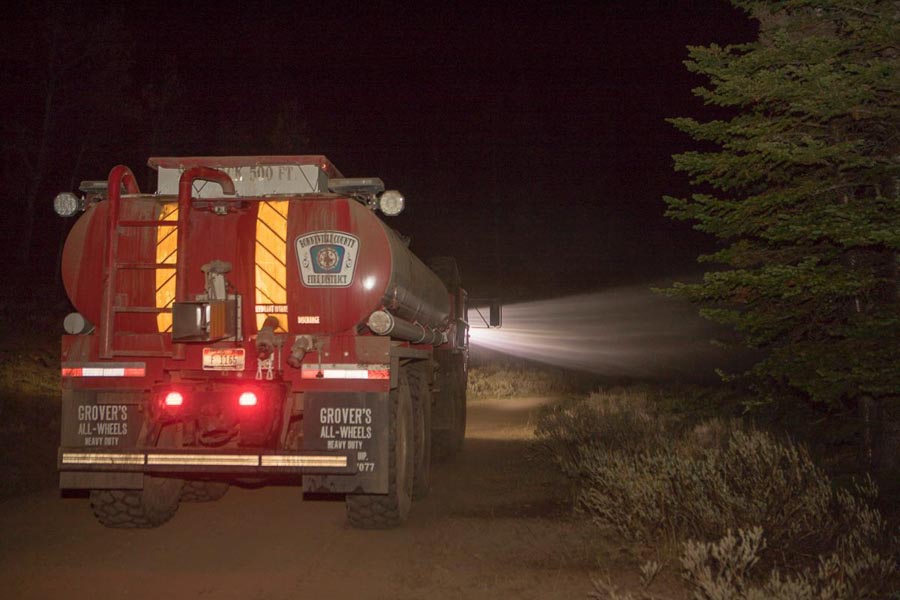
Resources assigned to the fire include 26 hand crews, 10 helicopters, 56 fire engines, 6 dozers, and 12 water tenders for a total of 982 personnel.

A Red Flag Warning is in effect in the area Wednesday for strong winds and dry fuels.

Roosevelt Fire approaches Highway 189/191

(UPDATED at 8:29 a.m. MDT September 25, 2018)

With the Roosevelt Fire approaching to within a quarter-mile of Highway 189/191 firefighters are again planning to conduct a burning operation on the southwest side of the road on Tuesday. They had hoped to start it Monday, but decided to postpone it.

The fire started September 15 and is 6 miles south of Bondurant, Wyoming.

Weather conditions Tuesday should be much more favorable than on Monday. After below freezing temperatures overnight, the forecast calls for 59 degrees, relative humidity in the teens, and west winds of 5 to 9 mph.

map Roosevelt Fire
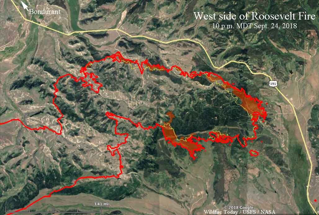
Map of the east side of the Roosevelt Fire. The red line was the perimeter at 10 p.m. MDT on September 24. The red shaded areas indicate intense heat. The white line was the perimeter about 24 hours before. Click to enlarge.

The fire grew by approximately 1,500 acres Monday to bring the total up to 49,805 acres. This was a smaller increase than in recent days, with most of the growth occurring on the east side where the perimeter roughly parallels Highway 189/191.


(Originally published at 6:27 p.m. MDT September 24, 2018)

Firefighters on the Roosevelt Fire 30 miles south of Jackson, Wyoming are attempting to fight fire with fire. Their goal Monday through Wednesday of this week is to use a backfire on the southwest side of Highway 189/191 to burn off the vegetation ahead of the fire, hoping it will serve as a barrier as the main fire spreads into the already burned vegetation.

On Monday it was a very difficult task, with 10 to 12 mph winds out of the west and northwest gusting at 20 to 26 mph. These conditions could increase the chance of spot fires across the highway from burning embers lofted by the strong winds.

map Roosevelt Fire
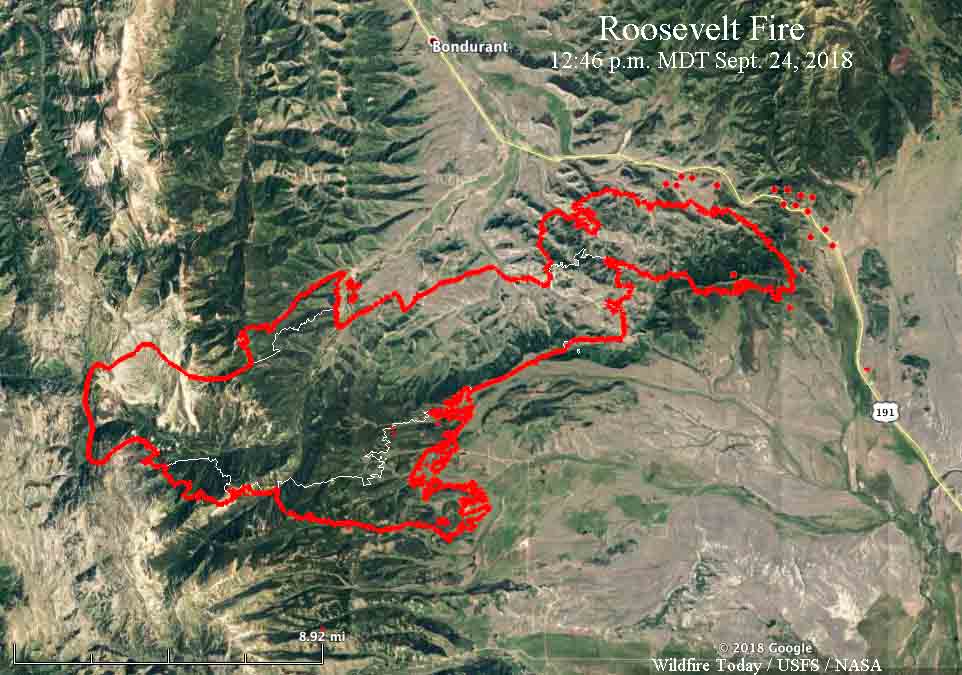
Map of the Roosevelt Fire. The red line was the perimeter at 9:20 p.m. MDT on September 23. The white line was the perimeter on Sept. 19. The red dots near Hwy. 189/191 represent heat detected by a satellite at 12:46 p.m. MDT September 24, 2018.

A Red Flag Warning is in effect for the area until 8 p.m. Monday. For Tuesday through Thursday the wind will decrease significantly. The temperatures will range from the teens at night to the 60’s during the day with little chance of precipitation. Those conditions should give firefighters a chance to make progress against the fire.

The fire is five miles south of Bondurant.

A mapping flight Sunday night at 9:20 determined that the fire had burned 48,348 acres.

Roosevelt Fire in western Wyoming grows to over 31,000 acres

One structure burned Wednesday night

(UPDATED at 4:31 MDT Sept. 20, 2018)

The 31,681-acre Roosevelt fire continued to burn aggressively into Wednesday night 30 miles south of Jackson, Wyoming. Most of the growth was on the south and east sides according to mapping conducted during the night. The fire is three miles from Highway 191 and six miles south of Bondurant.

Windy conditions Wednesday afternoon resulted in  numerous crown fire runs and occasional extreme rates of spread and flame lengths. One structure burned Wednesday night, but it was not specified if it was an outbuilding or residence.

map Roosevelt Fire Wyoming
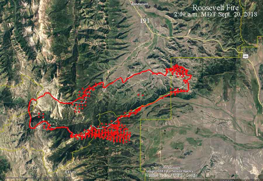
The red line was the perimeter of the Roosevelt Fire at 10:30 p.m. MDT September 19, 2018. The white line was the perimeter about 24 hours before. The red dots represent heat detected by a satellite at 2:40 a.m. MDT September 20.

Additional resources continue to arrive to assist the existing 259 personnel already on scene.

To see the all of the articles about the Roosevelt Fire on Wildfire Today, including the most recent, click HERE.

A Red Flag Warning is in effect Wednesday for relative humidity below 15 percent and afternoon winds from the west at 15 mph, gusting to 25 mph.

A update issued by the Incident Management Team September 20 stated “no injuries have occurred”. However on September 16 the Jackson Hole News & Guide reported that two civilians were seriously injured:

…They were caught in the area and forced to retreat into a creek. They were transported to St. John’s Medical Center, and as of Sunday night were being transferred to a burn center in Salt Lake City, according to a press release [Denise] Germann sent.

Ms. Germann was providing information about the fire for Grand Teton National Park and the Bridger-Teton National Forest.

When asked about injuries on the fire, Lorisa, a spokesperson for the Roosevelt Fire, said they are only reporting injuries that have occurred since the Incident Management Team presently in charge has been at the fire.

Thanks and a tip of the hat go out to Allen.
Typos or errors, report them HERE.