The fog of war

During the early stages of a wildfire, natural disaster, or battle, the information about the incident may be sparse, incorrect, or frequently changing as various sources provide the information as the incident evolves. The providers of the data, reporters or government personnel, may be viewing it from different vantage points, making assumptions, or they may filter it based on their own agenda.

The raid on the Osama bin Laden compound on Sunday is no exception. Over the course of the first two days, a broad range of highly variable information was distributed. Here is a sampling of what was reported by eight major media outlets. We gathered data for four categories: the number of helicopters involved, the number of U.S. soldiers involved, the height of the walls around bin Laden’s compound, and the description of the problem that led to the disabling of one of the helicopters.

No. of helicopters No. of U.S. soldiers Height of walls Disabled helicopter
Washington Post 2 and one backup 18’ mechanical failure
Associated Press 2 24 came crashing down, rolled on side
CNN 4 24 7’, 18’
ABC 4 25 15’, 17’
New York Times 3, 4 79 12 to 18’ stalled
MSNBC 4 24 12 to 18’ *density altitude, inadequate lift
Fox 2 40, 24 first “malfunctioned”, later *density altitude, inadequate lift
NPR 24+ 20’

*On May 3, MSNBC had an interesting and detailed explanation for the cause of the disabled or crashed helicopter. Basically, from their account, there was a density-altitude problem, but they did not use that term. The temperature was 17 degrees warmer than expected. The warmer, less dense air coupled with the high altitude and heavy load made it impossible for the helicopter to hover while the soldiers rappelled, and the aircraft made a hard landing. From other accounts, the helicopter may have hit its tail rotor on an object as it descended towards a hard landing, breaking it off. The soldiers later blew up the helicopter so that its sensitive electronic gear would not fall into the wrong hands. Fox news had a similar account.

Here is the report from MSNBC:

In Sunday’s mission, two Black Hawk helicopters were supposed to hover over the bin Laden compound and allow Navy special operations forces to rappel to the ground.

When one of the helicopters ran into problems — including temperatures that were 17 degrees higher than expected — and had to land abruptly, two Boeing Chinook helicopters were called in to help get the U.S. troops out, said one U.S. government official, speaking on condition of anonymity.

One Chinook would have sufficed, but a second one was sent in case that helicopter also ran into trouble, said Pike.

One retired military helicopter pilot said the Black Hawk likely ran into an issue called “settling with power,” when high temperatures, a heavy load and high altitudes force an unplanned landing. “Those conditions just suck the RPM out of the rotor,” he said.

Of course, all of these “facts” may be proven wrong in the weeks, months, and years to come.

One person killed, two injured on controlled burn in Nebraska

One person was killed and two others were critically burned while working on a controlled burn near Trenton, Nebraska (map) on April 28. A spokesman for the State Fire Marshall, Ray Nance, said none of the three were firefighters, but were “residents who fell victim to the fire” while they were clearing cattle grazing land. Nance said winds sent the fire out of control.

Here is more information from the McCook Daily Gazette, dated April 29, 2011:

TRENTON, Nebraska — A controlled burn on a rural farm northwest of Trenton, Nebraska, went horribly wrong late Thursday afternoon, resulting in the death of one and severe burn injuries to two others.

Hitchcock County Sheriff D. Bryan Leggott reported this morning that Theresa L. Borges Schnoor, 46 years old, of Trenton died at the fire scene eight miles northwest of Trenton.

Two Trenton men, 40-year-old Robert A. Seybold and 36-year-old Anthony P. Meguire were critically burned while assisting with the prescribed burn, and were transported to Community Hospital of McCook by Trenton ambulance. They were then flown to the Saint Elizabeth Regional Medical Center Burn Center in Lincoln.

This morning, both Seybold and Meguire were listed in critical condition.

Leggott said his office and the Nebraska State Fire Marshal’s office are conducting the investigation.

We offer our sincere condolences to the families and co-workers.

Hundreds of fires burn across Northern Ireland


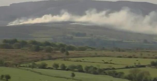
Northern Ireland fire
Northern Ireland fire. UTV

Hundreds of fires have been burning in Northern Ireleand over the last few days. Unseasonably dry weather, very strong winds, and a plague of arsonists have contributed to a situation that is unprecedented for that part of the world. A sampling of the reports includes descriptions such as “nine square miles” in the Torridon mountains, one fire that has burned 300 square kilometers (74,000 acres) west of Donegal, and 201 gorse fires on Sunday, and 282 gorse fires on Monday.


Helicopter dropping water in Northern Ireland
Helicopter dropping water on a gorse fire outside Pontoon, Co Mayo on May 2 in Northern Ireland. Eamonn Farrell/Photocall

The reporter below is dressed differently than reporters covering wildfires in the western United States, where they usually wear fire resistant clothing such as Nomex. But he gives a very interesting video report; check it out. Unfortunately, it can’t be embedded here.


Northern Ireland fire reporter
Northern Ireland fire reporter. Belfast Telegraph

Here is another video, the first few minutes of which are very interesting.

Seasoned wildland firefighters will enjoy this, from Irishtimes.com, a “new” way of fighting fire:

THE “MINIMAL” damage caused by gorse fires to property and forest in parts of the Cooley Peninsula was in part credited to a new way of tackling such fires by the senior assistant chief fire officer in Louth, Joe Lumsden.

The new method saw the fire service working with the Civil Defence and Coillte to create firebreaks. This involved cutting down some trees in advance of any fires to create openings in forest areas, and then soaking those pathways with water.

If a fire hits one of these firebreaks, it cannot continue any further, which both reduces the fire’s trajectory and makes the environment safer for firefighters.

Crews from Louth were trained in the new method by fire crews from the UK.

Wildfire potential, May through August, 2011

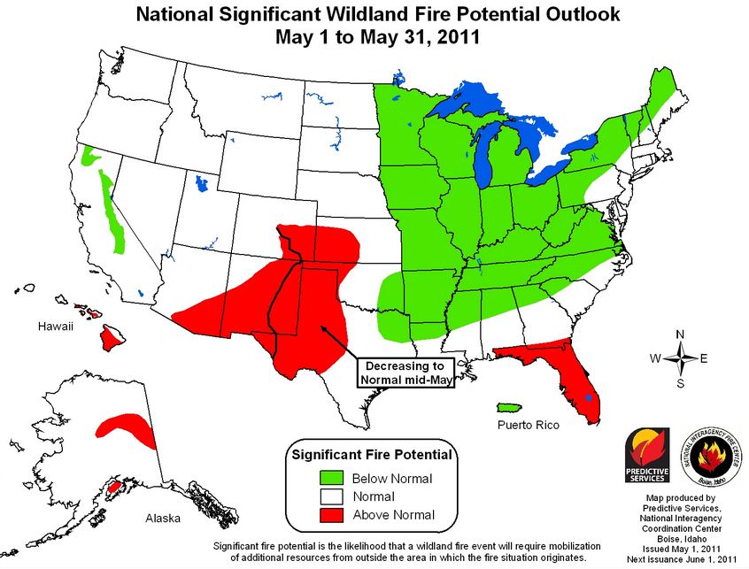
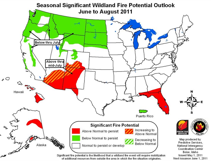
The Predictive Services section at the National Interagency Fire Center issued their National Wildland Significant Fire Potential Outlook for May through August, 2011. If this turns out to be accurate, it looks like it will be a quiet or average summer season for the United States, with the exception of portions of the southwest and Florida.

The primary factors influencing these outlooks are:

  • La Niña: The ongoing La Niña influence is forecast to weaken through early summer of 2011 and return to neutral conditions.
  • Drought: Drought will persist across portions of the southwestern U.S. with improvement expected over the southeastern U.S. and portions of Texas.
  • Fuel Dryness: Dryness observed over Florida and the extreme southeast states during spring will diminish by June. Unusually dry areas with above normal significant fire potential will expand westward and northward across New Mexico and Arizona through the summer while easing through much of Texas.

(Click on the images to see larger versions.)

National Wildfire outlook May 2011

National Wildfire outlook June-Aug 2011

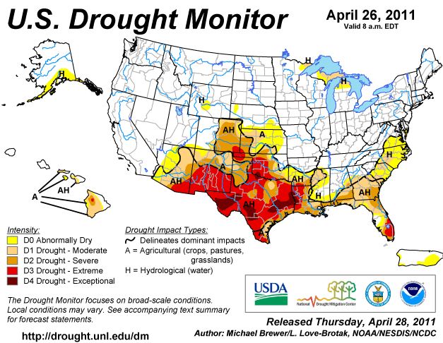
Here is the latest revision of the Drought Monitor released by the U.S. Department of Agriculture:

Drought Monitor 4-26-2011


Ecologist says needles of beetle-killed trees ignite faster than green needles

An ecologist working for the U.S. Forest Service says pine needles killed by a mountain pine beetle infestation ignite faster than green needles. Here is an excerpt from the Missoulian:

HELENA – The red needles of a tree killed in a mountain pine beetle attack can ignite up to three times faster than the green needles of a healthy tree, new research into the pine beetle epidemic has found.

The findings by U.S. Forest Service ecologist Matt Jolly are being used by fellow ecologist Russ Parsons to develop a new model that will eventually aid firefighters who battle blazes in the tens of millions of acres from Canada to Colorado where forest canopies have turned from green to red from the beetle outbreak.

The new model incorporates a level of detail and physics that doesn’t exist in current models, and it is much more advanced in predicting how a wildfire in a beetle-ravaged region will behave, Parsons said.

“It gives you so much more information about what to expect,” he said. “Are these people safe here or should they run away? If we put a crew on the ground here, can they make it to the top of the ridge in ample time?”

Many communities in the Rocky Mountain West have beetle kill forests in some proximity.

And the new research dispels the notion that beetle-killed trees present no greater fire danger than live ones, a theory that had gained traction after a couple of wet, cool summers tamped down fire activity in the region, Jolly said.

On the contrary, beetle-killed trees can hold 10 times less moisture than live trees, Jolly found. That means they not only ignite more quickly than live trees, but they burn more intensely and carry embers farther than live trees, Jolly said.

He found that it takes less heat for wildfires to spread from the ground to the crowns of beetle-killed trees, making a wildfire in a forest with beetle-killed trees potentially much more difficult to contain.

Mountain pine beetles also start losing their moisture before the needles change to that tell-tale red, Jolly said, meaning even a healthy-looking pine tree could pose an increased fire threat to an unsuspecting firefighter.

Jolly took more than 1,000 tree moisture content measurements and conducted hundreds of ignition tests last year in four states, using foliage from trees with red, yellow, orange and green needles.

Jolly and Parsons will present their research Wednesday in Helena at a seminar on wildfires and the mountain pine beetle held by the Montana Department of Natural Resources and Conservation. The seminar will also host researchers from the University of Idaho and British Columbia, where the beetle infestation covers an estimated 43 million acres, which is more than 67,000 square miles.

So far this is information presented by a reporter. It will be interesting to read the actual findings of Mr. Jolly’s study. The article does not say what species of trees was involved in the study nor does it describe the ignition tests.

Research on lodgepole pines in the Greater Yellowstone area has yielded this information:

Modeling results suggested that undisturbed, red, and gray-stage stands were unlikely to exhibit transition of surface fires to tree crowns (torching), and that the likelihood of sustaining an active crown fire (crowning) decreased from undisturbed to gray-stage stands. Simulated fire behavior was little affected by beetle disturbance when wind speed was either below 40 km/h or above 60 km/h, but at intermediate wind speeds, probability of crowning in red- and gray-stage stands was lower than in undisturbed stands, and old post-outbreak stands were predicted to have passive crown fires. Results were consistent across a range of fuel moisture scenarios. Our results suggest that mountain pine beetle outbreaks in Greater Yellowstone may reduce the probability of active crown fire in the short term by thinning lodgepole pine canopies.

Wildfire Today has written frequently about the effects of pine beetles on wildfire.

More information about the May 4, 2011 forum “Mountain Pine Beetle and Fire which will be broadcast live on the internet.

Thanks Dick

Update on the international Bull fire


Firefighter monitors for lingering flames on the Bull fire
Firefighter monitors for lingering flames on the Bull fire. Photo: Eastern Arizona IMTeam

Firefighters have made unprecedented progress on the Bull fire, which started in Mexico on Friday April 29, and soon crossed the international border coming to within a few miles of Nogales, Arizona. A news release issued Saturday by the Coronado National Forest said the fire had burned a total of 23,000 acres, with 11,000 of those acres being on the U.S. side of the border. Sunday’s 8:00 a.m. news release from the same source reduced that acreage to an “estimated” 8,700. It did not specify the number of acres burned on each side of the border. (An update on InciWeb Sunday night clarified that a total of 24,000 acres had burned, with 9,711 acres being blackened on the U.S. side of the border.)

Here is more information from the Sunday news release:

General Information:

The Eastern Arizona Type 2 Incident Management Team assumed command of the Bull Fire at 6 p.m. on Saturday. The Incident Command Post is located at Calabases County Park, Santa Cruz County, AZ.   The fire is currently burning on lands administered by the Coronado National Forest within the Nogales Ranger District.

Fire Activity: Extreme fire behavior and long-range spotting during gusty wind conditions have been observed. Currently the fire is backing down slope into the wind and wind-driven fire in some drainages is also occurring. Flame lengths are 5 to 10 feet.

Significant Events: Personnel who worked through the night on Friday, conducted burnout operations halting the fire’s northern movement. Today, firefighters will continue to hold and secure firelines, extinguish hot spots close to the edge of the fireline and respond to new fire starts in the area.

The map of the Bull fire, below, shows heat detected by satellites on May 1, 2011.

Bull Fire map 5-1-2011
Bull Fire map, showing heat detected by satellites on 5-1-2011. MODIS/USFS