New real time mapping system used on Cave Fire

Fire Integrated Real-Time Intelligence System (FIRIS)
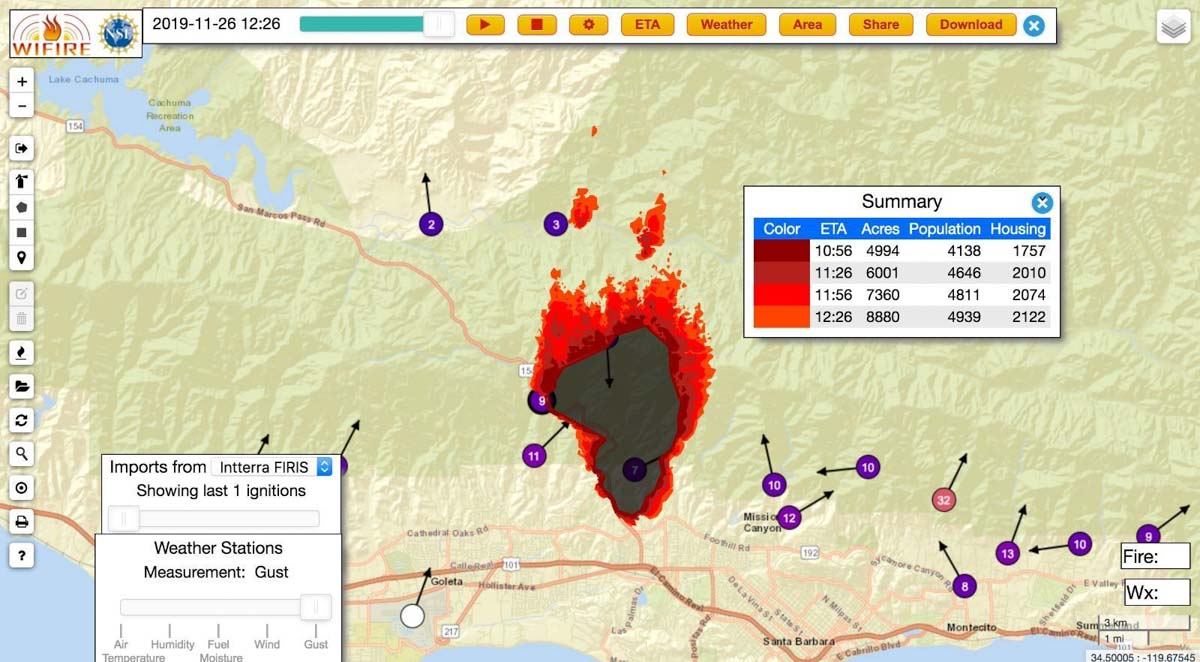
An example of an output from the Fire Integrated Real-Time Intelligence System (FIRIS) used on the Cave Fire near Santa Barbara, CA November 26, 2019. The dots with arrows represent weather stations. Inciweb.

A new real time wildfire mapping system was used on the Cave Fire near Santa Barbara, California this week.

In September the Orange County Fire Authority began a 150-day pilot program to use and evaluate the Fire Integrated Real-Time Intelligence System (FIRIS). The program got off the ground thanks to funding secured in the 2019-2020 California state budget by Assemblywoman Cottie Petrie-Norris (D-Laguna Beach).

The system utilizes a fixed-wing aircraft equipped with infrared and radar sensors that can see through smoke. The plane provides real-time fire perimeter mapping and live high definition video to support supercomputer-based wildfire predictive spread modeling.

(Click here to see all articles on the Cave Fire, including the most recent)

FIRIS fire wildfire mapping real time
Screenshot of aircraft featured in the FIRIS B-Roll video.

A supercomputer at the University of California San Diego runs WIFIRE spread projections based on fire perimeter data collected by the aircraft. The output estimates where the fire will be in the next six hours. The fire spread model adjusts for successful fire suppression actions by firefighters on the ground and in the air. This intel allows for more timely and accurate decision making for resource allocation and evacuations.
flight path N4717V fire mapping
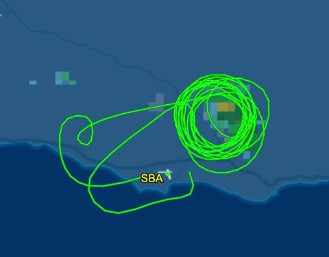
The flight path of N4717V, a Turbo Commander 690, also known as “AC90”. It was orbiting over the Cave Fire at 12,400 feet on November 26, 2019. Flightaware map.
AC90 mapping aircraft wildfire
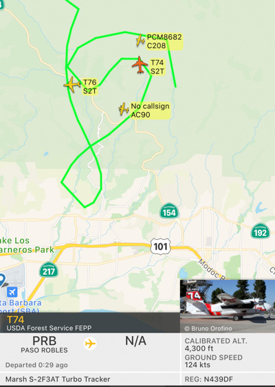
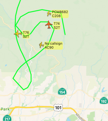
The FIRIS aircraft, shown as “AC90”, was over the Cave Fire along with two S-2T air tankers, at 7:52 a.m. November 26, 2019. Flightradar24

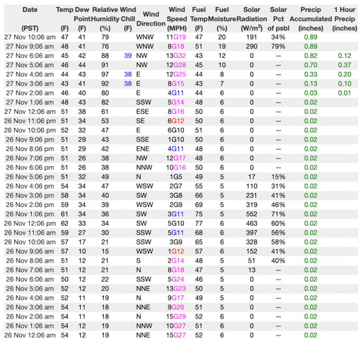
If I am correctly interpreting the WIFIRE product at the top of this article the system predicted that the Cave Fire would grow from 4,994 to 8,880 acres over a 90-minute period beginning at 10:56 a.m. on November 26, 2019. Spot fires were predicted more than a mile ahead. However, decreasing winds that day slowed the spread. A weather station in San Marcos Pass about three miles northwest of the fire recorded sustained wind speeds from 1 to 5 mph between 10 a.m. and 5 p.m. Rain beginning at 2 a.m. November 27 stopped  the spread at 4,330 acres.
Weather San Marcos Pass
Weather at San Marcos Pass, November 26-27, 2019.

The video below is “B-Roll”, that is, unedited footage of the FIRIS system. The first 6.5 minutes are simply images of aircraft, but after that you will be able to look over the shoulder of the imagery technician as he observes infrared imagery of a fire, manually interprets the heat signatures, then traces the fire perimeter on the screen. That perimeter could then be electronically sent to the super computer in San Diego County which would run a fire spread model to predict what the fire will do in the next six hours.

Our attempts to obtain more information about FIRIS from personnel on the Cave Fire that used the system were not successful.

Rain aids containment of Cave Fire

Evacuees could be back in their homes by the end of the day Wednesday

map Cave Fire November 26 2019
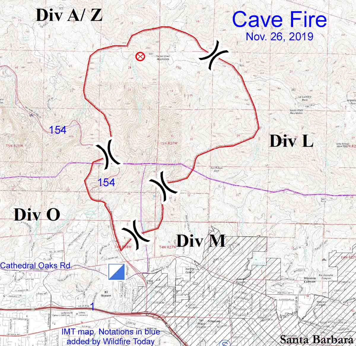
Map of the Cave Fire, November 26, 2019. Produced by the incident management team. Notations in blue by Wildfire Today.

10:01 a.m. PST November 27, 2019

The predicted rain that would stop the spread of the Cave Fire near Santa Barbara arrived at 2 a.m. Wednesday, four hours after it was expected, but by 9 a.m. had accumulated 0.87 inch in the weather station in San Marcos Pass. An additional 1.3″ through Thursday night is in the forecast.

Mike Eliason, an Information Officer for Santa Barbara County Fire Department, said Wednesday morning that there is a slight chance of snow in the higher elevations of the fire. The lowest edge of the fire at Santa Barbara is at 300 feet, but the ridge near the north side rises to 3,500 feet.

(Click here to see all articles on the Cave Fire, including the most recent)

Plans to repopulate evacuated areas are under evaluation. Mr. Eliason said everyone should be back in their homes by the end of the day on Wednesday.

The latest mapping puts the fire at 4,330 acres. There are still residual smokes visible and Highway 154, with fire on both sides, remains closed. Demobilization of firefighters will begin today.

Well over 90 percent of the fire is on land managed by the Los Padres National Forest, but the suppression was carried out by a unified command also representing Santa Barbara County and CAL FIRE.

Rainbow Cave Fire
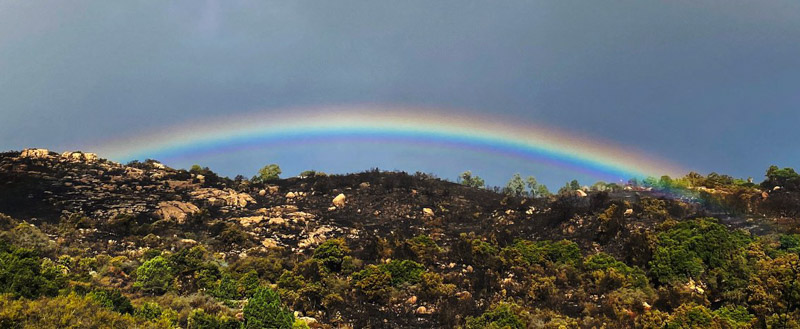
Rainbow over the Cave Fire near Painted Cave Road Wednesday morning. Mike Eliason photo for SBCFD.

Cave Fire near Santa Barbara burns thousands of acres, forcing evacuations

The fire started Monday afternoon, pushed by strong winds

map Cave Fire Santa Barbara
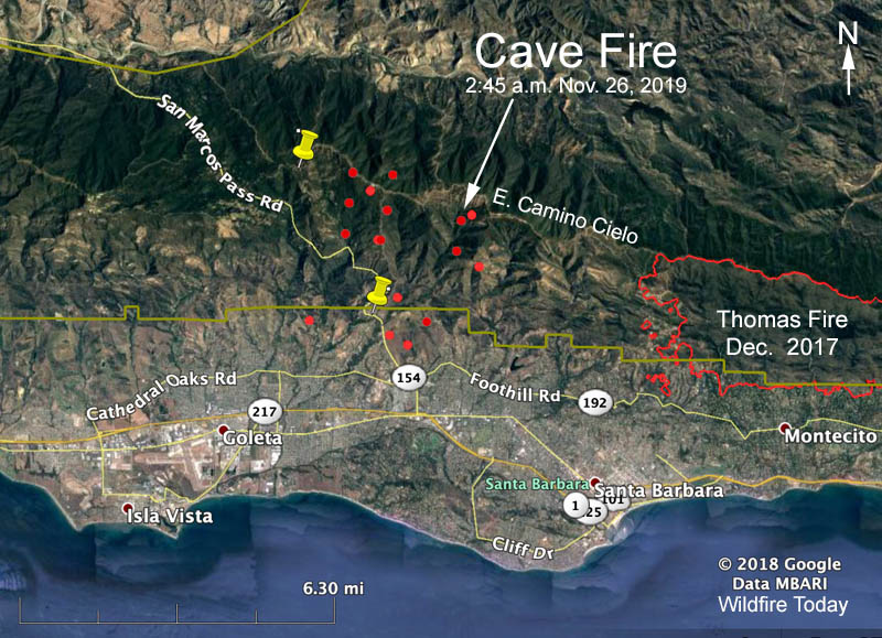
The red dots represent heat on the Cave Fire detected by a satellite at 2:45 a.m. PST Nov. 26, 2019.

UPDATED at 1:55 p.m. PST November 26, 2019

At an 11 a.m. press conference Tuesday fire authorities said the Cave Fire at Santa Barbara, California had burned 4,262 acres. In addition to the 10 air tankers and 9 helicopters, 500 firefighters are working on the blaze.

The strong wind that drove the fire rapidly downhill toward the city Monday night slowed on Tuesday. Rain is expected to begin at about 10 p.m. Tuesday, but forecasters have backed off the two inches that was predicted through Thursday, cutting it in half, to about one inch. There is a chance of more rain this weekend.

(Click here to see all articles on the Cave Fire, including the most recent)


Updated at 8:01 a.m. PST Nov. 26, 2019

The spread of the Cave Fire northwest of Santa Barbara, California slowed after midnight Monday night but it continued to grow actively near Painted Cave Road and had burned into the San Marcos Foothills Nature Preserve just north of the city limits of Santa Barbara.

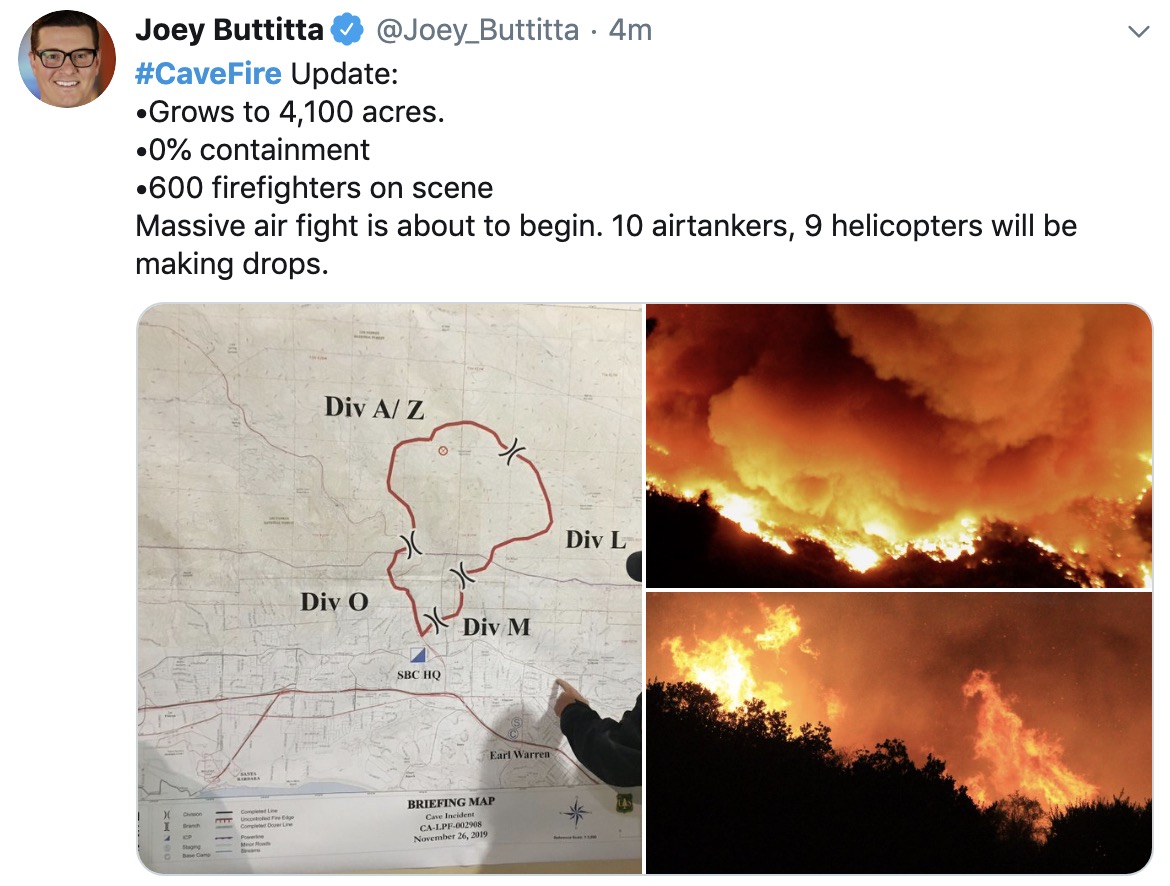
At 7:34 a.m. PST Mike Eliason of the Santa Barbara County Fire Department reported, “4,100 acres with 0% containment. 600 firefighters assigned. No structures (homes) destroyed & no injuries.”

In the map above the red dots represent heat detected by a satellite orbiting 500 miles above the earth. The locations have not been confirmed by individuals closer to the ground. We expect to obtain slightly more accurate satellite data later Tuesday morning.

map Cave Fire Santa Barbara
Posted by Joey Buttitta of Fox 11 at 7:38 a.m. Nov. 26, 2019.
aircraft cave fire over
Aircraft over the fire at 7:52 a.m. included two S-2T airtankers and an air attack ship.
Cave Fire November 25, 2019
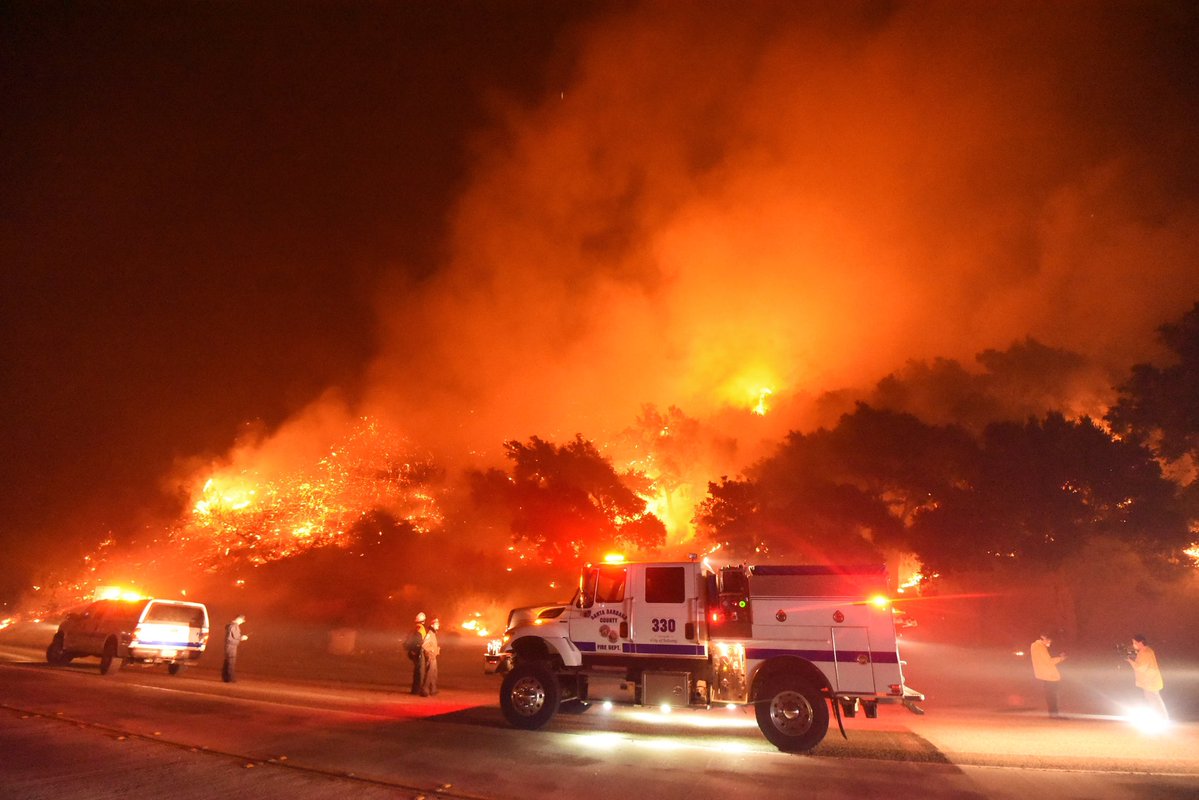
“#CaveFire- FF’s from Santa Barbara County Fire battle flames off CA Hwy-154 north of Santa Barbara Monday night,” wrote Mike Eliason of the Santa Barbara County FD who took this photo Monday night.

Originally published at 10:40 p.m. PST November 25, 2019

Firefighters are working to protect structures threatened by the Cave Fire that spread rapidly after it started northwest of Santa Barbara, California at 4 p.m. Monday. It was pushed by winds out of the north that increased from 5 mph to 16 mph, with gusts up to 30. At sunset a nearby weather station in San Marcos Pass recorded a temperature of 61 degrees with 16 percent relative humidity.

Continue reading “Cave Fire near Santa Barbara burns thousands of acres, forcing evacuations”

BLM all-female fire camp in Oregon

This year, 25 women attended the two-weekend camp

BLM's all-female fire camp
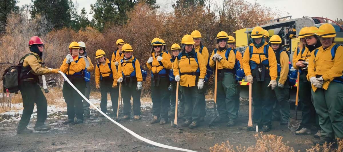
Students at the BLM’s all-female fire camp in Oregon. Screenshot from the BLM video below.

From the Bureau of Land Management:

Students came from all over the country for this year’s BLM’s all-female wildfire camp in eastern Oregon.

For the class final, the all-female crew of wildfire students dug fire line, rolled hose, and burned slash piles in the eastern Oregon snow.

The live burn exercise was the climax of the second annual Women in Wildland Fire Boot Camp, a BLM recruitment and retention tool that organizers hope will add diversity to the applicant pool for wildfire jobs.

The boot camp is really a paid training opportunity, part classroom and part field work, for women to become certified for federal fire jobs, an industry long dominated by men.

“I think we’re acknowledging we need to add diversity to our workforce,” said Jeff Fedrizzi, the top BLM fire official for Oregon and Washington, “And we’re putting our money where our mouth is.”

Twenty women attended last year and more than half of that first class ended up getting a job in firefighting, said Cassandra Andrews-Fleckenstein, the BLM program manager for the camp. This year, 25 women attended the two-weekend camp, once again coming from across the country. Students slept outside in 10-degree weather, used portable toilets, and wore the classic wildland firefighter uniform of yellow shirt and green pants, just like any other fire camp.

Kathleen Mascarenas, who is studying forestry and fire science at Colorado State University, said she came to the Women in Wildland Fire Boot Camp to get her foot in the door for a future job.

“I really just wanted to get a hands-on experience,” said Mascarenas, as a controlled burn crackled behind her last month. “I thought it would be a great experience to get started and meet some of the women that I would be hopefully working with in the future,” she said.

One of the attendees from Oregon, Kelli Creekmore, said she recently got her emergency medical technician license and is hoping to get a job providing first aid to wildland firefighters.

In addition to the typical fire coursework, students also received special presentations, for example, what it is like to be pregnant during a wildfire pack test, and how to successfully apply via USAJobs.gov.

Since many of the camp attendees are coming in with advanced education and other valuable prerequisites, it is imperative that they become fluent in the federal hiring process, said camp manager Andrews-Fleckenstein.

“They are frustrated because they don’t really know how to get into these fire jobs,” said Andrews-Fleckenstein, listing the main gripe she heard from students at the camp. “I’m finding that this camp is kind of a bridge for them.”

Bob Narus, the fire manager for the BLM’s Vale District, an area that spans more than 5 million acres in eastern Oregon, said simply making more applicants aware that the BLM is an option for firefighting jobs is important.

“I think there’s value in having these women in wildfire camps, so more people can become aware that, ‘Hey, I can go fight fire with the BLM also, not just the Forest Service,’” said Narus.

While camp attendees are compensated for their time, they are not reimbursed for their travel to and from rural eastern Oregon. Last year, one student flew round-trip from Chicago between university midterms to attend the boot camp, said Andrews-Fleckenstein, noting the clear and unique value of the all-female BLM fire camp.

“I think if we had more of them across the country, or offered a couple more, you might get a lot of people coming into it,” she said.


— by Toshio Suzuki, tsuzuki@blm.gov

Red Flag Warning to be followed by snow in Owens Valley

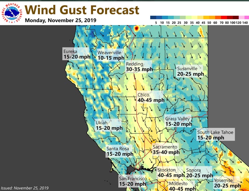
It will also be very windy in Northern California

Red Flag Warning Sierras
Red Flag Warning issued at 1:57 a.m. PST Nov. 25, 2019. NWS.

8:24 a.m. PST November 25, 2019

Strong north winds gusting up to 50 mph in the Southern Sierras on Monday with humidity in the low teens has generated a Red Flag Warning for Owens Valley. The wind behind a cold front is expected to reach Bishop, California around 10 a.m. and then spread down to the rest of the valley by noon, continuing into the early evening before gusts decrease to less than 35 mph.

It will also be very windy in Northern California on Monday but no Red Flag Warnings have been issued for that part of the state as of 8:15 a.m. Monday.

strong wind forecast northern california

The enhanced wildfire danger will be followed by a winter storm warning from late Tuesday afternoon through Friday morning. Significant snow accumulations are predicted for much of Inyo County, the southern Great Basin, and higher elevations of the Mojave Desert. Forecasters expect total snow accumulations of five to 10 inches in the Owens Valley and 12 to 36 inches in the mountains, with winds gusting up to 45 mph.

(Red Flag Warnings can be modified throughout the day as NWS offices around the country update and revise their weather forecasts.)

Massive bushfires in Australia have made the koala “functionally extinct”

Over 1,000 koalas have been killed and 80 percent of their habitat has burned

The recent large bushfires in New South Wales have killed more than 1,000 koalas and burned 80 percent of their habitat, according to Deborah Tabart, chair of the Australian Koala Foundation.

From Forbes.com:

Recent bushfires, along with prolonged drought and deforestation has led to koalas becoming “functionally extinct” according to experts.

Functional extinction is when a population becomes so limited that they no longer play a significant role in their ecosystem and the population becomes no longer viable. While some individuals could produce, the limited number of koalas makes the long-term viability of the species unlikely and highly susceptible to disease.

Deforestation and bushfires destroy the main nutrient source of koalas, the eucalyptus tree. An adult koala will eat up to 2 pounds of eucalyptus leaves per day as it’s main staple of nutrients. While eucalyptus plants will grow back after a fire, it will take months, leaving no suitable food source for koalas and starvation a likely scenario for many.

There is a movement in Australia for the government to pass a bill that was introduced in 2016 but never passed. The Koala Protection Act would protect habitats and reduce or prevent hunting of the animals.

The screenshot at the top of this article is from a video showing a woman rescuing the badly injured koala. Click here to see it, but some may find it disturbing.

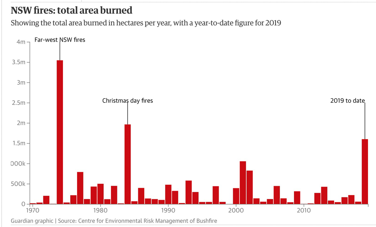
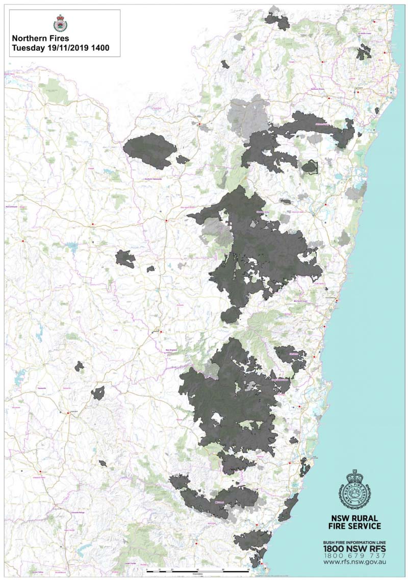
The New South Wales Rural Fire Service stated on November 19 that the perimeter of the fires in their state so far this fire season was over 6,000 kilometers (3,728 miles). Six people have died, 600 homes have been destroyed, 1.65 million hectares (4.1 million acres) have burned, and the season is not even halfway over. The acres burned to date in 2019 is the third highest annual total since 1970.

acres burned NSW 1970-2019
Guardian
map fires new south wales
Map showing recent bushfires in New South Wales, November 19, 2019.