New real time mapping system used on Cave Fire

Fire Integrated Real-Time Intelligence System (FIRIS)
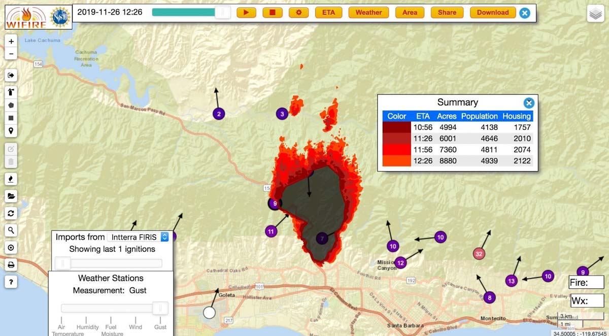
An example of an output from the Fire Integrated Real-Time Intelligence System (FIRIS) used on the Cave Fire near Santa Barbara, CA November 26, 2019. The dots with arrows represent weather stations. Inciweb.

A new real time wildfire mapping system was used on the Cave Fire near Santa Barbara, California this week.

In September the Orange County Fire Authority began a 150-day pilot program to use and evaluate the Fire Integrated Real-Time Intelligence System (FIRIS). The program got off the ground thanks to funding secured in the 2019-2020 California state budget by Assemblywoman Cottie Petrie-Norris (D-Laguna Beach).

The system utilizes a fixed-wing aircraft equipped with infrared and radar sensors that can see through smoke. The plane provides real-time fire perimeter mapping and live high definition video to support supercomputer-based wildfire predictive spread modeling.

(Click here to see all articles on the Cave Fire, including the most recent)

FIRIS fire wildfire mapping real time
Screenshot of aircraft featured in the FIRIS B-Roll video.

A supercomputer at the University of California San Diego runs WIFIRE spread projections based on fire perimeter data collected by the aircraft. The output estimates where the fire will be in the next six hours. The fire spread model adjusts for successful fire suppression actions by firefighters on the ground and in the air. This intel allows for more timely and accurate decision making for resource allocation and evacuations.
flight path N4717V fire mapping
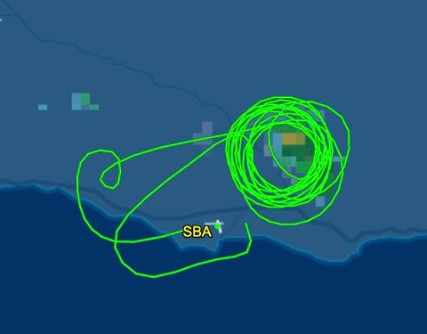
The flight path of N4717V, a Turbo Commander 690, also known as “AC90”. It was orbiting over the Cave Fire at 12,400 feet on November 26, 2019. Flightaware map.
AC90 mapping aircraft wildfire
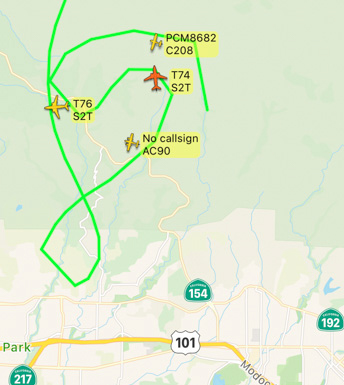
The FIRIS aircraft, shown as “AC90”, was over the Cave Fire along with two S-2T air tankers, at 7:52 a.m. November 26, 2019. Flightradar24

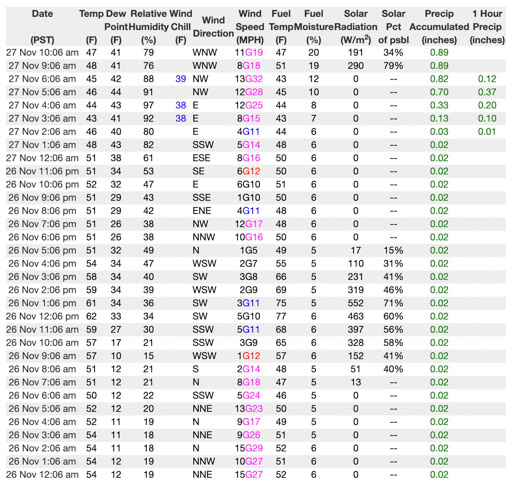
If I am correctly interpreting the WIFIRE product at the top of this article the system predicted that the Cave Fire would grow from 4,994 to 8,880 acres over a 90-minute period beginning at 10:56 a.m. on November 26, 2019. Spot fires were predicted more than a mile ahead. However, decreasing winds that day slowed the spread. A weather station in San Marcos Pass about three miles northwest of the fire recorded sustained wind speeds from 1 to 5 mph between 10 a.m. and 5 p.m. Rain beginning at 2 a.m. November 27 stopped  the spread at 4,330 acres.
Weather San Marcos Pass
Weather at San Marcos Pass, November 26-27, 2019.

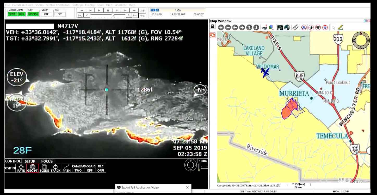
The video below is “B-Roll”, that is, unedited footage of the FIRIS system. The first 6.5 minutes are simply images of aircraft, but after that you will be able to look over the shoulder of the imagery technician as he observes infrared imagery of a fire, manually interprets the heat signatures, then traces the fire perimeter on the screen. That perimeter could then be electronically sent to the super computer in San Diego County which would run a fire spread model to predict what the fire will do in the next six hours.

Our attempts to obtain more information about FIRIS from personnel on the Cave Fire that used the system were not successful.

Orange County introduces pilot program for real time wildfire mapping

It is another step toward the Holy Grail of Wildland Firefighter Safety

FIRIS fire wildfire mapping real time
An example of the technician’s screen when using the FIRIS system. Screenshot from the video below.

This month the Orange County Fire Authority began a 150-day pilot program that could lead to real time fire mapping being available to firefighters on the ground. Not knowing exactly where a fire is has been a factor in more than two dozen firefighter fatalities in recent decades. Smoke, terrain, and darkness can obstruct the view of fire crews and supervisors which can severely compromise their situational awareness.

The 150-day Fire Integrated Real-Time Intelligence System (FIRIS) pilot program got off the ground September 1 thanks to funding secured in the 2019-2020 California state budget by Assemblywoman Cottie Petrie-Norris (D-Laguna Beach).

“The State of California must shift strategies to address the constant crisis of wildfires – this is no longer a seasonal threat,” stated Assemblywoman Petrie-Norris. “I am proud to have partnered with the Orange County Fire Authority in securing $4.5 million in state funds for technology that will protect lives and property by giving first responders better, stronger tools to use against the threat of wildfires.”

The system utilizes a fixed-wing aircraft equipped with infrared and radar sensors that can see through smoke. The plane provides real-time fire perimeter mapping and live high definition video to support supercomputer-based wildfire predictive spread modeling.

FIRIS fire wildfire mapping real time
Screenshot of aircraft featured in the FIRIS B-Roll video.

A supercomputer at the University of California San Diego will run fire spread projections based on fire perimeter data collected by the aircraft. The output will estimate where the fire will be in the next six hours. The fire spread model will adjust for successful fire suppression actions by firefighters on the ground and in the air. This intel allows for more timely and accurate decision making for resource allocation and evacuations.

“The ability to place resources exactly where they need to be to successfully battle a wildfire can mean the difference between lives and property saved or lost”, said Orange County Fire Authority Fire Chief Brian Fennessy. “Technology is becoming increasingly important as we work to suppress wildfires quickly. We’re hopeful this pilot program may someday become a routine asset statewide.”

For decision-makers on the ground, a common operating picture increases situational awareness. Firefighters on the front line, incident commanders, law enforcement, and regional and state emergency operation centers all could have the ability to see the same fire intel on a smartphone, tablet or computer in real-time. Fire perimeter maps and live video feeds are provided through an electronic network to assist decision-makers.

This is another step toward the Holy Grail of Wildland Firefighter Safety which would ultimately provide to fire supervisors the real time location of a fire and the location of firefighting personnel and equipment.

The video below is “B-Roll”, that is, unedited footage. The first 6.5 minutes are simply images of aircraft, but after that you will be able to look over the shoulder of the imagery technician as he observes infrared imagery of a fire, manually interprets the heat signatures, then traces the fire perimeter on the screen. That perimeter could then be electronically sent to the super computer in San Diego County which would run a fire spread model to predict what the fire will do in the next six hours.

USFS to buy thousands of satellite emergency notification devices

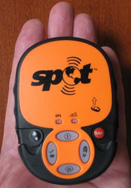
SPOT
Example of a Satellite Emergency Notification Device. Photo by Bill Gabbert

The U.S. Forest Service has issued a solicitation indicating that they intend to purchase thousands of Satellite Emergency Notification Devices (SEND). The specifications listed by the USFS require that the device be able to:

  • Determine location using GPS.
  • Send via satellite an emergency message containing the device’s location after pressing an “SOS” button. A monitoring facility would then notify a nearby emergency services agency.
  • Track location by sending the device’s location via satellite every 10 minutes, minimum, if activated by pressing the TRACK button.
  • Display the tracked locations on a map on the internet.
  • Send a pre-programmed HELP message including the device’s location.
  • Send a “check-in” message, including the location, after pressing a “check-in” button.

I have used one of these for years. In fact, the photo is my “SPOT Satellite GPS Messenger“, which is a second generation SPOT device. I always carry mine when I am on an extended motorcycle trip, or sometimes on a 4-wheeled vehicle trip. The two features that I like best about it are the SOS which works via satellite even when there is no cell phone service, and the tracking feature so that my family or friends can know where I am. If I’m running late, they can check the map on the web site and know that I’m still on the road and moving… or not.

On the solicitation the USFS says they want the devices because:

Forest Service employees routinely work in the wilderness. Their main mean of communication while in the wilderness is 2 way radios. Normally the employees use mobile and handheld radios to communicate their locations and status to the dispatch center. Approximately 20% of the forest is outside of the area of coverage of radios because of terrains.

It will be interesting to find out if they can use this device to track multiple wildfire suppression resources on one map. Will a dispatcher be able to see where all of their engines and crews are? Could it even be displayed on a smart phone? Will an Incident Commander or Branch Director have access to a map that shows where their firefighting resources are? This could add an element of safety. At times like this I think of the Esperanza fire, and wonder if it would have made a difference if the Operations Section Chief or Division Supervisor had had maps in front of them that displayed the location of Engine 57 at the top of that drainage before the fire overran their location. Could five lives have been saved?

Actually, using this little portable device for mass resource tracking is a half-assed approach, rather than putting professional-quality location-tracking devices in all wildfire suppression rolling stock and radios…like many professional-quality fire departments, police departments, and ambulance services have been doing for years.

I am not entirely fluent in translating contracting-speak into English, but it appears that the USFS has $1.2 million burning a hole in their pocket and they want to use all of it over the course of one year to buy as many devices as they can, to include a year of service — monitoring, mapping, and satellite messaging. A SPOT Personal Tracker is listed for $60 to $170 on Google, and a year of service costs $99. There are other brands out there with different pricing. The government would no doubt get a deal if they buy a few thousand, so picking some numbers out of the air, if they pay a total of $120 per device for a year, that would be 10,000 units. WOW. Even if they pay retail at Best Buy for a SPOT device, on sale now for $60, then pay retail for service, $99, that’s 7,500 of the little things.

Here is another excerpt from the USFS solicitation:

4.3 Minimum delivery requirements shall be 1,000 units 30 days ARO; 3,000 units (or the balance of the total) 60 days ARO; 5,000 units (or the balance of the total) 90 days ARO; and the balance 120 days ARO.

This technology is evolving rapidly, and since the SPOT is on sale at Best Buy, maybe the company is about to introduce a third generation device. DeLorme has an inReach device that can apparently do most if not all that a SPOT can do, but can also send AND receive text messages… anywhere. It’s a little pricey, costing several times more than a SPOT.

UPDATE, January 14, 2014: The U.S. Forest Service bought 6,000 of the devices. There is a discussion of them in the report of an ATV accident that occurred on the Schoolhouse Fire in New Mexico in 2013.


Thanks go out to Robert