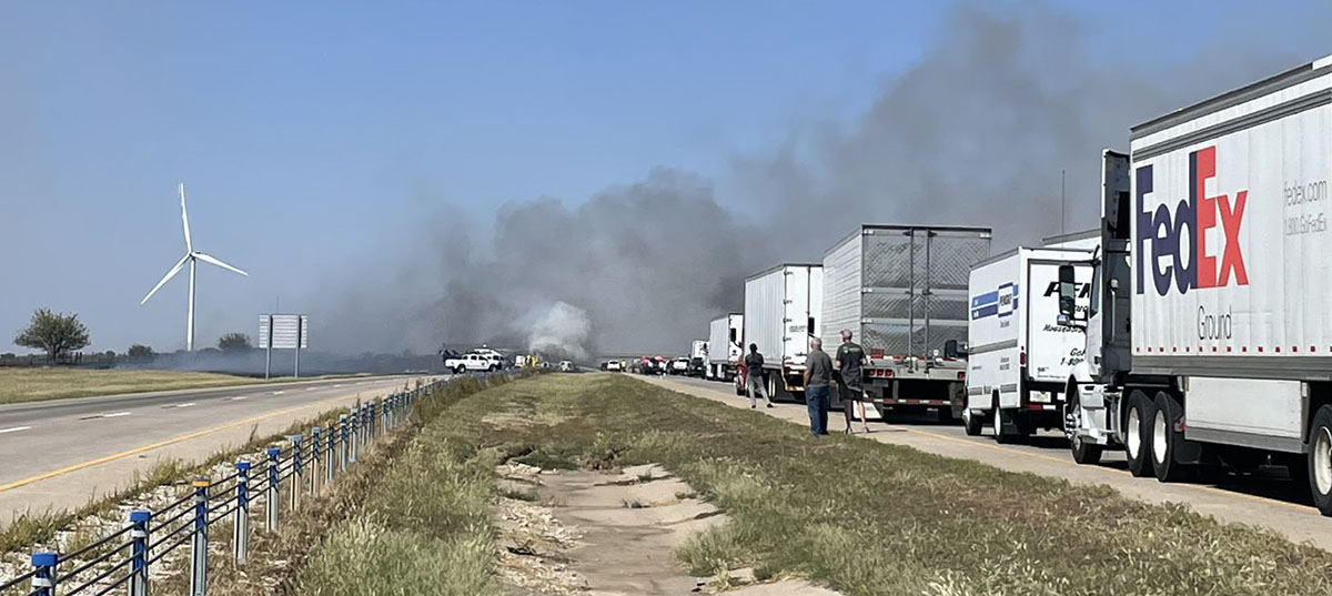
Crash and a grass fire close I-35 in Oklahoma, Sept. 27, 2022. Oklahoma Highway Patrol photo.
Interstate 35 in Noble County, Oklahoma Tuesday was closed for hours following a multiple vehicle crash in which at least one person died. Aerial footage showed fires in the rubble of mangled semi trucks and other vehicles. A nearby grass fire burned up to the Interstate and authorities suspect smoke from the fire reduced the visibility that led to the crash.
The Oklahoma Highway Patrol said the highway was completely shut down southbound at mile marker 211 and northbound at mile marker 203.
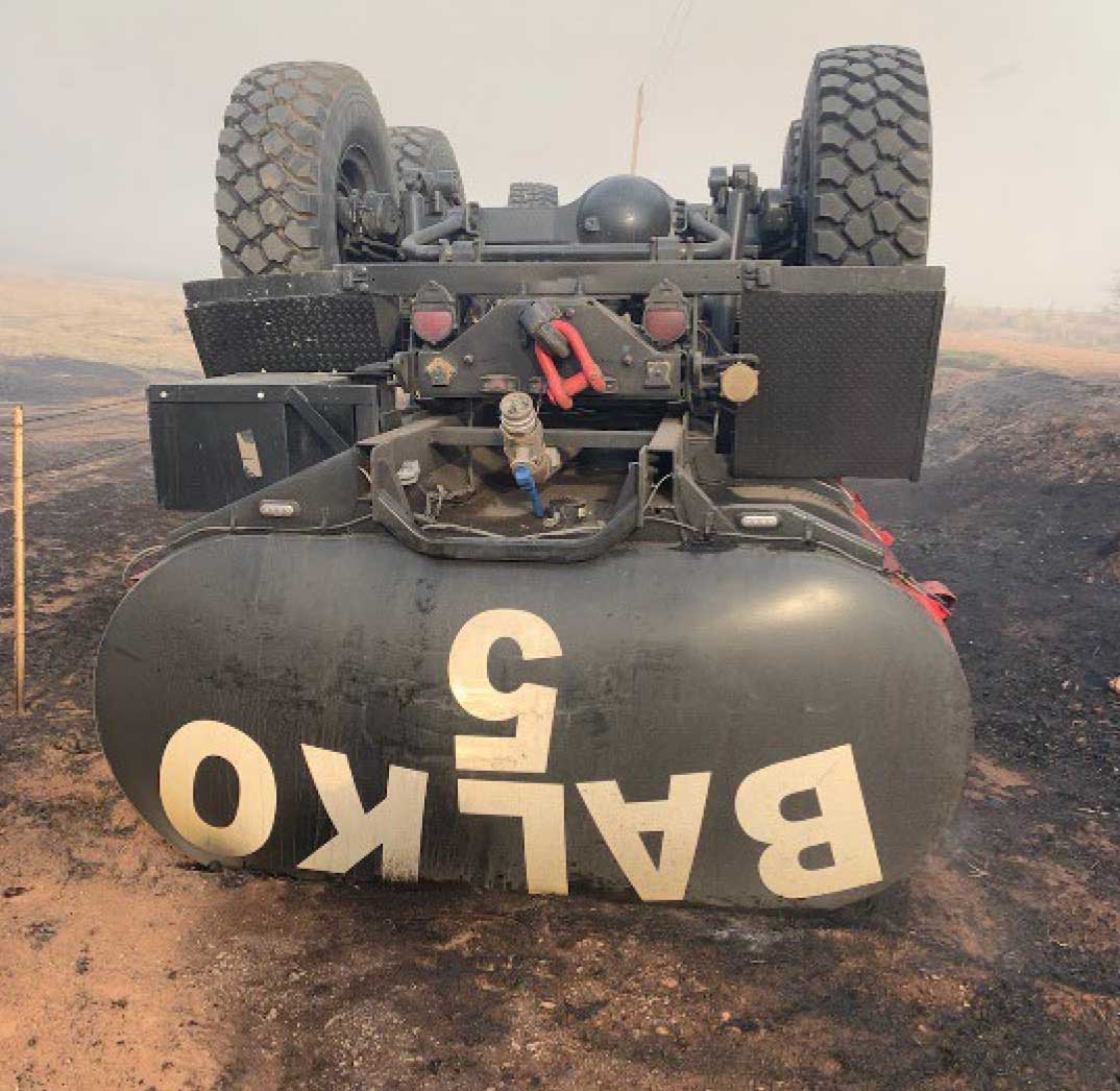
Rollover of Balko FD Engine 5 — Oklahoma, April 6, 2022. Photo courtesy of OK Forestry Services.
Updated at 8:30 p.m. CDT May 9, 2022
Just a few hours after we saw the notice from the Wildland Fire Lessons Learned Center and wrote the piece below about the rollover of an engine in Oklahoma on April 5, Mark informed us that one of the two injured firefighters, Jason Smith, passed away yesterday from his injuries.
Below is an excerpt from a Facebook post by Western Oklahoma Fire Coverage on May 8:
In memory of fallen Firefighter Jason Smith with the Balko Fire department. Just 33 days ago, while fighting the Beaver River Fire in Beaver County, two Balko firefighters were injured when their truck rolled over off of a 6’ embankment. They were flown to Lubbock, TX to the burn unit to receive treatment. Jason was finally able to come home at the end of last month, but today he lost the battle and succumbed to his injuries. Jason leaves behind his wife, 2 daughters and a 3 1/2 month old grandson Emmett that he was very proud of.
We send our sincere condolences to the family, friends, and co-workers of Mr. Smith.
5:08 p.m. CDT May 9, 2022
Two firefighters were injured and later burned in a fire engine rollover in Oklahoma. It happened in the state’s panhandle April 5 on the Beaver River Fire during the initial attack on a vegetation fire 11 miles west of Beaver. (This information was contained in a “24-hour report” about the incident which was distributed by the Wildland Fire Lessons Learned Center.)
Balko Volunteer Fire Department Engine 5 with two occupants veered slightly off the road onto a gravel shoulder that collapsed. As a result, the engine slid off an embankment approximately six feet in depth and rolled over on its top. Subsequently, an active area of the fire switched directions as it was impacted by strong variable winds. Prior to the fire arriving at the accident scene both occupants were able to self-extricate. However, they sustained 1st and 2nd degree burns to their arms and hands as the fire burned past. In addition, one victim possibly suffered a concussion during the vehicle rollover.
Both firefighters were evacuated from the incident by law enforcement and later flown by air ambulance to a burn center in Lubbock, Texas. Initially the victims were listed in critical condition. When the 24-hour report was issued the next day on April 6, 2022 they were conscious and in ‘Yellow’ status at the burn center.
Rollover of Balko FD Engine 5 — Oklahoma, April 6, 2022. Photo courtesy of OK Forestry Services.
On Sunday March 20 a firefighter was fatality injured on a fire about 15 miles north of Lawton, Oklahoma. Amy Hawkins, a Public Information Specialist for Comanche County said it occurred at the NE Kings Road and Lake Ellsworth Fire. NE Kings Road is on the west side of Lake Ellsworth approximately 60 air miles southwest of Oklahoma City. Crews were still working at the fire when the information was released around noon on Sunday.
At about 4 p.m. Sunday the fire had burned 190 acres and was being pushed by 20 to 25 mph winds gusting out of the south at 30 mph with humidity of 15 percent. A Red Flag Warning was in effect until 9 p.m..
On Thursday firefighters were battling the 62 Fire that burned a swath about 10 miles long, north of Hwy. 62 and east of Hwy. 183 approximately 23 miles west of Lawton near Indiahoma.
400,000 acres burned in Kansas wildfires Wednesday
Updated 4:35 p.m. Dec. 16, 2021 CST
The red dots represent heat detected by satellites on wildfires near Russell, Kansas, as late as 3:06 a.m. CST Dec. 16, 2021. Clouds and dust at times blocked the view from the satellites and/or the light vegetation burned and cooled between satellite overflights. Therefore, the burned area is likely much larger than shown by the red dots.
A large wildfire in Russell and Ellis Counties in Kansas has burned approximately 96,000 acres and destroyed at least 10 homes, according to the Russell County Sheriff. Satellites were still detecting heat on the fire at 3:06 a.m. CST Thursday. The fire is north of Interstate 70, and is northwest, north, and northeast of Russell, about 7 miles from the city. (UPDATE at 1 a.m. CST Dec. 17: The Kansas Forest Service said the “Four County Fire” has burned 365,850 acres.)
The fire was pushed by very strong winds on Wednesday. A weather station at the Russell Airport recorded wind gusts of 100 mph, which is 26 mph higher than the minimum speed for a Category 1 hurricane.
Many other fires were occurring at the same time in Western Kansas and the panhandles of Oklahoma and Texas (see below).
The Kansas Forest Service assessed the situation Thursday morning:
Wednesday pretty much stripped western Kansas of fire resources, between multiple major fires in critical fire weather, and many traffic crashes. Initial assessment indicates that 11 fires burned a cumulative acreage of nearly 400,000 acres. Further damage details are being assessed by local agencies at this time. Multiple resources will committed, likely for several days.
Dust picked up by the winds created visibility problems, requiring some highways to be closed Wednesday.
Satellite photo, fires in Oklahoma, and Texas, Dec. 15, 2021. The red areas indicate fires.
Eric Metzger, a meteorologist at the National Weather Service in Wichita, told the New York Times that before Wednesday, Kansas had not had any rain for over a month. The state has seen fires in December, when the weather gets dry, he added, but this one felt different.
“I’ve lived out here for more than 20 years,” he added. “This is historic for us.”
Satellite photo, fires in Kansas, Oklahoma, and Texas, 3:51 p.m. CST Dec. 15, 2021. The red dots represent heat detected on fires by satellites.
Update on two fires in the Texas panhandle mentioned earlier, with information from the Texas Forest Service Thursday afternoon: The North 207 Fire between Pampa and Borger is listed at 23,810 acres. The Parker Creek Fire southwest of Dumas is estimated at 11,066 acres.
Thursday morning the Oklahoma Forest Service said the Cobb Fire in the panhandle had burned about 10,000 acres.
Originally published at 8:57 p.m. Dec. 15, 2021 CST
Map of fires in the panhandles of TX and OK. December 15, 2021.
Very strong winds in Kansas and the panhandles of Texas and Oklahoma caused wildfires to spread very rapidly Wednesday. Blowing dust also caused severe visibility problems, and prompted the street lights to come on at noon in at least one area.
Oklahoma
Due to the Cobb Fire in the Oklahoma panhandle the Guymon Police Department in a 2 p.m. Facebook post on Wednesday encouraged the residents on the northwest side of town to evacuate. Heat data from satellites at 1:55 p.m. CST indicated it had burned approximately 5,000 acres northwest of Guymon. The Oklahoma Forest Service said at 7 p.m. it had grown to about 10,000 acres. The eastward progression toward Guymon had been stopped, they said, and one structure was destroyed. Wind gusts up to 79 mph were recorded in the area.
Cobb Fire. Oklahoma Forest Service photo. December 15, 2021.
Texas
Fires in the Texas panhandle were spreading to the east-northeast on Wednesday, also pushed by very strong winds gusting over 80 mph.
The North 207 Fire in Carson County has burned an estimated 15,000 acres about 5 miles southeast of Borger. The Texas Forest Service said it has crossed Highway 152.
North 207 Fire. Texas Forest Service photo. December 15, 2021.
The Parker Creek Fire started in Oldam County and spread into Hartley County southeast of Channing, about 14 miles south of Dumas. The TFS said at 6:08 p.m. it had burned 3,500 acres but satellite heat data indicates it could be larger.
Parker Creek Fire, December 15, 2021. Texas Forest Service photo.
Kansas
There are also numerous fires in western Kansas, also pushed by strong winds out of the west measured in at least one location at 100 mph. The New York Times reported that two fires merged in Russell and Ellsworth Counties in the central part of the state to form a massive blaze about 40 miles long, according to Eric Metzger, a meteorologist with the National Weather Service.
Fire Weather Watch issued Dec. 13 for Wednesday Dec. 15, 2021. NWS & Google.
Critical fire weather is in the forecast Wednesday for southeast Colorado, western Kansas, and the panhandles of Texas and Oklahoma. A Fire Weather Watch issued by the National Weather Service Monday morning predicts strong southwest winds Wednesday 35 to 45 mph with gusts to 65 and relative humidity in the low teens. Red Flag Warnings will probably be issued for Wednesday.
With the area experiencing levels of drought ranging from moderate to extreme, the fuels are dry and could be easily ignited.
Drought Monitor, Dec. 7, 2021.
Since December 7 the Energy Release Component (ERC) for the Texas panhandle has been setting new daily records for the highest ever recorded for those dates. On December 12 it was 72 while the average for this time of the year is in the low 40s. The ERC can help predict the intensity and rate of spread of a wildland fire. It is expected to remain in record-setting territory through at least December 19.
Energy Release Component for the Texas Panhandle, generated Dec. 13, 2021.
The Texas Forest Service has arranged for two large air tankers to be in the area to “support suppression efforts in Oklahoma and Texas as requested”. They are opening the Air Tanker base at Abilene.
Photo by Oklahoma Department of Wildlife Conservation.
On April 17 an individual that was illegally camping in the Optima Wildlife Management Area in the Oklahoma panhandle and was asked to leave by an Oklahoma Game Warden. As the suspect was departing several fires were started by tracer rounds fired from the suspect’s semiautomatic rifle. As firefighters attempted to extinguish the fires they were shot at multiple times by the individual. The shooter wandered off into the lakebed, setting more fires.
Approximately five hours later and after some intense moments, he was located, talked out, and taken into custody by the Texas County Sheriff’s Office and the Oklahoma Highway Patrol.
On April 18 Game Warden Mike Baker returned to the scene to attempt to locate the firearm that was reportedly used by the suspect to shoot at the firefighters. The Game Warden talked to two of the firefighters involved in the incident who pointed him to an area where the suspect was last seen starting additional fires.
Game Warden Baker was able to locate tracks that he believed belonged to the suspect and followed them to a point where he located a semiautomatic rifle and two empty magazines that are believed to be the same weapon used by the suspect.