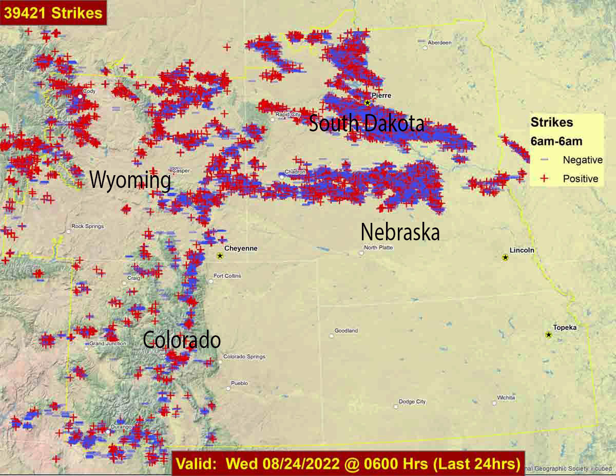
Lightning strikes during 24-hour period ending at 6 a.m. Aug. 24, 2022. Lightning strike data from Rocky Mountain Area Coordination Center.
During the 24-hour period ending at 6 a.m. Wednesday 39,421 lightning strikes were detected in parts of Wyoming, Colorado, South Dakota, and Nebraska. In many areas there was not a great deal of rain accompanying the lightning.
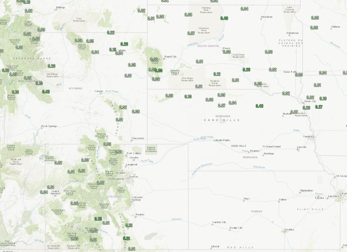
Precipitation during 24-hour period ending at noon Aug. 24, 2022.
The weather forecast for Cheyenne, Wyoming on Wednesday is for 84 degrees, 12 mph winds out of the southeast, 30 percent cloud cover, and 22 percent relative humidity.
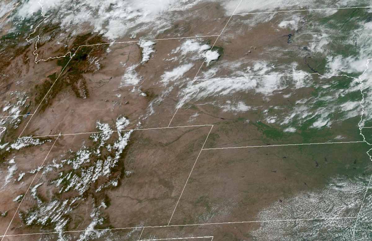
The satellite photo taken at 11:56 a.m. MDT on Wednesday shows partly cloudy skies over the general region.
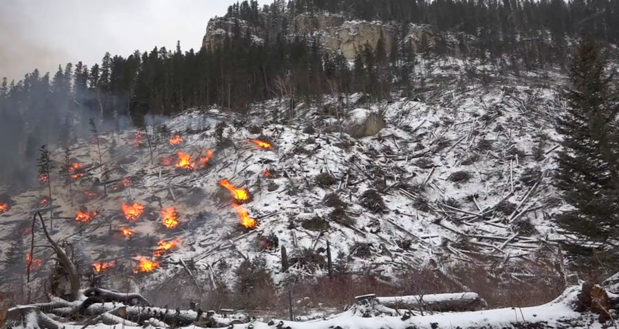
Spearfish Canyon pile burning January, 2022, Black Hills National Forest, South Dakota. Credit: USFS.
The Black Hills National Forest has produced a two-minute video about the process of cleaning up the dead vegetation resulting from two South Dakota tornadoes in recent years. We first posted a series of photos about the project last week, but in this video John Snyder, an acting District Fuels Assistant Fire Management Officer, gives us the details.
Map produced by a multi-mission aircraft Tuesday morning, Oct. 5; 964 acres.
Tuesday morning an aircraft mapped the Auburn Fire north of Rapid City and determined it had burned 964 acres.
Firefighters have conducted one or two firing operations on Tuesday to help secure the firelines. They are being assisted by a Type 1 helicopter which is dropping water.
Another fire broke out Tuesday in Southwest South Dakota 14 miles east of Hermosa and burned 650 acres on the Pine Ridge Reservation. Three single engine air tankers helped slow the spread.
10:34 a.m. MDT Oct. 5, 2021
The red dots on the map represent heat detected by satellites on the Auburn Fire as late as 2:54 a.m. MDT Oct. 5, 2021. Grass that burned and then cooled between overflights does not show up.
The Auburn Fire burned an estimated 500 to 750 acres north of Rapid City, South Dakota Monday. Overnight firefighters stopped the spread and completed a line around the blaze with the help of a tactical firing operation. Much of the fire burned through timber which will be smoking for days and will require extensive mop up.
It was reported at 1:49 p.m. Monday west of Auburn Drive between Haines and Deadwood Avenues north of Interstate 90. It started in Pennington County and spread north into Meade County.
Auburn Fire – photo by Rapid City FD, Oct. 4, 2021.
Evacuations ordered Monday were still in effect Tuesday morning. The areas affected theoretically could be seen on a map. However, our experience was that the map was not visible on a Chrome browser, but it did work on Firefox and Safari.
There have been no reports of any structures destroyed.
Resources on the fire Monday included one large air tanker, a large type 1 helicopter, two single engine air tankers, dozers, and federal, state, and local firefighters.
The Rapid City air tanker base at the airport was activated to reload the air tankers.
Auburn Fire, Oct. 4, 2021, looking north from Mt. Rushmore Road/US 16. Photo by Pennington County Sheriffs Office.
Near critical fire weather conditions are expected through Wednesday. The forecast calls for temperatures to be in the upper 80s or lower 90s with relative humidity falling into the 7 to 20 percent range. Winds are expected to be out of the south at 10-20 mph.
The aircraft used Monday were still available Tuesday morning if needed.
Dozer on the Auburn Fire, Oct. 4, 2021. Photo courtesy of Great Plains Fire Information.Auburn Fire – photo by Rapid City FD, Oct. 4, 2021.Auburn Fire – photo by Rapid City FD, Tuesday morning Oct. 5, 2021.
The Rapid City office of the National Weather Service acquired these satellites photos of the Schroeder Fire which has burned 2,195 acres just west of their city.
Here is how they described the photos in a Tweet Thursday evening:
“Sentinel-2 satellite views of Schroeder Fire on Mar. 29 (when it started) and today (Apr. 1). The red hot spots are not apparent today, and the reddish-brown area shows the extent of the fire. White = clouds in first image (black = shadows). Green = vegetation.”
The NWS office in Rapid City is on a hill about four miles due east of the Schroeder Fire. They probably had an excellent view of the fire, if the smoke permitted.
You can follow the Rapid City NWS on Twitter: @NWSRapidCity
The Schroeder Fire at Rapid City has burned 2,165 acres
Updated 8:01 a.m. MDT April 1, 2021
Schroeder Fire, March 31, 2021. Incident Management Team photo.
Mount Rushmore National Memorial opened for visitors at 5 a.m. Thursday, April 1. The 244 Fire within the Memorial has been more accurately mapped at 136 acres. Sixty firefighters from federal, state, and local government are working to secure containment lines, mop up hot spots, and remove hazardous snags from along roadways.
The Black Hills area is under a Red Flag Warning Thursday for winds gusting up to 35 mph and relative humidity in the low teens.
The Schroeder Fire grew by 30 acres Wednesday as firefighters conducted burnout operations to improve fire lines by removing unburned fuel between the lines and the main body of the fire. This slightly increased the fire’s size to 2,195 acres. Approximately 250 personnel are assigned to the fire.
Originally published at 9:50 a.m. MDT March 31, 2021
244 Fire at Mount Rushmore, March 30, 2021. NPS photo.
Firefighters have made progress on the three wildfires in the Black Hills of South Dakota.
Schroeder Fire
The largest is the Schroeder Fire just west of Rapid City. It was mapped from an aircraft at 4:30 p.m. on Tuesday and was found to have grown to 2,165 acres, an increase of about 260 acres. At that time it had not crossed Highway 44 or South Canyon Road and fire authorities are optimistic that they can keep it between the two roads.
The satellite overflights Tuesday night did not detect any very large heat sources on any of the three fires, but there are likely many locations on the blazes where heavy fuel is still burning or could even be slowly spreading through light fuels. Fire personnel will no doubt be mopping up for several more days, extinguishing logs and deep-seated heat.
Map of the Schroeder Fire. Data from 4:30 p.m. MDT March 30, 2021.
Most of the Schroeder Fire has burned in the footprint of the Westberry Trails Fire of 1988.
Map showing the locations of the Westberry Trails Fire of 1988 and the Schroeder Fire which was mapped March 30, 2021.
244 Fire
The 244 Fire is named after the highway that leads to Mount Rushmore National Memorial. Most of the fire’s 90 acres are within the boundary of the 1,200-acre Memorial, with the rest being in the Black Hills National Forest. The National Park Service said the Memorial is still closed today, March 31. There has been no announcement about when it will reopen.
Very little information has been released about the 244 Fire, but the last update at noon on Tuesday said the head of the fire was active, but generally it was “creeping”, moving very slowly.
Black Hills vulnerable to wildfires
Two hours after the Schroeder Fire was reported, the relative humidity increased from 16% to 50% and the temperature dropped 22 degrees, from 68 to 46 degrees. If that had not occurred it is likely that the three fires would have grown much larger, pushed by the very strong winds.
These wildfires occurring on the same day are an example of how vulnerable the Black Hills and the Mount Rushmore area are to fires, a fact often pointed out to advocates of exploding fireworks at the Memorial.
244 Fire at Mount Rushmore. Mapped by Colorado’s MultiMission Aircraft March 29, 2021. Supplied by the Incident Management Team.Map of the 244 Fire and the Keystone Fire, showing heat detected by satellites during the 24-hour period ending at 2:30 a.m. MDT, March 30, 2021. Wildfire Today and NASA.
Keystone Fire
The last update on the Keystone Fire, at 6:30 p.m. March 30, said personnel were “working to get a line around” the 9-acre blaze which is near Keystone. There were plans to have hand crews working on the fire on March 31.
Schroeder Fire, March 30, 2021. Photo by Incident Management Team.