The air tanker fleet at the Station fire

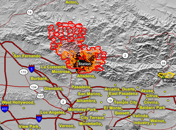
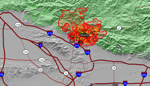
The LA Times has the scoop on the fleet of air tankers being used in southern California:

“Despite state and local budget cuts, crews have the air support they need to handle the Station fire, officials said.

The state budget that Gov. Arnold Schwarzenegger signed last month canceled the contract for California’s largest firefighting tool, a DC-10 jet, to save taxpayers about $7 million. It was replaced with a contract for two DC-10s on a pay-as-you-go basis, but at a higher hourly rate. But after several fires hit Northern California earlier this month, authorities reversed that decision and signed a 90-day contract for the plane, which costs taxpayers an average of $43,404 a day.

“The determination was made that it would cost more to have it on an as-needed basis than on an exclusive-use contract,” said Cal Fire aviation chief Bill Payne.

DC-10 drops on the Station fire near Acton, California, August 30, 2009. Photo: Irfan Khan

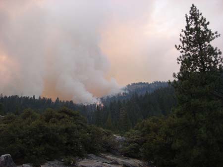
For many Southern California residents whose homes were threatened by the Station fire, the appearance of the DC-10 Saturday at the Station fire’s northern and southern flanks came as a welcome relief. The plane could be seen making drops of its bright red flame retardant on the hills of the Angeles National Forest, then making sharp banks as it turned around for additional passes.

Before the arrival of the DC-10, officials had been relying on helicopters and some smaller fixed-wing aircraft to drop water and fire retardant on the Station fire.

The U.S. Forest Service contracts a Martin Mars air tanker, sometimes called a “Super Scooper,” which carries a flame retardant foam concentrate. But that plane has had mechanical problems and has not been used to fight the Station fire. In addition, Los Angeles County has a contract for two additional air tankers, which it leases from the government of Quebec. But those planes — which are CL-415s — are not available until Tuesday, said Payne.

Initially, officials thought the county’s planes would not arrive in the area until Thursday. But at a press conference today, officials said the CL-415s would be available starting Monday and that a second DC-10 also had been requested.

The state will have to pay for that second DC-10 on a pay-as-you-go basis. According to its agreement with the contractor, Victorville-based 10 Tanker Air Carrier, Cal Fire guarantees to pay the company a minimum of $66,060 a day for a minimum of five days, Payne said. That amounts to about $330,000.”

==============

The above article from the LA Times refers to the Martin Mars as a “Super Scooper”, but as we were reminded by Kelly Andersson, that term is usually reserved for the Bombardier (formerly Canadair) CL-415 or CL-215. We also corrected the name of the CL-415 in the article, incorrectly referred to as “CL-14”.

Kelly documented some of the history of the SuperScoopers in a 1998 article that appeared in Wildland Firefighter magazine.

Thanks Kelly.

By the way, the difference between the CL-215 and the 415 is that the 415 has turboprop engines, and has an updated cockpit, aerodynamics enhancements and changes to the water-release system as well.

Yosemite's Big Meadow fire still spreading to the north

The Big Meadow fire, which was planned to be a 90-acre prescribed fire, has fire lines around about 80% of the perimeter but continues to spread on the north side where it has crossed Big Oak Flat Road and is within one to two miles of Tioga Road. Officially, as of 1:00 p.m. PT, August 30 it has burned 4,382 acres and is 50% contained.

This map of the Big Meadow fire was updated at 6 a.m. this morning.

It is interesting to see the completed dozer line, designated by the xxxxxx. It is unusual to use dozers in National Parks, but I am sure the National Park Service feels a great deal of pressure to put out this escaped prescribed fire and minimize the acres burned outside the park boundary.

Big Meadow fire, August 27. NPS photo

A 10 a.m. news release from the park had this information:

Yesterday, firefighters made good progress improving fire lines east of El Portal. The active portion of the fire is in the north and northwest flanks away from Foresta and El Portal. Today, the highest priority continues to be improving fire lines east of El Portal and structure protection in Foresta. Firefighters are aided by 11 water dropping helicopters and six air tankers. Control difficulties continue to be hot weather, low humidity, and steep terrain.

Time lapse video of Station fire

Eric Spiegelman used a Nikon D5000 still camera to take time lapse photos of the Station fire near Los Angeles, then with Quicktime stitched the images together into this very cool video. I’m not sure what day it was shot, but the video was uploaded on Saturday evening, August 29.

(THE VIDEO IS NO LONGER AVAILABLE)

And HERE is a link to a web cam in Mount Wilson that is threatened by the fire. The peak has a bazillion dollars worth of communications equipment that if put out of commission would cause major problems for TV and radio stations in the Los Angeles area as well as government agencies suppressing the fire.


Station fire, updated map, Aug. 30, 2:16 a.m.

The updated map of the Station fire near Los Angeles shows major spread of the fire on the north side. The map shows heat detected by satellites at 2:16 a.m. Sunday morning. The red areas are the most recently burned. The Morris fire to the east shows no recent heat.

GEOMAC
Map of Station fire produced by the incident management team. The correct date should be August 30.

As of early Sunday morning the Station fire had grown to 35,000 acres and had come to within 5 miles of the community of Acton. The southeast wind of Saturday changed to a down-canyon wind overnight, pushing it closer to some residential areas.

Extreme fire behavior caused the fire to spread in all directions on Saturday. Firefighters reported 80-foot flames as the 15-20 foot high brush burned.

The Station fire burns above Altadena, Californiaon August 28. Photo: Michal Czerwonka

On Sunday morning there may be an inversion which could slow the spread, but when it breaks up, extreme fire behavior could be seen again. The area is still under a red flag warning for high temperatures and low relative humidity.

Evacuations are in effect for areas in La Canada-Flintridge, Rockdale, Acton, Pasadena, La Crescenta, Altadena, Glendale, and Big Tujunga Canyon. For official information about evacuations go to the LA County Fire Department site.

Photo: Michal Czerwonka

Three to five homes were destroyed in Big Tujunga Canyon on Saturday where three civilians were flown out by helicopter with burn injuries.

About 1,804 personnel are assigned to the fire and it is 5% contained.

Updated map of Station fire, Aug. 29

UPDATE at 9:25 p.m. PT, Aug. 29

Fire personnel provided this map Saturday night. It is difficult to see much detail, but it might help those that live nearby.

(end of update)

=================================

This is a NEW updated map of the Station fire near Los Angeles is below. It shows heat detected by satellites at 2:17 p.m. PT today, August 29. The red areas depict heat detected within the last 12 hours. It shows a great deal of fire growth, especially on the west and north sides as it burns deeper into the Angeles National Forest and threatens homes in the front country.

The fire has burned into across Big Tujunga Road and west over Mt. Lukens. It threatens homes in La Canada -Flintridge, Altadena, and Glendale.

Southeast winds at 6-12 mph contributed to the spread toward the northwest on Saturday. The potential exists for Sunday’s fire behavior to be similar to that seen on Saturday.

Firefighters report that the fire has burned 20,102 acres and it is 5% contained.

Station fire map, 14:17 p.m., Aug. 29. Data from GEOMAC.

Information from the LA Times:

The Station fire was spreading rapidly to the east and west this afternoon, prompting evacuations in La Cañada Flintridge, Glendale, Altadena and Big Tujunga Canyon as temperatures reached triple digits.

Los Angeles County Fire Department dispatcher Melanie Flores told The Times that two people were being treated for burns at the Big Tujunga ranger station, though more details were not immediately available.

The Station fire has now burned more than 20,000 acres, according to fire officials.

The latest evacuation zone is in the remote upper reaches of Big Tujunga Canyon near the ranger station, according to the California Department of Forestry and Fire Protection. The city of Glendale also ordered evacuations north of Santa Carlotta Street between Pennsylvania and Lowell avenues. The city of Pasadena advised residents of the Florecita neighborhood in the far northwest of the city to evacuate their homes voluntarily.

Temperatures topping 100 degrees, single-digit humidity and the steep, rugged topography of the Angeles National Forest continue to make the fire a formidable foe despite low winds, fire officials said today.

Greek fires may change political balance of power

Hundreds of Greeks staged a silent protest in Athens on Friday to condemn the failure of the government to stop the devastating fires that burned into the suburbs of Athens recently. About a thousand protesters assembled in front of the Greek parliament to express their outrage to the scandal-plagued administration that “allowed” a similar fire storm in 2007. 

Approximately 65 homes were destroyed and 143 others were damaged in the fires that burned near Athens between Friday and Tuesday of last week.

The two main political parties are about evenly matched in Greece. If the dissatisfaction with the administration caused by the wildfires gains momentum, it could result in many of the current office-holders being replaced by candidates from the opposing party during the next election.