UPDATE @ 8:00 p.m., Sept. 8
The Rocky Mountain Area Coordination Center had the following update about the Fourmile fire at 7:20 p.m. today:
Four Mile Canyon Fire Update: (CO-BLX) , 5 miles west of downtown Boulder, CO. Single tree torching with creeping in Douglas-fir, Ponderosa pine and grass was observed today. Transition expected from Type 2 (Richardson) to Type 1 (Thomas) will occur at 1800 Tomorrow. Red flag predicted for tomorrow for high winds and low humidity. Currently at 6,365 acres, 10% contained.
=====================================
UPDATE @ 6:15 p.m., Sept. 8
The Boulder County Sheriff’s Office has provided a list of 140 structures that have been destroyed by the Fourmile Canyon wildfire and another 24 that have been damaged by the fire.
======================================
UPDATE @ 4:00 p.m., Sept. 8
My favorite quote so far about the Fourmile fire is from an article today at the Daily Camera:
The fire burned in on itself, shrinking its overall size to 6,168 acres.
We need to figure out how to harness that technology or phenomenon, whatever it is, but it might put firefighters out of a job.
By the way, some of the comments on that article are interesting.
Boulder County has posted a new map of the fire.
======================================
UPDATE @ 1:05 p.m., Sept. 8
Adam K. plotted the locations of the structures that have been reported by the Boulder Office of Emergency Management as having burned as of 9:42 p.m. on September 7. The information is preliminary and incomplete, and Wildfire Today assumes no responsibility for the accuracy of the data. Here is how the list of addresses with burned structures was described by the Boulder OEM:
9:42 p.m. – Sept. 7, 2010 – The Boulder County Sheriff’s Office is providing this information to residents who have been affected by the fire. The addresses listed below are of houses that the Sheriff’s Office has identified as destroyed by the Fourmile Canyon Fire. These addresses were determined from only 5-10% of the burned area, as that is the only area that could be safely surveyed today. Some parts of the burned area are more densely populated than others. In most cases, Sheriff’s deputies were able to identify addresses by the homes’ mailboxes, some of which are grouped with other mailboxes, so while we intend this to be an accurate list of addresses, we are working under difficult conditions in determining the actual address of each home.
We will continue to post more information as it becomes available following additional investigative work on Wednesday.
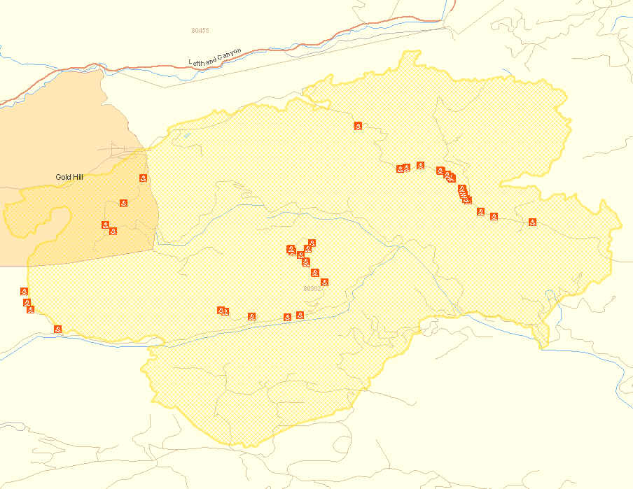
More detailed maps:
Thanks Adam.
There is a report that nine volunteer firefighters lost their homes in the fire.
.
============================================
UPDATE @ 9:20, Sept. 8
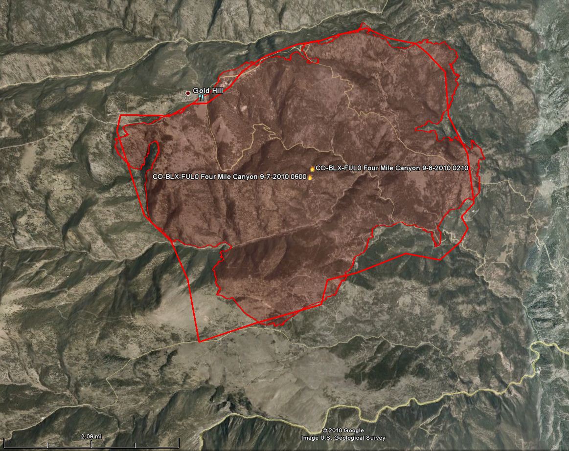
Kyle let us know about a recent map of the fire on a National Weather Service site. Thanks Kyle. I have mapped a lot of fires, and judging from the fact that this perimeter line is very jagged, rather than having a lot of connected straight lines, I’m thinking that it is very accurate. Here is a screen capture of the map:
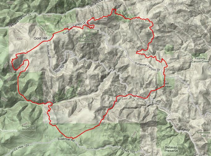
The map below shows the last two perimeters of the fire provided by the incident management team. The one with the sections of straight line was from Sept. 7, at 6:00 a.m. and the other, dated at 2:10 a.m. today was probably made from the infrared mapping flight. Click on the map to see a larger version.
The Denver Channel has dramatic photos of homes burning.
============================================
There is not a lot of new information available about the Fourmile fire near Boulder. A very recent update at the Inciweb site is calling it 7,100 acres. The official Incident Status Summary (ICS-209) from last night includes this:
Significant Events: 20 subdivisions west of Boulder have been evacuated and 3 major County roads closed. Fire Continues perimeter growth and associated structure loss. Transition from Type 3 to Type 2 (Richardson) occurred at 1800 today (9-7).
Observed Fire Behavior: Crowning, running, spotting, creeping in Douglas-fir, Ponderosa pine and grass.
Planned Actions: Structure protection and damage assessment. Continue line construction on remote sections of fire.
When an updated fire map is available, we will post it here. The latest maps are in our update from yesterday and at InciWeb.
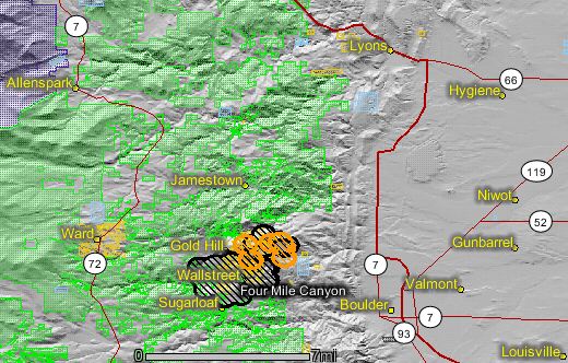
In the meantime, here is a map of the fire showing heat detected by satellites last night. The most recent fire activity (in brown) was on the northeast side.
The most current official report from yesterday on the number of structures burned was that they had surveyed 5-10% of the burned area and had documented 63 that had burned. When the fire conditions permit, they will go into other areas to record the damage.
The Gold Hill Townsite has some very good photos, some of them spectacular, of the fire. (UPDATE: so many people have gone to the site that it is down, saying “bandwidth exceeded”. Check back later.) It also has a link to some amazing video shot by a firefighter as houses burn; when you view it, click on “go full screen”.
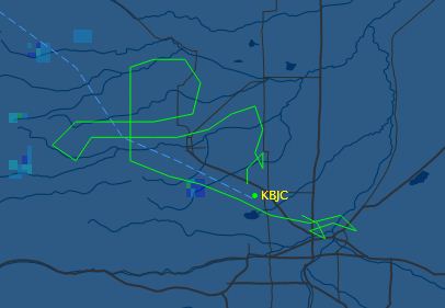
We are hoping to get an updated fire perimeter map and a more accurate size of the fire that should be available following the infrared mapping flight from last night. As we reported yesterday, The U.S. Forest Service infrared mapping aircraft, N149Z, flew from Boise to Rocky Mountain Metro Airport last night, flew over the Fourmile fire several times and landed at 8:08 p.m.
Then at 2:02 a.m. this morning N149Z took off again, flew over the fire three more times, and landed back at Metro at 2:24 a.m. Here is a map showing the latest flight. KBJC is Metro airport, and Denver is in the lower-right.
Here is a time-lapse video that was shot last night of the Fourmile fire near Boulder.

Great coverage on the fire. I am part of an out of state wildland crew on the east coast and we have been waiting for our call to go to the Fourmile Fire and your reports keep us well informed incase we get the call
Thank you
Thanks. And thanks for visiting Wildfire Today.
The nighttime time lapse video shows you how gorgeous a deadly creature can be. I especially like the little fireflies, probably the headlights of fire vehicles, that dart around the unburned hills in the foreground.
I like time-lapse videos, especially if they are taken at night and include a wildland fire.
Excellent, these maps are really useful, thanks. I added the link to my list of resources for the Boulder fire at http://allhazards.blogspot.com/2010/09/colorado-wild-fire-resources.html
Revise the Date. Great Map
Oops. Thanks.
The Boulder NWS site has a good perimeter map:
http://www.crh.noaa.gov/bou/?n=fourmilefire_briefing