(UPDATE at 10 a.m. Arizona time, May 25, 2014)
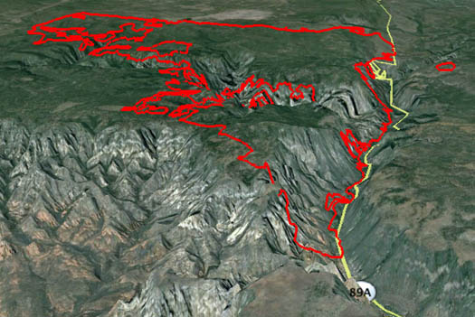
The Slide Fire north of Sedona, Arizona has grown to 13,423 acres as of the latest infrared mapping at 12:15 a.m. Sunday.
Smoke over the fire restricted the use of aircraft to drop water or fire retardant on Saturday, but firefighters continued using burnouts to remove the fuel out ahead of the fire in order to ultimately stop the spread and achieve control.
****
(UPDATE at 8:10 a.m. Arizona time, May 24, 2014)

The incident management team running the Slide Fire north of Sedona, Arizona is using very large burnout tactics in an attempt to corral the blaze that has grown to over 10,000 acres. Many of the additional acres are a result of the burning operations out ahead of the main fire.
Below is a report from the incident management team Friday night:
The fire burned with lower intensity today across most of the fire, allowing firefighters to make progress. However the fire was very active in the area of Howard Pocket NW of Oak Creek Canyon. Crews conducted successful burnout operations along the “switchbacks” down Highway 89A to the fish hatchery which, will continue tonight. Firefighters, protecting structures in evacuated areas, were able to allow the fire to slowly back downhill to the containment lines behind the structures. This action will provide more security for evacuated homes. Firefighters held fire lines on the SW flank of the fire adjacent to the Secret Mountain Wilderness. On the north and west side of the fire, crews were able to improve lines along FR 535 to the power line and southeast along FR 231, facilitating burnout operations when weather conditions permit.
A burn out operation will be initiated tonight and is part of the overall containment strategy on the NW section of the fire. The idea is to create an area northwest of the main fire that circles the deep canyons, including West Fork of Oak Creek, keeping firefighters out of very hazardous terrain. When burnout operations are completed, it will halt the main fire as it approaches, because of the lack of fuel. Although this strategy will increase the total fire acreage it also lessens impacts to natural resources and provides for the safety of firefighters. These actions are taking place because firefighter and public safety are our number one priority.
Firefighters plan to conduct burnout operations overnight while atmospheric conditions dampen fire intensity.
****
(UPDATE at 12:18 a.m. Arizona time, May 23, 2014)
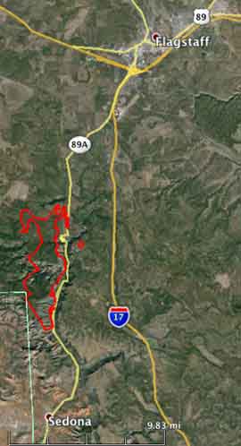
Firefighters are making progress on the Slide fire north of Sedona, Arizona, largely due to the use of burnout operations. They report that 7,500 acres have burned and they have constructed and held fireline on five percent of the perimeter.
Thursday night fire crews made good progress conducting burnout operations along the north and east flanks of the fire. Several small spot fires were contained south of FSR 535 through the evening hours. Additional burnout operations were conducted starting near the upper canyon ‘switchbacks’ on Highway 89A southward to the Fish Hatchery.
Today firefighters will continue working in the East Pocket area to the southwest using possible retardant and water drops in the rugged terrain. Prep work will also continue along FSR 231 and FSR 535 in preparation for aerial ignitions and ground burnout operations to the north and west flanks. Forming a ‘catcher’s mitt’ to the northwest, this suppression strategy will significantly increase acreage, but is essential to firefighter safety in extreme canyon terrain. Safety remains the number one priority in all wildfire operations. Fire managers anticipate lower intensity fire behavior within the ‘catcher’s mit’ containment lines. Crews will also work to hold hand and dozer line completed overnight near the Fish Hatchery. If conditions permit, crews may conduct burnouts near Slide Rock State Park to secure the southernmost containment lines.

****
(UPDATE at 9 p.m. Arizona time, May 22, 2014)
From the Incident Management Team, Thursday evening:
Crews continued to hold the fire west of Highway 89A and south of Fry Canyon. A small spot fire occurred across the northern line into an area that was previously thinned in 2006. Because this area was previously treated, the spot fire was unable to grow and crews quickly extinguished it. Hotshot crews also worked to create fire line across the Pumphouse Wash near the Hwy 89A ‘switchbacks’ to control the east flank and prevent further spread east. Winds increased to 18-22mph with gusts of 32, temperatures were in the 70s. As the day continued to warm, firefighters saw an increase in fire behavior, with the most active portion of the fire toward the northwest to Harding Point. Firefighters observed active fire in the East Pocket area, but previously dropped retardant helped firefighters minimize growth.
The Incident Management Team reports the fire has burned approximately 7,500 acres, and 5 percent of the fire perimeter has contained fireline.
Arizona Highways has some excellent annotated aerial photos of the fire.

****
(UPDATE at 8:58 a.m. May 22, 2014)
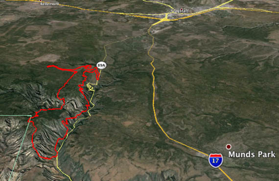
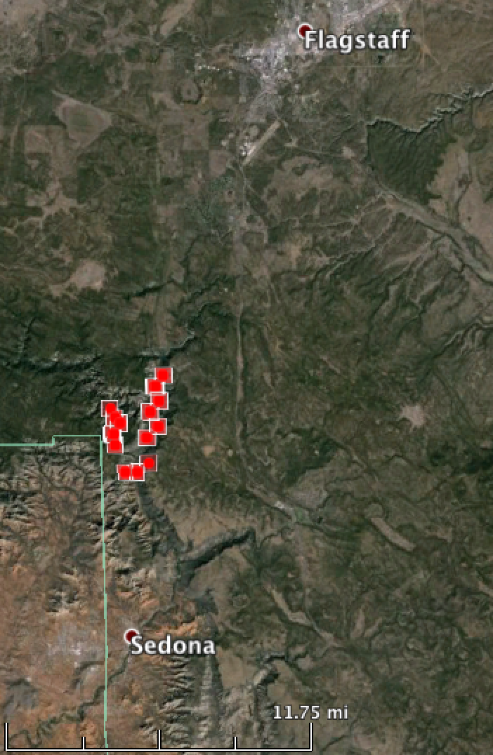
The map above shows in 3-D the perimeter of the Slide fire north of Sedona Arizona at 11 p.m. May 21. Below is a conventional overhead map view of the fire.
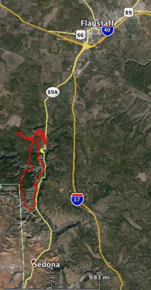
The estimated size of the fire is 4,830 acres; the incident management team says there is no containment.
Yesterday fire managers saw very active fire behavior including runs, spotting, and torching as the fire became established in the upper Sterling Canyon area. Crews quickly responded with burnout operations along FSR 535 west to HWY 89A to the north. Fire retardant was also used heavily in steep terrain along the west flank with good results. The fire transitioned to a Type 1 Incident Management Team bringing many additional resources to the fire.
Last night cooler temperatures and higher relative humidity moderated fire behavior. Crews completed burnout operations north of the fire.
Today firefighters are concentrating on holding the fire west of Highway 89A and south of Fry Canyon. Firing operations will likely continue in these areas as crews work to hold work completed yesterday. Additional work may include potential firing operations along the upper 89A ‘switchbacks’ to hold the northeast fire flank.
****
(UPDATE at 8:39 p.m. Arizona time, May 21, 2014)
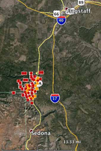
The map of the Slide Fire shows heat detected by a satellite at 3:28 p.m. Arizona time on Wednesday.

The map above shows the location of the fire perimeter as estimated by the Incident Management Team at 10 a.m. on Wednesday.
The Slide Fire has burned, officially, 4,500 acres and there is no containment. It is located in Oak Creek Canyon just north of Slide Rock State Park and burning northward, up the canyon into places such as West Fork and Harding Point.
Wednesday afternoon firefighters began burn out operations off FSR 535 to create a defensible space between the fire and Hwy 89 and FSR 535. All air resources have been shut down due to high winds. Firefighters are concentrating on keeping the fire west of Highway 89A, minimizing impacts to structures and utilizing terrain and fuel features to fight the fire.
Extreme fire behavior has been observed as the fire is well established in the upper end of Sterling Canyon. As the fire has reached Pumphouse Wash, Kachina Village and Forest Highlands residents were given a pre-evacuation notice. The fire is currently located approximately 3 to 4 miles from those subdivisions. The elevation at the fire ranges from 5,000 to 6,700 feet.
On Wednesday the fixed wing aircraft had to be shut down due to gusty winds. The Mormon Lake weather station east of the fire (elevation of 7,400 feet) recorded wind gusts of 27 to 37 mph between 9 a.m. and 5 p.m., a relative humidity of 10 percent, and a temperature of 63. The forecast for the fire area for Thursday calls for 5 to 15 mph winds gusting to 30 mph, and a relative humidity of 10 to 14 percent.
The video below was produced at 11 a.m. on Wednesday when the Incident Management Team was still saying the fire had only burned 500 acres.
****
(UPDATE at 7:25 a.m. Arizona time, May 21, 2014)
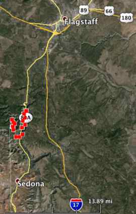
We have a map of the Slide fire six miles north of Sedona, Arizona that shows heat detected by a satellite at 2:50 a.m. local time today. Our very rough estimate is that the fire had burned about 1,800 acres at that time.
The Morman Lake weather station east of the fire recorded the wind at 8 mph out of the south-southwest at 7:03 a..m., with peak gusts to 22 mph. The temperature at that time was 51 degrees with a 23 percent humidity. The maximum wind gust over the previous 24 hours was 38 mph.
Morning view of #SlideFire just north of Sedona threatening 100 homes. Fire at 500 acres. @12News pic.twitter.com/xFEsp6Nc6M
— Chris Hrapsky (@chris12news) May 21, 2014
We will update this article as more information is available.
****
(Originally published at 10:20 p.m. Arizona time, May 20, 2014.)
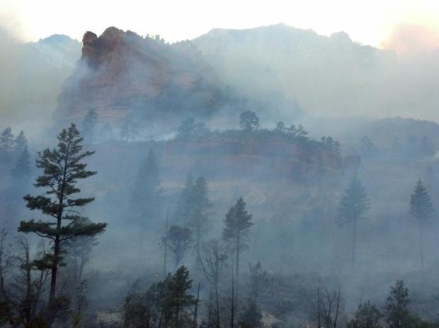
The Coconino National Forest is mobilizing a heavy response to the Slide Fire that started Tuesday at 4 p.m. in Arizona north of Slide Rock State Park, six miles north of Sedona. The fire started in Oak Creek Canyon.
At 9 p.m. Arizona time the Southwest Area Coordination Center reported that the fire was about 500 acres, and already a Type 1 Incident Management Team (IMT) and 15 additional Type 1 crews, over and above the initial dispatch, had been ordered. Sciacca’s IMT will inbrief at 3 p.m. on Wednesday.
Evacuations are taking place north of the State Park where about 100 structures are threatened. Highway 89A from Sedona to Fort Tuthill is closed.
Fire managers reported that there was a 39 mph southeast wind pushing the fire while the relative humidity was 9 percent.

Thank you Bill! This is the most information I have gotten the entire day! My Daughter lives SW of the I-17/I-40 junction. I’m sure she will be fine, but a mother worries…. It was good to see where the fire is in comparison.
The last time I was down 89A (about a year ago). Forestry crews have done a nice job of cleaning up the forests along 89A. Under brush was gone, trees thinned, remaining trees were limbed. I would imagine that prework should pay off and 89A will be pretty defendable as a boundary.
hoss
We have a beautiful 57 year old family cabin in Pine Flats just below Pumphouse wash, north of Junipine and Garland’s. We wish we could get information on whether Pine Flat homes have been lost to the fire. While we are concerned about our place, we are more concerned about the safety of the fire fighting crew in the canyon. I was glad to hear they called back the crews this afternoon due to high winds.
I went to grad school at NAU and have a sister and brother-in-law who live in Mountainaire, a bit north and on the other side of I-17 from the fire. Glad to see this is being taken seriously – a fire in Oak Creek Canyon during the dry season with strong southwest winds has been on the worst-case scenario list for the Flagstaff area for a long time, and now it’s happening.
Barbara,
We’re about six miles south of Mountainaire in Munds Park and, at this time, the fire seems to be heading in a northwesterly direction. I think, unless, the wind direction does a 180, Mountainaire and MP will be OK. Passed Kachina Village about an hour ago and the fire/smoke was directly behind Kachina. There are preliminary plans for evacuation in place and the area was filled with fire/forest vehicles. Fire has not jumped 89A – so far – but the wind seems to be increasing. IF it reaches Kachina and IF it manages to cross I-17 and IF the wind changes direction, then Mountainaire could be in harms way and Munds Park could follow. But… that’s a lot of IF’s.
We’ll think very good thoughts…..
We are planning a camping trip to Willard Springs this Friday. Do you think it will be open and safe?