Rocky Fire, east of Clearlake, California

(Our previous article about the Rocky Fire near Clearlake, California had been updated many times and was becoming large, so we are starting fresh with this article beginning August 2. It will continue to be updated.)

(An updated report on the Rocky Fire was published the morning of August 5, 2015)

****

(UPDATE at 6 a.m. PT, August 4, 2015)
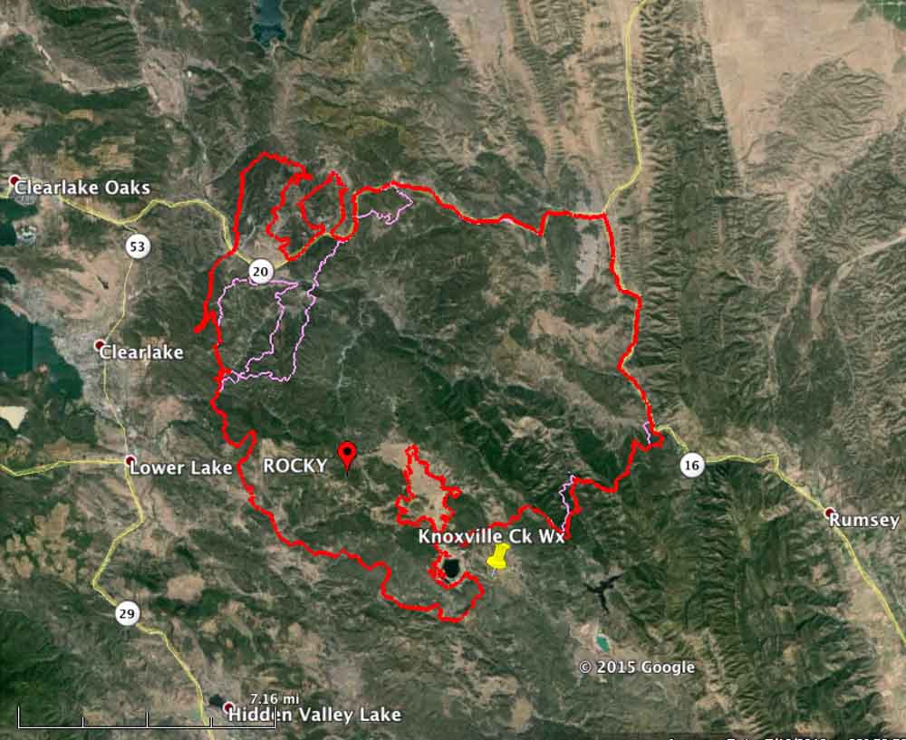
Map Rocky Fire
Map of the Rocky Fire at 2:30 a.m. PT, August 4, 2015 (in red). The perimeter from the day before is in pink. (click to enlarge)

Yesterday we wrote that firefighters had been able to keep the Rocky Fire from crossing Highways 20 and 16. That changed Monday afternoon when airborne burning embers northeast of Clearlake, California started multiple spot fires across Highway 20. Some of the new fires merged (see the map above), leaving two large fingers of fire, one of them three miles long, heading north coming within three miles of Indian Valley Reservoir.

The good news is that the fire grew very little in other areas. It is still primarily west of Highway 16 and the perimeter on the south and southwest sides has expanded only a small amount over the last 24 hours.

Tuesday morning at 2:30 a mapping flight determined that the fire has blackened 68,810 acres.

CAL FIRE is still reporting 24 residences and 26 outbuildings destroyed by the Rocky Fire. Evacuations have affected at least 13,118 residents in 5,530 residences.

On Monday the Air National Guard’s Modular Airborne FireFighting System (MAFFS) C-130 air tankers recently activated flew 7 sorties dropping 20,476 gallons of fire retardant on the Rocky Fire.

The spotting across Highway 20 occurred in the afternoon during a period when winds out of the south were gusting up to 18 mph and the relative humidity reached a low of 16 percent. The forecast for Tuesday is for 83 degrees, 27 percent RH, winds out of the east then southeast at 2 to 7 mph, and mostly cloudy skies in the afternoon until 5 p.m. These weather conditions should moderate the fire activity compared to what firefighters saw on Monday.

****

(UPDATED at 6 a.m. PT, August 3, 2015)
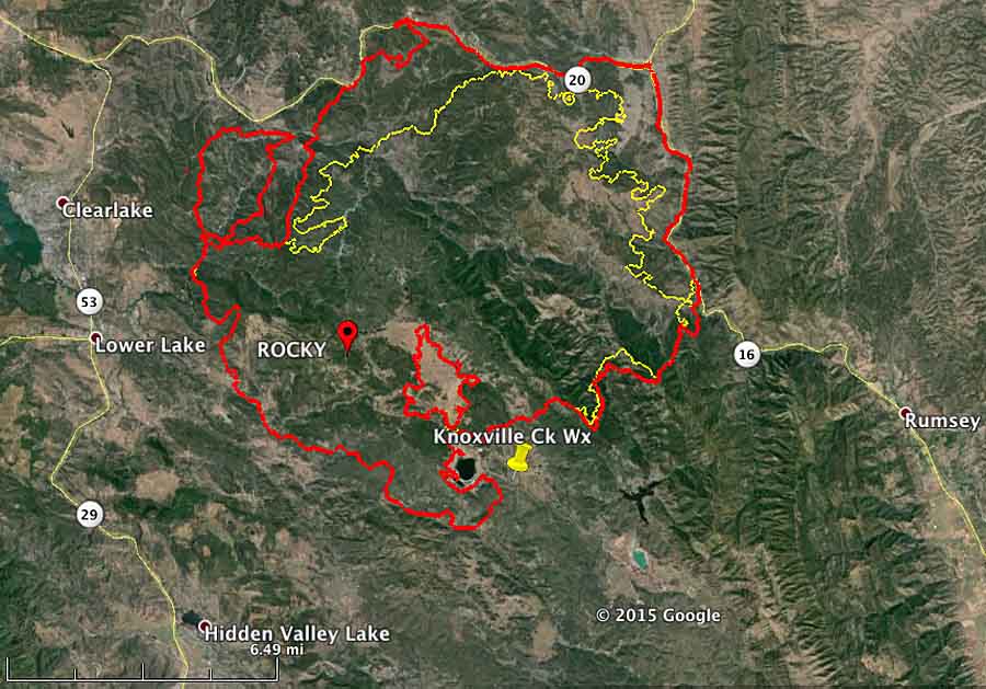
map of Rocky Fire 630 pm PT August 2, 2015
Map showing in red the perimeter of the Rocky Fire at 6:30 p.m. PT, August 2, 2015. The perimeter from 16 hours before is shown in yellow. (Click to enlarge)

Firefighters continue to battle the Rocky Fire east of Clearlake and Lower Lake, California, which has grown to 60,000 acres. They are having some success on the north and east sides where the spread of the fire has been stopped in some places, for now, along Highways 20 and 16. But there is still a great deal of uncontrolled fire edge that must be dealt with.

The two highways, 20 and 16, are closed. CAL FIRE reports that evacuations are impacting over 12,000 residents, but that number has not been updated in a while. The number of residences destroyed, according to their information, remains at 24.

There was good relative humidity recovery overnight when it increased to 84 percent by 5 a.m., but it will slowly decrease on Monday to a low of  24 percent by 3 p.m. The maximum temperature will be 85 and in the afternoon the 2 mph southeast wind will increase to 10 mph out of the southwest around 5 p.m. These conditions on Monday morning will give firefighters a chance to make some headway on containing the fire, at least until mid-afternoon.

**** (UPDATED at 8:39 p.m. PT, August 2, 2015) CAL FIRE is calling the Rocky Fire east of Clearlake, California 54,000 acres and 5 percent contained as of Sunday evening.

****

(Originally published at 9:35 a.m. PT, August 2, 2015)

The Rocky Fire east of Clearlake, California more than doubled in size on Saturday. CAL FIRE reported that it had burned 22,500 acres on Saturday morning, and a mapping flight at 2 a.m. Sunday determined that it had exploded, again, and has now blackened 47,000 acres. Two highways in the area are closed, Highways 20 and 16. (See the map below.)

The weather conditions on Saturday were fairly conducive to significant fire spread — 95 degrees, 21 percent relative humidity, and southwest winds at 8 mph gusting up to 17. The forecast for Sunday is somewhat more moderate — 90 degrees, 32 percent RH, and winds switching from the west to south at 2 mph increasing to 9 mph in the afternoon.

Combined with low vegetation (fuel) moisture, another 25,000 acres went up in smoke Saturday as the fire spread to the north and east coming close to, and in some areas reaching, Highway 20 on the north and 16 on the east. CAL FIRE reported at 7:45 Sunday morning that the fire had not crossed the roads. Firefighters were burning out or backfiring ahead of the fire in some places along the highways.
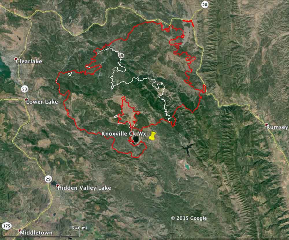
Map Rocky Fire
Map of the Rocky Fire at 2 a.m. PT August 2, 2015 (the red line). The white line was the perimeter about 24 hours before. (click to enlarge)

The Rocky Fire has destroyed 24 residences and 26 outbuildings, according to CAL FIRE. Evacuations have impacted over 12,190 citizens living in 5,201 residences.
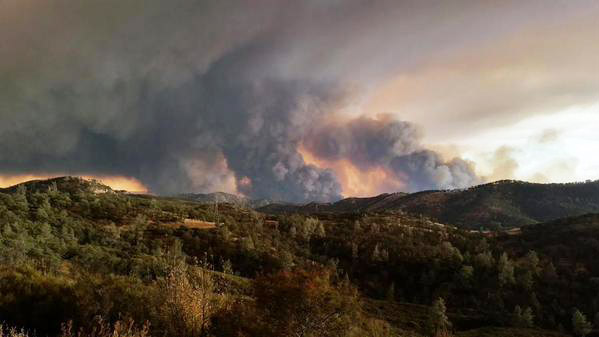
Rocky Fire August 1, 2015
Rocky Fire, August 1, 2015. CAL FIRE photo.

Outlook for wildfire potential, August through November, 2015

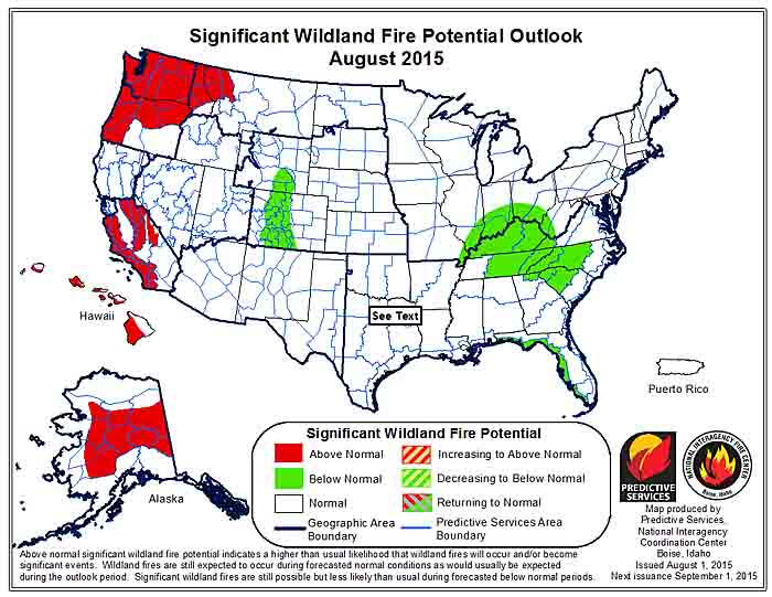
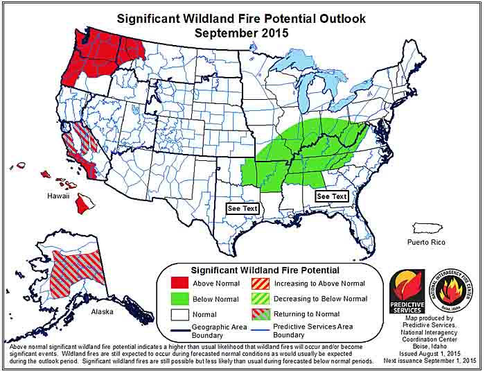
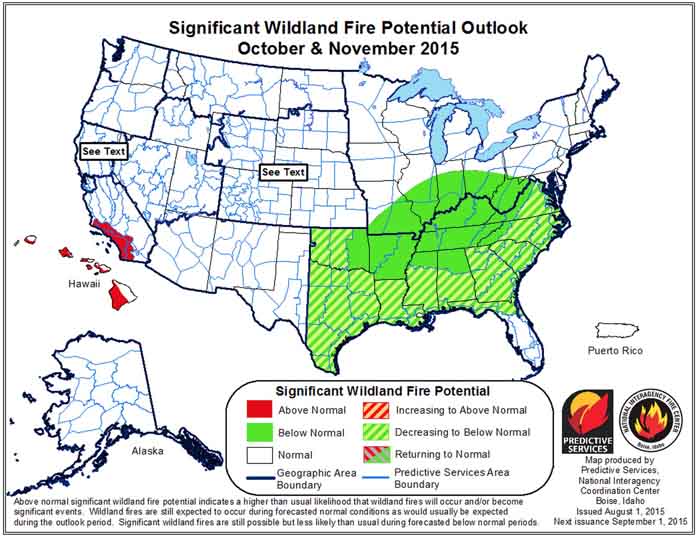
The Predictive Services section at the National Interagency Fire Center has issued their Wildland Fire Potential Outlook for August through November, 2015. The data represents the cumulative forecasts of the ten Geographic Area Predictive Services Units and the National Predictive Services Unit.

If their forecasts are accurate, portions of Idaho, Washington, Oregon, California, Alaska, and Montana will have above normal wildfire activity through September.

It is interesting that northern California, where many fires are growing at very, very rapid rates, has “normal” wildfire potential according to the analysis for August, perhaps because of this statement in the document about northern California:

The strengthening El Niño pattern will cause occasional monsoon surges, mainly in August.

Here are the highlights from their outlook.

****

August

wildfire potential August

  • Drier than normal fuels and little forecasted relief have led to above normal significant fire potential for most of the Northwest and western
    portions of the Northern Rockies.
  • Long term drought will keep significant fire potential above normal in Southern California.
  • Alaska will see continued periodic acreage growth from established fires which will lead to overall above normal significant fire potential.
  • Elsewhere mostly normal activity should be expected; which includes frequent significantfires and plentiful initial attack for August.

September

wildfire potential September

  • Central California and Alaska will see significant fire potential return to normal; however dry conditions are expected to persist in the Northwest, western Northern Rockies and far Southern California. 
  • Elsewhere primarily normal activity should be prevalent. For September, this means a rapid decline in both numbers of fires and acres burned for most Areas.

October-November

wildfire potential October November

  • Far Southern California will remain above normal for October and November; while most of the rest of the U.S. will be normal in many areas indicating little or no fire activity.
  • Below normal significant fire potential across most of the eastern U.S. for this period thanks to frequent moisture inputs represents a reduced fall and winter fire season for U.S. overall.

****

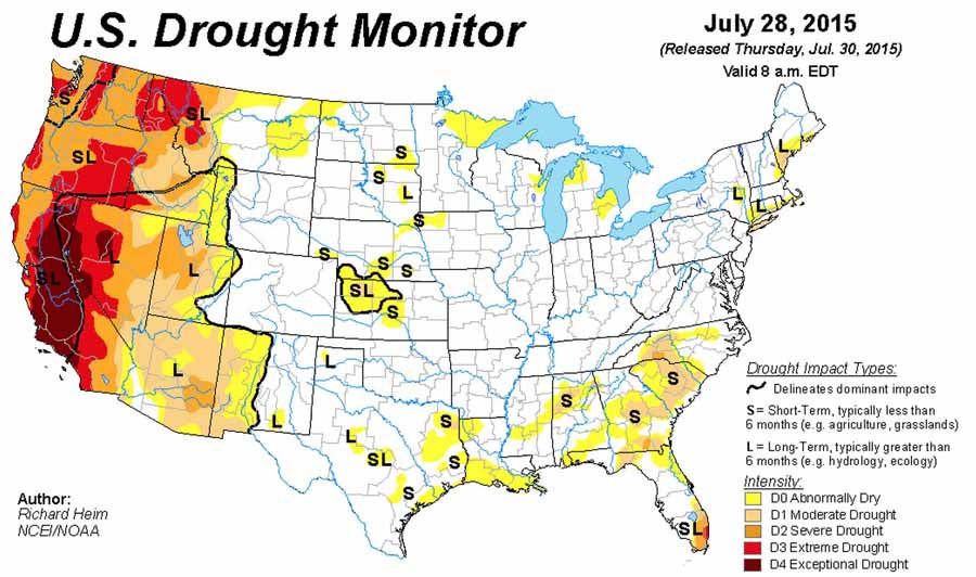
As a bonus, here is the Drought Monitor from July 28, 2015:

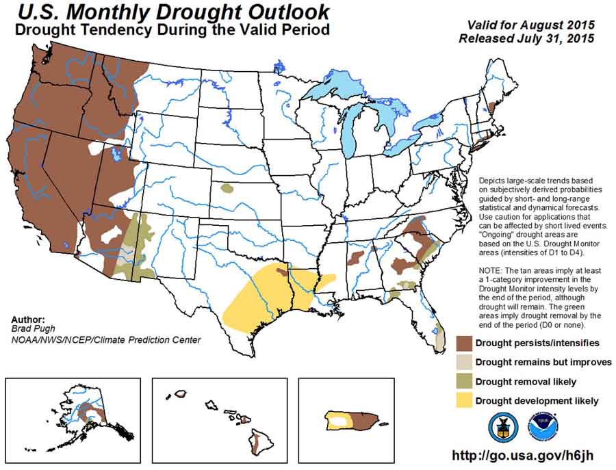
Drought Monitor July 28, 2015And, the U.S. Drought Outlook for August:

US Drought Outlook, August, 2015


New lightning fires in Shasta-Trinity NF burn 19,000 acres

(UPDATE at 9 a.m. PT, July 2, 2015)

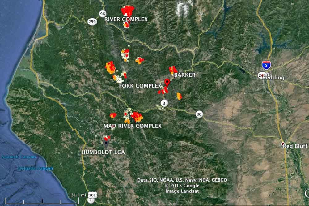
Map showing heat detected by a satellite on fires west of Redding, CA, at 2:44 a.m. August 2, 2015.

The management of the new lightning-caused wildfires detected in the last 48 hours between Redding and Eureka, California has been organized into at least three “complexes” of fires. Above is a recent map showing heat detected in the area by a satellite at 2:44 a.m., August 2, 2015.

****

(Originally published at 9:31 am PT, August 1, 2015)

Map of Shasta-T lightning fires
Map of Shasta-Trinity NF lightning fires at 8 p.m. PT July 31, 2015. (click to enlarge)

An infrared mapping flight over the Shasta-Trinity National Forest Friday night west of Redding, California detected numerous fires that together have burned 19,000 acres over the last 48 hours. The Shasta-Trinity clearly has a massive wildfire situation on their hands. These lightning-caused fires have grown significantly in the last 36 hours.

The area is under a Red Flag Warning for “abundant lighting” Saturday afternoon. Wetting rain is not expected to accompany the lighting.

More information about these fires is HERE.

Dry lightning and unstable atmosphere results in Red Flag Warnings

wildfire ed Flag Warnings August 1, 2015

The National Weather Service has issued Red Flag Warnings or Fire Weather Watches for areas in Washington, Oregon, Idaho, California, and Montana. Firefighters in northern California can expect abundant lightning Saturday afternoon, accompanied by little or no rain. In the other Red Flag areas dry and breezy conditions are in the forecast along with an unstable atmosphere and a high Haines Index which could contribute to rapid spread of existing or new fires.

The map was current as of 9 a.m. MDT on Saturday. Red Flag Warnings can change throughout the day as the National Weather Service offices around the country update and revise their forecasts and maps. For the most current data visit this NWS site or this NWS site.

Fire prevention at the Sturgis Motorcycle Rally

Don't Burn the Rally

In case you are not familiar with it, the Sturgis Motorcycle Rally is a big deal. Every year hundreds of thousands of motorcycle enthusiasts descend on Sturgis, South Dakota and the greater Black Hills area in southwest South Dakota and Wyoming. This year an even larger crowd, up to 1.2 million people, is expected since it is the 75th anniversary of the event which will be held August 3 through 9. Every motel within a hundred miles will be booked up, and at rates much higher than you’d pay at other times.

The wildland fire agencies are used to the routine and they usually make special preparations and have representatives designated to be the points of contact with the Rally Operations Center set up by the state Office of Emergency Management.

By Monday, August 3 there will be two single engine air tankers (SEATs) in the area, one each at Hot Springs, SD and at Chadron, NE. Two helicopters, a Type1 and a Type 3 are based at Custer, SD this year, but they have not spent much time there yet since they have been assigned to fires out of the area. The Type 3 will be available locally for the duration of the rally but the Type 1 is on an assignment elsewhere. The Black Hills National Forest has brought in six fire engines from other areas to beef up the local fire suppression capability. Currently there are no air tankers positioned at the Rapid City Air Tanker Base; however, the facility is open and staffed.

A few years ago the local agencies started the “Don’t Burn the Rally” program, in an effort to educate bikers from Ohio and Newfoundland about how not to burn the place down. Thankfully this year due to abundant rain in the spring and early summer the herbaceous vegetation is greener than usual, so it will be a little more difficult to get a large fire going.

I noticed the law enforcement officer on the Harley Davidson motorcycle in the poster above, and that there are no markings visible to identify the agency. I don’t know if they are still doing it, but Harley used to provide several bikes like that to the local National Parks, and possibly other agencies in the Black Hills, so that their law enforcement officers could use them during the rally. Some of the guys who had their own personal bikes loved being able to cruise around on a motorcycle while getting paid for it.

And below, you’ll see that even the weather forecasters in Rapid City are getting into the Rally spirit.

Rally weather forecast