Above: Map showing heat detected on the La Tuna Fire by a satellite. The red dots, the most recent, were detected at 2:42 a.m. PDT September 3, 2017.
(Originally published at 7:25 a.m. PDT September 3, 2017)
The Mayor of Los Angeles declared a local emergency as the La Tuna Fire forced hundreds to evacuate in Glendale and Los Angeles. Believed to be one of the largest in Los Angeles history, it had burned approximately 5,500 acres as of Saturday evening. Approximately three homes in Tujunga were destroyed.
Numerous air tankers and helicopters were dropping water and retardant to assist the firefighters on the ground.
Firefighters described extreme fire as the blaze spread rapidly spotting out ahead of the flames.
It is being managed in a unified Command with Burbank, Glendale and Los Angeles City.
A Federal Fire Management Assistance Grant was approved Saturday to help cover the suppression expenses.
He was returning from an assignment on the Sierra National Forest in California.
A firefighter was killed August 31, 2017 in a vehicle accident in California. Gary Helming, a Battalion Chief with the Los Padres National Forest in southern California, was returning from a wildfire on the Sierra National Forest.
According to the U.S. Fire Administration a Ford F-350 traveling in the opposite direction suffered a tire failure, crossed the middle of the road, and struck Chief Helming’s vehicle head-on.
The accident occurred on Highway 41 just south of state Route 33 in Kings County, California.
Our sincere condolences go out to Chief Helming’s family, friends, and coworkers.
Thanks and a tip of the hat go out to Allen and LM. Typos or errors, report them HERE.
Satellite photo from September 1, 2017 showing smoke from wildfires. The red dots represent heat detected by the satellite. Click to enlarge.Distribution of smoke from wildfires, September 1, 2017.
The prediction for October shows enhanced fire potential for the Northern Rockies and much of western California.
On September 1 the Predictive Services section at the National Interagency Fire Center issued their Wildland Fire Potential Outlook for September through December. The data represents the cumulative forecasts of the ten Geographic Area Predictive Services Units and the National Predictive Services Unit.
Below are:
the highlights of the NIFC report;
NIFC’s graphical outlooks for September through November;
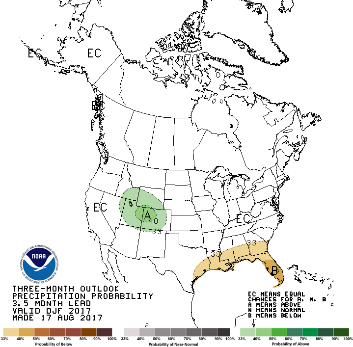
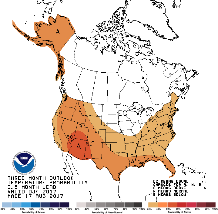
NOAA’s long range temperature and precipitation forecasts; and
Drought Monitor
****
“The Western fire season is reaching its peak for 2017 as it enters September. While an active southwestern monsoon has curtailed activity in the Southwest and across portions of the central Rockies, above normal significant fire activity continues to be observed across portions of the Pacific Northwest, Northern Rockies, northern Great Basin and northern California. Fuel moisture levels and fire danger indices in these areas are at near-record to record levels for severity. While the frequency and density of lightning occurrence has begun its seasonal decline, occasional lightning bursts are still being observed. Most of the new lightning-caused fire starts are being effectively handled with initial attack, but a few are still developing into larger incidents that require additional resources. Drier and warmer than average conditions across the central Great Basin and Southern California are allowing for the fine fuels to become more receptive to fire activity. A slight upturn in initial attack activity is being observed in both areas. Cool and wet conditions have arrived in Alaska. Its season has effectively ended.
Precipitation received was generally well below average across the Pacific Northwest, Northern Rockies, Great Basin and California in August as most areas received less than 25 percent of normal rainfall. Once exception to this was the Sierra Mountains in California where several episodes of wet convection produced rainfall amounts that were above average. Across the central Rockies and the Southwest, precipitation amounts were near average. Temperature extremes were less frequent in August than in July. For the month, average temperatures were only a few degrees above average.
Fire season will peak by mid-September as the fuels remain much drier than average and as existing precipitation trends continue. By mid-September decreasing solar radiation received and longer nights will allow for fuel moistures to begin recovering. Should a season-slowing weather event not occur, this will be sufficient to allow for the fire activity across the northwestern states to begin to decrease significantly late in the month. Significant large fire activity will remain possible in foehn wind-prone areas like the Rocky Mountain Front and across Southern California through November and will be event-driven should they occur.”
Above: The image shows heat detected by a satellite August 31 and September 1, 2017. The red dots are the most recent, early Friday morning.
The Diamond Creek Fire in the Pasayten Wilderness in the Okanogan/Wenatchee National Forest has crossed the Washington/British Columbia border and spread three miles into Canada. The Incident Management Team reports the total size of the fire is over 52,000 acres.
The satellite photo shows smoke from vegetation fires in the northwestern United States on August 31, 2017. The red dots represent heat detected by a satellite at 4:18 a.m. MDT September 1, 2017.