Important bridge that burned in Parker 2 fire replaced in a matter of days

Above: The Middle Fork Parker Creek bridge after the Parker 2 Fire moved through the area. (USDA photo by Chris Bielecki)

(Originally published at 1:50 p.m. MDT September 21, 2017)

(From the U.S. Forest Service)

As a wildfire rages across a forest, fire engines and heavy equipment travel swiftly along forest roads to get to the fire line. They arrive at the main bridge they need to cross, only to find it has burned and is impassible. This is not part of a storyline in a movie, it was reality for firefighters assigned to the Parker 2 Fire 10 miles east of Alturas, California on the Modoc National Forest (MNF) in August 2017.
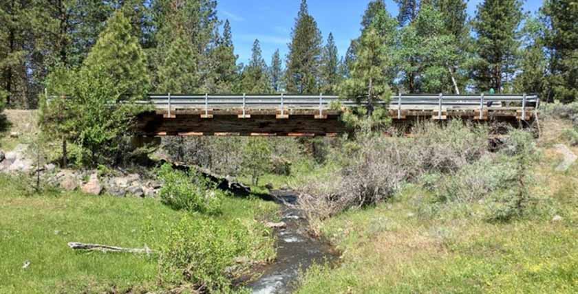
Parker 2 Fire bridge burned replace
File photo of the Middle Fork Parker Creek bridge earlier this year, before the fire. (USDA photo by Chris Bielecki)

When firefighters discovered the burned bridge in the Warner Mountains, they reported it to the Incident Management Team (IMT). Heather McRae, working as the Operations Section Chief Trainee on the IMT, remembered that there was an unused bridge being stored at the Ashe Creek Guard Station on the nearby Shasta-Trinity National Forest (SHF). When she isn’t working on fires, Heather works as the Prescribed Fire and Fuels Specialist on the SHF. Heather quickly relayed to the MDF about the possible replacement bridge.

Upon hearing about the unused bridge, MDF Roads Engineer, Alvin Sarmiento, coordinated with SHF Engineer, Virginia Jones, to investigate if the bridge would fit the span needed. Shortly thereafter, MNF was sending their construction and maintenance crew over to load the bridge and transport it to the Warner Mountains.

Parker 2 Fire bridge burned replace
A dozer prepares a foundation for the replacement bridge. (USDA photo by Chris Bielecki)

Understanding the urgent need for the bridge to be in place to help firefighters battle the Parker 2 Fire, the IMT prioritized the resources needed to move it into place. From the time construction actually began, to the time the bridge was crossed by the first firefighters, only five days had passed.

“This was an incredible team effort. We tapped into the power of the IMT ordering and buying team, supply specialists and ground support for picking up and delivering parts, the operations section for providing invaluable contract equipment and operators, and our local road crew,” said Chris Bielecki, Forest Engineer on the MDF. “And it still amazes me that the bridge was available in the first place, and that it was the right size. This experience was definitely a career highlight for me.”
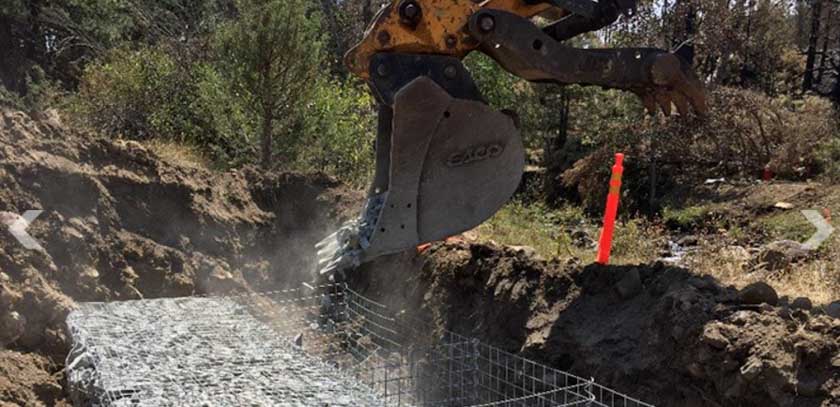
Parker 2 Fire bridge burned replace
Placing mechanically stabilized earth “baskets” and filling with crushed rock to form an abutment for the bridge. (USDA photo by Chris Bielecki)

While sharing resources among national forests isn’t something new to the Forest Service, the sharing and placement of physical structures like this bridge in the middle of an emergency is unique.

“When it comes to fighting fire or responding to other emergencies, if we can help another forest in their time of need, we will do it every time,” said Dave Myers, Forest Supervisor for the SHF.
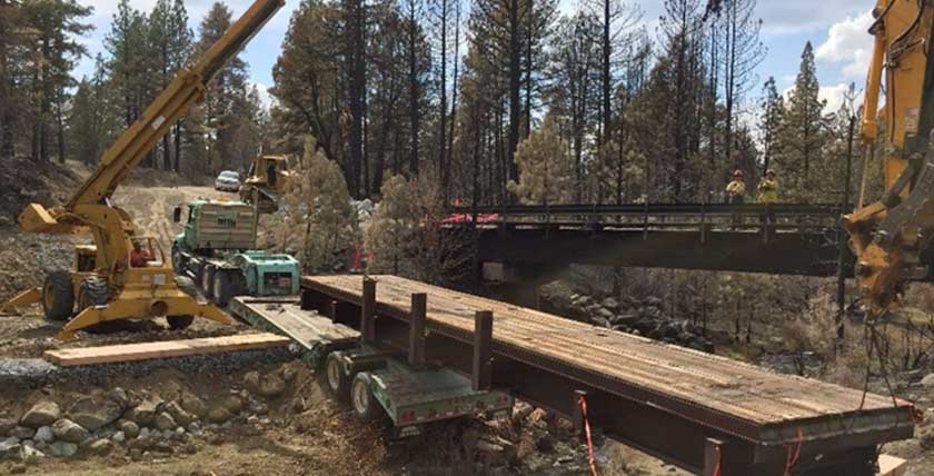
Parker 2 Fire bridge burned replace
The new bridge is put into place allowing firefighters access to the ongoing wildfire. (USDA photo by Chris Bielecki)
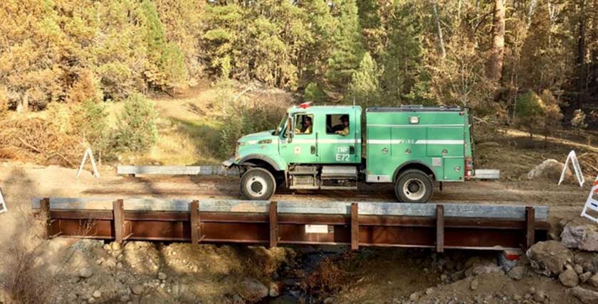
Parker 2 Fire bridge burned replace
The first firefighters to cross the newly placed bridge. (USDA photo by Chris Bielecki)

The Parker 2 Fire was contained at 7,697 acres.

Red Flag Warnings, September 21, 2017

The National Weather Service has issued Red Flag Warnings or Fire Weather Watches in a rather unusual pattern for areas in Wyoming, Colorado, Nebraska, and Kansas.

The maps were current as of 10:30 a.m. MDT on Thursday. Red Flag Warnings can change throughout the day as the National Weather Service offices around the country update and revise their forecasts.

Estimated precipitation
Estimated precipitation during the 48-hour period ending at 10:30 a.m. MDT September 21, 2017.

Report released for dozer operator who went missing

He deployed a fire shelter on the Pleasant Fire in California.

Above: photo from the CAL FIRE report.

The California Department of Forestry and Fire Protection (CAL FIRE) has released a “Green Sheet” preliminary report on an incident within an incident that occurred on the Pleasant Fire north of Nevada City, California August 30, 2017.

About half an hour after beginning work constructing fireline downhill, increasing fire activity forced a contractor-owned dozer to disengage. The operator walked the machine through unburned vegetation to a small cleared area near a greenhouse but after arriving, a burst hydraulic line leaked fluid which ignited, producing smoke and flames in the cab. He attempted to extinguish this new fire with an extinguisher, but failed, then exited the dozer and deployed a fire shelter as the main fire approached.

For about an hour no one on the fire knew where the dozer and operator were, in spite of numerous attempts on the radio to contact him and aerial searches by Air Attack and a helicopter. After an hour the operator used his hand-held radio to announce that the dozer sustained a hydraulic failure and he deployed a shelter, but he was unable to describe his location. Eight minutes later a helicopter spotted him and led ground personnel to the scene.

The operator complained of coughing, dizziness, and weakness. After being assessed by medical personnel, he walked downhill to an ALS ambulance for transport to a local hospital where he was treated and released.

Thanks and a tip of the hat go out to Tom.
Typos or errors, report them HERE.

Extreme mopup

Soldiers training firefighting
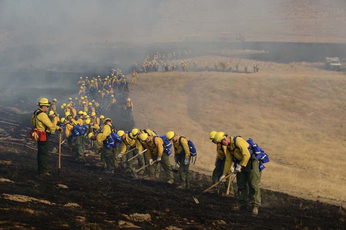
Oregon Army National Guard Soldiers during a firefighting training exercise at the Oregon Department of Public Safety Standards and Training in Salem, Oregon, August 28, 2017.

The U.S. Forest Service distributed this photo on Twitter September 17 that shows at least 90 Oregon Army National Guard Soldiers during a firefighting training exercise at the Oregon Department of Public Safety Standards and Training in Salem, Oregon, August 28, 2017.

Nearly 125 Citizen-Soldiers from the 41st Infantry Brigade Combat Team volunteered to join the second iteration of personnel, also known as NG-2, activated by Governor Kate Brown to assist with wildfires across the state of Oregon. The Oregon National Guard is currently assigned to three  fires in central and southern Oregon; the Whitewater, High Cascades Complex, and Chetco Bar fires. (Photo by Sgt. 1st Class April Davis, Oregon Military Department Public Affairs)

In addition to the National Guard, 200 members of the active duty military were activated from Joint Base Lewis-McChord in Washington earlier this month. Initially they were assigned to the Umpqua North Complex of fires 50 miles east of Roseburg, Oregon.

Rain and snow affect some fires in the Northwest — but not all

Wildfires are still active in California, Oregon, Washington, and northwest Montana. Red Flag Warning for northern Nevada.

Above: Indigo Fire in southwest Oregon, September 17, 2017. It is being managed by the East Zone of the Chetco Bar Fire. Inciweb.

(Originally published at 1 a.m. MDT September 18, 2017)

The precipitation that hit areas in the northern Rockies last week has slowed or in some cases temporarily halted, perhaps, the spread of some of the wildfires, many of which had been burning for more than a month. Higher elevations in portions of western Montana received snow, a significant amount in a few areas.

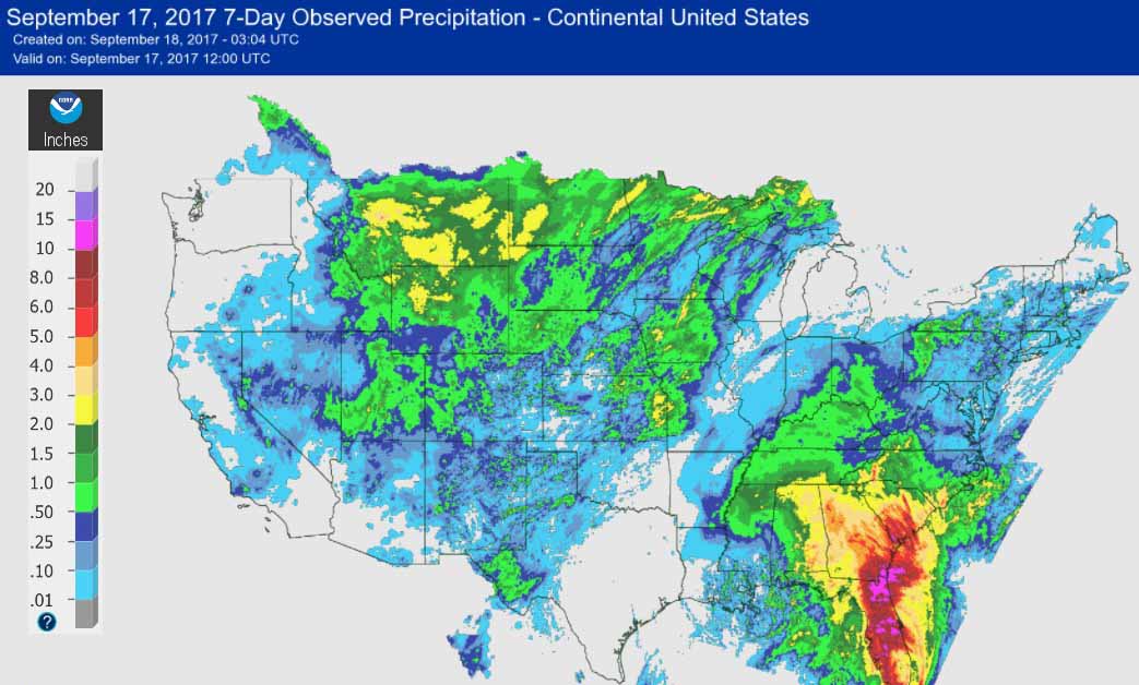
Most of Montana and eastern Idaho had over half an inch of precipitation, but extreme northwest Montana, northwest California, northern Idaho, and most of Oregon and Washington received very little.

Estimated precipitation received for the 7-day period ending Sunday Evening, September 17, 2017.

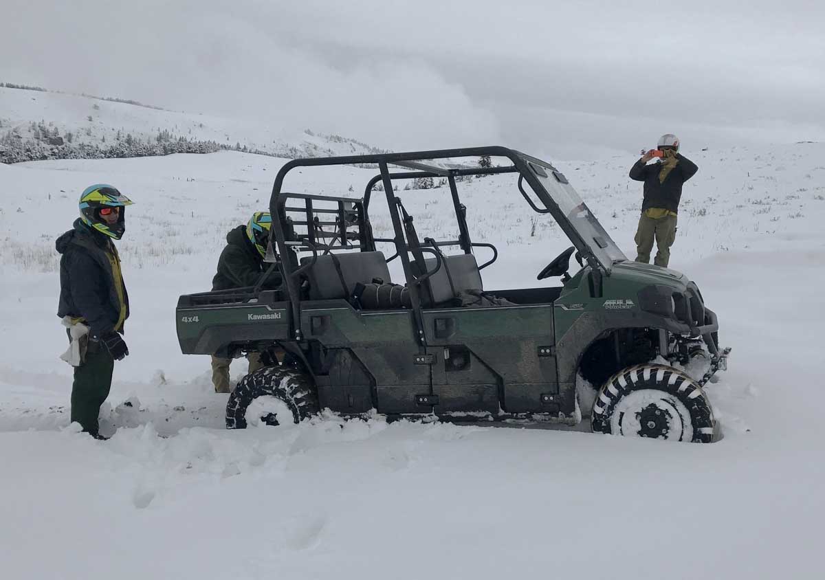
For example, some evacuations are still in effect for the West Fork Fire in northwest Montana north of Libby. But in the photo below firefighters on the Blacktail Fire northeast of Bozeman look like they are on a winter snow adventure.

Blacktail fire snow Montana
Firefighters on the Blacktail Fire, 48 miles northeast of Bozeman. Photo by Jade Martin.

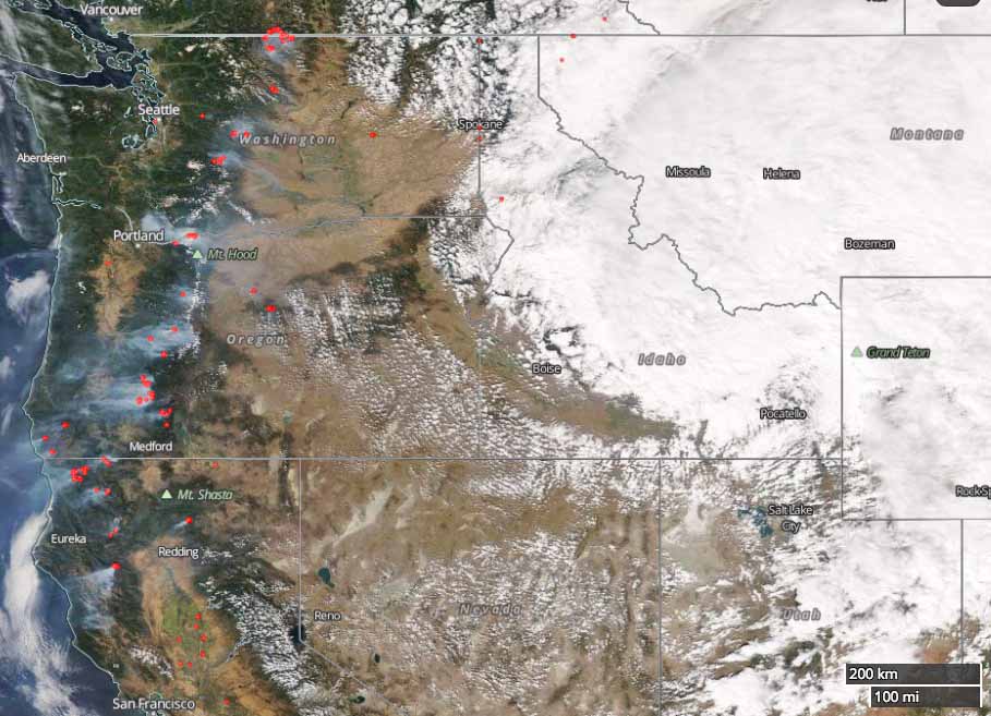
Many of the wildfires in extreme northwest California and the Cascades of Oregon and Washington are still active. The satellite photo of that area is the most recent we could find that was at least partially free of clouds. On Friday smoke plumes were still very visible from hundreds of miles overhead.

satellite photo fires northwest united states
Satellite photo of the northwest United States, September 15, 2017. The red dots represent heat that the satellite was able to detect where the clouds were not too thick. NASA.

Continue reading “Rain and snow affect some fires in the Northwest — but not all”