Pending federal appropriations bill includes increase for suppression, decrease for volunteer assistance

Opinion: How SHOULD the federal fire agencies be funded?

Above: The Washington, DC headquarters of the U.S. Forest Service. Photo by Bill Gabbert.

(Originally published at 9:53 a.m. MDT September 8, 2017)

The wildland fire appropriations bill that is being considered in the House of Representatives does not have any earth-shaking changes but it includes slight increases for fire suppression and fuels management, while State and Volunteer Fire Assistance would be cut.

H.R. 3354 would determine the amount of funding for about a dozen agencies, most of them within the Department of the Interior — including the Bureau of Land Management, Bureau of Indian Affairs, Fish and Wildlife Service,  National Park Service, and Forest Service.
Andy's Hump Fire, Idaho
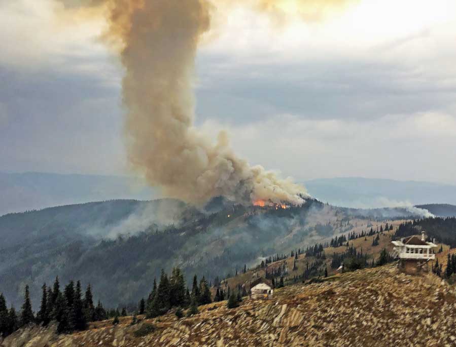
Andy’s Hump Fire, Idaho. Inciweb.

It is being debated in committees and will undoubtedly change before it is approved in the House and Senate and signed by the President, but here are a few of the highlights related to wildland fire. The numbers are the appropriations for the Forest Service only.

  • The bill will again use the rolling 10-year average of fire suppression expenses as part of the computation for the new budget. Since the average went up, the bill includes a $15 million increase in suppression.
  • Hazardous fuel management increases by $3 million (less than 1 percent) to $393 million.
  • Within the Forest Service, hazardous fuel management funds will be moved from the Suppression account to the National Forest System Appropriation, as requested by the agency.
  • State Fire Assistance went down by $2 million to $76 million.
  • Volunteer Fire Assistance decreased by $1 million to $14 million.

The legislation will get rid of the Federal Land Assistance, Management, and Enhancement Act (FLAME). It was created in 2008 intended to provide dedicated funding for suppressing fires and hazardous fuel reduction treatments. The way it was managed by Congress over the years made it irrelevant and will now be collapsed into the Suppression account.

dollar signThere is still no fix for the “fire borrowing” issue that results in funds being taken from non-fire accounts when suppression expenses are exhausted. These accounts are usually reimbursed by Congress, but it can happen months later, which can cause chaos in programs unrelated to fire.

Our Opinion

Obviously the fire borrowing train wreck has to be fixed. This ridiculous situation should be a no-brainer.

Fires are getting larger, causing major disruptions in the lives of many taxpayers. Basing the funds for suppression on the 10-year average cost too often does not work.

The 10-year average of the acres burned in the U.S. to this date (September 8) is 5,515,998, while 8,036,858 acres have burned to date this year (National Interagency Fire Center, September 8, 2017). That is a 48 percent increase over the average.
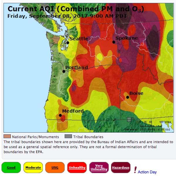
Air Quality Index fire smoke
Air Quality Index at 9 a.m. PDT September 8, 2017 for areas in Washington, Oregon, Idaho, and Montana. Smoke in this case is the main culprit.

Smoke from wildfires is affecting the health of millions. Often this summer the air quality in large areas of the Northwest has been classified according to air quality monitoring stations as Unsafe for Sensitive Groups, Unhealthy, Very Unhealthy, or Hazardous. A friend who has respiratory issues in South Dakota, hundreds of miles from any large fires, has been seriously affected by wildfire smoke this summer. Some families are having to take their children with asthma to hospitals when the smoke invades their community.

meeting Eagle Creek Fire
Community meeting at Hood River, Oregon for residents affected by the Eagle Creek Fire in the Columbia Gorge, September 7, 2017. Inciweb.

More successful fire suppression would reduce the smoke impacts on millions of people.

General Norman Schwarzkopf Jr.
General Norman Schwarzkopf Jr. November 1988. Wikipedia.

Not all fires are aggressively fought by the federal agencies. We can debate whether that is the best way to manage forests, but even if there is no change in that policy, more can be done to keep new fires from becoming large — and we can more aggressively suppress all unwanted fires. Successful battlefield Generals, including Norman Schwarzkopf, understand the concept.

A Wikipedia article about the General describes planning in 1991 for Desert Storm in Kuwait and Iraq:

U.S. commanders from the beginning wanted a quick conflict characterized by decisive, overwhelming force, as opposed to the gradual escalation of U.S. involvement as had been seen in Vietnam. Schwarzkopf in particular was very adamant that many of the policies governing military operations in Vietnam, especially slow escalation of air power and troop force, not recur. His plan for direct and overwhelming force was initially criticized in Washington as uncreative.

The fighting was basically over in less than 100 hours.

The same concepts relating to air power and troop force can be applied to fighting another enemy — unwanted wildfires. A timid initial attack on a new fire can allow it to spread to the point where no suppression attempts will be successful until there are major changes in the weather, fuels, or topography.

Dr. Gabbert prescription new fires magafires prevent

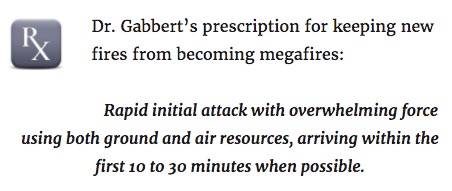
Some of us remember when aggressive initial attack was the norm in the federal agencies rather than the exception. In the short run it costs more to dispatch an overwhelming force to a new fire than using a timid approach with few resources arriving in the first 10 to 30 minutes, but it can prevent later expenses of tens of millions of dollars — and also prevent hundreds of firefighters from being tied up on one fire for weeks or months, as well as the loss of private property, evacuations, smoke, and timber being destroyed.

The cost and disruption caused by evacuations from fires is rarely openly discussed, but the act of packing belongings and transporting a family to another location for multiple days can be an extreme hardship, not only because of the inconvenience, but also the cost for the evacuees, and the businesses whose customers temporarily live somewhere else or avoid the area. It would not surprise me if an aggressive attorney recruited evacuees who want to sue to recover their costs, claiming the fire could have or should have been suppressed before it grew large.

Funding the federal fire agencies and managing them so that they CAN and WILL as a matter of policy attack new fires aggressively, becomes increasingly important as firefighters are battling multiple megafires each year.

They need to have the technology that will enable them to fight their enemy more efficiently and safely. Drones can provide real time information about the behavior and location of fires. The small aircraft can also serve as radio repeaters for voice communication and location trackers for firefighting resources. These safety-related concepts can help to provide the Holy Grail of Wildland Firefighter Safety — knowing the real time location of the fire and firefighters.

Aerial firefighting resources, including helicopters and air tankers, are most effective when used during the first hour of a new fire. In order to have them reliably available for initial attack the U.S. Forest Service should contract for or operate 40 large or very large air tankers on exclusive use (EU) contracts. And instead of reducing the number of Type 1 helicopters on EU contracts from 34 to 28 as was done this year, there should be at least 45.

(Update at 10:22 p.m MDT September 8, 2017:  The USA Today has an article about the USFS budget, including quotes from the Secretary of Agriculture and … the article above.)

Satellite detects heat from wildfires, September 7

(Originally published at 6:36 p.m. MDT September 7, 2017.)

Large wildfires Washington Oregon northern California
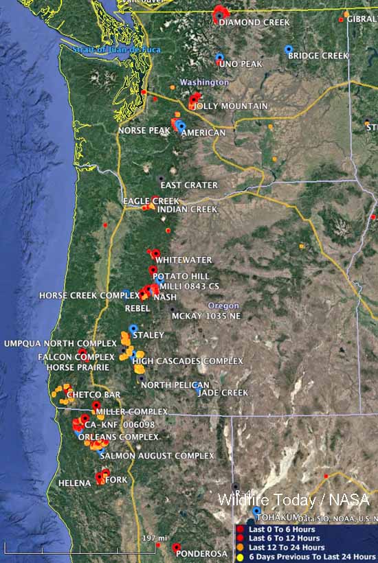
Large wildfires currently active in Washington, Oregon, and northern California. The red, yellow, and orange dots represent heat detected by a satellite in the 24 hour period ending at 10 a.m. MDT September 6.

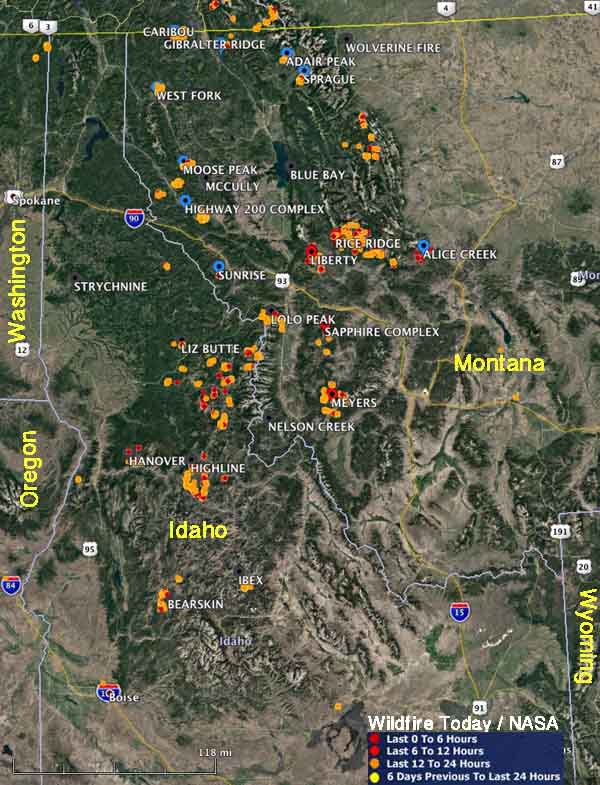
These maps show heat that was detected by a satellite on wildfires in the northwestern United States during the 24-hour period ending at 6 p.m. Thursday September 7, 2017. We did not include heat from the 6 days previous to the last 24 hours.

If there was heat found, it means the fires are still active, however some of it could be from proactive burning by firefighters to secure the area between firelines and the edge of the fires.

map wildfires idaho montana
Large wildfires currently active in Montana and Idaho. The red, yellow, and orange dots represent heat detected by a satellite in the 24 hour period ending at 6 p.m. MDT September 7.

Wildfire smoke maps, September 7, 2017

Above: The map shows the distribution of wildfire smoke during the afternoon of September 7, 2017.

(Originally published at 6:04 p.m. MDT September 7, 2017.)

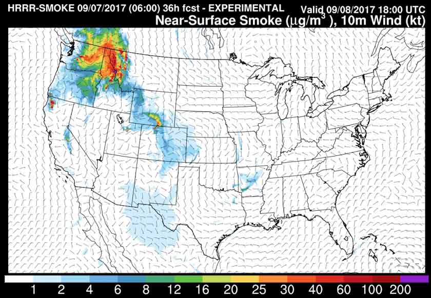
The map below is the experimental forecast for noon MDT on Friday September 8, 2017. Both products are from NOAA.

smoke map wildfire
The map is an experimental product — a forecast for smoke at noon MDT on Friday September 8, 2017.

Eagle Creek Fire in Columbia River Gorge slows, but still adds over 2,000 acres

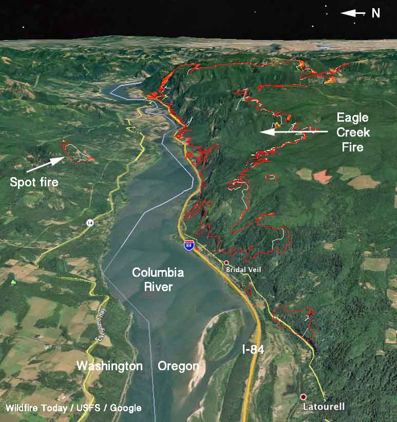
The fire has burned 33,382 acres, which includes a 209-acre spot fire across the Columbia River in Washington.

On the map above, the red line was the perimeter of the Eagle Creek Fire at 2:15 a.m. PDT September 7, 2017. The white line was the perimeter about 24 hours before.

(Originally published at 9:06 am PDT September 7, 2017)

The Eagle Creek Fire that is believed to have been started by a teenager playing with fireworks, continued to spread Wednesday but more slowly than in previous days, adding another 2,453 acres mostly on the south and northeast sides. The spot fire across the Columbia River in Washington has expanded to 209 acres.

The main fire is 11 miles east of Gresham.

Interstate 84 is still closed. The Oregon Department of Transportation said Wednesday that there are nearly 2,000 trees that are in danger of falling into the highway.

Snow plows are being used to push fallen trees off the Historic Columbia River Highway, which is also closed “for an undetermined amount of time”, the DOT said.

The weather forecast indicates that the air quality should improve in the Portland area over the next few days. The prediction is for a “moderate” Air Quality Index for Thursday and Friday of this week. The forecast also calls for a chance of rain off and on over the next couple of days.

Air Quality Index Oregon Washington
Air Quality Index for Oregon and Washington 7 a.m. PDT, September 7, 2017.
map Eagle Creek fire
3-D map of the Eagle Creek Fire. The red line was the perimeter at 2:15 a.m. PDT September 7, 2017. The white line was the perimeter about 24 hours before.

Military mobilized to help fight wildfires

Above: Personal Protective Equipment is distributed to soldiers at Joint Base Lewis-McChord in preparation for deployment to the Umpqua North Fire in Oregon.

(Originally published at 7:53 a.m. MDT September 7r, 2017)

With the National Preparedness Level at 5, the highest level, the National Interagency Fire Center (NIFC) in Boise, Idaho has mobilized active duty military personnel to serve as firefighters to assist with wildfire suppression efforts.

The National Multi-Agency Coordinating Group (NMAC) at NIFC requested the Department of Defense to provide 200 active duty military personnel to assist with firefighting efforts. The DoD has approved the request and identified the 1-2 Stryker Brigade Combat Team (23rd Brigade Engineer Battalion and 1st Battalion 23rd Infantry Regiment), 7th Infantry Division at Joint Base Lewis-McChord (JBLM) in Washington to provide the active duty military personnel. The Soldiers will be organized into ten crews of 20 persons each, all of which will be sent to the Umpqua North Complex which is burning on approximately 30,000 acres on the Umpqua National Forest, approximately 50 miles east of Roseburg, Oregon.

“We are committed to continuing to do everything we can to provide the firefighters, aircraft, engines, and other wildfire suppression assets that Incident Commanders need to protect lives, property, and valuable natural and cultural resources,” said Dan Buckley, Chair of NMAC. “The U.S. military is a key partner in wildland firefighting and we greatly appreciate their willingness to provide us with Soldiers to serve as firefighters as well as aircraft to help with wildfire suppression efforts.”

Their training, which began September 6, is expected to conclude by September 9th, and the Soldiers are expected to begin working on a wildfire on September 10th. While on a wildfire, the Soldiers will be accompanied by experienced wildland fire strike team leaders and crew bosses from wildland fire management agencies.

The training will consist of one day of classroom training at JBLM and two days of field training when the Soldiers reach the wildfire that they will be assigned to.

The last time that active duty military personnel were mobilized to serve as wildland firefighters was in August, 2015 when 200 soldiers from the 17th Field Artillery Brigade based out of JBLM were mobilized to work on wildfires in Washington for 30 days. The last time before that was in 2006. Currently, several states – including Oregon, Montana, and Washington – have mobilized National Guard helicopters and personnel to serve as wildland firefighters to assist with wildfire suppression efforts.

army soldiers Onata Fire
File photo. Part of the Army’s assignment on the Onata Fire in 2015 was to assist putting in a hose lay as part of preparation for a planned burnout. Robert “Hippie” Horn (left) of North Dakota Forest Service hands rolls of hose to soldiers to distribute along a road. Photo by Tom Story,  August, 2015.

Eagle Creek fire burns structures and forces evacuations along the Columbia River Gorge

Above: 3-D map of the Eagle Creek Fire looking southeast, showing the perimeter at 7:30 p.m. PDT September 5, 2017.

(Originally published at 12:22 p.m. PDT, September 6, 2017)

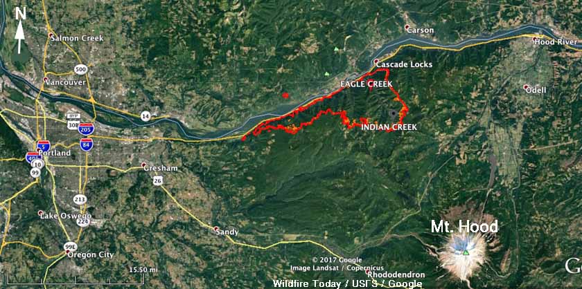
The Eagle Creek Fire that has been burning since September 2 along the Columbia River Gorge just west of Cascade Locks on the Washington/Oregon border has merged with the nearby Indian Creek Fire, which together have blackened 30,929 acres. The blaze is about 10 miles east of the Portland suburbs.

Most of the fire is on the south side of the river in Oregon, but it has jumped across the river into Washington near Archer Mountain.

Six structures have burned and there is a report that at least one of them is a residence, with the others being outbuildings.

Eagle Creek Fire
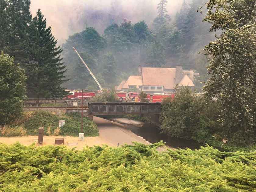
Firefighters protect the Multnomah Lodge at the Eagle Creek Fire, September 5, 2017. Inciweb.

Several communities are under evacuation orders and a shelter has been established at Mt. Hood Community College, at 3691 NE 17th Drive, Gresham, OR. For information regarding evacuations in Skamania County, contact the Skamania County Emergency Operations Center at 509-427-8076.

Firefighters will be conducting burnout operations on September 6th from Bridge of the Gods to Bonneville Dam. There will be large plumes of smoke visible during the day.

 map Eagle Creek Fire
Map of the Eagle Creek Fire showing the perimeter at 7:30 p.m. PDT September 5, 2017.

Willamette Week reported that a Portland resident saw a teenage boy using fireworks that may have started the fire. On September 5 the Oregon State Police announced that a 15-year old boy from Vancouver, Washington is a suspect.

Continue reading “Eagle Creek fire burns structures and forces evacuations along the Columbia River Gorge”